Satellite Imagery
Satellite Imagery
HER: Angus SMR per Aberdeenshire Council NO64NE0007 (None)
NMR: NO 64 NE 7 (35438)
SM: 5587
NGR: NO 6972 4643
X: 369720 Y: 746430 (OSGB36)
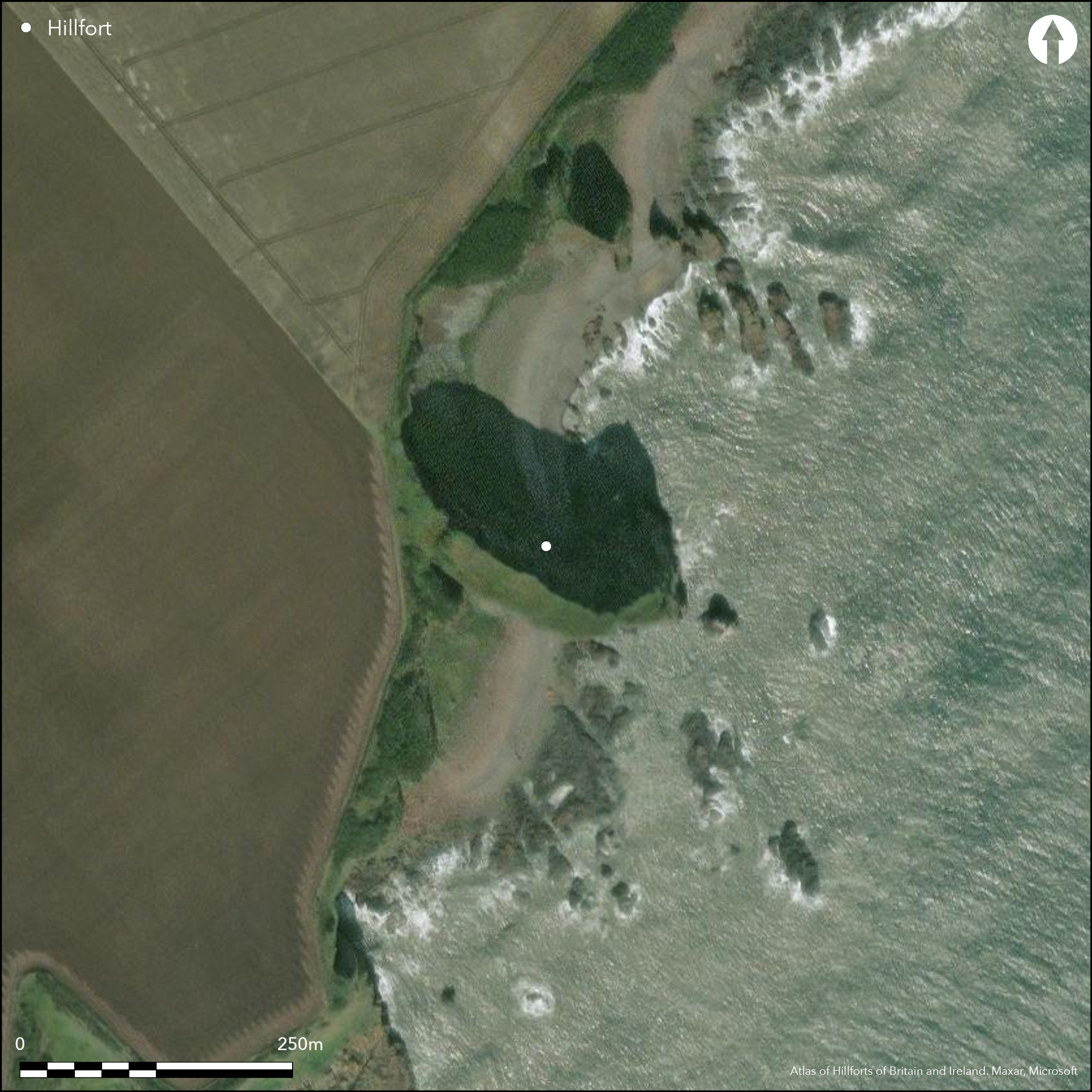
This promontory fort is situated on the cliffs NE of West Mains. A narrow finger of land girt with precipices along its flanks, the seaward end evidently spans a natural arch, while continuing erosion in a narrow crevice on the S side has constricted the neck still further. At the top of this crevice a rocky scarp cuts across the neck of the promontory and is crowned by the remains of the inner rampart, which varies between 0.3m in height at the cliff edge on the N to 1m on the S. The outer defences are disposed to either side of a central entrance causeway approaching from the W, two ditches with a medial rampart lying to the N and three ditches with intermediate ramparts on the S. The ditches are probably adapted from natural gullies, the broadest measuring some 6m across, while the ramparts are from 3m to 6m in thickness and stand between 1m and 3m high above the bottoms of the ditches. The interior measures a maximum of 110m in length from ESE to WNW by a maximum of 21m transversely, and though traces of buildings were reported here in 1843 (Cummings 1843), possibly on the assumption that this is the site of a medieval castle, they are not in evidence today, and the only features that are visible are the remains of a Home Guard lookout post at the extreme E tip of the promontory; this has been reduced to two rectangular hollows, each measuring about 8m in length by 5m in breadth.
Citizen Science: ✗
Reliability of Data: Confirmed
Reliability of Interpretation: Confirmed
X: -277729 Y: 7680582 (EPSG: 3857)
Longitude: -2.4948809693691145 Latitude: 56.60882275414828 (EPSG:4326)
Country: Scotland
Current County or Unitary Authority: Angus
Historic County: Angus
Current Parish/Community/Council/Townland: Inverkeilor
None
| Extant | ✓ |
| Cropmark | ✗ |
| Likely Destroyed | ✗ |
None
| Woodland | ✗ |
| Commercial Forestry Plantation | ✗ |
| Parkland | ✗ |
| Pasture (Grazing) | ✗ |
| Arable | ✗ |
| Scrub/Bracken | ✗ |
| Bare Outcrop | ✗ |
| Heather/Moorland | ✗ |
| Heath | ✗ |
| Built-up | ✗ |
| Coastal Grassland | ✓ |
| Other | ✗ |
None
| Contour Fort | ✗ |
| Partial Contour Fort | ✗ |
| Promontory Fort | ✓ |
| Hillslope Fort | ✗ |
| Level Terrain Fort | ✗ |
| Marsh Fort | ✗ |
| Multiple Enclosure Fort | ✗ |
| Hilltop | ✗ |
| Coastal Promontory | ✓ |
| Inland Promontory | ✗ |
| Valley Bottom | ✗ |
| Knoll/Hillock/Outcrop | ✗ |
| Ridge | ✗ |
| Cliff/Plateau-edge/Scarp | ✗ |
| Hillslope | ✗ |
| Lowland | ✗ |
| Spur | ✗ |
Dominant Topographic Feature: None
| North | ✗ |
| Northeast | ✗ |
| East | ✗ |
| Southeast | ✗ |
| South | ✗ |
| Southwest | ✗ |
| West | ✗ |
| Northwest | ✗ |
| Level | ✓ |
Altitude: 50.0m
N/A
In the absence of excavation, there are neither stratified artefacts nor radiocarbon dates to provide a chronology for the defences.
Reliability: D - None
| Pre 1200BC | ✗ |
| 1200BC - 800BC | ✗ |
| 800BC - 400BC | ✗ |
| 400BC - AD50 | ✗ |
| AD50 - AD400 | ✗ |
| AD400 - AD 800 | ✗ |
| Post AD800 | ✗ |
| Unknown | ✓ |
| Pre Hillfort: | None |
| Post Hillfort: | None |
Named on the 1st and 2nd editions of the OS 6-inch map, but not as an antiquity.
| 1st Identified Map Depiction (1794): | Annotated Ruins of Prail Castle on John Ainslie's Map of Forfar or shire of Angus (1794) |
| 1st Identified Written Reference (1843): | Noted (Cumming 1843) |
| Other (1958): | Surveyed at 1:2500 by the OS |
| Other (1965): | Visited by the OS |
| Other (1978): | Visited by RCAHMS |
| Other (1993): | Scheduled |
There is an area of disturbance to the rear of the inner rampart and the remains of a Home Guard lookout post at the extreme E tip of the promontory
None
| None | ✓ |
| Spring | ✗ |
| Stream | ✗ |
| Pool | ✗ |
| Flush | ✗ |
| Well | ✗ |
| Other | ✗ |
Area of disturbance and two rectangular hollows that are the remains of the Home Guard post at the E end of the promontory
| No Known Features | ✗ |
| Round Stone Structures | ✗ |
| Rectangular Stone Structures | ✗ |
| Curvilinear Platforms | ✗ |
| Other Roundhouse Evidence | ✗ |
| Pits | ✗ |
| Quarry Hollows | ✗ |
| Other | ✓ |
None
| No Known Excavation | ✓ |
| Pits | ✗ |
| Postholes | ✗ |
| Roundhouses | ✗ |
| Rectangular Structures | ✗ |
| Roads/Tracks | ✗ |
| Quarry Hollows | ✗ |
| Other | ✗ |
| Nothing Found | ✗ |
None
| No Known Geophysics | ✓ |
| Pits | ✗ |
| Roundhouses | ✗ |
| Rectangular Structures | ✗ |
| Roads/Tracks | ✗ |
| Quarry Hollows | ✗ |
| Other | ✗ |
| Nothing Found | ✗ |
None
| No Known Finds | ✓ |
| Pottery | ✗ |
| Metal | ✗ |
| Metalworking | ✗ |
| Human Bones | ✗ |
| Animal Bones | ✗ |
| Lithics | ✗ |
| Environmental | ✗ |
| Other | ✗ |
NO APPARENT FEATURES
| APs Not Checked | ✗ |
| None | ✓ |
| Roundhouses | ✗ |
| Rectangular Structures | ✗ |
| Pits | ✗ |
| Postholes | ✗ |
| Roads/Tracks | ✗ |
| Other | ✗ |
See main summary
| 1: | None |
| 2: | None |
Guard Chambers: ✗
Chevaux de Frise: ✗
| 1. Simple Gap (West): | Central causeway through the defences |
Up to three ramparts and ditches barring access to a promontory
| Area 1: | 0.19ha. |
| Total: | 0.19ha. |
Total Footprint Area: Noneha.
None
| ✗ | None |
| ✗ | None |
| NE Quadrant: | 0 |
| SE Quadrant: | 0 |
| SW Quadrant: | 0 |
| NW Quadrant: | 3 |
| Total: | 3 |
| Partial Univallate | ✗ |
| Univallate | ✗ |
| Partial Bivallate | ✗ |
| Bivallate | ✗ |
| Partial Multivallate | ✓ |
| Multivallate | ✗ |
| Unknown | ✗ |
| Partial Univallate | ✗ |
| Univallate | ✗ |
| Partial Bivallate | ✗ |
| Bivallate | ✗ |
| Partial Multivallate | ✗ |
| Multivallate | ✗ |
None
| None | ✗ |
| Earthen Bank | ✓ |
| Stone Wall | ✗ |
| Rubble | ✗ |
| Wall-walk | ✗ |
| Evidence of Timber | ✗ |
| Vitrification | ✗ |
| Other Burning | ✗ |
| Palisade | ✗ |
| Counter Scarp Bank | ✗ |
| Berm | ✗ |
| Unfinished | ✗ |
| Other | ✗ |
None
| None | ✗ |
| Earthen Bank | ✗ |
| Stone Wall | ✗ |
| Murus Duplex | ✗ |
| Timber-framed | ✗ |
| Timber-laced | ✗ |
| Vitrification | ✗ |
| Other Burning | ✗ |
| Palisade | ✗ |
| Counter Scarp Bank | ✗ |
| Berm | ✗ |
| Unfinished | ✗ |
| No Known Excavation | ✓ |
| Other | ✗ |
| ✗ | None |
| ✓ | None |
Number of Ditches: 3
| ✗ | None |
Carrie, J (1881) Ancient Things in Angus: A Series of Articles on Ancient Things, Manners and Customs, in Forfarshire. Arbroath
Cumming, G (Publisher) (1848) Forfarshire Illustrated. Dundee
Atlas of Hillforts:
Wikidata:
This work is licensed under CC BY-SA 4.0![]()
![]()
![]() and should be cited as:
and should be cited as:
Lock, Gary and Ralston, Ian. 2024. Atlas of Hillforts of Britain and Ireland. Available at: https://hillforts.arch.ox.ac.uk
Document Version 1.1