Satellite Imagery
Satellite Imagery
HER: Angus SMR per Aberdeenshire Council NO64SE0004 (None)
NMR: NO 64 SE 4 (35531)
SM: 2875
NGR: NO 6819 4416
X: 368190 Y: 744160 (OSGB36)
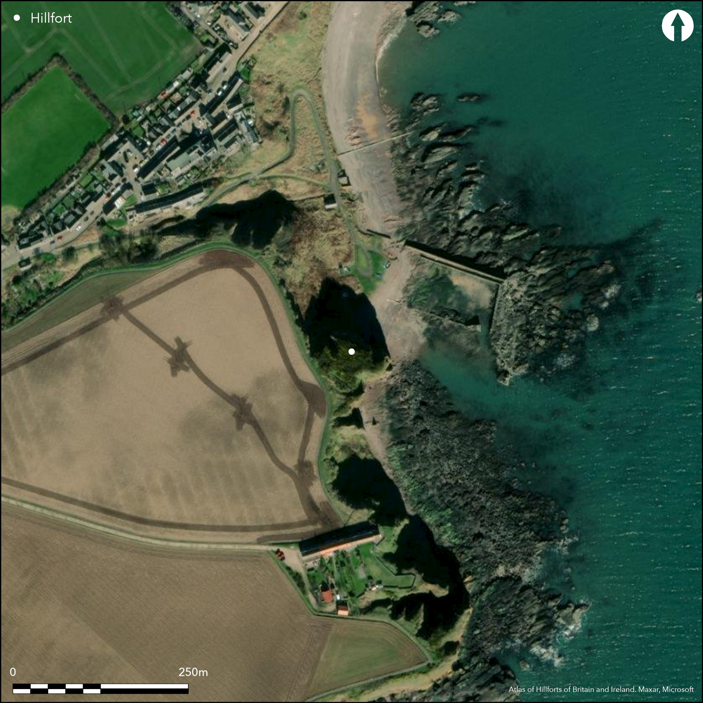
This small fortification occupies a precipitous promontory overlooking the harbour at Auchmithie. The only possible line of approach is from the SW, and here access is barred by at least two ramparts with external ditches, pierced by a central entrance causeway. The roughly triangular interior measures a maximum of 33m from N to S by 30m transversely (0.05ha). The ditches are up to 5m broad and the best preserved of the ramparts, the middle rampart, forms a bank up to 1.7m high. Excavations carried out between 1969 and 1974 examined the greater part of the interior, revealing a metalled pathway, patches of paving and cobbling, several hearths and a scatter of post-holes, but no coherent pattern can be discerned (Ralston 1986). Likewise the character of the inner rampart and possible evidence of timberwork noted on the N side of the entrance.
Citizen Science: ✗
Reliability of Data: Confirmed
Reliability of Interpretation: Confirmed
X: -280472 Y: 7676438 (EPSG: 3857)
Longitude: -2.5195249439368514 Latitude: 56.588328315194936 (EPSG:4326)
Country: Scotland
Current County or Unitary Authority: Angus
Historic County: Angus
Current Parish/Community/Council/Townland: Arbroath And St Vigeans
None
| Extant | ✓ |
| Cropmark | ✗ |
| Likely Destroyed | ✗ |
Currently blanketed in gorse
| Woodland | ✗ |
| Commercial Forestry Plantation | ✗ |
| Parkland | ✗ |
| Pasture (Grazing) | ✗ |
| Arable | ✗ |
| Scrub/Bracken | ✓ |
| Bare Outcrop | ✗ |
| Heather/Moorland | ✗ |
| Heath | ✗ |
| Built-up | ✗ |
| Coastal Grassland | ✓ |
| Other | ✗ |
None
| Contour Fort | ✗ |
| Partial Contour Fort | ✗ |
| Promontory Fort | ✓ |
| Hillslope Fort | ✗ |
| Level Terrain Fort | ✗ |
| Marsh Fort | ✗ |
| Multiple Enclosure Fort | ✗ |
| Hilltop | ✗ |
| Coastal Promontory | ✓ |
| Inland Promontory | ✗ |
| Valley Bottom | ✗ |
| Knoll/Hillock/Outcrop | ✗ |
| Ridge | ✗ |
| Cliff/Plateau-edge/Scarp | ✗ |
| Hillslope | ✗ |
| Lowland | ✗ |
| Spur | ✗ |
Dominant Topographic Feature: None
| North | ✗ |
| Northeast | ✗ |
| East | ✗ |
| Southeast | ✗ |
| South | ✗ |
| Southwest | ✗ |
| West | ✗ |
| Northwest | ✗ |
| Level | ✓ |
Altitude: 30.0m
N/A
While the presence of a rotary quern may indicate a late-Iron age occupation, the rubbers from saddle querns may be rather earlier. There are no diagnostic finds and while Joanna Close-Brookes (1986) argued the case for the similarity of the coarse stone tool assemblage to that from West Mains of Ethie (Atlas No. 3093), which was associated with 1st and 2nd century artefacts, this is hardly conclusive.
Reliability: D - None
| Pre 1200BC | ✗ |
| 1200BC - 800BC | ✗ |
| 800BC - 400BC | ✗ |
| 400BC - AD50 | ✗ |
| AD50 - AD400 | ✗ |
| AD400 - AD 800 | ✗ |
| Post AD800 | ✗ |
| Unknown | ✓ |
| Pre Hillfort: | Cupmarked stone |
| Post Hillfort: | None |
The excavation archive is held by RCAHMS.
| 1st Identified Map Depiction (1859): | Annotated Fort on the 1st edition OS 25-inch map (Forfar 1865, sheet 47.5) |
| Other (1899): | Description by David Christison (1900, 60) |
| Other (1956): | Description for RCAHMS Survey of Marginal Lands |
| Other (1958): | Visited by the OS |
| Other (1965): | Resurveyed at 1:2500 by the OS |
| Excavation (1967): | By Mr D A Gardner and the Arbroath Antiquary Club (Ralston 1986) |
| Excavation (1968): | By Mr D A Gardner and the Arbroath Antiquary Club (Ralston 1986) |
| Excavation (1969): | By Mr D A Gardner and the Arbroath Antiquary Club (Ralston 1986) |
| Other (1969): | Scheduled |
| Excavation (1970): | By Mr D A Gardner and the Arbroath Antiquary Club (Gardner 1970; Ralston 1986) |
| Excavation (1971): | By Mr D A Gardner and the Arbroath Antiquary Club (Ralston 1986) |
| Excavation (1972): | By Mr D A Gardner and the Arbroath Antiquary Club (Ralston 1986) |
| Excavation (1973): | By Mr D A Gardner and the Arbroath Antiquary Club (Ralston 1986) |
| Excavation (1974): | By Mr D A Gardner and the Arbroath Antiquary Club (Ralston 1986) |
| Earthwork Survey (1986): | By Ian Ralston and Kirsty Sabine (Ralston 1986, 103, fig 2) |
Excavations within the interior revealed a metalled pathway, patches of paving and cobbling, several hearths and a scatter of post-holes.
None
| None | ✓ |
| Spring | ✗ |
| Stream | ✗ |
| Pool | ✗ |
| Flush | ✗ |
| Well | ✗ |
| Other | ✗ |
None
| No Known Features | ✓ |
| Round Stone Structures | ✗ |
| Rectangular Stone Structures | ✗ |
| Curvilinear Platforms | ✗ |
| Other Roundhouse Evidence | ✗ |
| Pits | ✗ |
| Quarry Hollows | ✗ |
| Other | ✗ |
hearths
| No Known Excavation | ✗ |
| Pits | ✗ |
| Postholes | ✓ |
| Roundhouses | ✗ |
| Rectangular Structures | ✗ |
| Roads/Tracks | ✗ |
| Quarry Hollows | ✗ |
| Other | ✓ |
| Nothing Found | ✗ |
None
| No Known Geophysics | ✓ |
| Pits | ✗ |
| Roundhouses | ✗ |
| Rectangular Structures | ✗ |
| Roads/Tracks | ✗ |
| Quarry Hollows | ✗ |
| Other | ✗ |
| Nothing Found | ✗ |
The finds were mainly coarse stone tools but include two rubbing stones from saddle querns, a rotary quern and seven stone discs; there was also a perforated shale disc. Later material included a scatter of medieval sherds, a piece of lead shot and a small piece of lead slag.
| No Known Finds | ✗ |
| Pottery | ✗ |
| Metal | ✓ |
| Metalworking | ✗ |
| Human Bones | ✗ |
| Animal Bones | ✗ |
| Lithics | ✓ |
| Environmental | ✗ |
| Other | ✓ |
NO APPARENT FEATURES
| APs Not Checked | ✗ |
| None | ✓ |
| Roundhouses | ✗ |
| Rectangular Structures | ✗ |
| Pits | ✗ |
| Postholes | ✗ |
| Roads/Tracks | ✗ |
| Other | ✗ |
See main summary
| 1: | None |
| 2: | None |
Guard Chambers: ✗
Chevaux de Frise: ✗
| 1. Simple Gap (South west): | None |
At least two ramparts with external ditches cutting off a precipitous promontory
| Area 1: | 0.05ha. |
| Total: | 0.05ha. |
Total Footprint Area: 0.15ha.
None
| ✗ | None |
| ✗ | None |
| NE Quadrant: | 0 |
| SE Quadrant: | 0 |
| SW Quadrant: | 2 |
| NW Quadrant: | 0 |
| Total: | 2 |
| Partial Univallate | ✗ |
| Univallate | ✗ |
| Partial Bivallate | ✓ |
| Bivallate | ✗ |
| Partial Multivallate | ✗ |
| Multivallate | ✗ |
| Unknown | ✗ |
| Partial Univallate | ✗ |
| Univallate | ✗ |
| Partial Bivallate | ✗ |
| Bivallate | ✗ |
| Partial Multivallate | ✗ |
| Multivallate | ✗ |
None
| None | ✗ |
| Earthen Bank | ✓ |
| Stone Wall | ✗ |
| Rubble | ✗ |
| Wall-walk | ✗ |
| Evidence of Timber | ✗ |
| Vitrification | ✗ |
| Other Burning | ✗ |
| Palisade | ✗ |
| Counter Scarp Bank | ✗ |
| Berm | ✗ |
| Unfinished | ✗ |
| Other | ✗ |
Few post-holes and a row of stones in shallow sockets that may 'have served as chocking for timber uprights' (Ralston 1986, 110)
| None | ✗ |
| Earthen Bank | ✓ |
| Stone Wall | ✗ |
| Murus Duplex | ✗ |
| Timber-framed | ✗ |
| Timber-laced | ✗ |
| Vitrification | ✗ |
| Other Burning | ✗ |
| Palisade | ✗ |
| Counter Scarp Bank | ✗ |
| Berm | ✗ |
| Unfinished | ✗ |
| No Known Excavation | ✗ |
| Other | ✓ |
| ✗ | None |
| ✓ | None |
Number of Ditches: 2
| ✗ | None |
Christison, D (1900) 'The forts, "camps", and other field-works of Perth, Forfar and Kincardine'. Proc Soc Antiq Scot 34 (1899-1900), 43-120
Gardner, D A (1970) 'Auchmithie: promontory fort'. Disc Exc Scot (1970), 2
Ralston, I (1987) 'The Arbroath Antiquary Club's excavations at Castle Rock promontory fort, Auchmithie, Arbroath and St Vigeans, Angus District'. Proc Soc Antiq Scot 116 (1986), 101-15
Atlas of Hillforts:
Wikidata:
This work is licensed under CC BY-SA 4.0![]()
![]()
![]() and should be cited as:
and should be cited as:
Lock, Gary and Ralston, Ian. 2024. Atlas of Hillforts of Britain and Ireland. Available at: https://hillforts.arch.ox.ac.uk
Document Version 1.1