Satellite Imagery
Satellite Imagery
HER: Angus SMR per Aberdeenshire Council NO64SE0005 (None)
NMR: NO 64 SE 5 (35532)
SM: 2876
NGR: NO 6805 4342
X: 368050 Y: 743420 (OSGB36)
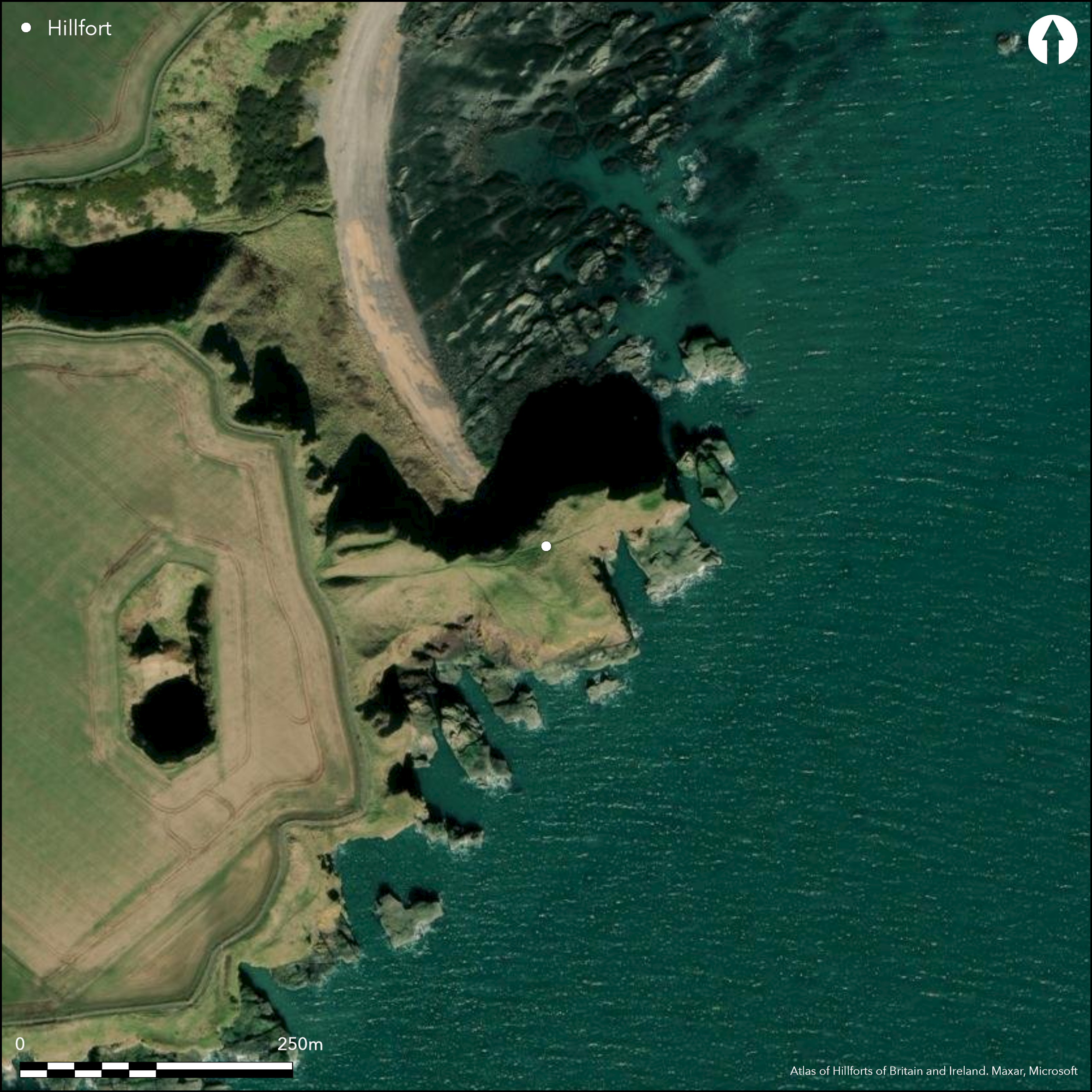
This small fortification is situated on the raised tip of a heavily eroded promontory girt with high cliffs and approachable only from the W across a narrow neck. The defences comprise a single earthen rampart from 4m to 6m in thickness and up to 1.2m in height, which stands where the tip of the promontory broadens out above the neck. The top of the promontory, however, measures no more than 40m in breadth at this point and while its N margin extends in a narrow finger about 55m out into the sea beyond the rampart, a substantial part of the interior must have collapsed into the sea cave eroded into its S flank. On the S flank below the top of the promontory a small area of eroding midden was found in 1998 and a perforated sandstone disc and animal bones were recovered; a spindle whorl had previously been found at the fort (Dundee Museum). In addition to the rampart defending the tip of the promontory, there is also a curious arrangement of banks on the landward side, described in the Scheduling document (1998) as 'an enclosure measuring about 15m by 8m...[possibly] positioned to control access to the main part of the fort'; aerial photographs show what may be a trackway hollow leading down to the narrow neck, with two banks some 30m in length set parallel to each other along the irregular cliff edge on the N. The date and purpose of these remains is unknown. Equally uncertain is the character of some cropmarks photographed in 1984 in the field some 250m to the WSW and apparently comprising a ditch about 4m in breadth cutting from N to S from the lip of Laverock Den, a steep-sided gully, on the N to the coastal cliffs on the S. If truly a ditch, it would cut off a promontory measuring about 335m from N to S by 260m transversely, taking in a total area of about 8ha. This would be an unusual enclosure, but the presence of a natural feature known as Gaylet Pot within the projected interior raises a note of caution. This feature is the result of subsidence where the sea has eroded deep back under the land along a weakness in the strata. Vertical banding and fissures in the cliffs from which this cropmark springs on the S is perhaps indicative of similar features surfacing in the field, though not eroding in the same way.
Citizen Science: ✗
Reliability of Data: Confirmed
Reliability of Interpretation: Confirmed
X: -280716 Y: 7675092 (EPSG: 3857)
Longitude: -2.521712752183756 Latitude: 56.5816708829295 (EPSG:4326)
Country: Scotland
Current County or Unitary Authority: Angus
Historic County: Angus
Current Parish/Community/Council/Townland: Arbroath And St Vigeans
None
| Extant | ✓ |
| Cropmark | ✗ |
| Likely Destroyed | ✗ |
None
| Woodland | ✗ |
| Commercial Forestry Plantation | ✗ |
| Parkland | ✗ |
| Pasture (Grazing) | ✗ |
| Arable | ✗ |
| Scrub/Bracken | ✗ |
| Bare Outcrop | ✗ |
| Heather/Moorland | ✗ |
| Heath | ✗ |
| Built-up | ✗ |
| Coastal Grassland | ✓ |
| Other | ✗ |
None
| Contour Fort | ✗ |
| Partial Contour Fort | ✗ |
| Promontory Fort | ✓ |
| Hillslope Fort | ✗ |
| Level Terrain Fort | ✗ |
| Marsh Fort | ✗ |
| Multiple Enclosure Fort | ✗ |
| Hilltop | ✗ |
| Coastal Promontory | ✓ |
| Inland Promontory | ✗ |
| Valley Bottom | ✗ |
| Knoll/Hillock/Outcrop | ✗ |
| Ridge | ✗ |
| Cliff/Plateau-edge/Scarp | ✗ |
| Hillslope | ✗ |
| Lowland | ✗ |
| Spur | ✗ |
Dominant Topographic Feature: None
| North | ✗ |
| Northeast | ✗ |
| East | ✗ |
| Southeast | ✗ |
| South | ✗ |
| Southwest | ✗ |
| West | ✗ |
| Northwest | ✗ |
| Level | ✓ |
Altitude: 40.0m
N/A
Undiagnostic artefacts have been recovered from a midden here, but in the absence of excavation, there are neither stratified artefacts nor radiocarbon dates to provide a chronology for the defences.
Reliability: D - None
| Pre 1200BC | ✗ |
| 1200BC - 800BC | ✗ |
| 800BC - 400BC | ✗ |
| 400BC - AD50 | ✗ |
| AD50 - AD400 | ✗ |
| AD400 - AD 800 | ✗ |
| Post AD800 | ✗ |
| Unknown | ✓ |
| Pre Hillfort: | None |
| Post Hillfort: | None |
RCAHMS holds aerial photographs of the promontory taken in 1998
| 1st Identified Map Depiction (1794): | Annotated 'Lud Castle Ruins' on John Ainslie's Map of Forfar or shire of Angus (1794) |
| Other (1859): | Annotated Fort on the 1st edition OS 25-inch map (Forfar 1865, sheet 47.5) |
| Earthwork Survey (1899): | Sketch-plan and description by David Christison (1900, 48, fig10, 59-60) |
| Other (1956): | Description for RCAHMS Survey of Marginal Lands |
| Other (1958): | Visited by the OS |
| Other (1965): | Revised at 1:2500 by the OS |
| Other (1969): | Scheduled |
| Other (1975): | Spindle whorl found by E M (Mrs J) Wilson (Dundee Museum) |
| Other (1998): | Midden reported to Montrose Museum |
| Other (1998): | Re-Scheduled |
Featureless, but unknown precisely where the midden deposits were located
None
| None | ✓ |
| Spring | ✗ |
| Stream | ✗ |
| Pool | ✗ |
| Flush | ✗ |
| Well | ✗ |
| Other | ✗ |
None
| No Known Features | ✓ |
| Round Stone Structures | ✗ |
| Rectangular Stone Structures | ✗ |
| Curvilinear Platforms | ✗ |
| Other Roundhouse Evidence | ✗ |
| Pits | ✗ |
| Quarry Hollows | ✗ |
| Other | ✗ |
None
| No Known Excavation | ✓ |
| Pits | ✗ |
| Postholes | ✗ |
| Roundhouses | ✗ |
| Rectangular Structures | ✗ |
| Roads/Tracks | ✗ |
| Quarry Hollows | ✗ |
| Other | ✗ |
| Nothing Found | ✗ |
None
| No Known Geophysics | ✓ |
| Pits | ✗ |
| Roundhouses | ✗ |
| Rectangular Structures | ✗ |
| Roads/Tracks | ✗ |
| Quarry Hollows | ✗ |
| Other | ✗ |
| Nothing Found | ✗ |
Midden containing animal bones and a perforated disc; spindle whorl previously found
| No Known Finds | ✗ |
| Pottery | ✗ |
| Metal | ✗ |
| Metalworking | ✗ |
| Human Bones | ✗ |
| Animal Bones | ✓ |
| Lithics | ✗ |
| Environmental | ✗ |
| Other | ✓ |
NO APPARENT FEATURES
| APs Not Checked | ✗ |
| None | ✓ |
| Roundhouses | ✗ |
| Rectangular Structures | ✗ |
| Pits | ✗ |
| Postholes | ✗ |
| Roads/Tracks | ✗ |
| Other | ✗ |
See main summary
| 0: | None |
| 2: | From the neck on the WSW |
Guard Chambers: ✗
Chevaux de Frise: ✗
Single rampart cutting off a promontory
| Area 1: | 0.08ha. |
| Total: | 0.08ha. |
Total Footprint Area: Noneha.
None
| ✗ | Heavily eroded interior |
| ✗ | None |
| NE Quadrant: | 0 |
| SE Quadrant: | 0 |
| SW Quadrant: | 1 |
| NW Quadrant: | 0 |
| Total: | 1 |
| Partial Univallate | ✓ |
| Univallate | ✗ |
| Partial Bivallate | ✗ |
| Bivallate | ✗ |
| Partial Multivallate | ✗ |
| Multivallate | ✗ |
| Unknown | ✗ |
| Partial Univallate | ✗ |
| Univallate | ✗ |
| Partial Bivallate | ✗ |
| Bivallate | ✗ |
| Partial Multivallate | ✗ |
| Multivallate | ✗ |
None
| None | ✗ |
| Earthen Bank | ✓ |
| Stone Wall | ✗ |
| Rubble | ✗ |
| Wall-walk | ✗ |
| Evidence of Timber | ✗ |
| Vitrification | ✗ |
| Other Burning | ✗ |
| Palisade | ✗ |
| Counter Scarp Bank | ✗ |
| Berm | ✗ |
| Unfinished | ✗ |
| Other | ✗ |
None
| None | ✗ |
| Earthen Bank | ✗ |
| Stone Wall | ✗ |
| Murus Duplex | ✗ |
| Timber-framed | ✗ |
| Timber-laced | ✗ |
| Vitrification | ✗ |
| Other Burning | ✗ |
| Palisade | ✗ |
| Counter Scarp Bank | ✗ |
| Berm | ✗ |
| Unfinished | ✗ |
| No Known Excavation | ✓ |
| Other | ✗ |
| ✗ | None |
| ✗ | None |
Number of Ditches: None
| ✗ | None |
Christison, D (1900) 'The forts, "camps", and other field-works of Perth, Forfar and Kincardine'. Proc Soc Antiq Scot 34 (1899-1900), 43-120
Coutts, H. (1970) Ancient monuments of Tayside. Dundee
Atlas of Hillforts:
Wikidata:
This work is licensed under CC BY-SA 4.0![]()
![]()
![]() and should be cited as:
and should be cited as:
Lock, Gary and Ralston, Ian. 2024. Atlas of Hillforts of Britain and Ireland. Available at: https://hillforts.arch.ox.ac.uk
Document Version 1.1