Satellite Imagery
Satellite Imagery
HER: Angus SMR per Aberdeenshire Council NO64SE0012 (None)
NMR: NO 64 SE 12 (68234)
SM: None
NGR: NO 6594 4112
X: 365940 Y: 741120 (OSGB36)
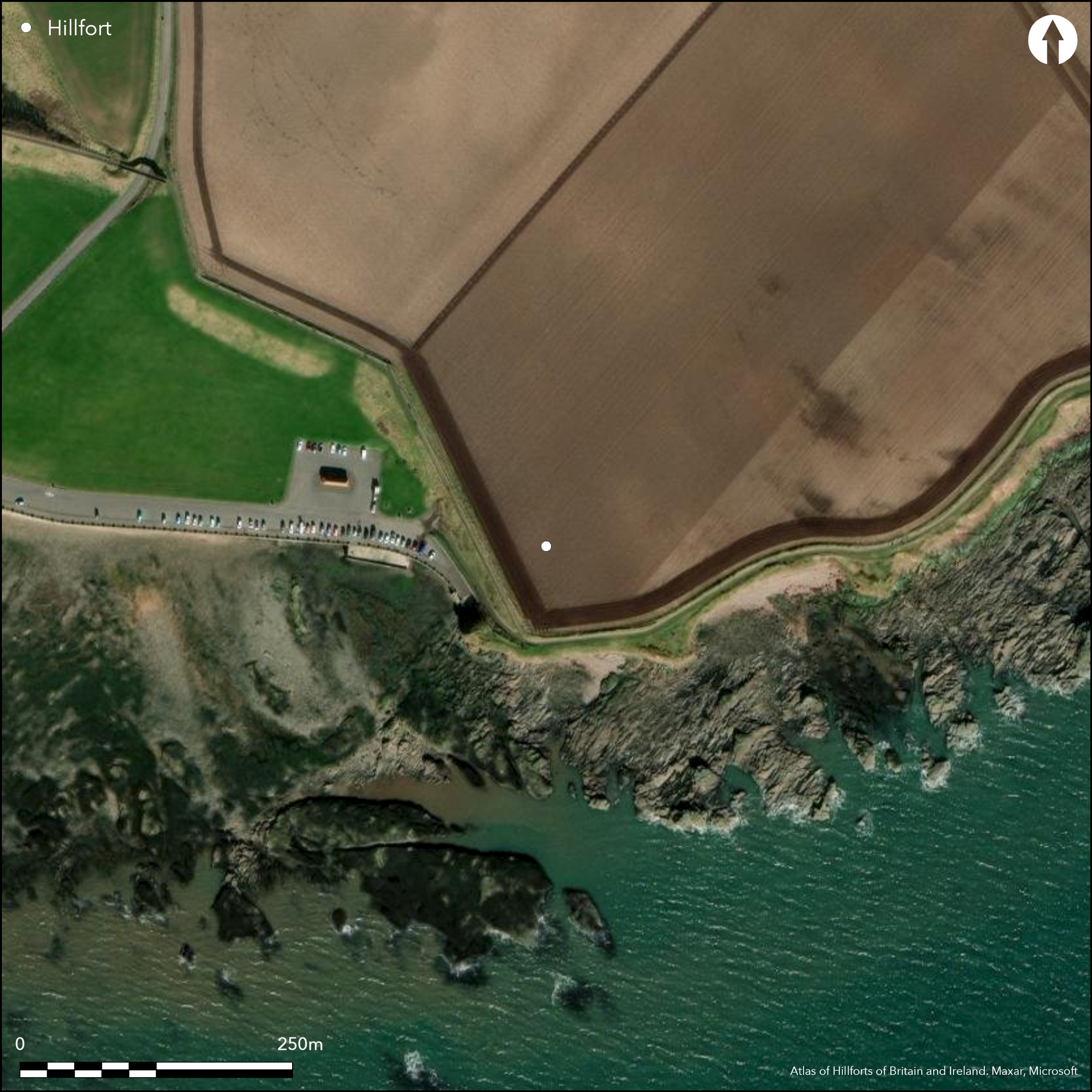
Still visible at the end of the 18th century (Stat Acct, xii, 1794, 183n), when it was noted as the burial-ground of a chapel traditionally ascribed to St Ninian, this probable promontory fort is otherwise known only from cropmarks. These reveal a ditch about 4m in breadth drawn in a shallow arc across the N and E approaches to cut off a triangular area measuring about 65m from NW to SE immediately to its rear by 45m transversely (0.16ha). Elsewhere the interior is defined by an actively eroding sea cliff on the S, and a relict cliff reduced to a rocky escarpment on the W, at the foot of which is St Ninian's Well. The escarpment has been heavily modified by the construction in the 1790s of a trackway up the face of the slope, which revealed the ends of several cists (Stat Acct, xii, 1794, 183n). More recently another three small cists have eroded out of the cliff-edge above the sea, two of which were excavated, but empty (Benvie 1993; 1995). The interior is otherwise featureless and the position of the entrance is not known.
Citizen Science: ✗
Reliability of Data: Confirmed
Reliability of Interpretation: Confirmed
X: -284506 Y: 7670887 (EPSG: 3857)
Longitude: -2.5557570042100157 Latitude: 56.56085977723116 (EPSG:4326)
Country: Scotland
Current County or Unitary Authority: Angus
Historic County: Angus
Current Parish/Community/Council/Townland: Arbroath And St Vigeans
None
| Extant | ✗ |
| Cropmark | ✓ |
| Likely Destroyed | ✗ |
None
| Woodland | ✗ |
| Commercial Forestry Plantation | ✗ |
| Parkland | ✗ |
| Pasture (Grazing) | ✗ |
| Arable | ✗ |
| Scrub/Bracken | ✗ |
| Bare Outcrop | ✗ |
| Heather/Moorland | ✗ |
| Heath | ✗ |
| Built-up | ✗ |
| Coastal Grassland | ✓ |
| Other | ✗ |
None
| Contour Fort | ✗ |
| Partial Contour Fort | ✗ |
| Promontory Fort | ✓ |
| Hillslope Fort | ✗ |
| Level Terrain Fort | ✗ |
| Marsh Fort | ✗ |
| Multiple Enclosure Fort | ✗ |
| Hilltop | ✗ |
| Coastal Promontory | ✓ |
| Inland Promontory | ✗ |
| Valley Bottom | ✗ |
| Knoll/Hillock/Outcrop | ✗ |
| Ridge | ✗ |
| Cliff/Plateau-edge/Scarp | ✗ |
| Hillslope | ✗ |
| Lowland | ✗ |
| Spur | ✗ |
Dominant Topographic Feature: None
| North | ✗ |
| Northeast | ✗ |
| East | ✗ |
| Southeast | ✗ |
| South | ✗ |
| Southwest | ✗ |
| West | ✗ |
| Northwest | ✗ |
| Level | ✓ |
Altitude: 15.0m
N/A
Analogy with other sites would suggest that the long cist cemetery has been inserted into an earlier promontory enclosure, though there is a possibility that the ditch is deliberately constructed as a monastic vallum
Reliability: D - None
| Pre 1200BC | ✗ |
| 1200BC - 800BC | ✗ |
| 800BC - 400BC | ✗ |
| 400BC - AD50 | ✗ |
| AD50 - AD400 | ✗ |
| AD400 - AD 800 | ✓ |
| Post AD800 | ✗ |
| Unknown | ✓ |
| Pre Hillfort: | None |
| Post Hillfort: | Long cist cemetery, eroding in recent times, and chapel |
None
| 1st Identified Written Reference (1794): | Cists found and noted as the burial-ground (Stat Acct, xii, 1794, 183n) |
| 1st Identified Map Depiction (1859): | Annotated 'Supposed Site of St Ninian's Chapel and Grave Yard' on the 1st edition OS 25-inch map (Forfar 1865, sheet 46.16) |
| Other (1958): | Visited by the OS |
| Other (1988): | Photographed by RCAHMS Aerial Survey Programme |
| Excavation (1993): | Three small long cists discovered (Benvie, 1993; 1995) |
Featureless, but traditionally the site of a chapel (Stat Acct, xii, 1794, 183n)
St Ninian's Well lies at the foot of the escarpment on the W
| None | ✓ |
| Spring | ✗ |
| Stream | ✗ |
| Pool | ✗ |
| Flush | ✗ |
| Well | ✗ |
| Other | ✗ |
None
| No Known Features | ✓ |
| Round Stone Structures | ✗ |
| Rectangular Stone Structures | ✗ |
| Curvilinear Platforms | ✗ |
| Other Roundhouse Evidence | ✗ |
| Pits | ✗ |
| Quarry Hollows | ✗ |
| Other | ✗ |
Cists found in the late 18th century (Stat Acct, xii, 1794, 183n), and others in 1993 (Benvie 1993; 1995)
| No Known Excavation | ✗ |
| Pits | ✗ |
| Postholes | ✗ |
| Roundhouses | ✗ |
| Rectangular Structures | ✗ |
| Roads/Tracks | ✗ |
| Quarry Hollows | ✗ |
| Other | ✓ |
| Nothing Found | ✗ |
None
| No Known Geophysics | ✓ |
| Pits | ✗ |
| Roundhouses | ✗ |
| Rectangular Structures | ✗ |
| Roads/Tracks | ✗ |
| Quarry Hollows | ✗ |
| Other | ✗ |
| Nothing Found | ✗ |
None
| No Known Finds | ✓ |
| Pottery | ✗ |
| Metal | ✗ |
| Metalworking | ✗ |
| Human Bones | ✗ |
| Animal Bones | ✗ |
| Lithics | ✗ |
| Environmental | ✗ |
| Other | ✗ |
NO APPARENT FEATURES
| APs Not Checked | ✗ |
| None | ✓ |
| Roundhouses | ✗ |
| Rectangular Structures | ✗ |
| Pits | ✗ |
| Postholes | ✗ |
| Roads/Tracks | ✗ |
| Other | ✗ |
None known
| 0: | None |
| 2: | None known |
Guard Chambers: ✗
Chevaux de Frise: ✗
Single ditch, presumably with an upcast rampart
| Area 1: | 0.16ha. |
| Total: | 0.16ha. |
Total Footprint Area: Noneha.
None
| ✗ | None |
| ✗ | None |
| NE Quadrant: | 1 |
| SE Quadrant: | 0 |
| SW Quadrant: | 0 |
| NW Quadrant: | 0 |
| Total: | 1 |
| Partial Univallate | ✓ |
| Univallate | ✗ |
| Partial Bivallate | ✗ |
| Bivallate | ✗ |
| Partial Multivallate | ✗ |
| Multivallate | ✗ |
| Unknown | ✗ |
| Partial Univallate | ✗ |
| Univallate | ✗ |
| Partial Bivallate | ✗ |
| Bivallate | ✗ |
| Partial Multivallate | ✗ |
| Multivallate | ✗ |
None
| None | ✓ |
| Earthen Bank | ✗ |
| Stone Wall | ✗ |
| Rubble | ✗ |
| Wall-walk | ✗ |
| Evidence of Timber | ✗ |
| Vitrification | ✗ |
| Other Burning | ✗ |
| Palisade | ✗ |
| Counter Scarp Bank | ✗ |
| Berm | ✗ |
| Unfinished | ✗ |
| Other | ✗ |
None
| None | ✗ |
| Earthen Bank | ✗ |
| Stone Wall | ✗ |
| Murus Duplex | ✗ |
| Timber-framed | ✗ |
| Timber-laced | ✗ |
| Vitrification | ✗ |
| Other Burning | ✗ |
| Palisade | ✗ |
| Counter Scarp Bank | ✗ |
| Berm | ✗ |
| Unfinished | ✗ |
| No Known Excavation | ✓ |
| Other | ✗ |
| ✗ | None |
| ✓ | Revealed by cropmarks |
Number of Ditches: 1
| ✗ | None |
Benvie, R (1993) 'Whiting Ness (Arbroath & St Vigeans parish): stone drain'. Disc Exc Scot (1993), 94
Benvie, R. (1995) 'Whiting Ness (Arbroath & St Vigeans parish), stone drain'. Disc Exc Scot (1995), 92
Stat Acct (date) Statistical Account of Scotland: Drawn up from the Communications of the Ministers of the Different Parishes (Sinclair, J ed), 1791-99 OSA
Atlas of Hillforts:
Wikidata:
This work is licensed under CC BY-SA 4.0![]()
![]()
![]() and should be cited as:
and should be cited as:
Lock, Gary and Ralston, Ian. 2024. Atlas of Hillforts of Britain and Ireland. Available at: https://hillforts.arch.ox.ac.uk
Document Version 1.1