Satellite Imagery
Satellite Imagery
HER: Aberdeenshire Historic Environment Record NO88SE0007 (None)
NMR: NO 88 SE 11 (36992)
SM: 986
NGR: NO 8812 8384
X: 388128 Y: 783842 (OSGB36)
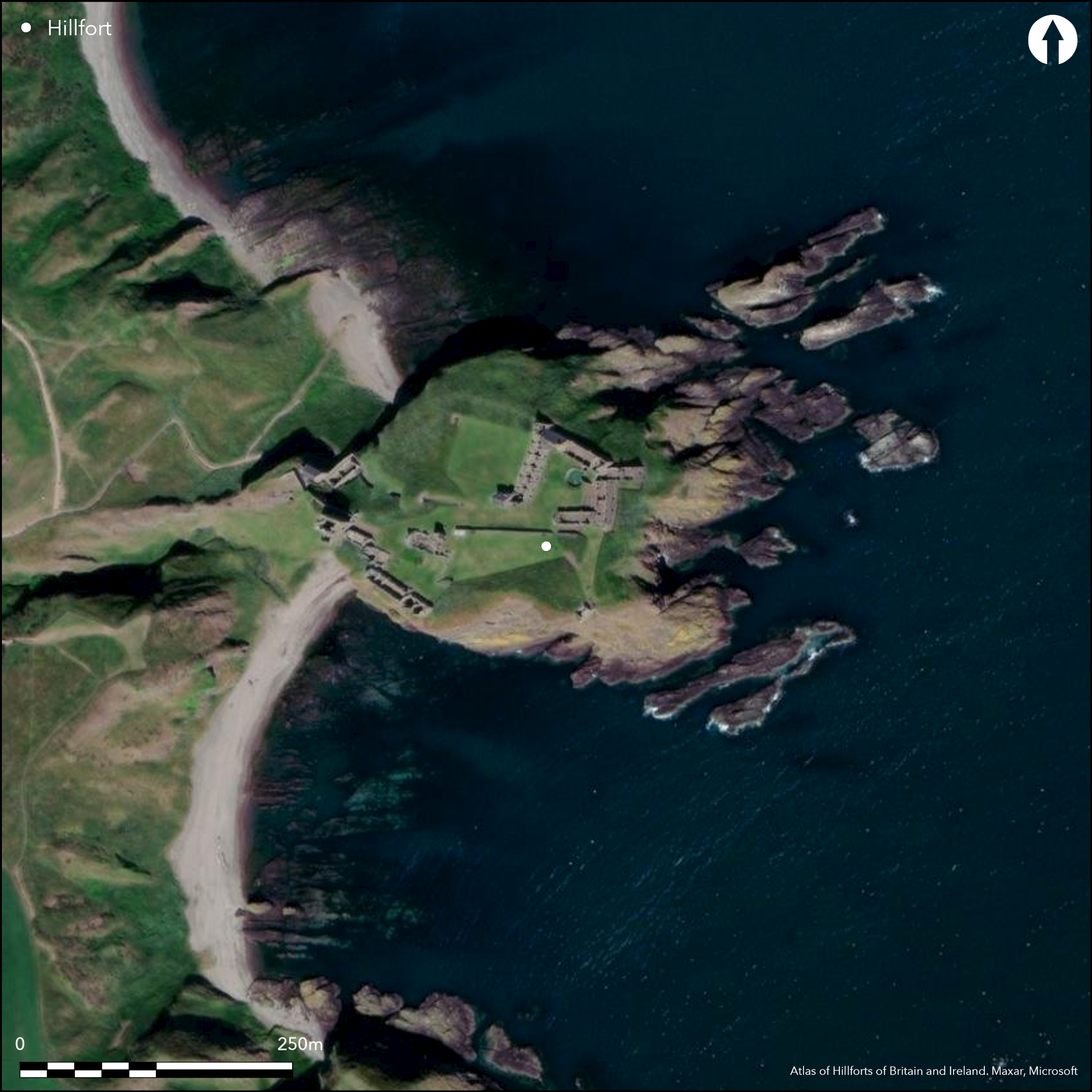
Entries in the Annals of Ulster for the years AD 680 and AD 693, in both cases referencing sieges of Dun Foither or Fother have been associated on the strength of place-name evidence with the spectacular coastal promontory occupied by Dunottar Castle (Watson 1926, 510-11); a later reference in the Scottish Chronicle alleges the destruction of Opidum Fother by the Vikings (Alcock and Alcock 1992, 267). In 1984 this led Leslie Alcock to excavate an evaluation trench across the earthworks at the NW margin of the promontory. This failed to locate any deposits or artefacts dating from before the late 12th century, and while accepting that the evidence of a small evaluation trench on a promontory that extends to some 1.5ha was hardly conclusive, Alcock went on to consider the possibility that the identification with this promontory was skewed by the presence of the medieval castle. Rather than Dunottar Castle, he raised the possibility that the Annals were referring to the Bowduns promontory, on the opposite side of Castlehaven Bay, overlooking Dunnicaer with its Pictish symbol stones (Atlas No. 3111), which he suggested was an early medieval cult focus. The Bowduns promontory is linked to the mainland by a broad natural gully across a narrow isthmus, and a bank in the bottom of this gully is annotated 'Rampart' in Gothic script on the 1st edition OS 25-inch map (Kincardine 1868, sheet 17.8), an attribution that was omitted from later editions of the maps. Inspection by both the OS and RCAHMS investigators of this bank and a bank extending round the margin of the headland to enclose about 2.6ha suggests they are no more than agricultural boundaries; indeed, the whole of the summit area of the promontory has been cultivated. Comparatively speaking, the rather more spectacular, and naturally defensible promontory occupied by the castle, linked to the coastal cliffs by no more than a narrow spine of rock, is a far more likely position for an early medieval stronghold, and it would be extraordinary if such a site was not occupied in preference to Bowduns.
Citizen Science: ✗
Reliability of Data: Unconfirmed
Reliability of Interpretation: Unconfirmed
X: -244541 Y: 7749039 (EPSG: 3857)
Longitude: -2.1967529276084066 Latitude: 56.945751376817206 (EPSG:4326)
Country: Scotland
Current County or Unitary Authority: Aberdeenshire
Historic County: Kincardineshire
Current Parish/Community/Council/Townland: Dunnottar
None
| Extant | ✗ |
| Cropmark | ✗ |
| Likely Destroyed | ✓ |
None
| Woodland | ✗ |
| Commercial Forestry Plantation | ✗ |
| Parkland | ✓ |
| Pasture (Grazing) | ✗ |
| Arable | ✗ |
| Scrub/Bracken | ✗ |
| Bare Outcrop | ✗ |
| Heather/Moorland | ✗ |
| Heath | ✗ |
| Built-up | ✓ |
| Coastal Grassland | ✗ |
| Other | ✗ |
None
| Contour Fort | ✗ |
| Partial Contour Fort | ✗ |
| Promontory Fort | ✓ |
| Hillslope Fort | ✗ |
| Level Terrain Fort | ✗ |
| Marsh Fort | ✗ |
| Multiple Enclosure Fort | ✗ |
| Hilltop | ✗ |
| Coastal Promontory | ✓ |
| Inland Promontory | ✗ |
| Valley Bottom | ✗ |
| Knoll/Hillock/Outcrop | ✗ |
| Ridge | ✗ |
| Cliff/Plateau-edge/Scarp | ✗ |
| Hillslope | ✗ |
| Lowland | ✗ |
| Spur | ✗ |
Dominant Topographic Feature: None
| North | ✗ |
| Northeast | ✗ |
| East | ✗ |
| Southeast | ✗ |
| South | ✗ |
| Southwest | ✗ |
| West | ✗ |
| Northwest | ✗ |
| Level | ✓ |
Altitude: 30.0m
N/A
Entries in the Annals of Ulster and the Scottish Chronicle suggest the presence of an early medieval stronghold beneath the medieval castle.
Reliability: D - None
| Pre 1200BC | ✗ |
| 1200BC - 800BC | ✗ |
| 800BC - 400BC | ✗ |
| 400BC - AD50 | ✗ |
| AD50 - AD400 | ✗ |
| AD400 - AD 800 | ✓ |
| Post AD800 | ✗ |
| Unknown | ✗ |
| Pre Hillfort: | None |
| Post Hillfort: | None |
| Other: | Documentary |
RCAHMS hold an extensive collection of aerial photographs and other records relating to the castle, not otherwise referenced here.
| 1st Identified Written Reference (1926): | Place-name identification (Watson 1926, 510-11) |
| Earthwork Survey (1930): | Plan of the castle by Pat Watson (RCAHMS KCD 28/1 & DP160547) |
| Other (1969): | Resurveyed at 1:2500 by the OS |
| Other (1970): | Scheduled |
| Excavation (1984): | Evaluation by Leslie Alcock (Foster et al 1985; Alcock and Alcock 1992, 267-82) |
Occupied by the castle and its works
The Castle has a well, but there is no reason to believe that this is an earlier feature
| None | ✓ |
| Spring | ✗ |
| Stream | ✗ |
| Pool | ✗ |
| Flush | ✗ |
| Well | ✗ |
| Other | ✗ |
None
| No Known Features | ✓ |
| Round Stone Structures | ✗ |
| Rectangular Stone Structures | ✗ |
| Curvilinear Platforms | ✗ |
| Other Roundhouse Evidence | ✗ |
| Pits | ✗ |
| Quarry Hollows | ✗ |
| Other | ✗ |
None
| No Known Excavation | ✗ |
| Pits | ✗ |
| Postholes | ✗ |
| Roundhouses | ✗ |
| Rectangular Structures | ✗ |
| Roads/Tracks | ✗ |
| Quarry Hollows | ✗ |
| Other | ✗ |
| Nothing Found | ✓ |
None
| No Known Geophysics | ✓ |
| Pits | ✗ |
| Roundhouses | ✗ |
| Rectangular Structures | ✗ |
| Roads/Tracks | ✗ |
| Quarry Hollows | ✗ |
| Other | ✗ |
| Nothing Found | ✗ |
None
| No Known Finds | ✓ |
| Pottery | ✗ |
| Metal | ✗ |
| Metalworking | ✗ |
| Human Bones | ✗ |
| Animal Bones | ✗ |
| Lithics | ✗ |
| Environmental | ✗ |
| Other | ✗ |
NO APPARENT FEATURES
| APs Not Checked | ✗ |
| None | ✓ |
| Roundhouses | ✗ |
| Rectangular Structures | ✗ |
| Pits | ✗ |
| Postholes | ✗ |
| Roads/Tracks | ✗ |
| Other | ✗ |
See main summary
| 0: | None |
| 2: | Presumably via the rock spine on the W |
Guard Chambers: ✗
Chevaux de Frise: ✗
None recorded
| Area 1: | Noneha. |
| Total: | Noneha. |
Total Footprint Area: 1.5ha.
None
| ✗ | This measurement includes the grass-grown upper parts of the promontory, but not the bare rock going down to the sea on the E |
| ✗ | Unknown |
| NE Quadrant: | 0 |
| SE Quadrant: | 0 |
| SW Quadrant: | 0 |
| NW Quadrant: | 0 |
| Total: | 0 |
| Partial Univallate | ✗ |
| Univallate | ✗ |
| Partial Bivallate | ✗ |
| Bivallate | ✗ |
| Partial Multivallate | ✗ |
| Multivallate | ✗ |
| Unknown | ✓ |
| Partial Univallate | ✗ |
| Univallate | ✗ |
| Partial Bivallate | ✗ |
| Bivallate | ✗ |
| Partial Multivallate | ✗ |
| Multivallate | ✗ |
None
| None | ✓ |
| Earthen Bank | ✗ |
| Stone Wall | ✗ |
| Rubble | ✗ |
| Wall-walk | ✗ |
| Evidence of Timber | ✗ |
| Vitrification | ✗ |
| Other Burning | ✗ |
| Palisade | ✗ |
| Counter Scarp Bank | ✗ |
| Berm | ✗ |
| Unfinished | ✗ |
| Other | ✗ |
None
| None | ✓ |
| Earthen Bank | ✗ |
| Stone Wall | ✗ |
| Murus Duplex | ✗ |
| Timber-framed | ✗ |
| Timber-laced | ✗ |
| Vitrification | ✗ |
| Other Burning | ✗ |
| Palisade | ✗ |
| Counter Scarp Bank | ✗ |
| Berm | ✗ |
| Unfinished | ✗ |
| No Known Excavation | ✗ |
| Other | ✗ |
| ✗ | None |
| ✗ | None |
Number of Ditches: None
| ✗ | None |
Alcock, L (1981) 'Early historic fortifications in Scotland'. In Guilbert, G (ed.) Hill-fort studies: essays for A H A Hogg. Leicester
Alcock and Alcock, L and E A (1992) 'Reconnaissance excavations on Early Historic fortifications and other royal sites in Scotland, 1974-84; A, Excavations and other fieldwork at Forteviot, Perthshire, 1981; B, Excavations at Urquhart Castle, Inverness-shire, 1983; C, Excavations at Dunnottar, Kincardineshire, 1984'. Proc Soc Antiq Scot 122 (1992), 215-87
Foster, Driscoll and Alcock, S M, S T and L. (1985) Excavations at Urquhart and Dunnottar Castles, 1983 and 1984: interim reports. Glasgow
Atlas of Hillforts:
Wikidata:
This work is licensed under CC BY-SA 4.0![]()
![]()
![]() and should be cited as:
and should be cited as:
Lock, Gary and Ralston, Ian. 2024. Atlas of Hillforts of Britain and Ireland. Available at: https://hillforts.arch.ox.ac.uk
Document Version 1.1