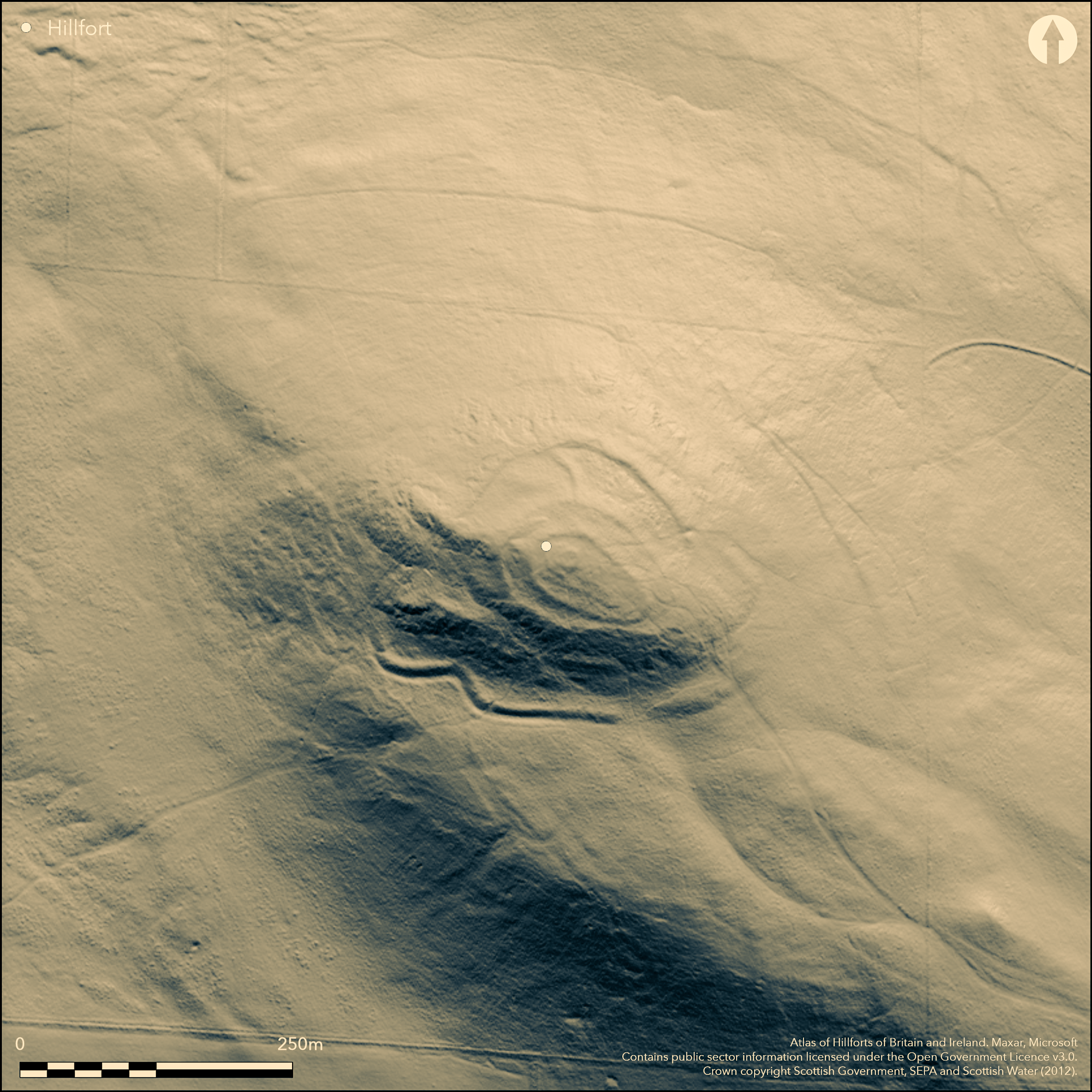
LiDAR 1m DTM Hillshade

Satellite Imagery
LiDAR 1m DTM Hillshade
Satellite Imagery
Scroll left/right to view further images.
HER: Fife Council None (None)
NMR: NO 20 NW 20 (29881)
SM: 810
NGR: NO 2440 0620
X: 324400 Y: 706200 (OSGB36)
This fort occupies East Lomond Hill, a distinctive conical summit that commands extensive views across Fife. At least three lines of defence can be identified, but it would be unwise to assume that all are part of a contemporary scheme; indeed, there are hints that at least two periods of construction are represented in the outermost line. At its core lies a pear-shaped enclosure, measuring about 60m from NW to SE by a maximum of 31m transversely towards its NW end within a rampart reduced to a mound of rubble; the only feature visible within its interior is a grass-grown cairn some 13m in diameter by 1m in height. This inner enclosure is also enclosed by a second rampart, now little more than a stony scarp enclosing about 0.34ha, while yet another rampart encircles the NW and NE quarters lower down the slope, according to the plan surveyed by RCAHMS investigators in 1925, obliquely mounting the slope on the E to meet the second rampart and also linked by a rampart dropping down the slope on the N; the sequence of construction at the junction on the E is uncertain, as indeed its course on the southern flank of the summit, where the plan shows a series of terraces dropping down the slope above a massive rampart with an external ditch set at the foot of the slope. A notable feature of this outer defence is a dogleg on the SW, where it turns sharply down the slope towards the foot of the outcrops that protect the W side; oblique aerial photographs, however, reveal a faint scar traversing the slope from this dogleg, apparently heading for the lower rampart on the NE side, and possibly indicating an earlier line of enclosure on a far larger scale, perhaps taking in as much as 1.6ha, though in 1925 RCAHMS also noted several other terraces lower down the NE flank, two of which were not shown on the plan but can be seen on satellite imagery another 55m down the slope on the NE. A broad gap in this outer defence on the SE, on the line of a trackway that can be climbing the slope below, is possibly an entrance. Two hollow glass beads, a mould for small ingots and a slab bearing the incised outline of a bull have been found in the fort; in the course of the survey in 1925 RCAHMS investigators noted bloomery waste on a terrace on the SW.
Citizen Science: ✗
Reliability of Data: Confirmed
Reliability of Interpretation: Confirmed
X: -358606 Y: 7606811 (EPSG: 3857)
Longitude: -3.2214102547949306 Latitude: 56.24234371801503 (EPSG:4326)
Country: Scotland
Current County or Unitary Authority: Fife
Historic County: Fife
Current Parish/Community/Council/Townland: Falkland
None
Condition:| Extant | ✓ |
| Cropmark | ✗ |
| Likely Destroyed | ✗ |
None
Current Use:| Woodland | ✗ |
| Commercial Forestry Plantation | ✗ |
| Parkland | ✗ |
| Pasture (Grazing) | ✓ |
| Arable | ✗ |
| Scrub/Bracken | ✗ |
| Bare Outcrop | ✗ |
| Heather/Moorland | ✓ |
| Heath | ✗ |
| Built-up | ✗ |
| Coastal Grassland | ✗ |
| Other | ✗ |
None
Type:| Contour Fort | ✓ |
| Partial Contour Fort | ✗ |
| Promontory Fort | ✗ |
| Hillslope Fort | ✗ |
| Level Terrain Fort | ✗ |
| Marsh Fort | ✗ |
| Multiple Enclosure Fort | ✓ |
| Hilltop | ✓ |
| Coastal Promontory | ✗ |
| Inland Promontory | ✗ |
| Valley Bottom | ✗ |
| Knoll/Hillock/Outcrop | ✗ |
| Ridge | ✗ |
| Cliff/Plateau-edge/Scarp | ✗ |
| Hillslope | ✗ |
| Lowland | ✗ |
| Spur | ✗ |
Dominant Topographic Feature: Very prominent conical feature commanding extensive views
| North | ✗ |
| Northeast | ✗ |
| East | ✗ |
| Southeast | ✗ |
| South | ✗ |
| Southwest | ✗ |
| West | ✗ |
| Northwest | ✗ |
| Level | ✓ |
Altitude: 445.0m
N/A
The presence of the incised rock carving of a bull is assumed to indicate a period of occupation in the early medieval period, but the remains may encompass earlier occupations
Reliability: D - None
Principal Activity:| Pre 1200BC | ✗ |
| 1200BC - 800BC | ✗ |
| 800BC - 400BC | ✗ |
| 400BC - AD50 | ✗ |
| AD50 - AD400 | ✗ |
| AD400 - AD 800 | ✓ |
| Post AD800 | ✗ |
| Unknown | ✓ |
| Pre Hillfort: | A cairn stands on the summit and a cupmarked stone has been identified amongst the rubble |
| Post Hillfort: | None |
| Artefactual: | Incised bull on a small slab |
RCAHMS holds an extensive collection of aerial photographs
| 1st Identified Written Reference (1792): | Noted (Stat Acct, iv, 1792, 440) |
| Other (1829): | Description (Miller 1857, 33-4) |
| 1st Identified Map Depiction (1854): | Annotated Fort on the 1st edition OS 6-inch map (Fife 1856, sheet 16) |
| Other (1920): | Pictish symbol stone found (Corrie 1926, 32-4; RCAHMS 1933, 145, no.248) |
| Earthwork Survey (1925): | Plan and description; two glass beads and a spindle whorl found (RCAHMS 1933, 143-144, no. 244, fig 143; Corrie 1926, 32) |
| Other (1931): | Revisited by RCAHMS (RCAHMS 1933, 143-144, no. 244, fig 143) |
| Other (1936): | Scheduled |
| Other (1951): | Visited for RCAHMS Survey of Marginal Lands (Feachem 1963, 125) |
| Other (1968): | Resurveyed by the OS at 1:2500 |
| Other (1978): | Cup and ringmarked rock identified (Kenworthy 1978) |
| Other (1980): | Chert core found |
| Other (2014): | Re-Scheduled |
Featureless
None
Source:| None | ✓ |
| Spring | ✗ |
| Stream | ✗ |
| Pool | ✗ |
| Flush | ✗ |
| Well | ✗ |
| Other | ✗ |
None
Interior Features (Surface):| No Known Features | ✓ |
| Round Stone Structures | ✗ |
| Rectangular Stone Structures | ✗ |
| Curvilinear Platforms | ✗ |
| Other Roundhouse Evidence | ✗ |
| Pits | ✗ |
| Quarry Hollows | ✗ |
| Other | ✗ |
None
Interior Features (Excavation):| No Known Excavation | ✓ |
| Pits | ✗ |
| Postholes | ✗ |
| Roundhouses | ✗ |
| Rectangular Structures | ✗ |
| Roads/Tracks | ✗ |
| Quarry Hollows | ✗ |
| Other | ✗ |
| Nothing Found | ✗ |
None
Interior Features (Geophysics):| No Known Geophysics | ✓ |
| Pits | ✗ |
| Roundhouses | ✗ |
| Rectangular Structures | ✗ |
| Roads/Tracks | ✗ |
| Quarry Hollows | ✗ |
| Other | ✗ |
| Nothing Found | ✗ |
In addition to the chert core found here in 1980, and two leaf-shaped arrowheads found on the hill in 2000 (Saville 2004), in 1925 two hollow glass beads and a mould for casting small ingots were found by John Corrie in the course of the RCAHMS survey. Bloomery waste was also noted on a terrace on the SW flank
Interior (Finds):| No Known Finds | ✓ |
| Pottery | ✗ |
| Metal | ✗ |
| Metalworking | ✓ |
| Human Bones | ✗ |
| Animal Bones | ✗ |
| Lithics | ✓ |
| Environmental | ✗ |
| Other | ✗ |
NO APPARENT FEATURES
Interior Features (Aerial):| APs Not Checked | ✗ |
| None | ✓ |
| Roundhouses | ✗ |
| Rectangular Structures | ✗ |
| Pits | ✗ |
| Postholes | ✗ |
| Roads/Tracks | ✗ |
| Other | ✗ |
See main summary
Total Number of Breaks Through Ramparts:| 1: | None |
| 2: | Broad gap on the SE but no recorded features to confirm this is an entrance |
Guard Chambers: ✗
Chevaux de Frise: ✗
A series of heavily degraded stone ramparts encircling the summit, and a massive ditch and bank around the foot of the slope on one side.
Enclosed Area:| Area 1: | 0.15ha. |
| Area 2: | 0.34ha. |
| Area 3: | 1.6ha. |
| Total: | 1.6ha. |
Total Footprint Area: 3.3ha.
None
Multi-period Enclosure System:| ✗ | The overall measurement is based on a projection of the outlying terraces on the NE round to the massive outermost rampart on the S. |
| ✓ | The precise numbers of ramparts on each quarter are uncertain |
| NE Quadrant: | 3 |
| SE Quadrant: | 4 |
| SW Quadrant: | 4 |
| NW Quadrant: | 3 |
| Total: | 4 |
| Partial Univallate | ✗ |
| Univallate | ✗ |
| Partial Bivallate | ✗ |
| Bivallate | ✗ |
| Partial Multivallate | ✗ |
| Multivallate | ✓ |
| Unknown | ✗ |
| Partial Univallate | ✗ |
| Univallate | ✗ |
| Partial Bivallate | ✓ |
| Bivallate | ✗ |
| Partial Multivallate | ✗ |
| Multivallate | ✗ |
None
Enclosing Works (Surface):| None | ✗ |
| Earthen Bank | ✓ |
| Stone Wall | ✗ |
| Rubble | ✓ |
| Wall-walk | ✗ |
| Evidence of Timber | ✗ |
| Vitrification | ✗ |
| Other Burning | ✗ |
| Palisade | ✗ |
| Counter Scarp Bank | ✗ |
| Berm | ✗ |
| Unfinished | ✗ |
| Other | ✗ |
None
Enclosing Works (Excavation):| None | ✗ |
| Earthen Bank | ✗ |
| Stone Wall | ✗ |
| Murus Duplex | ✗ |
| Timber-framed | ✗ |
| Timber-laced | ✗ |
| Vitrification | ✗ |
| Other Burning | ✗ |
| Palisade | ✗ |
| Counter Scarp Bank | ✗ |
| Berm | ✗ |
| Unfinished | ✗ |
| No Known Excavation | ✓ |
| Other | ✗ |
| ✗ | None |
| ✓ | The outermost rampart on one side |
Number of Ditches: 1
Annex:| ✗ | None |
Corrie, J M. (1926) 'Notice of (1) certain bronze implements from Dumfriesshire; and (2) a symbol stone from East Lomond Hill, Fife, recently presented to the National Museum'. Proc Soc Antiq Scot 60 (1925-6), 27-34
Feachem, R (1963) A guide to prehistoric Scotland. Batsford: London
Kenworthy, M (1978) 'Lomond Hills survey'. Disc Exc Scot (1978), 6-7
Miller, Lieut-Col. (1857) 'An inquiry respecting the site of the Battle of Mons Grampius'. Archaeol Scot 4 (1857), 19-52
RCAHMS. (1933) The Royal Commission on the Ancient and Historical Monuments and Constructions of Scotland. Eleventh report with inventory of monuments and constructions in the counties of Fife, Kinross, and Clackmannan. HMSO: Edinburgh
Saville, A (2004) 'East Lomond Hill (Falkland parish), Neolithic arrowheads'. Disc Exc Scot, New Ser, 5 (2004), 62
Stat Acct (date) Statistical Account of Scotland: Drawn up from the Communications of the Ministers of the Different Parishes (Sinclair, J ed), 1791-99
This work is licensed under CC BY-SA 4.0![]()
![]()
![]() and should be cited as:
and should be cited as:
Lock, Gary and Ralston, Ian. 2024. Atlas of Hillforts of Britain and Ireland. Available at: https://hillforts.arch.ox.ac.uk
Document Version 1.1