
LiDAR 1m DTM Hillshade
Satellite Imagery
LiDAR 1m DTM Hillshade
Satellite Imagery
Scroll left/right to view further images.
HER: Fife Council None (None)
NMR: NO 21 NW 18 (30074)
SM: None
NGR: NO 2435 1780
X: 324350 Y: 717800 (OSGB36)
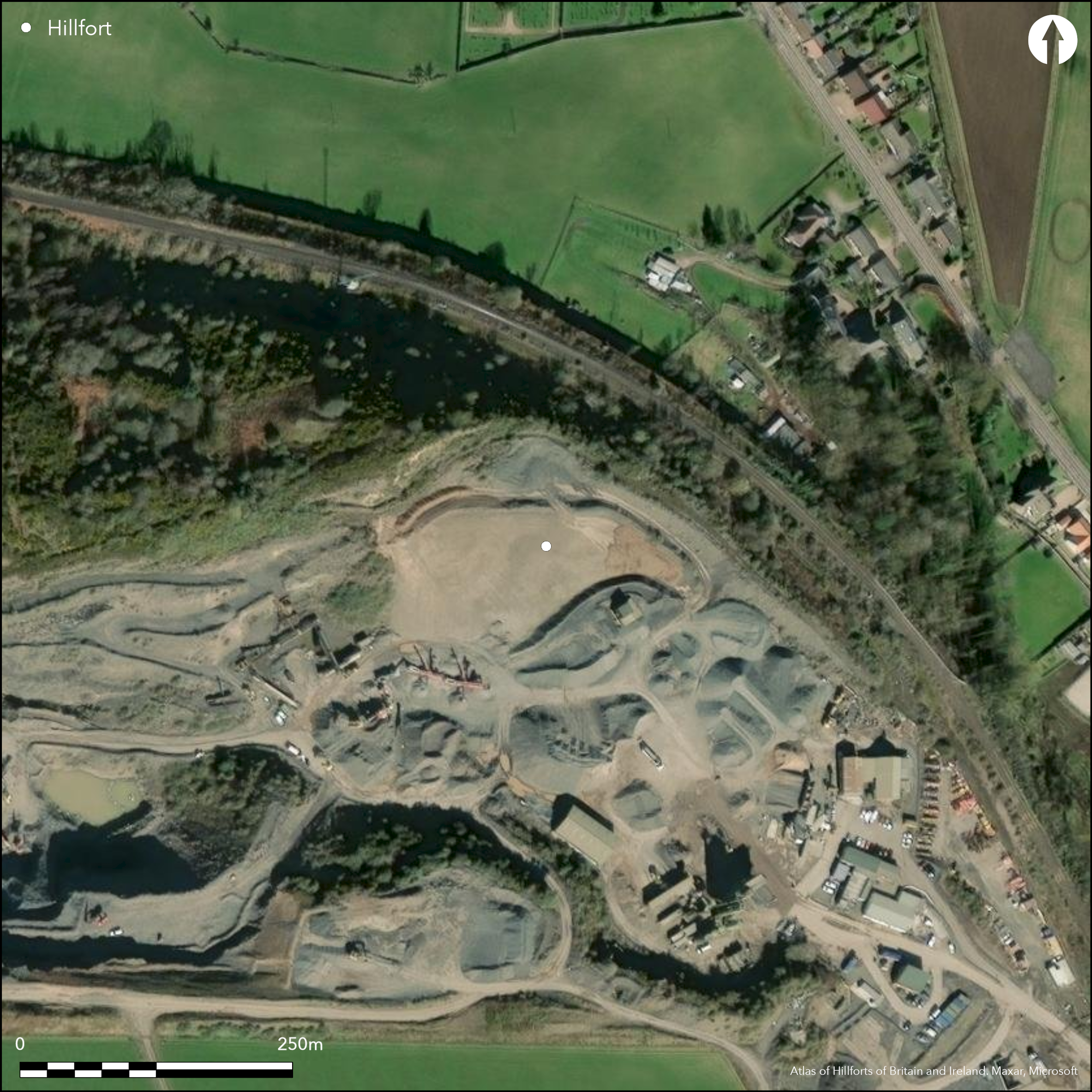
This complex fort occupied a prominent hill in the gap in the hills SE of Newburgh, but by 1970 it had been completely destroyed by quarrying. The N flank of the hill fell away in a precipice, but elsewhere the ground descended more gently in a series of terraces and was defended by a complex of ramparts. The plan drawn up by Charles Calder for the RCAHMS inventory remains the principal source for the configuration of these defences, and with modifications as a result of the excavations in 1954 and 1959-60, forms the basis for the plan accompanying the excavation report published by Joanna Close-Brooks (1986, 121, fig 3). Superficially, there appear to have been three eccentric enclosures, the outer of which is defended by three or four ramparts. The innermost enclosure occupied the summit area, which was girt with a natural rocky scarp over 4m high and measured about 73m from ESE to WNW by 27m transversely (0.18ha) within a single rampart, which proved on excavation to have been laced with timbers up to 0.3m thick, with traces of longitudinal timbers towards its rear. Two radiocarbon dates of AD 390-640 and 540-880 were obtained. A floor and a paved hearth were probably buried beneath tumble from this rampart and overlay deposits containing clay moulds of 8th-century date; other mould fragments and a silver ingot were found beneath tumble nearby. The second enclosure that is distinguishable, is roughly oval and lies eccentric to all the other lines. Its W half is clearly enough defined, looping from a point immediately outside the innermost enclosure on the cliff-edge round across a lower terrace on the SW, but its course towards the E is less certain, for though Calder drew it as a scarp swinging round below the ESE end of the innermost enclosure, across the line of the third rampart, there is little sign of it amongst the natural irregularities visible on the RAF aerial photograph. Nevertheless, it probably enclosed an area measuring in the order of 90m from E to W by at least 67m transversely (0.46ha). Faced roughly with stone, this too was apparently timber-laced, while six stones with mortar adhering to them from one cutting probably have a Roman origin; a sherd of Samian ware was also recovered from the body of the rampart. A radiocarbon date of AD 430-660 from charcoal within the rampart is indistinguishable from dates from timbers in other ramparts and led Close-Brooks to suggest this was a residual sample providing no more than a terminus post quem, but equally it may derive from rapid and successive phases of construction and destruction. The third enclosure took in a larger irregular area measuring about 115m from ESE to WNW by 70m transversely (0.68ha) within a stone faced rampart laced both transversely and longitudinally with timbers, which had also been burnt; calibrated dates dates of AD 430 to 670 and 540 to 770 was returned. A mass of burnt timbers found lying in front of this rampart on the S was possibly the remains of breastwork and appeared to be overlain by tumbled stones from an outer rampart below it, one of up to four on the W and three on the SE. Whether this is sufficient evidence to date all these outer ramparts to the early medieval period is debated by Close-Brooks. Suffice it to say that if there is an earlier fort here, as seems likely, its innermost rampart is probably followed the line of either the third rampart, or possibly the fourth rampart outside it; failure to identify earlier defences may simply be a function of the narrow trenches dug across them. There are certainly curiosities in the lines of the outer ramparts, such as a break in the fourth rampart at its S angle and the possible entrance in the gully on the S to suggest that the history of enclosure here was probably more complex than the excavations revealed.
Citizen Science: ✗
Reliability of Data: Confirmed
Reliability of Interpretation: Confirmed
X: -359066 Y: 7627712 (EPSG: 3857)
Longitude: -3.2255470065597693 Latitude: 56.3465313860972 (EPSG:4326)
Country: Scotland
Current County or Unitary Authority: Fife
Historic County: Fife
Current Parish/Community/Council/Townland: Abdie
Destroyed by quarrying
| Extant | ✗ |
| Cropmark | ✗ |
| Likely Destroyed | ✓ |
Quarry
| Woodland | ✗ |
| Commercial Forestry Plantation | ✗ |
| Parkland | ✗ |
| Pasture (Grazing) | ✗ |
| Arable | ✗ |
| Scrub/Bracken | ✗ |
| Bare Outcrop | ✗ |
| Heather/Moorland | ✗ |
| Heath | ✗ |
| Built-up | ✗ |
| Coastal Grassland | ✗ |
| Other | ✓ |
None
| Contour Fort | ✓ |
| Partial Contour Fort | ✗ |
| Promontory Fort | ✗ |
| Hillslope Fort | ✗ |
| Level Terrain Fort | ✗ |
| Marsh Fort | ✗ |
| Multiple Enclosure Fort | ✗ |
| Hilltop | ✓ |
| Coastal Promontory | ✗ |
| Inland Promontory | ✗ |
| Valley Bottom | ✗ |
| Knoll/Hillock/Outcrop | ✗ |
| Ridge | ✗ |
| Cliff/Plateau-edge/Scarp | ✗ |
| Hillslope | ✗ |
| Lowland | ✗ |
| Spur | ✗ |
Dominant Topographic Feature: None
| North | ✗ |
| Northeast | ✗ |
| East | ✗ |
| Southeast | ✗ |
| South | ✗ |
| Southwest | ✗ |
| West | ✗ |
| Northwest | ✗ |
| Level | ✓ |
Altitude: 119.0m
N/A
Early medieval finds include a small metal disc decorated in hanging-bowl style, two sherds of E-ware, a sherd of 5th century glass, a glass bead, a silver ingot, and a group of clay moulds for casting penannular brooches and other objects. Several objects of Roman date were recovered, and others that are likely to be Iron Age, but these need not imply either occupation or fortification, despite the likelihood that the defences incorporated elements of an earlier fort.
Reliability: D - None
| Pre 1200BC | ✗ |
| 1200BC - 800BC | ✗ |
| 800BC - 400BC | ✗ |
| 400BC - AD50 | ✗ |
| AD50 - AD400 | ✗ |
| AD400 - AD 800 | ✓ |
| Post AD800 | ✗ |
| Unknown | ✓ |
| Pre Hillfort: | A carved stone ball was apparently found here (Laing 1876, 8-9) and in the course of the later excavations a pit containing Neolithic pottery was found on the summit area, and elsewhere a scatter of other pottery and several stone tools. There were also two sherds possibly from the base of a Beaker. |
| Post Hillfort: | Destroyed |
| Artefactual: | None |
| C14: | Five dates spanning AD 390-880 |
A remarkable aerial photograph was taken by the in 1932 by the RAF for the RCAHMS County Inventory and is included with the excavation archive in the holdings of RCAHMS
| 1st Identified Written Reference (1657): | Noted by Sir James Balfour of Denmilne and Kinnaird, Lord Lyon King at Arms (d1657) in an undated manuscript (Close-Brooks 1986, 119; Sibbald 1711, 8) |
| Other (1836): | Noted (NSA, 9, Fife, 49) |
| 1st Identified Map Depiction (1854): | Annotated Fort on the 1st edition OS 6-inch map (Fife 1856, sheet 9) |
| Earthwork Survey (1876): | Plan and description by Alexander Laing; claims burning evident in a footnote (1876, 7-9) |
| Other (1893): | OS 1:2500 depiction (Fifeshire 1895, sheet 6.11) |
| Earthwork Survey (1925): | Plan and description (RCAHMS 1933, 4-6, no.5, fig 71; RCAHMS FID 23/1-3) |
| Other (1951): | Visited for RCAHMS Survey of Marginal Lands |
| Excavation (1954): | By P R Ritchie (1954; Close-Brooks 1986; 1987) |
| Excavation (1959): | By R Hope-Simpson (Cruden 1959; Close-Brooks 1986; 1987) |
| Excavation (1960): | By R Hope-Simpson (Cruden 1960; Close-Brooks 1986; 1987) |
| Other (1970): | Visit by the OS confirms complete destruction |
Little evidence found in excavation, other than what Close-Brooks argued had probably been a rectangular building with a hearth on the summit
A small sump known as The Bluidy Well that collected water
| None | ✗ |
| Spring | ✗ |
| Stream | ✗ |
| Pool | ✗ |
| Flush | ✗ |
| Well | ✗ |
| Other | ✓ |
None
| No Known Features | ✓ |
| Round Stone Structures | ✗ |
| Rectangular Stone Structures | ✗ |
| Curvilinear Platforms | ✗ |
| Other Roundhouse Evidence | ✗ |
| Pits | ✗ |
| Quarry Hollows | ✗ |
| Other | ✗ |
Hearth and a pivot stone for a door
| No Known Excavation | ✗ |
| Pits | ✗ |
| Postholes | ✓ |
| Roundhouses | ✗ |
| Rectangular Structures | ✗ |
| Roads/Tracks | ✗ |
| Quarry Hollows | ✗ |
| Other | ✓ |
| Nothing Found | ✗ |
None
| No Known Geophysics | ✓ |
| Pits | ✗ |
| Roundhouses | ✗ |
| Rectangular Structures | ✗ |
| Roads/Tracks | ✗ |
| Quarry Hollows | ✗ |
| Other | ✗ |
| Nothing Found | ✗ |
Sherds of Iron Age pottery, a stone disc, a bronze ring, a shale ring and bangle fragments, a decorated clay and a quantity of iron slag, may all belong to a pre early medieval occupation. An openwork ornament and a brooch pin and a penannular brooch may be Roman Iron Age. Coarse stone tools include a grinding stone spindle whorls, a rotary quern and a saddle quern rubber. Early medieval finds include a small metal disc decorated in hanging-bowl style, two sherds of E-ware, a silver ingot, a fragment of crucible and a group of clay moulds for casting penannular brooches and other objects. A few iron objects are probably also of this date.
| No Known Finds | ✗ |
| Pottery | ✓ |
| Metal | ✓ |
| Metalworking | ✓ |
| Human Bones | ✗ |
| Animal Bones | ✓ |
| Lithics | ✓ |
| Environmental | ✗ |
| Other | ✗ |
NO APPARENT FEATURES
| APs Not Checked | ✗ |
| None | ✓ |
| Roundhouses | ✗ |
| Rectangular Structures | ✗ |
| Pits | ✗ |
| Postholes | ✗ |
| Roads/Tracks | ✗ |
| Other | ✗ |
See main summary
| 1: | None |
| 2: | No evidence of entrances through the inner enclosures |
Guard Chambers: ✗
Chevaux de Frise: ✗
| 1. Simple Gap (South): | Possible gap in the outermost rampart on the S |
Multivallate enclosure backing onto a cliff-edge and almost certainly representing a series of successive defensive schemes
| Area 1: | 0.18ha. |
| Area 2: | 0.46ha. |
| Area 3: | 0.68ha. |
| Total: | 0.68ha. |
Total Footprint Area: 1.7ha.
None
| ✓ | The overall figure is a fairly crude estimate |
| ✗ | None |
| NE Quadrant: | 0 |
| SE Quadrant: | 5 |
| SW Quadrant: | 7 |
| NW Quadrant: | 5 |
| Total: | 7 |
| Partial Univallate | ✗ |
| Univallate | ✗ |
| Partial Bivallate | ✗ |
| Bivallate | ✗ |
| Partial Multivallate | ✓ |
| Multivallate | ✗ |
| Unknown | ✗ |
| Partial Univallate | ✗ |
| Univallate | ✓ |
| Partial Bivallate | ✗ |
| Bivallate | ✗ |
| Partial Multivallate | ✗ |
| Multivallate | ✗ |
Now destroyed
| None | ✓ |
| Earthen Bank | ✓ |
| Stone Wall | ✗ |
| Rubble | ✓ |
| Wall-walk | ✗ |
| Evidence of Timber | ✗ |
| Vitrification | ✗ |
| Other Burning | ✓ |
| Palisade | ✗ |
| Counter Scarp Bank | ✗ |
| Berm | ✗ |
| Unfinished | ✗ |
| Other | ✗ |
None
| None | ✗ |
| Earthen Bank | ✗ |
| Stone Wall | ✓ |
| Murus Duplex | ✗ |
| Timber-framed | ✗ |
| Timber-laced | ✓ |
| Vitrification | ✓ |
| Other Burning | ✓ |
| Palisade | ✗ |
| Counter Scarp Bank | ✗ |
| Berm | ✗ |
| Unfinished | ✗ |
| No Known Excavation | ✗ |
| Other | ✗ |
| ✗ | None |
| ✗ | None |
Number of Ditches: None
| ✗ | None |
Butchart, R (1966) 'Clatchard Craig, near Newburgh, saddle quern, spindle whorl'. Disc Exc Scot (1966), 26-7
Close-Brooks, J (1987) 'Clatchard Craig, a Pictish hillfort in Fife'. 27-30, in Small, A The Picts: a new look at old problems. Dundee
Close-Brooks, J (1986) 'Excavations at Clatchard Craig, Fife'. Proc Soc Antiq Scot 116 (1986), 117-84
Cruden, S H (1960) 'Clatchard Craig hill-fort, Fife'. Disc Exc Scot (1960), 47
Cruden, S H (1959) 'Clatchard Craig, Fife'. Disc Exc Scot (1959), 36
Feachem, R (1963) A guide to prehistoric Scotland. Batsford: London
Kemp, C (1967) Clatchard Craig. Newburgh
Laing, A (1876) Lindores Abbey and its Burgh of Newburgh; their history and annals. Edmonston and Douglas: Edinburgh
RCAHMS (1933) The Royal Commission on the Ancient and Historical Monuments and Constructions of Scotland. Eleventh report with inventory of monuments and constructions in the counties of Fife, Kinross, and Clackmannan. Edinburgh
Ritchie, P R (1954) 'Clatchard Craig, Newburgh'. Discovery Excav Scot (1954), 9
Atlas of Hillforts:
Wikidata:
This work is licensed under CC BY-SA 4.0![]()
![]()
![]() and should be cited as:
and should be cited as:
Lock, Gary and Ralston, Ian. 2024. Atlas of Hillforts of Britain and Ireland. Available at: https://hillforts.arch.ox.ac.uk
Document Version 1.1