LiDAR 1m DTM Hillshade
Satellite Imagery
LiDAR 1m DTM Hillshade
Satellite Imagery
Scroll left/right to view further images.
HER: Fife Council None (None)
NMR: NO 30 NW 21 (31228)
SM: 807
NGR: NO 3434 0715
X: 334340 Y: 707150 (OSGB36)
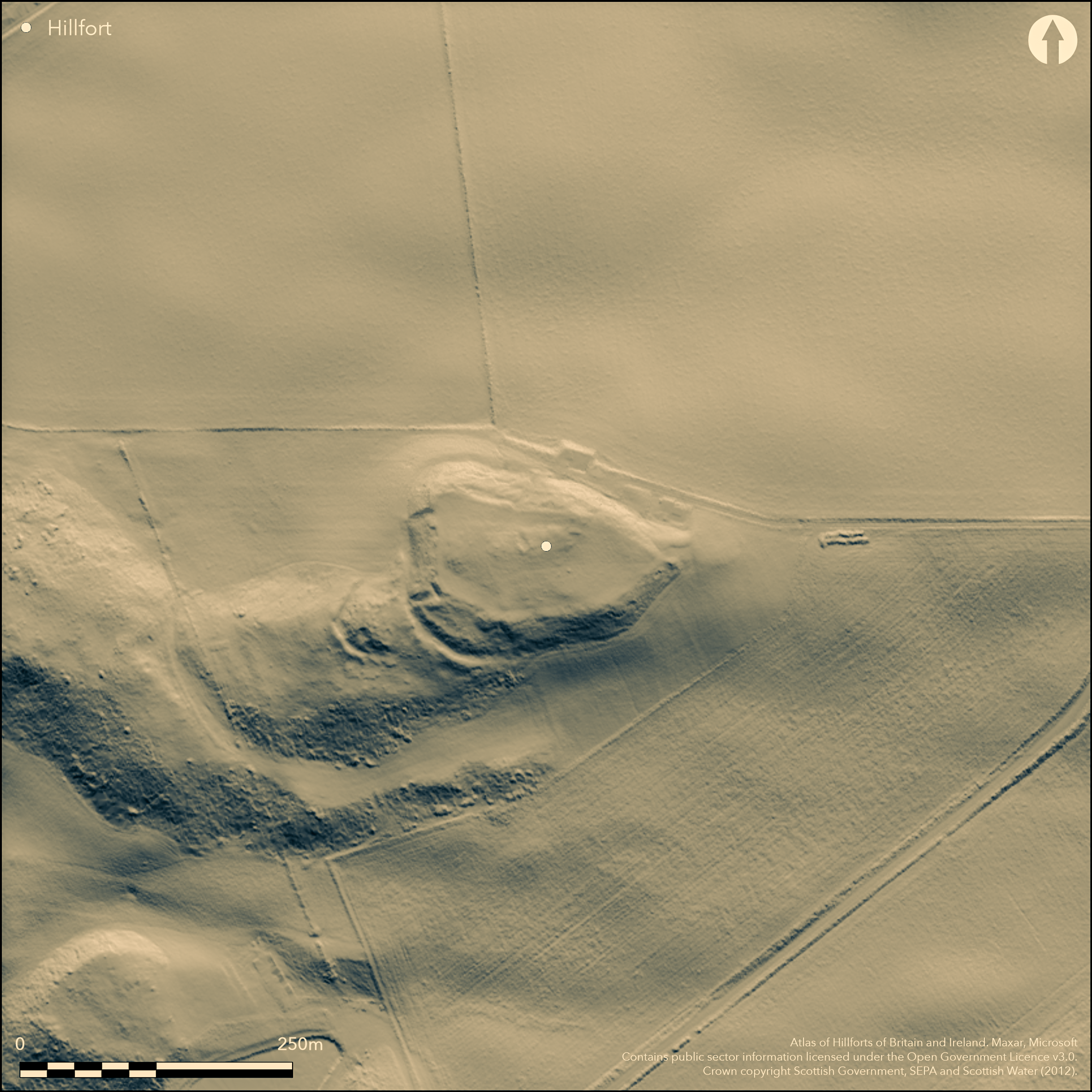
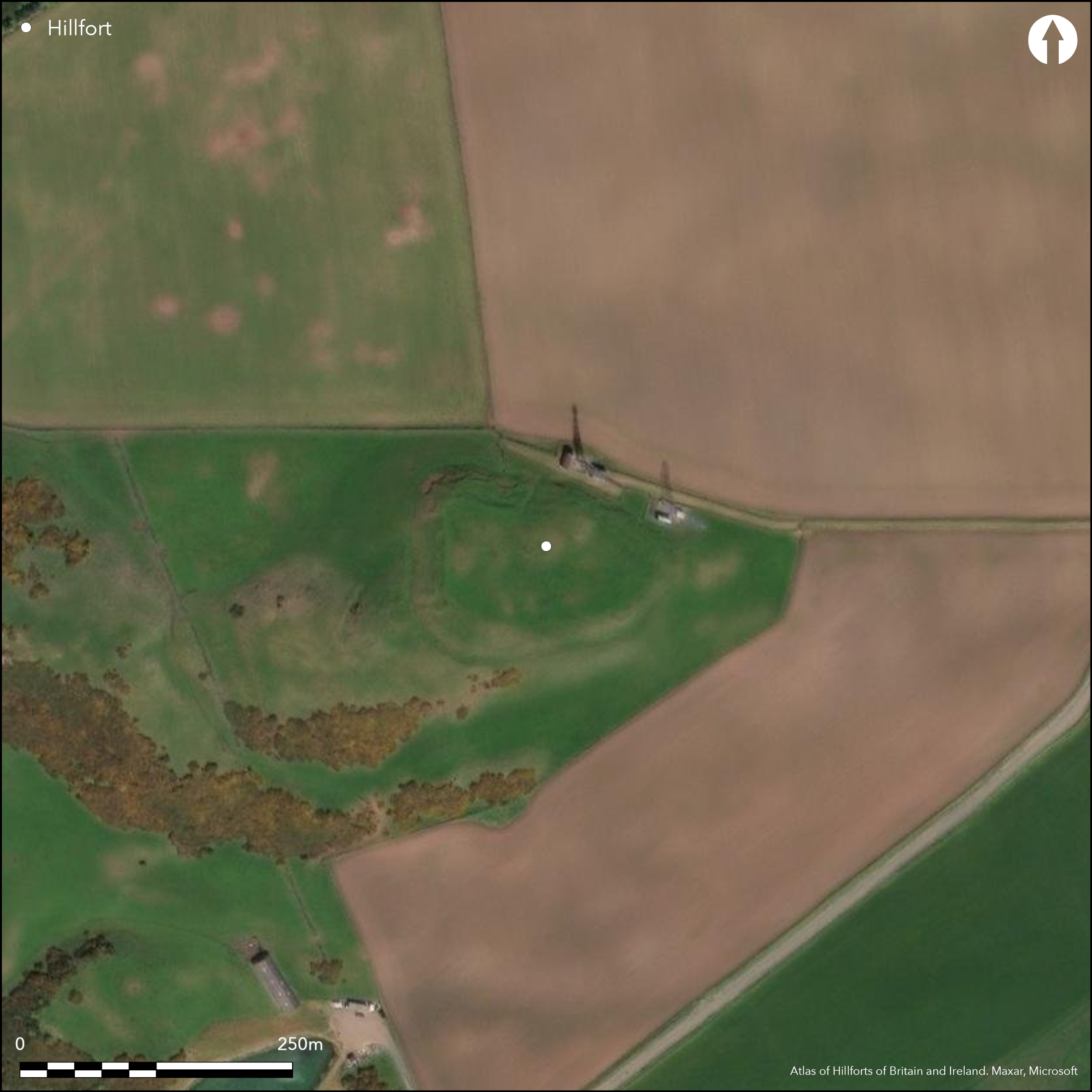
This fort is situated on the summit of Down Law. Pear-shaped on plan, it measures about 110m from E to W by 65m transversely (0.53ha) at the broader W end within a rampart that originally extended around the rim of the summit area but is barely visible around most of the circuit and heavily degraded by cultivation. Excavation in 1971 located the remains of the rampart on the N and traces of a low outer rampart at the foot of the slope below (Mountain 1971), which presumably extended the outer defences visible at the W end, where a ditch has been cut into the foot of the slope and flanked with a counterscarp bank. This is likely to have encircled the greater part of the fort, but more recent excavations and watching briefs have failed to identify any trace of outer defences adjacent to the telecommunications masts on the N side of the fort (Russell-White 1988; Strachan 1999). Another short length of ditch with a counterscarp bank loops round the foot of what was described in 1925 as a 'natural bastion' (RCAHMS 1933, 162, no.303, fig 302) in front of these defences at the W end, though its purpose is uncertain. The RCAHMS investigators believed it was protecting an entrance at this end, marked by a hollow extending up towards the summit area, but the ditch at the foot of the slope is unbroken, and the hollow may be the result of later activity, along with the large pit dug across its upper end. Other tracks have mounted the slope on the N and at the E tip, at the latter where the RCAHMS plan depicts what is either a small sector of the outer ditch and rampart or a quarry, but without excavation it is impossible to determine whether any of these is an entrance. Nothing is visible within the interior, which has been heavily cultivated, though in 1984 Edwina Proudfoot (1984) noted an internal palisade trench, presumably as a parchmark in the grass, immediately to the rear of the inner rampart.
Citizen Science: ✗
Reliability of Data: Confirmed
Reliability of Interpretation: Confirmed
X: -340782 Y: 7608818 (EPSG: 3857)
Longitude: -3.0612943490089464 Latitude: 56.2523563508856 (EPSG:4326)
Country: Scotland
Current County or Unitary Authority: Fife
Historic County: Fife
Current Parish/Community/Council/Townland: Kettle
None
| Extant | ✓ |
| Cropmark | ✗ |
| Likely Destroyed | ✗ |
None
| Woodland | ✗ |
| Commercial Forestry Plantation | ✗ |
| Parkland | ✗ |
| Pasture (Grazing) | ✓ |
| Arable | ✓ |
| Scrub/Bracken | ✗ |
| Bare Outcrop | ✗ |
| Heather/Moorland | ✗ |
| Heath | ✗ |
| Built-up | ✗ |
| Coastal Grassland | ✗ |
| Other | ✗ |
None
| Contour Fort | ✓ |
| Partial Contour Fort | ✗ |
| Promontory Fort | ✗ |
| Hillslope Fort | ✗ |
| Level Terrain Fort | ✗ |
| Marsh Fort | ✗ |
| Multiple Enclosure Fort | ✗ |
| Hilltop | ✓ |
| Coastal Promontory | ✗ |
| Inland Promontory | ✗ |
| Valley Bottom | ✗ |
| Knoll/Hillock/Outcrop | ✗ |
| Ridge | ✗ |
| Cliff/Plateau-edge/Scarp | ✗ |
| Hillslope | ✗ |
| Lowland | ✗ |
| Spur | ✗ |
Dominant Topographic Feature: None
| North | ✗ |
| Northeast | ✗ |
| East | ✗ |
| Southeast | ✗ |
| South | ✗ |
| Southwest | ✗ |
| West | ✗ |
| Northwest | ✗ |
| Level | ✓ |
Altitude: 240.0m
N/A
There are neither stratified artefacts nor radiocarbon dates to provide a chronology for the defences.
Reliability: D - None
| Pre 1200BC | ✗ |
| 1200BC - 800BC | ✗ |
| 800BC - 400BC | ✗ |
| 400BC - AD50 | ✗ |
| AD50 - AD400 | ✗ |
| AD400 - AD 800 | ✗ |
| Post AD800 | ✗ |
| Unknown | ✓ |
| Pre Hillfort: | None |
| Post Hillfort: | Ploughed down |
None
| 1st Identified Written Reference (1791): | Noted (Stat Acct, i, 1791, 381) |
| 1st Identified Map Depiction (1854): | Annotated Fort on the 1st edition OS 6-inch map (Fife 1856, sheet 17) |
| Other (1893): | OS 25-inch depiction (Fifeshire 1895, 20.3) |
| Earthwork Survey (1925): | Plan and description (RCAHMS 1933, 162, no.303, fig 302) |
| Other (1936): | Scheduled |
| Other (1951): | Viisted for RCAHMS Survey of Marginal Lands |
| Other (1962): | Revised at 1:2500 by the OS |
| Excavation (1971): | Evaluation trench (Mountain 1971) |
| Other (1984): | Palisade trench noted (Proudfoot 1984) |
| Excavation (1988): | Evaluation (Russell-White 1988) |
| Other (1999): | Watching brief (Strachan 1999) |
Cultivated relatively recently and featureless
None
| None | ✓ |
| Spring | ✗ |
| Stream | ✗ |
| Pool | ✗ |
| Flush | ✗ |
| Well | ✗ |
| Other | ✗ |
None
| No Known Features | ✓ |
| Round Stone Structures | ✗ |
| Rectangular Stone Structures | ✗ |
| Curvilinear Platforms | ✗ |
| Other Roundhouse Evidence | ✗ |
| Pits | ✗ |
| Quarry Hollows | ✗ |
| Other | ✗ |
None
| No Known Excavation | ✓ |
| Pits | ✗ |
| Postholes | ✗ |
| Roundhouses | ✗ |
| Rectangular Structures | ✗ |
| Roads/Tracks | ✗ |
| Quarry Hollows | ✗ |
| Other | ✗ |
| Nothing Found | ✗ |
None
| No Known Geophysics | ✓ |
| Pits | ✗ |
| Roundhouses | ✗ |
| Rectangular Structures | ✗ |
| Roads/Tracks | ✗ |
| Quarry Hollows | ✗ |
| Other | ✗ |
| Nothing Found | ✗ |
None
| No Known Finds | ✓ |
| Pottery | ✗ |
| Metal | ✗ |
| Metalworking | ✗ |
| Human Bones | ✗ |
| Animal Bones | ✗ |
| Lithics | ✗ |
| Environmental | ✗ |
| Other | ✗ |
NO APPARENT FEATURES
| APs Not Checked | ✗ |
| None | ✓ |
| Roundhouses | ✗ |
| Rectangular Structures | ✗ |
| Pits | ✗ |
| Postholes | ✗ |
| Roads/Tracks | ✗ |
| Other | ✗ |
See main summary
| 3: | Large sectors of the defences ploughed down |
| 2: | Uncertain whether any of the gaps are original entrances |
Guard Chambers: ✗
Chevaux de Frise: ✗
| 1. Barbican (West): | The function of the outer works as attributed by RCAHMS in 1925, but not wholly convincing |
| 2. Simple Gap (East): | The access used for agricultural operations at the E end, but with not clear evidence that it is original |
Single rampart round the summit with an outer ditch and counterscarp bank at the foot of the slope, and an out-lying ditch and rampart on the WSW
| Area 1: | 0.53ha. |
| Total: | 0.53ha. |
Total Footprint Area: 0.15ha.
None
| ✗ | None |
| ✓ | None |
| NE Quadrant: | 1 |
| SE Quadrant: | 1 |
| SW Quadrant: | 3 |
| NW Quadrant: | 2 |
| Total: | 3 |
| Partial Univallate | ✓ |
| Univallate | ✗ |
| Partial Bivallate | ✓ |
| Bivallate | ✗ |
| Partial Multivallate | ✓ |
| Multivallate | ✗ |
| Unknown | ✗ |
| Partial Univallate | ✗ |
| Univallate | ✗ |
| Partial Bivallate | ✗ |
| Bivallate | ✗ |
| Partial Multivallate | ✗ |
| Multivallate | ✗ |
None
| None | ✗ |
| Earthen Bank | ✓ |
| Stone Wall | ✗ |
| Rubble | ✗ |
| Wall-walk | ✗ |
| Evidence of Timber | ✗ |
| Vitrification | ✗ |
| Other Burning | ✗ |
| Palisade | ✗ |
| Counter Scarp Bank | ✗ |
| Berm | ✗ |
| Unfinished | ✗ |
| Other | ✗ |
None
| None | ✗ |
| Earthen Bank | ✗ |
| Stone Wall | ✓ |
| Murus Duplex | ✗ |
| Timber-framed | ✗ |
| Timber-laced | ✗ |
| Vitrification | ✗ |
| Other Burning | ✗ |
| Palisade | ✗ |
| Counter Scarp Bank | ✗ |
| Berm | ✗ |
| Unfinished | ✗ |
| No Known Excavation | ✗ |
| Other | ✗ |
| ✗ | None |
| ✓ | Additional ditch at W end forming an outer 'bastion' omitted |
Number of Ditches: 1
| ✗ | The outlying ditch around the 'natural bastion' at the W end (RCAHMS 1933, 162, no.303, fig 302), might be described as a small annexe, but in 1925 it was interpreted as an elaboration of the defences at the entrance, and while the entrance is not particularly convincing as an original feature on the most recent aerial photographs taken by RCAHMS, no subsequent visitor has challenged the existence of an entrance here. It makes no particular sense as an enclosure. |
Mountain, M J (1971) 'Fife, Down Law'. Disc Exc Scot (1971), 57
Proudfoot, E (1984) 'Down Law (Kettle p), fort'. Disc Exc Scot (1984), 8
RCAHMS. (1933) The Royal Commission on the Ancient and Historical Monuments and Constructions of Scotland. Eleventh report with inventory of monuments and constructions in the counties of Fife, Kinross, and Clackmannan. HMSO: Edinburgh
Russell-White, C J (1988) 'Downlaw (Kettle parish), hillfort'. Disc Exc Scot (1988), 12
Strachan, R. (1999) 'Down Law Fort (Kettle parish), watching brief'. Disc Exc Scot (1999), 47
Atlas of Hillforts:
Wikidata:
This work is licensed under CC BY-SA 4.0![]()
![]()
![]() and should be cited as:
and should be cited as:
Lock, Gary and Ralston, Ian. 2024. Atlas of Hillforts of Britain and Ireland. Available at: https://hillforts.arch.ox.ac.uk
Document Version 1.1