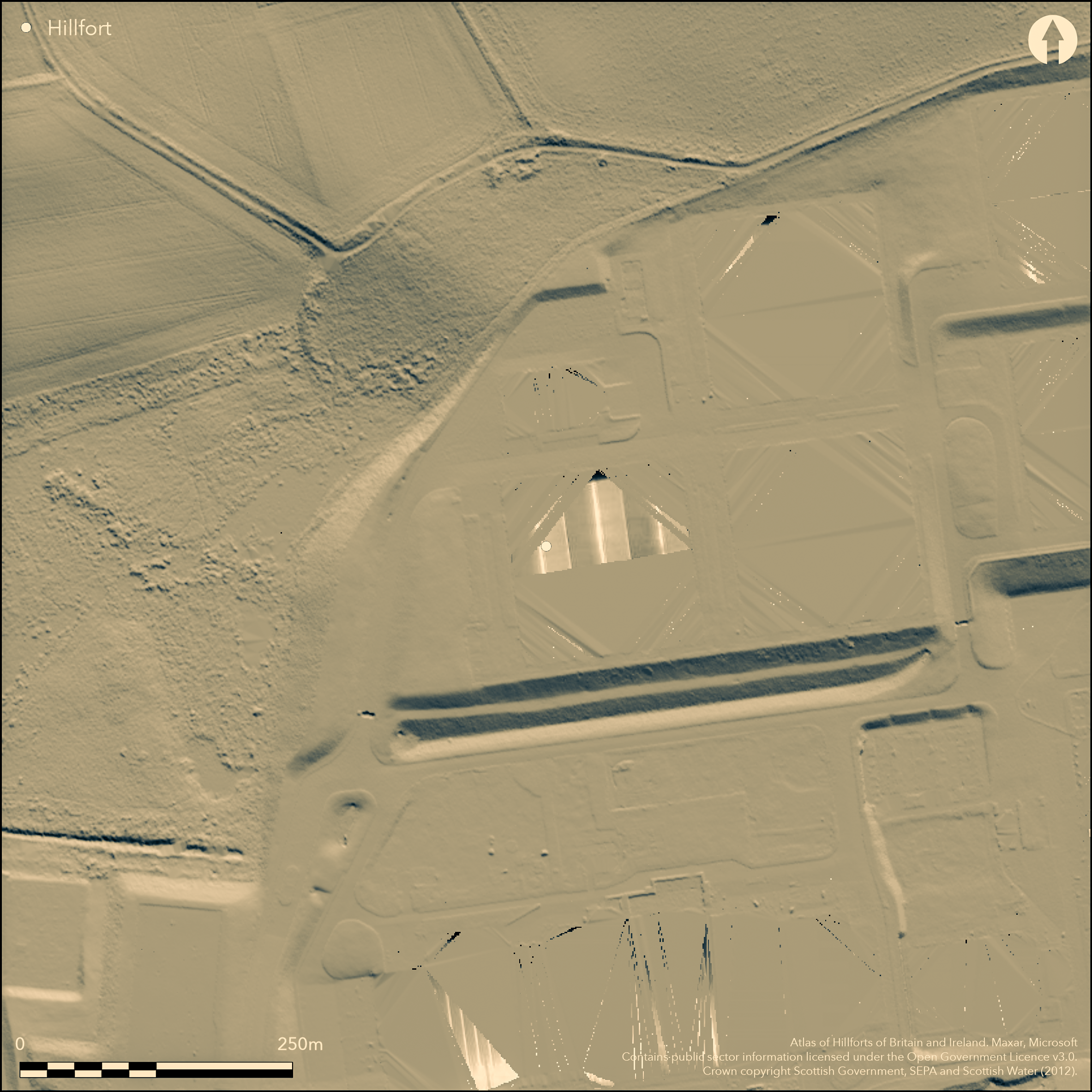
LiDAR 1m DTM Hillshade
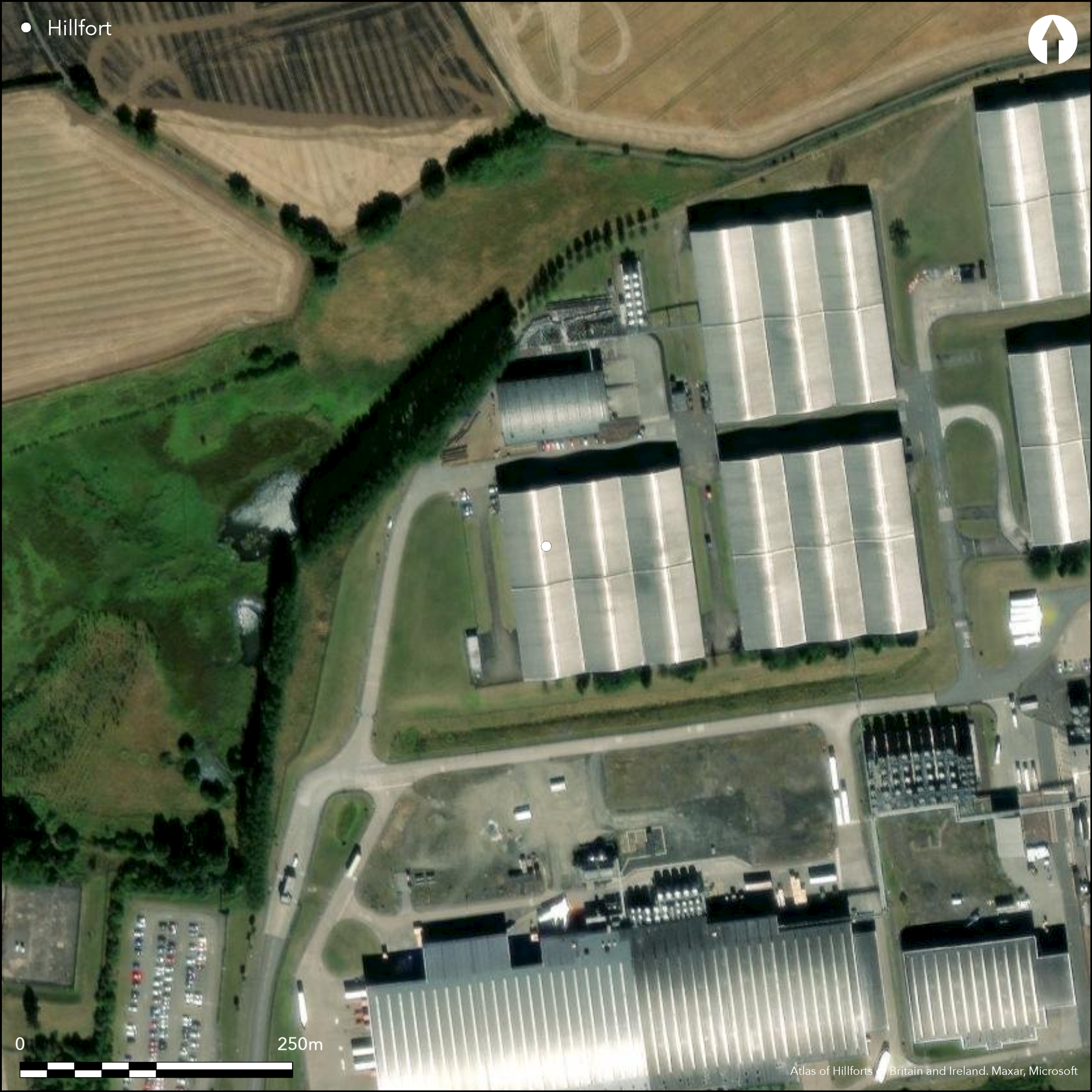
Satellite Imagery
LiDAR 1m DTM Hillshade
Satellite Imagery
Scroll left/right to view further images.
HER: Fife Council None (None)
NMR: NO 30 SE 17 (31330)
SM: None
NGR: NO 3590 0137
X: 335900 Y: 701379 (OSGB36)
First noted in 1951, by RCAHMS on vertical aerial photographs, more detailed oblique coverage was recorded by CUCAP in 1968, but by 1983 the greater part of the site lay beneath an industrial development, and more recent construction may have destroyed any trace of the outer ditches that lay outside the development on the W. Situated on a hillock forming the S end of a low spur otherwise surrounded by boggy low-lying ground, the CUCAP photographs reveal a complex enclosure with five concentric ditches set in a belt 35m deep. The irregular spacing of the ditches, however, and indeed their different breadths, indicate that they probably represented several separate periods of construction. The innermost was thus relatively narrow, and not much more than 1m in breadth, enclosing an area some 40m in diameter (0.12ha), while the second was 4m in breadth, forming an enclosure 50m in internal diameter (0.2ha). The third was also relatively narrow, varying from 1m to 2.5m, but the fourth was 4m in breadth, and the fifth and outermost around the foot of the hillock 6m, forming a particularly bold mark across the neck of the spur on the N. The only entrance is on the S and certainly pierces four of the ditches, but the innermost is less well defined here and may even continue across the gap.
Citizen Science: ✗
Reliability of Data: Confirmed
Reliability of Interpretation: Confirmed
X: -337824 Y: 7598479 (EPSG: 3857)
Longitude: -3.0347234162915724 Latitude: 56.200728386180714 (EPSG:4326)
Country: Scotland
Current County or Unitary Authority: Fife
Historic County: Fife
Current Parish/Community/Council/Townland: Scoonie
First recorded as a cropmark, this site falls within an industrial development, and while fragments of the outer ditches possibly survive on the W, to all intents and purposes it has been destroyed.
| Extant | ✗ |
| Cropmark | ✓ |
| Likely Destroyed | ✓ |
None
| Woodland | ✗ |
| Commercial Forestry Plantation | ✗ |
| Parkland | ✗ |
| Pasture (Grazing) | ✗ |
| Arable | ✗ |
| Scrub/Bracken | ✗ |
| Bare Outcrop | ✗ |
| Heather/Moorland | ✗ |
| Heath | ✗ |
| Built-up | ✓ |
| Coastal Grassland | ✗ |
| Other | ✗ |
None
| Contour Fort | ✓ |
| Partial Contour Fort | ✗ |
| Promontory Fort | ✗ |
| Hillslope Fort | ✗ |
| Level Terrain Fort | ✗ |
| Marsh Fort | ✗ |
| Multiple Enclosure Fort | ✗ |
| Hilltop | ✗ |
| Coastal Promontory | ✗ |
| Inland Promontory | ✗ |
| Valley Bottom | ✗ |
| Knoll/Hillock/Outcrop | ✓ |
| Ridge | ✗ |
| Cliff/Plateau-edge/Scarp | ✗ |
| Hillslope | ✗ |
| Lowland | ✗ |
| Spur | ✗ |
Dominant Topographic Feature: None
| North | ✗ |
| Northeast | ✗ |
| East | ✗ |
| Southeast | ✗ |
| South | ✗ |
| Southwest | ✗ |
| West | ✗ |
| Northwest | ✗ |
| Level | ✓ |
Altitude: 30.0m
N/A
In the absence of excavation, there are neither stratified artefacts nor radiocarbon dates to provide a chronology for the defences.
Reliability: D - None
| Pre 1200BC | ✗ |
| 1200BC - 800BC | ✗ |
| 800BC - 400BC | ✗ |
| 400BC - AD50 | ✗ |
| AD50 - AD400 | ✗ |
| AD400 - AD 800 | ✗ |
| Post AD800 | ✗ |
| Unknown | ✓ |
| Pre Hillfort: | None |
| Post Hillfort: | Ploughed flat and destroyed |
CUCAP took five photographs, one of which is held by RCAHMS
| 1st Identified Written Reference (1951): | First identified from vertical aerial photographs by RCAHMS for he Survey of Marginal Lands |
| Other (1952): | Visited by the OS |
| Other (1968): | Photographed by CUCAP |
| Other (1983): | Industrial development reported |
Featureless
None
| None | ✓ |
| Spring | ✗ |
| Stream | ✗ |
| Pool | ✗ |
| Flush | ✗ |
| Well | ✗ |
| Other | ✗ |
None
| No Known Features | ✓ |
| Round Stone Structures | ✗ |
| Rectangular Stone Structures | ✗ |
| Curvilinear Platforms | ✗ |
| Other Roundhouse Evidence | ✗ |
| Pits | ✗ |
| Quarry Hollows | ✗ |
| Other | ✗ |
None
| No Known Excavation | ✓ |
| Pits | ✗ |
| Postholes | ✗ |
| Roundhouses | ✗ |
| Rectangular Structures | ✗ |
| Roads/Tracks | ✗ |
| Quarry Hollows | ✗ |
| Other | ✗ |
| Nothing Found | ✗ |
None
| No Known Geophysics | ✓ |
| Pits | ✗ |
| Roundhouses | ✗ |
| Rectangular Structures | ✗ |
| Roads/Tracks | ✗ |
| Quarry Hollows | ✗ |
| Other | ✗ |
| Nothing Found | ✗ |
None
| No Known Finds | ✓ |
| Pottery | ✗ |
| Metal | ✗ |
| Metalworking | ✗ |
| Human Bones | ✗ |
| Animal Bones | ✗ |
| Lithics | ✗ |
| Environmental | ✗ |
| Other | ✗ |
NO APPARENT FEATURES
| APs Not Checked | ✗ |
| None | ✓ |
| Roundhouses | ✗ |
| Rectangular Structures | ✗ |
| Pits | ✗ |
| Postholes | ✗ |
| Roads/Tracks | ✗ |
| Other | ✗ |
See main summary
| 1: | Ploughed flat long before its destruction |
| 2: | None |
Guard Chambers: ✗
Chevaux de Frise: ✗
| 1. Simple Gap (South): | Piercing at least four of the ditches, though possibly not the innermost |
Up to five concentric ditches of variable breadth and spacing, presumably with upcast ramparts and probably representing several periods of enclosure
| Area 1: | 0.1ha. |
| Area 2: | 0.2ha. |
| Total: | 0.2ha. |
Total Footprint Area: 1.13ha.
None
| ✗ | None |
| ✓ | None |
| NE Quadrant: | 5 |
| SE Quadrant: | 5 |
| SW Quadrant: | 5 |
| NW Quadrant: | 5 |
| Total: | 5 |
| Partial Univallate | ✗ |
| Univallate | ✗ |
| Partial Bivallate | ✗ |
| Bivallate | ✗ |
| Partial Multivallate | ✗ |
| Multivallate | ✓ |
| Unknown | ✗ |
| Partial Univallate | ✗ |
| Univallate | ✗ |
| Partial Bivallate | ✗ |
| Bivallate | ✗ |
| Partial Multivallate | ✗ |
| Multivallate | ✗ |
None
| None | ✓ |
| Earthen Bank | ✗ |
| Stone Wall | ✗ |
| Rubble | ✗ |
| Wall-walk | ✗ |
| Evidence of Timber | ✗ |
| Vitrification | ✗ |
| Other Burning | ✗ |
| Palisade | ✗ |
| Counter Scarp Bank | ✗ |
| Berm | ✗ |
| Unfinished | ✗ |
| Other | ✗ |
None
| None | ✗ |
| Earthen Bank | ✗ |
| Stone Wall | ✗ |
| Murus Duplex | ✗ |
| Timber-framed | ✗ |
| Timber-laced | ✗ |
| Vitrification | ✗ |
| Other Burning | ✗ |
| Palisade | ✗ |
| Counter Scarp Bank | ✗ |
| Berm | ✗ |
| Unfinished | ✗ |
| No Known Excavation | ✓ |
| Other | ✗ |
| ✗ | None |
| ✓ | None |
Number of Ditches: 5
| ✗ | None |
No related records
Atlas of Hillforts:
Wikidata:
This work is licensed under CC BY-SA 4.0![]()
![]()
![]() and should be cited as:
and should be cited as:
Lock, Gary and Ralston, Ian. 2024. Atlas of Hillforts of Britain and Ireland. Available at: https://hillforts.arch.ox.ac.uk
Document Version 1.1