LiDAR 1m DTM Hillshade
Satellite Imagery
LiDAR 1m DTM Hillshade
Satellite Imagery
Scroll left/right to view further images.
HER: Fife Council None (None)
NMR: NO 32 SW 3 (31823)
SM: 2446
NGR: NO 3229 2154
X: 332290 Y: 721540 (OSGB36)
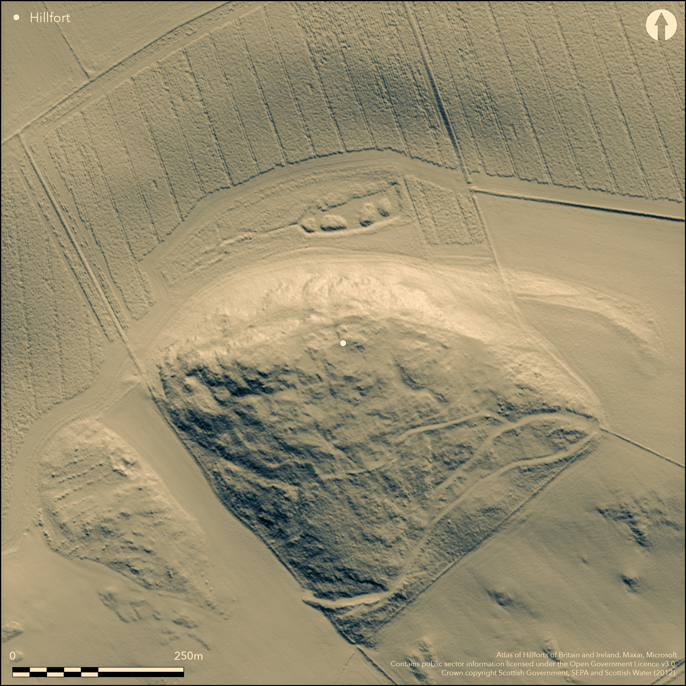
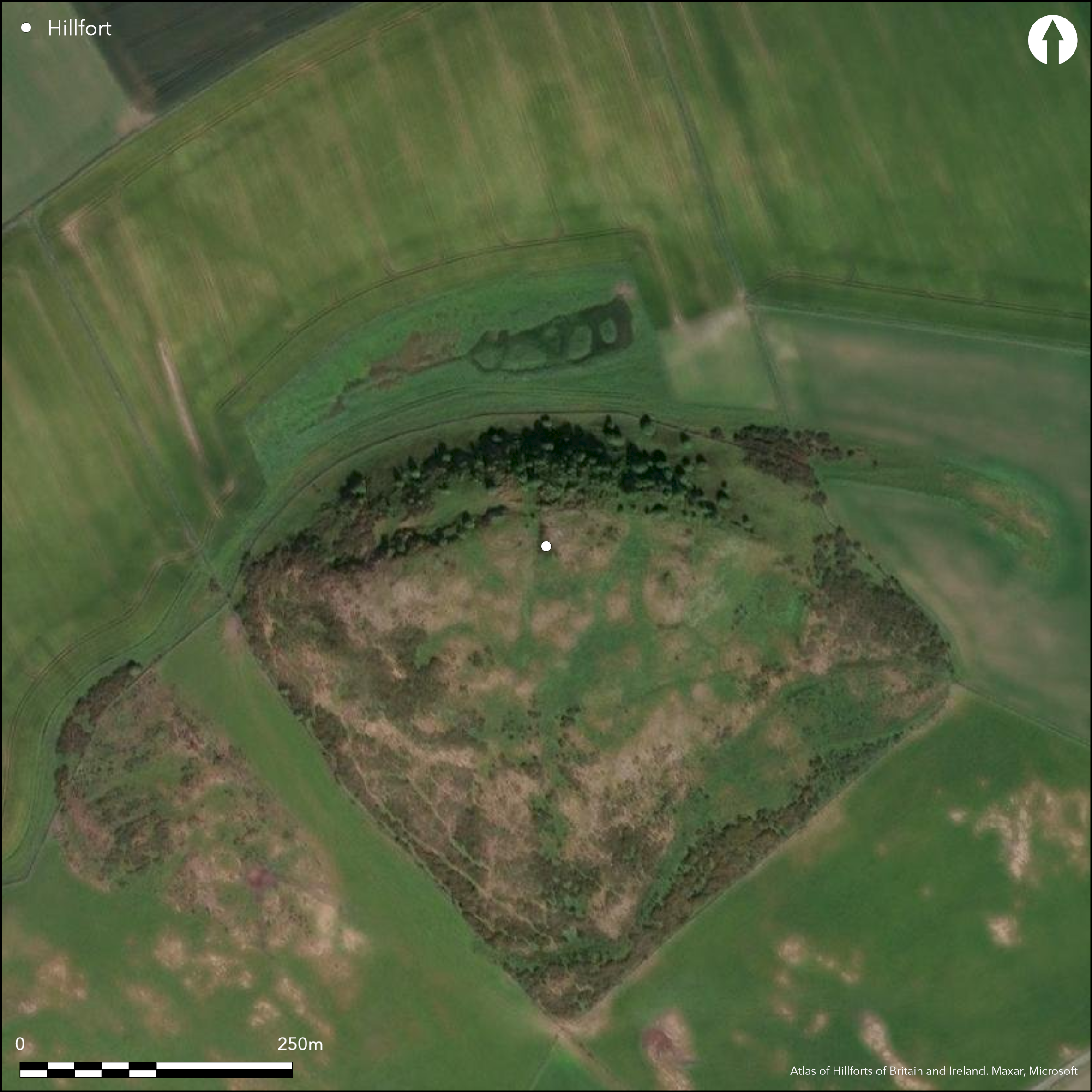
A large fort encloses the upper slopes of Green Craig, but both its ramparts have been heavily reduced by later stone robbing. Irregular on plan, it measures internally about 180m from E to W by 70m transversely (1.1ha). Where best preserved, the inner rampart is reduced to little more than a stony scarp following the leading edges of natural terraces and rock outcrops round the margins of the hill, and though on the NW it seems to turn back along the crest of the steep and rocky escarpment forming the N flank of the hill, there is no trace of it on the NE. The course of the outer rampart is even more sinuous, ranging between 30m and 15m down the slope, and first appearing on the edge of a hollow trackway at what may be an original entrance on the lip of the escarpment on the NW. At one point on the S a few facing stones are visible, suggesting an original thickness of about 2.7m, but it then peters out in a broad gap and there is a short segment of a second rampart set immediately to its rear. This curious feature is conceivably a complex entrance, the insertion of the rampart to the rear creating entrances between overlapping terminals to either side, but such a feature is otherwise unknown in the design of Scottish hillfort entrances, and it is perhaps more likely that this represents evidence of multiperiod construction in which the inner line was superseded by the outer. Nevertheless, a hollow trackway mounts the slope from the W end of the inner segment, making for a gap in the inner rampart and indicating that there was originally an entrance at this point. Other entrances almost certainly existed at the E end of the fort, but it is difficult to distinguish original gaps from what may be more recent breaks. On the SE, for example, the outer rampart is crossed obliquely by a terraced trackway, before petering out adjacent to a second trackway terrace which bifurcates to cross the line of the inner rampart at two places. Perhaps more likely to be original is the trackway climbing into the interior from a gap between the inner rampart and the steep escarpment on the NE. While it is generally assumed that the inner and outer ramparts are part of a single scheme, a small oval enclosure on the summit, which measures 30m from NW to SE by 25m transversely within a wall probably about 1.8m in thickness, is thought to be a later homestead, though at a later date it seems to have been subdivided and a rectilinear hut built against its S side. The platforms for round-houses that are visible within the fort, however are not necessarily contemporary with the defences. Two of the eight identified by RCAHMS investigators in 1952 overlie the defences, one on the line of the inner rampart on the NW and the other the outer on the SE; one of the others lies between the two ramparts on the SE. Another lies adjacent to the small rectilinear homestead excavated in 1947 by Gerhard Bersu (1948) immediately below the defences on the E. The only other feature that has been noted within the interior is a waterlogged hollow on the NE side of the homestead on the summit, which the RCAHMS investigators speculated might be a well or cistern.
Citizen Science: ✗
Reliability of Data: Confirmed
Reliability of Interpretation: Confirmed
X: -344876 Y: 7634705 (EPSG: 3857)
Longitude: -3.0980769310241865 Latitude: 56.381330118815534 (EPSG:4326)
Country: Scotland
Current County or Unitary Authority: Fife
Historic County: Fife
Current Parish/Community/Council/Townland: Creich
None
| Extant | ✓ |
| Cropmark | ✗ |
| Likely Destroyed | ✗ |
None
| Woodland | ✗ |
| Commercial Forestry Plantation | ✗ |
| Parkland | ✗ |
| Pasture (Grazing) | ✓ |
| Arable | ✗ |
| Scrub/Bracken | ✗ |
| Bare Outcrop | ✗ |
| Heather/Moorland | ✓ |
| Heath | ✗ |
| Built-up | ✗ |
| Coastal Grassland | ✗ |
| Other | ✗ |
None
| Contour Fort | ✓ |
| Partial Contour Fort | ✗ |
| Promontory Fort | ✗ |
| Hillslope Fort | ✗ |
| Level Terrain Fort | ✗ |
| Marsh Fort | ✗ |
| Multiple Enclosure Fort | ✗ |
| Hilltop | ✓ |
| Coastal Promontory | ✗ |
| Inland Promontory | ✗ |
| Valley Bottom | ✗ |
| Knoll/Hillock/Outcrop | ✗ |
| Ridge | ✗ |
| Cliff/Plateau-edge/Scarp | ✗ |
| Hillslope | ✗ |
| Lowland | ✗ |
| Spur | ✗ |
Dominant Topographic Feature: None
| North | ✗ |
| Northeast | ✗ |
| East | ✗ |
| Southeast | ✗ |
| South | ✗ |
| Southwest | ✗ |
| West | ✗ |
| Northwest | ✗ |
| Level | ✓ |
Altitude: 189.0m
N/A
In the absence of excavation, there are neither stratified artefacts nor radiocarbon dates to provide a chronology for the defences.
Reliability: D - None
| Pre 1200BC | ✗ |
| 1200BC - 800BC | ✗ |
| 800BC - 400BC | ✗ |
| 400BC - AD50 | ✗ |
| AD50 - AD400 | ✗ |
| AD400 - AD 800 | ✗ |
| Post AD800 | ✗ |
| Unknown | ✓ |
| Pre Hillfort: | None |
| Post Hillfort: | None |
Photographed by RCAHMS Aerial Survey Programme in 1989
| 1st Identified Map Depiction (1854): | Annotated Fort on the 1st edition OS 6-inch map (Fife 1855, sheet 5) |
| Other (1893): | Depiction on OS 25-inch map (Fifeshire 1894, sheet 3.14) |
| Other (1925): | Description (RCAHMS 1933, 68, no.144) |
| Other (1947): | Description by Gerhard Bersu generated when excavating on the rectilinear homestead at the E end (1948, 264-6) |
| Earthwork Survey (1952): | Plan and description for RCAHMS Survey of Marginal Lands (RCAHMS FID 10/1-3 & DP158222-4; Feachem 1963, 125) |
| Other (1956): | Visited by the OS |
| Other (1964): | Scheduled |
| Other (1970): | Resurveyed at 1:2500 by the OS |
| Other (1992): | Re-Scheduled |
Eight house platforms identified, but two overlie the defences, one lies between the two ramparts, and another adjacent to a rectilinear homestead outside the defences on the E
RCAHMS speculated that a waterlogged hollow within the homestead on the summit was a well.
| None | ✗ |
| Spring | ✗ |
| Stream | ✗ |
| Pool | ✗ |
| Flush | ✗ |
| Well | ✗ |
| Other | ✓ |
None
| No Known Features | ✗ |
| Round Stone Structures | ✗ |
| Rectangular Stone Structures | ✗ |
| Curvilinear Platforms | ✓ |
| Other Roundhouse Evidence | ✗ |
| Pits | ✗ |
| Quarry Hollows | ✗ |
| Other | ✗ |
None
| No Known Excavation | ✓ |
| Pits | ✗ |
| Postholes | ✗ |
| Roundhouses | ✗ |
| Rectangular Structures | ✗ |
| Roads/Tracks | ✗ |
| Quarry Hollows | ✗ |
| Other | ✗ |
| Nothing Found | ✗ |
None
| No Known Geophysics | ✓ |
| Pits | ✗ |
| Roundhouses | ✗ |
| Rectangular Structures | ✗ |
| Roads/Tracks | ✗ |
| Quarry Hollows | ✗ |
| Other | ✗ |
| Nothing Found | ✗ |
Perforated stone disc donated to the NMAS in 1925
| No Known Finds | ✗ |
| Pottery | ✗ |
| Metal | ✗ |
| Metalworking | ✗ |
| Human Bones | ✗ |
| Animal Bones | ✗ |
| Lithics | ✗ |
| Environmental | ✗ |
| Other | ✓ |
NO APPARENT FEATURES
| APs Not Checked | ✓ |
| None | ✗ |
| Roundhouses | ✗ |
| Rectangular Structures | ✗ |
| Pits | ✗ |
| Postholes | ✗ |
| Roads/Tracks | ✗ |
| Other | ✗ |
See main summary
| 7: | None |
| 2: | Unclear which of these entrances is original, and whether the hollow ways relate to contemporary traffic |
Guard Chambers: ✗
Chevaux de Frise: ✗
| 1. Simple Gap (East): | through inner rampart, hollow trackway up slope |
| 2. Hollow Way (South east): | NE spur of a bifurcating trackway crosses the inner rampart at right-angles |
| 3. Hollow Way (South east): | W spur of a bifurcating trackway crosses the inner rampart obliquely |
| 4. Hollow Way (South): | Plan unclear at the outer rampart |
| 5. Hollow Way (South): | Trackway from 4 passes obliquely through the inner rampart to expose the visitor's right side |
| 6. Simple Gap (West): | Approached circuitously by trackway leading up form 7 |
| 7. Hollow Way (North west): | Passes through the outer rampart, heading for the inner at 6 |
Two walls or ramparts, the inner of which may originally have formed a complete circuit
| Area 1: | 1.1ha. |
| Total: | 1.1ha. |
Total Footprint Area: 1.8ha.
None
| ✗ | None |
| ✗ | None |
| NE Quadrant: | 0 |
| SE Quadrant: | 2 |
| SW Quadrant: | 2 |
| NW Quadrant: | 1 |
| Total: | 2 |
| Partial Univallate | ✓ |
| Univallate | ✗ |
| Partial Bivallate | ✓ |
| Bivallate | ✗ |
| Partial Multivallate | ✗ |
| Multivallate | ✗ |
| Unknown | ✗ |
| Partial Univallate | ✗ |
| Univallate | ✗ |
| Partial Bivallate | ✗ |
| Bivallate | ✗ |
| Partial Multivallate | ✗ |
| Multivallate | ✗ |
None
| None | ✗ |
| Earthen Bank | ✗ |
| Stone Wall | ✓ |
| Rubble | ✓ |
| Wall-walk | ✗ |
| Evidence of Timber | ✗ |
| Vitrification | ✗ |
| Other Burning | ✗ |
| Palisade | ✗ |
| Counter Scarp Bank | ✗ |
| Berm | ✗ |
| Unfinished | ✗ |
| Other | ✗ |
None
| None | ✗ |
| Earthen Bank | ✗ |
| Stone Wall | ✗ |
| Murus Duplex | ✗ |
| Timber-framed | ✗ |
| Timber-laced | ✗ |
| Vitrification | ✗ |
| Other Burning | ✗ |
| Palisade | ✗ |
| Counter Scarp Bank | ✗ |
| Berm | ✗ |
| Unfinished | ✗ |
| No Known Excavation | ✓ |
| Other | ✗ |
| ✗ | None |
| ✗ | None |
Number of Ditches: None
| ✗ | None |
Feachem, R W 1963 Guide to Prehistoric Scotland. Batsford: London
RCAHMS (1933) The Royal Commission on the Ancient and Historical Monuments and Constructions of Scotland. Eleventh report with inventory of monuments and constructions in the counties of Fife, Kinross, and Clackmannan. HMSO: Edinburgh
Atlas of Hillforts:
Wikidata:
This work is licensed under CC BY-SA 4.0![]()
![]()
![]() and should be cited as:
and should be cited as:
Lock, Gary and Ralston, Ian. 2024. Atlas of Hillforts of Britain and Ireland. Available at: https://hillforts.arch.ox.ac.uk
Document Version 1.1