LiDAR 1m DTM Hillshade
Satellite Imagery
LiDAR 1m DTM Hillshade
Satellite Imagery
Scroll left/right to view further images.
HER: Fife Council None (None)
NMR: NO 32 SW 22 (31814)
SM: 814
NGR: NO 3053 2019
X: 330530 Y: 720190 (OSGB36)
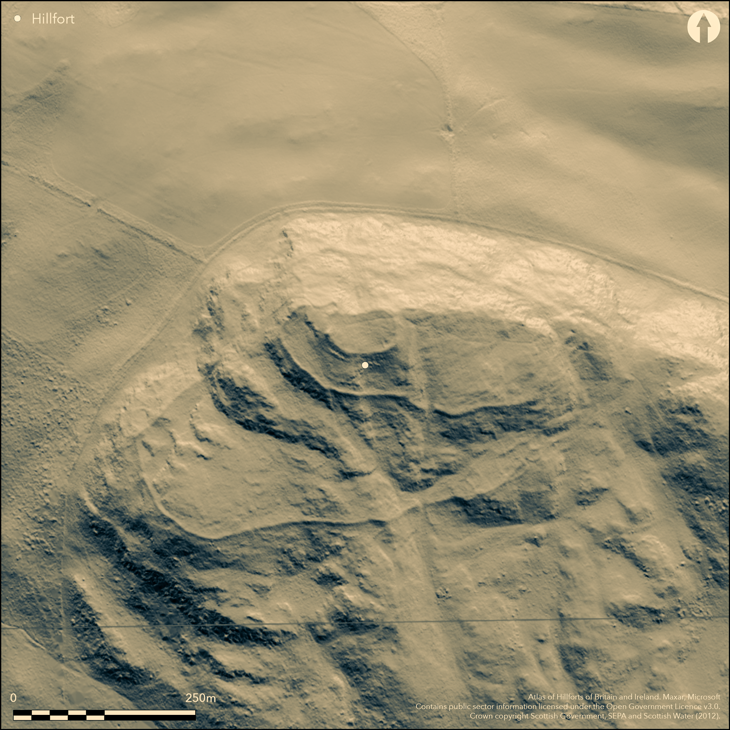
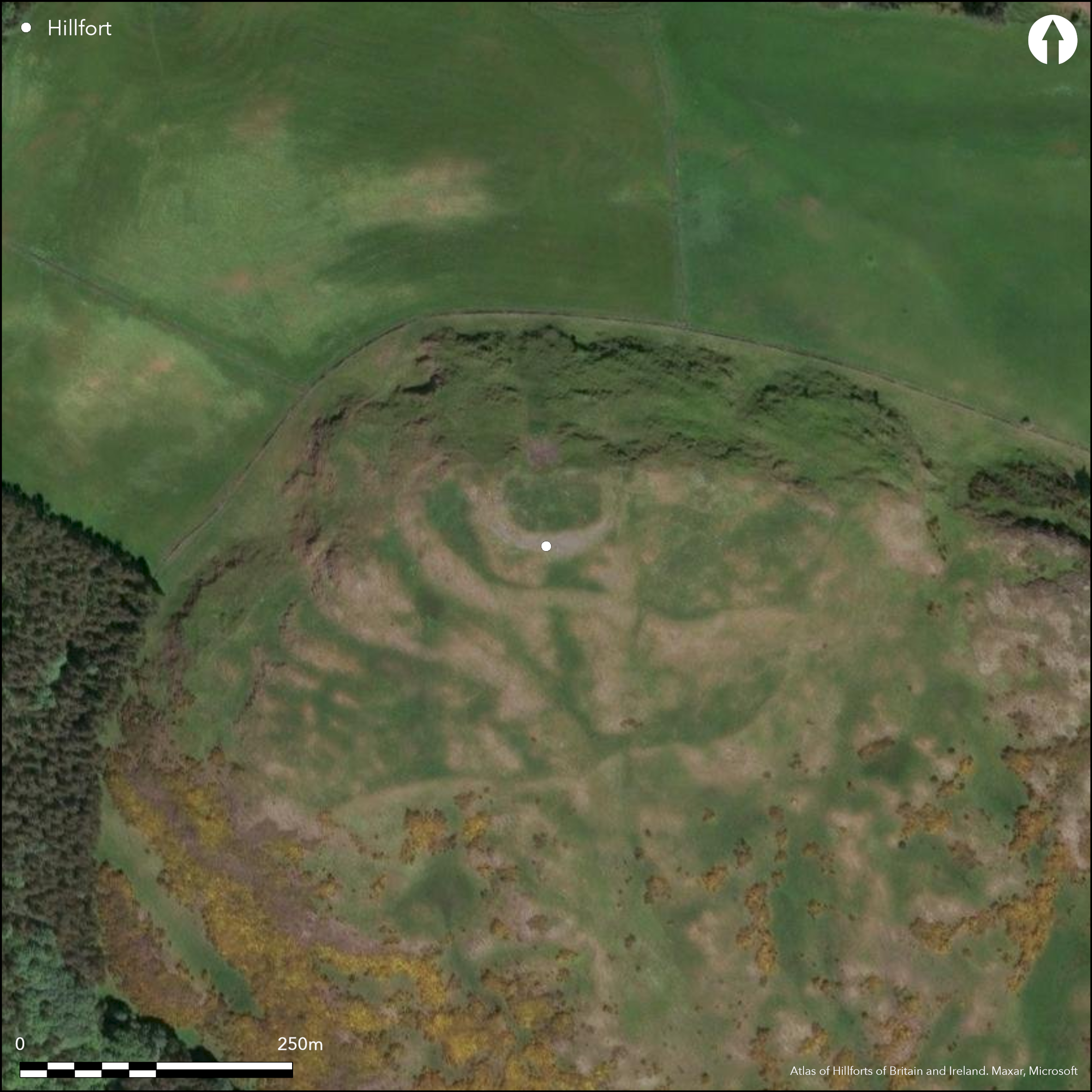
A complex fort occupies the upper slopes and summit of Norman's Law, commanding spectacular views N and W across the Firth of Tay. It comprises no fewer than four separate enclosures, the innermost being an oval enclosure on the summit measuring some 53m from E to W by 29m transversely (0.13ha) within a wall about 3.6m in thickness; a single hut-circle lies adjacent to an area of paving within the E end of the interior and a stone-filled hollow at the rear of the wall on the SE was probably a well (Small 1823, 231). The entrance is on the ENE. At the time that RCAHMS investigators drew up a plan in 1954 for the Survey of Marginal Lands, they were unable to determine the precise relationship between this inner work and the enclosure that surrounds it, suggesting that the wall of the outer, which on the NW turns inwards to meet the inner at right-angles, either abutted it or was bonded into it. Richard Feachem asserted subsequently that the inner enclosure almost certainly overlay the outer wall (1963, 125), though this assertion is probably based on his model of early medieval citadel forts rather than an observation of the field evidence here on Norman's Law. This second enclosure, termed the Western Enclosure in the RCAHMS description of 1954, measures about 100m from E to W by 65m transversely (0.52ha) and is bounded by a wall about 3.5m in thickness, but this, on plan at least, appears to be a subdivision of a larger enclosure taking in the whole of the summit area, and measuring internally a maximum of 215m from E to W by 75m transversely (1.22ha). The entrance into this larger enclosure is midway along the S side and gave access into the E half of the interior, which in the RCAHMS description of 1954 is termed the Eastern Enclosure and was regarded as an annexe to the Western Enclosure, largely because the E half occupies a lower less defensible terrace. They supported this interpretation with the observation that the only entrance into the Western Enclosure was from the E half at the N end of the common wall that separated them. In truth the relationship of the common wall that separates the two halves of this larger enclosure to the wall forming its S side is unknown, and the configuration of these defences may be reconstructed in several different ways; though again Feachem believed they included the remains of a single large fort. Likewise the relationship to the outermost defences to these inner enclosures is not known, its wall following natural terraces around the flanks of the hill to enclose an area measuring 350m from ENE to WSW by 190m transversely (5ha). A well-formed entrance is visible on the S, from which an engineered trackway mounts the slope to the entrance into the large summit enclosure. To the E of the entrance there are a series of enclosures and hut-circles overlying the ruins of the wall, apparently representing a later unenclosed settlement; the status of the rest of the ten hut-circles lying within the interior, and another five in the Eastern Enclosure, is less certain; several small rectangular footings are also visible immediately within the outer entrance and the Eastern Enclosure.
Citizen Science: ✗
Reliability of Data: Confirmed
Reliability of Interpretation: Confirmed
X: -348009 Y: 7632216 (EPSG: 3857)
Longitude: -3.1262143719851476 Latitude: 56.368948022973434 (EPSG:4326)
Country: Scotland
Current County or Unitary Authority: Fife
Historic County: Fife
Current Parish/Community/Council/Townland: Dunbog
None
| Extant | ✓ |
| Cropmark | ✗ |
| Likely Destroyed | ✗ |
None
| Woodland | ✗ |
| Commercial Forestry Plantation | ✗ |
| Parkland | ✗ |
| Pasture (Grazing) | ✓ |
| Arable | ✗ |
| Scrub/Bracken | ✗ |
| Bare Outcrop | ✗ |
| Heather/Moorland | ✓ |
| Heath | ✗ |
| Built-up | ✗ |
| Coastal Grassland | ✗ |
| Other | ✗ |
None
| Contour Fort | ✓ |
| Partial Contour Fort | ✗ |
| Promontory Fort | ✗ |
| Hillslope Fort | ✗ |
| Level Terrain Fort | ✗ |
| Marsh Fort | ✗ |
| Multiple Enclosure Fort | ✓ |
| Hilltop | ✓ |
| Coastal Promontory | ✗ |
| Inland Promontory | ✗ |
| Valley Bottom | ✗ |
| Knoll/Hillock/Outcrop | ✗ |
| Ridge | ✗ |
| Cliff/Plateau-edge/Scarp | ✗ |
| Hillslope | ✗ |
| Lowland | ✗ |
| Spur | ✗ |
Dominant Topographic Feature: None
| North | ✗ |
| Northeast | ✗ |
| East | ✗ |
| Southeast | ✗ |
| South | ✗ |
| Southwest | ✗ |
| West | ✗ |
| Northwest | ✗ |
| Level | ✓ |
Altitude: 285.0m
N/A
In the absence of excavation, there are neither stratified artefacts nor radiocarbon dates to provide a chronology for the defences.
Reliability: D - None
| Pre 1200BC | ✗ |
| 1200BC - 800BC | ✗ |
| 800BC - 400BC | ✗ |
| 400BC - AD50 | ✗ |
| AD50 - AD400 | ✗ |
| AD400 - AD 800 | ✗ |
| Post AD800 | ✗ |
| Unknown | ✓ |
| Pre Hillfort: | None |
| Post Hillfort: | Overlying unenclosed settlement |
None
| 1st Identified Written Reference (1823): | Description by Andrew Small (1823, 231) |
| 1st Identified Map Depiction (1854): | Annotated Fort on the 1st edition OS 6-inch map (Fife 1855, sheet 5) |
| Other (1893): | OS 25-inch depiction (Fifeshire 1895, sheet 7.1) |
| Earthwork Survey (1926): | Plan and description (RCAHMS 1933, 104-5, no.193, fig 222; RCAHMS FID 15/1-2 & DP158232) |
| Other (1936): | Scheduled |
| Earthwork Survey (1954): | Plan and description for RCAHMS Survey of Marginal Lands (RCAHMS FID 15/3-5 & DP 158234-6; Feachem 1963, 125; 1966, 82-4) |
| Other (1956): | Visited by the OS |
| Other (1970): | Surveyed at 1:2500 by the OS |
Thirteen hut-circles and at least four rectangular footings, and another three hut-circles built against the exterior of the outermost rampart on the SE
A well in the innermost enclosure has been filled in (Small 1823, 231)
| None | ✗ |
| Spring | ✗ |
| Stream | ✗ |
| Pool | ✗ |
| Flush | ✗ |
| Well | ✓ |
| Other | ✗ |
None
| No Known Features | ✗ |
| Round Stone Structures | ✓ |
| Rectangular Stone Structures | ✓ |
| Curvilinear Platforms | ✗ |
| Other Roundhouse Evidence | ✗ |
| Pits | ✗ |
| Quarry Hollows | ✗ |
| Other | ✗ |
None
| No Known Excavation | ✓ |
| Pits | ✗ |
| Postholes | ✗ |
| Roundhouses | ✗ |
| Rectangular Structures | ✗ |
| Roads/Tracks | ✗ |
| Quarry Hollows | ✗ |
| Other | ✗ |
| Nothing Found | ✗ |
None
| No Known Geophysics | ✓ |
| Pits | ✗ |
| Roundhouses | ✗ |
| Rectangular Structures | ✗ |
| Roads/Tracks | ✗ |
| Quarry Hollows | ✗ |
| Other | ✗ |
| Nothing Found | ✗ |
Fragment of shale bracelet found in RCAHMS survey in 1954 (Proc Soc Antiq Scot 88, [1954-6], 230)
| No Known Finds | ✗ |
| Pottery | ✗ |
| Metal | ✗ |
| Metalworking | ✗ |
| Human Bones | ✗ |
| Animal Bones | ✗ |
| Lithics | ✗ |
| Environmental | ✗ |
| Other | ✓ |
Traces of several of the hut-circles
| APs Not Checked | ✗ |
| None | ✗ |
| Roundhouses | ✓ |
| Rectangular Structures | ✗ |
| Pits | ✗ |
| Postholes | ✗ |
| Roads/Tracks | ✗ |
| Other | ✗ |
See main summary
| 4: | None |
| 2: | Four separate entrances identifiable, each probably in a separate phase of enclosure |
Guard Chambers: ✗
Chevaux de Frise: ✗
| 1. Simple Gap (North east): | In innermost enclosure |
| 2. Simple Gap (North east): | In Western Enclosure, in the wall separating it from the Eastern Enclosure |
| 3. Simple Gap (South): | In large hilltop enclosure, entering the Eastern Enclosure, and approached by an engineered track |
| 4. Simple Gap (South): | Into the large outermost enclosure |
Probably a multiperiod series of univallate enclosures around the summit of the hill
| Area 1: | 0.13ha. |
| Area 2: | 0.52ha. |
| Area 3: | 1.22ha. |
| Area 4: | 5ha. |
| Total: | 5.0ha. |
Total Footprint Area: 5.0ha.
None
| ✓ | But not clear what the sequence may be |
| ✗ | None |
| NE Quadrant: | 3 |
| SE Quadrant: | 4 |
| SW Quadrant: | 3 |
| NW Quadrant: | 3 |
| Total: | 4 |
| Partial Univallate | ✗ |
| Univallate | ✗ |
| Partial Bivallate | ✗ |
| Bivallate | ✗ |
| Partial Multivallate | ✗ |
| Multivallate | ✓ |
| Unknown | ✗ |
| Partial Univallate | ✗ |
| Univallate | ✓ |
| Partial Bivallate | ✗ |
| Bivallate | ✗ |
| Partial Multivallate | ✗ |
| Multivallate | ✗ |
None
| None | ✗ |
| Earthen Bank | ✗ |
| Stone Wall | ✓ |
| Rubble | ✗ |
| Wall-walk | ✗ |
| Evidence of Timber | ✗ |
| Vitrification | ✗ |
| Other Burning | ✗ |
| Palisade | ✗ |
| Counter Scarp Bank | ✗ |
| Berm | ✗ |
| Unfinished | ✗ |
| Other | ✗ |
None
| None | ✗ |
| Earthen Bank | ✗ |
| Stone Wall | ✗ |
| Murus Duplex | ✗ |
| Timber-framed | ✗ |
| Timber-laced | ✗ |
| Vitrification | ✗ |
| Other Burning | ✗ |
| Palisade | ✗ |
| Counter Scarp Bank | ✗ |
| Berm | ✗ |
| Unfinished | ✗ |
| No Known Excavation | ✓ |
| Other | ✗ |
| ✗ | None |
| ✗ | None |
Number of Ditches: None
| ✓ | While the field evidence suggests that the separate lines of ramparts represent the remains of a series of successive enclosures of different sizes, they might also be interpreted as a citadel enclosure with a series of large annexes. |
Feachem, R W 1963 Guide to Prehistoric Scotland. Batsford: London
Feachem, R W (1966) The hill-forts of northern Britain'. 59-87 in Rivet, A L F (ed) The iron age in northern Britain. Edinburgh
RCAHMS (1933) The Royal Commission on the Ancient and Historical Monuments and Constructions of Scotland. Eleventh report with inventory of monuments and constructions in the counties of Fife, Kinross, and Clackmannan. HMSO: Edinburgh
Small, A (1823) Interesting Roman Antiquities recently discovered in Fife, ascertaining the site of the great battle fought betwixt Agricola and GalGacus; with the discovery of the position of five Roman towns, and of the site and names of upwards of seventy Roman forts: also Observations regarding the Ancient Palaces of the Pictish Kings in the Town of Abernethy, and other local antiquities. Edinburgh
Atlas of Hillforts:
Wikidata:
This work is licensed under CC BY-SA 4.0![]()
![]()
![]() and should be cited as:
and should be cited as:
Lock, Gary and Ralston, Ian. 2024. Atlas of Hillforts of Britain and Ireland. Available at: https://hillforts.arch.ox.ac.uk
Document Version 1.1