Satellite Imagery
Satellite Imagery
HER: Perth and Kinross Heritage Trust MPK5646 (None)
NMR: NT 09 NE 1 (49618)
SM: None
NGR: NT 0887 9682
X: 308873 Y: 696821 (OSGB36)
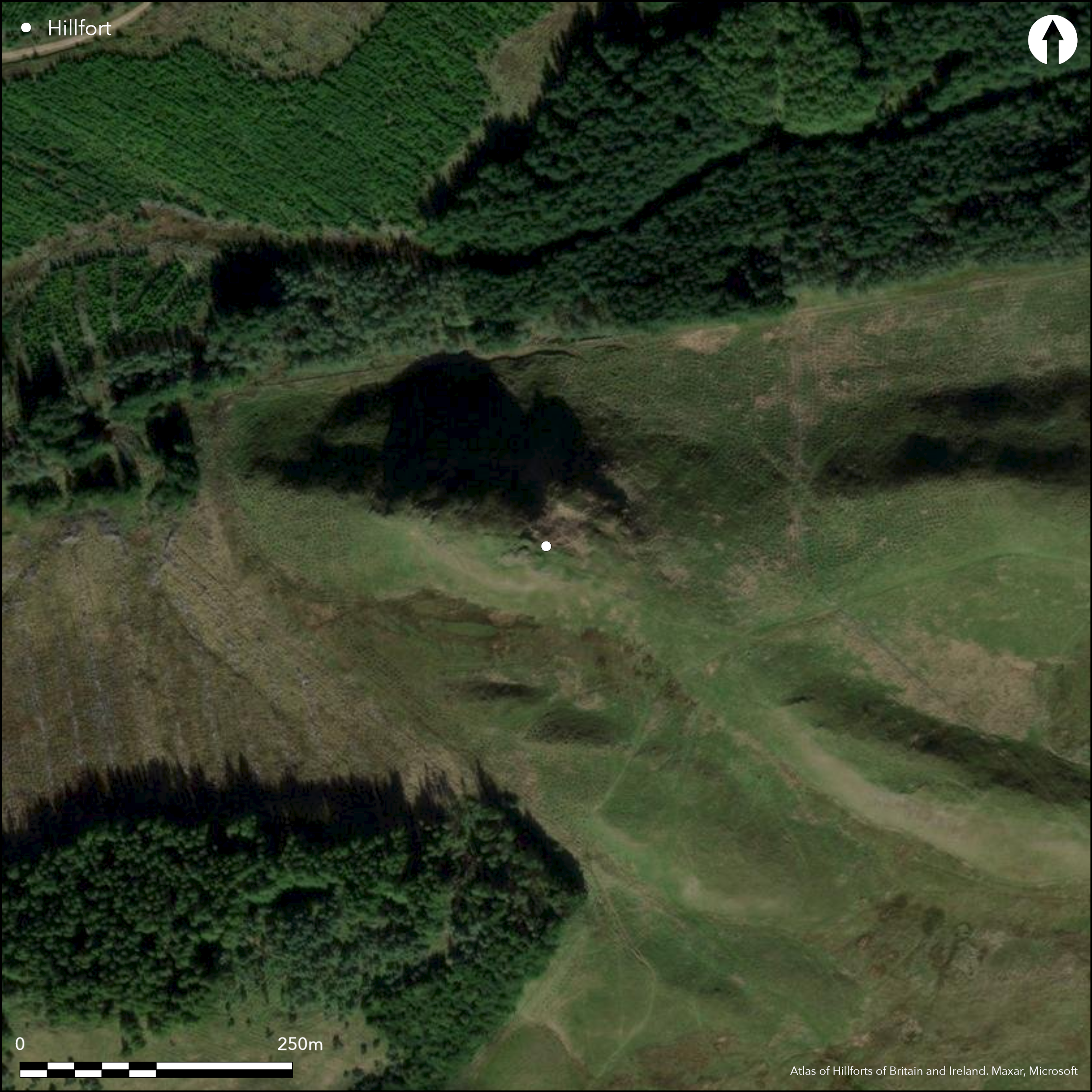
This fort occupies a rocky hillock overlooking the minor public road that traverses the Cleish Hills S of Cleish. The defences are heavily robbed, but they probably comprise two elements: a heavily robbed inner enclosue crowning the summit of the hillock; and an irregular outer enclosure taking in the terraces to either side of the summit on the E and W respectively. The rocky interior of the inner enclosure measures about 25m from E to W by 14m transversely (0.03ha) within a wall reduced to little more than a band of disturbance some 3m wide where the stones have been removed to its very foundations; in 1952 RCAHMS investigators identified three pieces of vitrified stone in the line of this wall on the N. The outer enclosure, which they and the OS regarded as the fort itself, measures internally about 64m in length and tapers from a maximum of 20m in breadth at the E end to no more than 14m on the W (0.1ha). At the W end, where the RCAHMS investigators believed there was an entrance, the rampart is reduced to a stony scarp drawn in a shallow arc between the crags on the N and S respectively, but at the E end it is much better preserved, following the S margin of the hillock before turning sharply northwards across its spine and dropping down to what is probably an entrance on the E; numerous outer facing stones are visible along its line, in places standing two courses high, and there are also several stones of the inner face, indicating a thickness of about 3m. The course of the rampart beyond the entrance is less certain, and while there is a scatter of loose stones along the N margin of the hillock, there are also traces of a rampart extending along a lower terrace on this flank, though this latter appears to extend eastwards beyond the position of the entrance. The interior is featureless.
Citizen Science: ✗
Reliability of Data: Confirmed
Reliability of Interpretation: Confirmed
X: -386127 Y: 7589410 (EPSG: 3857)
Longitude: -3.4686357927836546 Latitude: 56.15537949788392 (EPSG:4326)
Country: Scotland
Current County or Unitary Authority: Perth & Kinross
Historic County: Kinross-shire
Current Parish/Community/Council/Townland: Cleish
None
| Extant | ✓ |
| Cropmark | ✗ |
| Likely Destroyed | ✗ |
None
| Woodland | ✗ |
| Commercial Forestry Plantation | ✗ |
| Parkland | ✗ |
| Pasture (Grazing) | ✓ |
| Arable | ✗ |
| Scrub/Bracken | ✗ |
| Bare Outcrop | ✗ |
| Heather/Moorland | ✓ |
| Heath | ✗ |
| Built-up | ✗ |
| Coastal Grassland | ✗ |
| Other | ✗ |
None
| Contour Fort | ✓ |
| Partial Contour Fort | ✗ |
| Promontory Fort | ✗ |
| Hillslope Fort | ✗ |
| Level Terrain Fort | ✗ |
| Marsh Fort | ✗ |
| Multiple Enclosure Fort | ✗ |
| Hilltop | ✗ |
| Coastal Promontory | ✗ |
| Inland Promontory | ✗ |
| Valley Bottom | ✗ |
| Knoll/Hillock/Outcrop | ✓ |
| Ridge | ✗ |
| Cliff/Plateau-edge/Scarp | ✗ |
| Hillslope | ✗ |
| Lowland | ✗ |
| Spur | ✗ |
Dominant Topographic Feature: None
| North | ✗ |
| Northeast | ✗ |
| East | ✗ |
| Southeast | ✗ |
| South | ✗ |
| Southwest | ✗ |
| West | ✗ |
| Northwest | ✗ |
| Level | ✓ |
Altitude: 305.0m
N/A
In the absence of excavation, there are neither stratified artefacts nor radiocarbon dates to provide a chronology for the defences.
Reliability: D - None
| Pre 1200BC | ✗ |
| 1200BC - 800BC | ✗ |
| 800BC - 400BC | ✗ |
| 400BC - AD50 | ✗ |
| AD50 - AD400 | ✗ |
| AD400 - AD 800 | ✗ |
| Post AD800 | ✗ |
| Unknown | ✓ |
| Pre Hillfort: | None |
| Post Hillfort: | Stone robbing |
None
| 1st Identified Map Depiction (1854): | Annotated Fort on 1st edition OS 6-inch map (Fife, 1856, sheet 30) |
| Other (1927): | Description (RCAHMS 1933, 290, no.548) |
| Earthwork Survey (1952): | Plan and description (RCAHMS KRD 11/1-2 & DP160418-9; Feachem 1963, 128-9) |
| Other (1974): | Surveyed at 1:10,000 by the OS |
| Other (1991): | Description by RCAHMS (SH) |
Featureless apart from the inner summit enclosure
None
| None | ✓ |
| Spring | ✗ |
| Stream | ✗ |
| Pool | ✗ |
| Flush | ✗ |
| Well | ✗ |
| Other | ✗ |
None
| No Known Features | ✓ |
| Round Stone Structures | ✗ |
| Rectangular Stone Structures | ✗ |
| Curvilinear Platforms | ✗ |
| Other Roundhouse Evidence | ✗ |
| Pits | ✗ |
| Quarry Hollows | ✗ |
| Other | ✗ |
None
| No Known Excavation | ✓ |
| Pits | ✗ |
| Postholes | ✗ |
| Roundhouses | ✗ |
| Rectangular Structures | ✗ |
| Roads/Tracks | ✗ |
| Quarry Hollows | ✗ |
| Other | ✗ |
| Nothing Found | ✗ |
None
| No Known Geophysics | ✓ |
| Pits | ✗ |
| Roundhouses | ✗ |
| Rectangular Structures | ✗ |
| Roads/Tracks | ✗ |
| Quarry Hollows | ✗ |
| Other | ✗ |
| Nothing Found | ✗ |
None
| No Known Finds | ✓ |
| Pottery | ✗ |
| Metal | ✗ |
| Metalworking | ✗ |
| Human Bones | ✗ |
| Animal Bones | ✗ |
| Lithics | ✗ |
| Environmental | ✗ |
| Other | ✗ |
NO APPARENT FEATURES
| APs Not Checked | ✗ |
| None | ✓ |
| Roundhouses | ✗ |
| Rectangular Structures | ✗ |
| Pits | ✗ |
| Postholes | ✗ |
| Roads/Tracks | ✗ |
| Other | ✗ |
See main summary
| 1: | The rampart is only intermittently visible |
| 2: | None |
Guard Chambers: ✗
Chevaux de Frise: ✗
| 1. Simple Gap (East): | None |
One rampart intermittently along the margins of the hillock
| Area 1: | 0.1ha. |
| Total: | 0.1ha. |
Total Footprint Area: Noneha.
None
| ✗ | None |
| ✗ | This excludes the summit enclosure |
| NE Quadrant: | 2 |
| SE Quadrant: | 1 |
| SW Quadrant: | 0 |
| NW Quadrant: | 1 |
| Total: | 2 |
| Partial Univallate | ✓ |
| Univallate | ✗ |
| Partial Bivallate | ✓ |
| Bivallate | ✗ |
| Partial Multivallate | ✗ |
| Multivallate | ✗ |
| Unknown | ✗ |
| Partial Univallate | ✗ |
| Univallate | ✗ |
| Partial Bivallate | ✗ |
| Bivallate | ✗ |
| Partial Multivallate | ✗ |
| Multivallate | ✗ |
None
| None | ✗ |
| Earthen Bank | ✗ |
| Stone Wall | ✓ |
| Rubble | ✗ |
| Wall-walk | ✗ |
| Evidence of Timber | ✗ |
| Vitrification | ✗ |
| Other Burning | ✗ |
| Palisade | ✗ |
| Counter Scarp Bank | ✗ |
| Berm | ✗ |
| Unfinished | ✗ |
| Other | ✗ |
None
| None | ✗ |
| Earthen Bank | ✗ |
| Stone Wall | ✗ |
| Murus Duplex | ✗ |
| Timber-framed | ✗ |
| Timber-laced | ✗ |
| Vitrification | ✗ |
| Other Burning | ✗ |
| Palisade | ✗ |
| Counter Scarp Bank | ✗ |
| Berm | ✗ |
| Unfinished | ✗ |
| No Known Excavation | ✓ |
| Other | ✗ |
| ✗ | None |
| ✗ | None |
Number of Ditches: None
| ✗ | None |
Feachem, R W (1963) A guide to prehistoric Scotland. Batsford: London
RCAHMS. (1933) The Royal Commission on the Ancient and Historical Monuments and Constructions of Scotland. Eleventh report with inventory of monuments and constructions in the counties of Fife, Kinross, and Clackmannan. HMSO: Edinburgh
Atlas of Hillforts:
Wikidata:
This work is licensed under CC BY-SA 4.0![]()
![]()
![]() and should be cited as:
and should be cited as:
Lock, Gary and Ralston, Ian. 2024. Atlas of Hillforts of Britain and Ireland. Available at: https://hillforts.arch.ox.ac.uk
Document Version 1.1