LiDAR 1m DTM Hillshade

Satellite Imagery
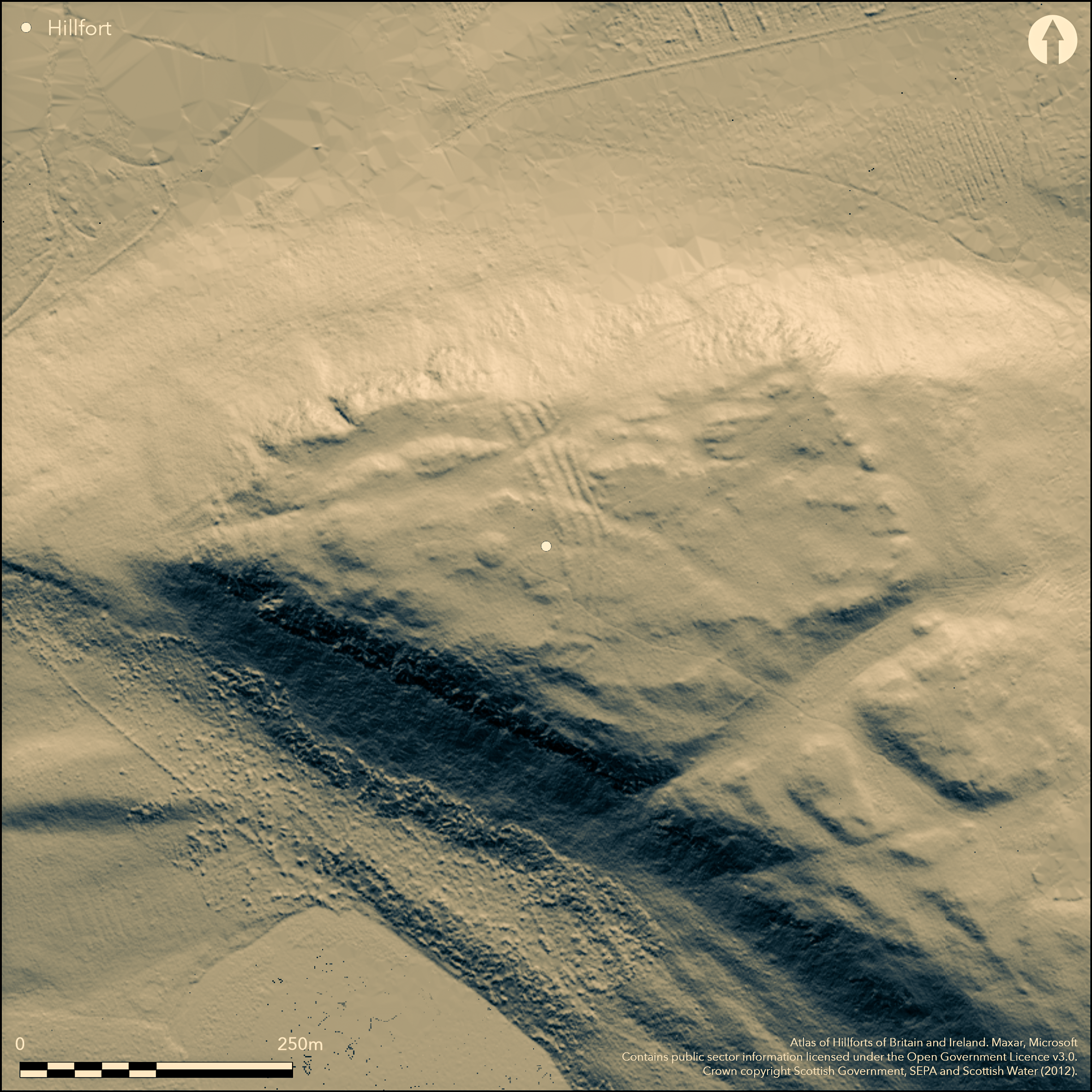
LiDAR 1m DTM Hillshade
Satellite Imagery
Scroll left/right to view further images.
HER: Perth and Kinross Heritage Trust MPK5647 (None)
NMR: NT 09 NE 2 (49629)
SM: 992
NGR: NT 0762 9650
X: 307620 Y: 696500 (OSGB36)
This unusual fort, which occupies the W end of the summit area of Dumglow, on the northern fringe of the Cleish Hills, is configured as a promontory fortification, with its belt of four ramparts some 25m deep barring access from the E and no evidence of a rampart extending around its craggy margin on the N or S. The triangular interior measures about 150m from E to W by a maximum of 130m transversely at the E end. The ramparts are relatively slight, and the three outer ones are separated by shallow ditches. A well-defined entrance lies at the N end of the defences, where the outer ramparts apparently return and unite around the terminals of the ditches to form an entrance passage. The plan surveyed in 1927 by Charles Calder (RCAHMS 1933, 290, no.549, fig 453), fails to show these returns, merely terminating the ramparts to either side of the gap, but a second entrance is shown with this feature at the S end of the defences, albeit that this sector is heavily disturbed and it is not clear in its present state whether there was originally a gap here. Apart from a large circular burial cairn occupying the very summit of the hill, parially excavated by Abercromby in 1904, the interior is featureless. In 1991, RCAHMS investigators raised the possibility that there was an outlying rampart enclosing a much larger area on the E, but a revisit (SH) in 2014 dismissed this as a natural feature.
Citizen Science: ✗
Reliability of Data: Confirmed
Reliability of Interpretation: Confirmed
X: -388359 Y: 7588785 (EPSG: 3857)
Longitude: -3.488688821988998 Latitude: 56.15225511722646 (EPSG:4326)
Country: Scotland
Current County or Unitary Authority: Perth & Kinross
Historic County: Kinross-shire
Current Parish/Community/Council/Townland: Cleish
None
| Extant | ✓ |
| Cropmark | ✗ |
| Likely Destroyed | ✗ |
None
| Woodland | ✗ |
| Commercial Forestry Plantation | ✗ |
| Parkland | ✗ |
| Pasture (Grazing) | ✗ |
| Arable | ✗ |
| Scrub/Bracken | ✗ |
| Bare Outcrop | ✗ |
| Heather/Moorland | ✓ |
| Heath | ✗ |
| Built-up | ✗ |
| Coastal Grassland | ✗ |
| Other | ✗ |
None
| Contour Fort | ✗ |
| Partial Contour Fort | ✗ |
| Promontory Fort | ✓ |
| Hillslope Fort | ✗ |
| Level Terrain Fort | ✗ |
| Marsh Fort | ✗ |
| Multiple Enclosure Fort | ✗ |
| Hilltop | ✓ |
| Coastal Promontory | ✗ |
| Inland Promontory | ✓ |
| Valley Bottom | ✗ |
| Knoll/Hillock/Outcrop | ✗ |
| Ridge | ✗ |
| Cliff/Plateau-edge/Scarp | ✗ |
| Hillslope | ✗ |
| Lowland | ✗ |
| Spur | ✗ |
Dominant Topographic Feature: None
| North | ✗ |
| Northeast | ✗ |
| East | ✗ |
| Southeast | ✗ |
| South | ✗ |
| Southwest | ✗ |
| West | ✗ |
| Northwest | ✗ |
| Level | ✓ |
Altitude: 379.0m
N/A
In the absence of modern excavation, there are neither stratified artefacts nor radiocarbon dates to provide a chronology for the defences.
Reliability: D - None
| Pre 1200BC | ✗ |
| 1200BC - 800BC | ✗ |
| 800BC - 400BC | ✗ |
| 400BC - AD50 | ✗ |
| AD50 - AD400 | ✗ |
| AD400 - AD 800 | ✗ |
| Post AD800 | ✗ |
| Unknown | ✓ |
| Pre Hillfort: | Bronze Age round cairn stands within the interior; excavations by John Abercromby found a hollowed tree trunk in the cairn (1905) |
| Post Hillfort: | Beacons have been lit on the cairn within the interior |
Photographed by RCAHMS Aerial Survey Programme in 1981, 1983, 1991 and 2013
| 1st Identified Map Depiction (1854): | Annotated 'Supposed British Fastness' in italics on the 1st edition OS 6-inch map (Fife 1856, sheet 30; Name Book, Kinross-shire, No.4, p 33) |
| Other (1903): | Noted by John Abercromby (1905, 179) |
| Excavation (1904): | Of the cairn by John Abercromby (1905, 179-81) |
| Earthwork Survey (1927): | Plan and description (RCAHMS 1933, 290, no.549, fig 453; RCAHMS KRD 4/1-2 & DP053138, DP160417) |
| Other (1936): | Scheduled |
| Other (1951): | Visited during RCAHMS Survey of Marginal Lands (Feachem 1963, 129) |
| Other (1974): | Surveyed at 1:10,000 by the OS |
| Other (1991): | Description by RCAHMS (SH) |
| Other (2014): | Visited by SH to review (and discard) a possible outer enclosure |
Featureless apart from the cairn
None
| None | ✓ |
| Spring | ✗ |
| Stream | ✗ |
| Pool | ✗ |
| Flush | ✗ |
| Well | ✗ |
| Other | ✗ |
None
| No Known Features | ✓ |
| Round Stone Structures | ✗ |
| Rectangular Stone Structures | ✗ |
| Curvilinear Platforms | ✗ |
| Other Roundhouse Evidence | ✗ |
| Pits | ✗ |
| Quarry Hollows | ✗ |
| Other | ✗ |
None
| No Known Excavation | ✓ |
| Pits | ✗ |
| Postholes | ✗ |
| Roundhouses | ✗ |
| Rectangular Structures | ✗ |
| Roads/Tracks | ✗ |
| Quarry Hollows | ✗ |
| Other | ✗ |
| Nothing Found | ✗ |
None
| No Known Geophysics | ✓ |
| Pits | ✗ |
| Roundhouses | ✗ |
| Rectangular Structures | ✗ |
| Roads/Tracks | ✗ |
| Quarry Hollows | ✗ |
| Other | ✗ |
| Nothing Found | ✗ |
None
| No Known Finds | ✓ |
| Pottery | ✗ |
| Metal | ✗ |
| Metalworking | ✗ |
| Human Bones | ✗ |
| Animal Bones | ✗ |
| Lithics | ✗ |
| Environmental | ✗ |
| Other | ✗ |
NO APPARENT FEATURES
| APs Not Checked | ✗ |
| None | ✓ |
| Roundhouses | ✗ |
| Rectangular Structures | ✗ |
| Pits | ✗ |
| Postholes | ✗ |
| Roads/Tracks | ✗ |
| Other | ✗ |
See main summary
| 2: | None |
| 2: | Only one of the gaps is a clearly defined entrance |
Guard Chambers: ✗
Chevaux de Frise: ✗
| 1. Passage-way/Corridor (North east): | Outer ramparts return and unite to line the entrance way |
Four ramparts cutting off access to the W tip of the hill
| Area 1: | 1.6ha. |
| Total: | 1.6ha. |
Total Footprint Area: Noneha.
None
| ✗ | None |
| ✗ | None |
| NE Quadrant: | 4 |
| SE Quadrant: | 4 |
| SW Quadrant: | 0 |
| NW Quadrant: | 0 |
| Total: | 4 |
| Partial Univallate | ✗ |
| Univallate | ✗ |
| Partial Bivallate | ✗ |
| Bivallate | ✗ |
| Partial Multivallate | ✓ |
| Multivallate | ✗ |
| Unknown | ✗ |
| Partial Univallate | ✗ |
| Univallate | ✗ |
| Partial Bivallate | ✗ |
| Bivallate | ✗ |
| Partial Multivallate | ✗ |
| Multivallate | ✗ |
None
| None | ✗ |
| Earthen Bank | ✓ |
| Stone Wall | ✗ |
| Rubble | ✗ |
| Wall-walk | ✗ |
| Evidence of Timber | ✗ |
| Vitrification | ✗ |
| Other Burning | ✗ |
| Palisade | ✗ |
| Counter Scarp Bank | ✗ |
| Berm | ✗ |
| Unfinished | ✗ |
| Other | ✗ |
None
| None | ✗ |
| Earthen Bank | ✗ |
| Stone Wall | ✗ |
| Murus Duplex | ✗ |
| Timber-framed | ✗ |
| Timber-laced | ✗ |
| Vitrification | ✗ |
| Other Burning | ✗ |
| Palisade | ✗ |
| Counter Scarp Bank | ✗ |
| Berm | ✗ |
| Unfinished | ✗ |
| No Known Excavation | ✓ |
| Other | ✗ |
| ✗ | None |
| ✓ | None |
Number of Ditches: 3
| ✗ | None |
Abercromby, J (1905) 'Report on excavations at Fethaland and Trowie Knowe, Shetland; and of the exploration of a cairn on Dumglow, one of the Cleish Hills, Kinross-shire'. Proc Soc Antiq Scot 39 (1904-5), 171-84
Feachem, R W (1963) A guide to prehistoric Scotland. Batsford: London
Name Book, Ordnance Survey Object Name Books (6 inch and 1/2500 scale); available https://www.scotlandsplaces.gov.uk/
RCAHMS. (1933) The Royal Commission on the Ancient and Historical Monuments and Constructions of Scotland. Eleventh report with inventory of monuments and constructions in the counties of Fife, Kinross, and Clackmannan. HMSO: Edinburgh
Atlas of Hillforts:
Wikidata:
This work is licensed under CC BY-SA 4.0![]()
![]()
![]() and should be cited as:
and should be cited as:
Lock, Gary and Ralston, Ian. 2024. Atlas of Hillforts of Britain and Ireland. Available at: https://hillforts.arch.ox.ac.uk
Document Version 1.1