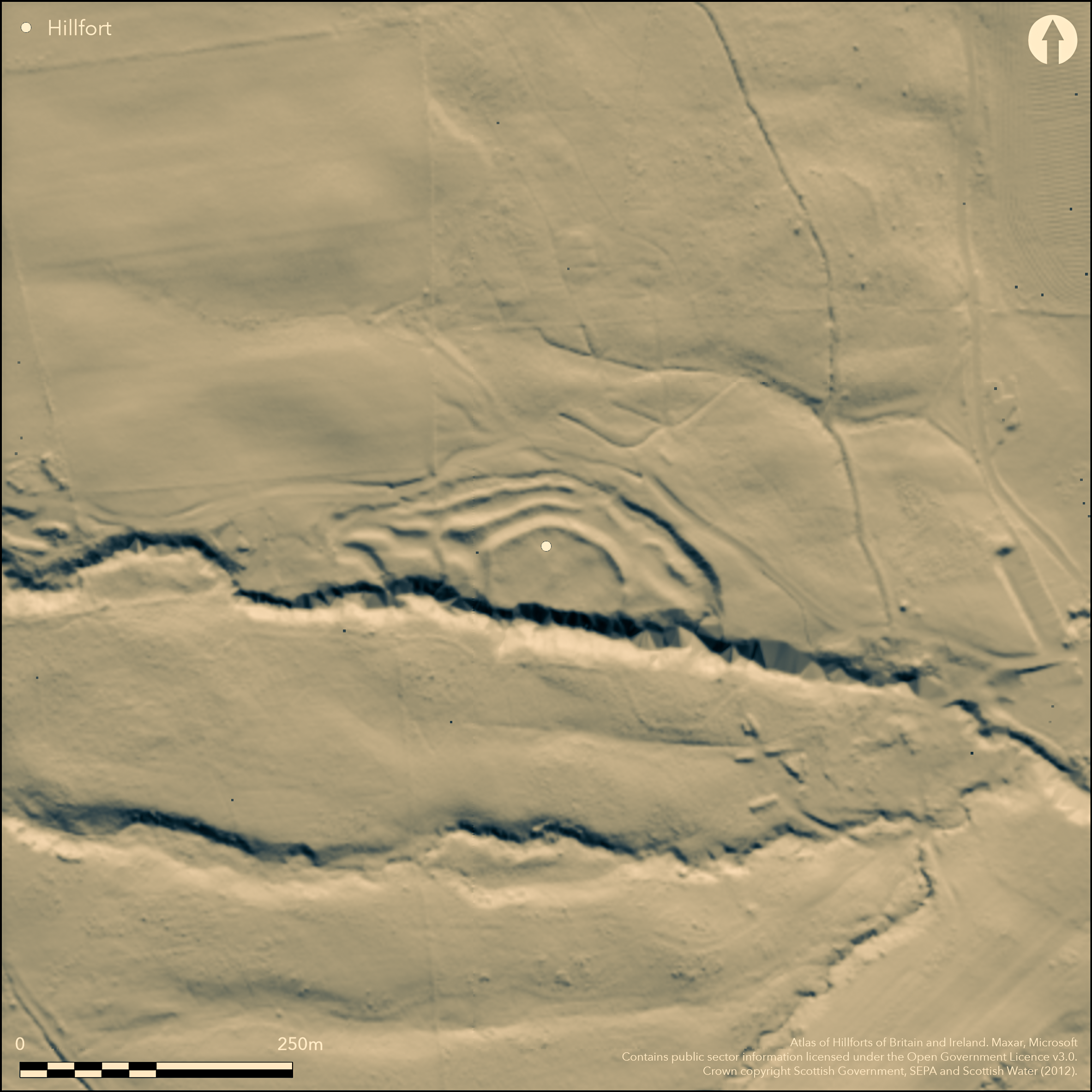
LiDAR 1m DTM Hillshade

Satellite Imagery
LiDAR 1m DTM Hillshade
Satellite Imagery
Scroll left/right to view further images.
HER: Dumfries & Galloway MDG379 (None)
NMR: NT 01 SE 3 (48495)
SM: 654
NGR: NT 0690 1105
X: 306900 Y: 611050 (OSGB36)
The construction of this settlement above Ericstane has harnessed a series of natural channels on the N bank of the Braefoot Linn to create what is in effect a bivallate fortification, though as they appear today most of the features of the defences are largely natural. The interior of the settlement is D shaped on plan, its chord formed by the rocky cleft of Braefoot Linn on the S, and measures about 66m from ESE to WNW by 40m transversely (0.23ha). The inner bank appears to be some 8m in thickness, but is probably largely a scarped natural bank capped by a stone wall 2.4m in thickness by 0.4m in height; a few outer facing-stones are visible on the W and ENE. The ditch outside it is likewise tailored from one of the natural channels on the N, but where it cuts across their grain on the W is up to 10m in breadth by 2m in depth. A further 10m outside it on this side a second ditch with an internal bank has been cut to link the lip of the Braefoot Linn gully to a second channel on the N, though there is little evidence of artificial works extending eastwards, either in the channel itself or the rib separating it from the inner ditch. Indeed, the only evidence of artificial work in the channels around the NE flank is a short arc of bank where a trackway approaching the entrance from the N crosses the inner; the entrance into the interior itself lies on the E, the arrangement of the trackway thus exposing the visitor's right side. The interior has been dug into the slope on the W and contains at least four house platforms, the largest of which is about 9.5m in diameter.
Citizen Science: ✗
Reliability of Data: Confirmed
Reliability of Interpretation: Confirmed
X: -386399 Y: 7436867 (EPSG: 3857)
Longitude: -3.471079954161523 Latitude: 55.38458749792979 (EPSG:4326)
Country: Scotland
Current County or Unitary Authority: Dumfries & Galloway
Historic County: Dumfriesshire
Current Parish/Community/Council/Townland: Moffat
None
| Extant | ✓ |
| Cropmark | ✗ |
| Likely Destroyed | ✗ |
None
| Woodland | ✗ |
| Commercial Forestry Plantation | ✗ |
| Parkland | ✗ |
| Pasture (Grazing) | ✓ |
| Arable | ✗ |
| Scrub/Bracken | ✗ |
| Bare Outcrop | ✗ |
| Heather/Moorland | ✓ |
| Heath | ✗ |
| Built-up | ✗ |
| Coastal Grassland | ✗ |
| Other | ✗ |
None
| Contour Fort | ✗ |
| Partial Contour Fort | ✗ |
| Promontory Fort | ✗ |
| Hillslope Fort | ✓ |
| Level Terrain Fort | ✗ |
| Marsh Fort | ✗ |
| Multiple Enclosure Fort | ✗ |
| Hilltop | ✗ |
| Coastal Promontory | ✗ |
| Inland Promontory | ✗ |
| Valley Bottom | ✗ |
| Knoll/Hillock/Outcrop | ✗ |
| Ridge | ✗ |
| Cliff/Plateau-edge/Scarp | ✓ |
| Hillslope | ✓ |
| Lowland | ✗ |
| Spur | ✗ |
Dominant Topographic Feature: None
| North | ✗ |
| Northeast | ✗ |
| East | ✓ |
| Southeast | ✗ |
| South | ✗ |
| Southwest | ✗ |
| West | ✗ |
| Northwest | ✗ |
| Level | ✗ |
Altitude: 220.0m
N/A
In the absence of excavation, there are neither stratified artefacts nor radiocarbon dates to provide a chronology for the defences.
Reliability: D - None
| Pre 1200BC | ✗ |
| 1200BC - 800BC | ✗ |
| 800BC - 400BC | ✗ |
| 400BC - AD50 | ✗ |
| AD50 - AD400 | ✗ |
| AD400 - AD 800 | ✗ |
| Post AD800 | ✗ |
| Unknown | ✓ |
| Pre Hillfort: | None |
| Post Hillfort: | Overlain by stone dykes |
RCAHMS Aerial Survey programme photographed the site in 1986, 1988, 1991 and 2001, and CUCAP in 1974
| 1st Identified Map Depiction (1857): | Annotated Fort on the 1st edition OS 6-inch map (Dumfriesshire 1861, sheet 9) |
| Earthwork Survey (1890): | Plan and description by David Christison (1891, 232-4, fig 14) |
| Other (1898): | Depicted on the OS 25-inch map (Dumfriesshire 1899, sheet 9.10) |
| Other (1912): | Description by Alexander Curle (RCAHMS 1920, 172-3, no.486) |
| Other (1937): | Scheduled |
| Other (1959): | Visited by the OS |
| Other (1973): | Resurveyed at 1:2500 by the OS |
| Earthwork Survey (1991): | Plan and description (RCAHMS 1997, 135, fig 132; RCAHMS DC32384 & SC 1346440, DC32626, DC32211) |
At least four house platforms in the sccoped interior
None
| None | ✓ |
| Spring | ✗ |
| Stream | ✗ |
| Pool | ✗ |
| Flush | ✗ |
| Well | ✗ |
| Other | ✗ |
At least four house-platforms
| No Known Features | ✗ |
| Round Stone Structures | ✗ |
| Rectangular Stone Structures | ✗ |
| Curvilinear Platforms | ✓ |
| Other Roundhouse Evidence | ✗ |
| Pits | ✗ |
| Quarry Hollows | ✗ |
| Other | ✗ |
None
| No Known Excavation | ✓ |
| Pits | ✗ |
| Postholes | ✗ |
| Roundhouses | ✗ |
| Rectangular Structures | ✗ |
| Roads/Tracks | ✗ |
| Quarry Hollows | ✗ |
| Other | ✗ |
| Nothing Found | ✗ |
None
| No Known Geophysics | ✓ |
| Pits | ✗ |
| Roundhouses | ✗ |
| Rectangular Structures | ✗ |
| Roads/Tracks | ✗ |
| Quarry Hollows | ✗ |
| Other | ✗ |
| Nothing Found | ✗ |
None
| No Known Finds | ✓ |
| Pottery | ✗ |
| Metal | ✗ |
| Metalworking | ✗ |
| Human Bones | ✗ |
| Animal Bones | ✗ |
| Lithics | ✗ |
| Environmental | ✗ |
| Other | ✗ |
NO APPARENT FEATURES
| APs Not Checked | ✗ |
| None | ✓ |
| Roundhouses | ✗ |
| Rectangular Structures | ✗ |
| Pits | ✗ |
| Postholes | ✗ |
| Roads/Tracks | ✗ |
| Other | ✗ |
See main summary
| 1: | None |
| 2: | Staggered gaps |
Guard Chambers: ✗
Chevaux de Frise: ✗
| 1. Oblique (East): | Oblique approach exposing left side by a trackway piercing the outer defences on the NE |
| 1. Simple Gap (East): | Opposed terminals on the inner circuit, though the outer rampart appears to turn inwards on one side |
At least two ramparts and ditches, which adapt a series of natural channels and embankments
| Area 1: | 0.23ha. |
| Total: | 0.23ha. |
Total Footprint Area: Noneha.
None
| ✗ | None |
| ✗ | None |
| NE Quadrant: | 2 |
| SE Quadrant: | 0 |
| SW Quadrant: | 0 |
| NW Quadrant: | 2 |
| Total: | 2 |
| Partial Univallate | ✗ |
| Univallate | ✗ |
| Partial Bivallate | ✓ |
| Bivallate | ✗ |
| Partial Multivallate | ✗ |
| Multivallate | ✗ |
| Unknown | ✗ |
| Partial Univallate | ✗ |
| Univallate | ✗ |
| Partial Bivallate | ✗ |
| Bivallate | ✗ |
| Partial Multivallate | ✗ |
| Multivallate | ✗ |
None
| None | ✗ |
| Earthen Bank | ✓ |
| Stone Wall | ✓ |
| Rubble | ✗ |
| Wall-walk | ✗ |
| Evidence of Timber | ✗ |
| Vitrification | ✗ |
| Other Burning | ✗ |
| Palisade | ✗ |
| Counter Scarp Bank | ✗ |
| Berm | ✗ |
| Unfinished | ✗ |
| Other | ✗ |
None
| None | ✗ |
| Earthen Bank | ✗ |
| Stone Wall | ✗ |
| Murus Duplex | ✗ |
| Timber-framed | ✗ |
| Timber-laced | ✗ |
| Vitrification | ✗ |
| Other Burning | ✗ |
| Palisade | ✗ |
| Counter Scarp Bank | ✗ |
| Berm | ✗ |
| Unfinished | ✗ |
| No Known Excavation | ✓ |
| Other | ✗ |
| ✗ | None |
| ✓ | None |
Number of Ditches: 2
| ✗ | None |
Christison, D (1891) 'A general view of the forts, camps, and motes of Dumfriesshire, with a detailed description of those in Upper Annandale, and an introduction to the study of Scottish motes', Proc Soc Antiq Scot 25 (1890-91), 198-256
RCAHMS (1920) The Royal Commission on the Ancient and Historical Monuments and Constructions of Scotland. Seventh report with inventory of monuments and constructions in the county of Dumfries. HMSO: Edinburgh
RCAHMS (1997) Eastern Dumfriesshire: an archaeological landscape. HMSO: Edinburgh
Atlas of Hillforts:
Wikidata:
This work is licensed under CC BY-SA 4.0![]()
![]()
![]() and should be cited as:
and should be cited as:
Lock, Gary and Ralston, Ian. 2024. Atlas of Hillforts of Britain and Ireland. Available at: https://hillforts.arch.ox.ac.uk
Document Version 1.1