Satellite Imagery
Satellite Imagery
HER: The West of Scotland Archaeology Service 10845 (None)
NMR: NT 02 SW 1 (48578)
SM: 2437
NGR: NT 0133 2286
X: 301330 Y: 622860 (OSGB36)
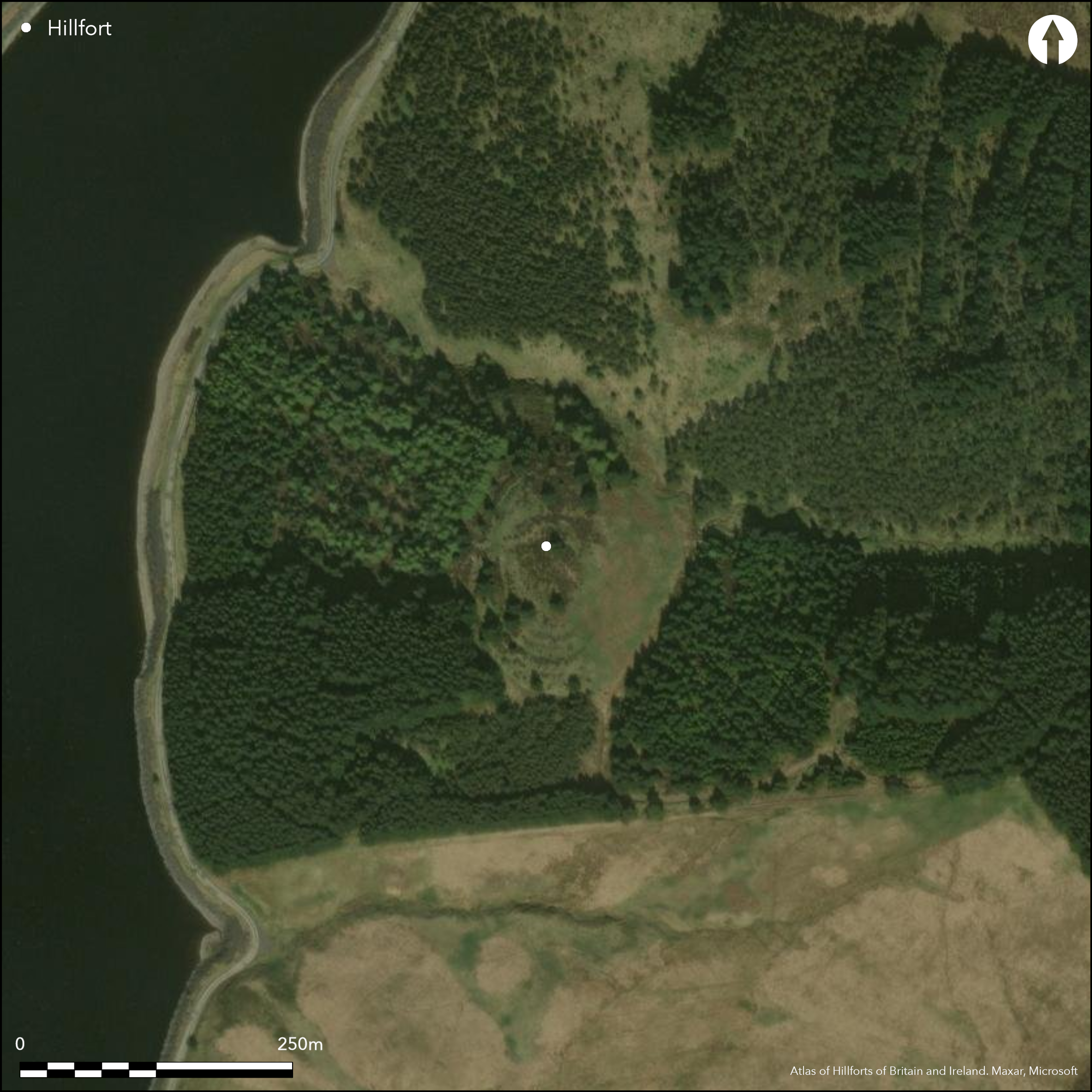
This fort is situated on a steep-sided hillock that rises from the foot of the NW flank of Fairburn Rig, overlooking the upper end of the Camps Water valley, now flooded for a reservoir. Roughly oval on plan, the fort measures 73m from N to S by 54m transversely within the innermost rampart, which can be traced round the summit of the hillock, variously forming a stony bank on the SW and NE, but reduced to a scarp around the SE and NW. On the easiest line of approach, from the S and SW, no fewer than five ramparts are visible, reducing to perhaps four on the steeper NW slope, and two where the ground falls away particularly sharply along the E flank. The precise sequence of construction of the ramparts is uncertain, but on plan at least it appears that the two inner ramparts on the SW are the latest, forming part of a coherent scheme in which they return and unite around the terminal of a medial ditch on the S side of the entrance on the W. The outer of the two apparently overlies the back of an earlier rampart further down the slope, which has been reduced to a scarp immediately outside its line, dropping into the bottom of an external ditch with a counterscarp bank. But while this earlier rampart with its ditch and counterscarp bank are replicated in the arrangement of the defences to the N of the entrance, the two innermost ramparts of the later scheme are not and there is but a single rampart to represent them, and this reduced to a scarp. Evidently the complexities in these arrangements will only be understood through excavation, but a fifth rampart lying a little further down the slope on the SW, with an internal quarry scoop and an external ditch, is likely to have been an addition to the outer defences. It peters out northwards short of the entrance on the W, though there are traces of a short segment of ditch with a counterscarp bank on the NW. In addition to the entrance on the W, in which there are traces of a worn hollow dropping down between the terminals of the ramparts, there is a second entrance on the SE; here the terminals of the innermost rampart turn inwards slightly to either side of the gap and there is evidence of a track approaching obliquely up the slope to expose the visitor's left side. Traces of at least five house platforms can be seen in the N half of the interior, but the ground has been so heavily disturbed by forestry operations there may well have been others.
Citizen Science: ✗
Reliability of Data: Confirmed
Reliability of Interpretation: Confirmed
X: -396648 Y: 7457469 (EPSG: 3857)
Longitude: -3.563151535939004 Latitude: 55.489580084992994 (EPSG:4326)
Country: Scotland
Current County or Unitary Authority: South Lanarkshire
Historic County: Lanarkshire
Current Parish/Community/Council/Townland: Crawford
None
| Extant | ✓ |
| Cropmark | ✗ |
| Likely Destroyed | ✗ |
Having been under a plantation, it now lies in a heather and grass-grown clearing
| Woodland | ✗ |
| Commercial Forestry Plantation | ✗ |
| Parkland | ✗ |
| Pasture (Grazing) | ✗ |
| Arable | ✗ |
| Scrub/Bracken | ✗ |
| Bare Outcrop | ✗ |
| Heather/Moorland | ✓ |
| Heath | ✗ |
| Built-up | ✗ |
| Coastal Grassland | ✗ |
| Other | ✗ |
None
| Contour Fort | ✓ |
| Partial Contour Fort | ✗ |
| Promontory Fort | ✗ |
| Hillslope Fort | ✗ |
| Level Terrain Fort | ✗ |
| Marsh Fort | ✗ |
| Multiple Enclosure Fort | ✗ |
| Hilltop | ✗ |
| Coastal Promontory | ✗ |
| Inland Promontory | ✗ |
| Valley Bottom | ✗ |
| Knoll/Hillock/Outcrop | ✓ |
| Ridge | ✗ |
| Cliff/Plateau-edge/Scarp | ✗ |
| Hillslope | ✗ |
| Lowland | ✗ |
| Spur | ✗ |
Dominant Topographic Feature: None
| North | ✗ |
| Northeast | ✗ |
| East | ✗ |
| Southeast | ✗ |
| South | ✗ |
| Southwest | ✗ |
| West | ✗ |
| Northwest | ✗ |
| Level | ✓ |
Altitude: 380.0m
N/A
In the absence of excavation, there are neither stratified artefacts nor radiocarbon dates to provide a chronology for the defences.
Reliability: D - None
| Pre 1200BC | ✗ |
| 1200BC - 800BC | ✗ |
| 800BC - 400BC | ✗ |
| 400BC - AD50 | ✗ |
| AD50 - AD400 | ✗ |
| AD400 - AD 800 | ✗ |
| Post AD800 | ✗ |
| Unknown | ✓ |
| Pre Hillfort: | None |
| Post Hillfort: | Planted with trees, although now in a clearing |
None
| 1st Identified Map Depiction (1859): | Annotated Camp on the 1st edition OS 6-inch map (Lanarkshire 1863, sheet 47) |
| Earthwork Survey (1864): | Sketch-plan and description (Irving and Murray 1864, 10, fig 2) |
| Earthwork Survey (1889): | Plan and description by David Christison (1890, 299-301, fig 5) |
| Other (1959): | Visited by the OS under dense coniferous plantation |
| Other (1964): | Scheduled |
| Other (1970): | Description (RCAHMS 1978, 96-7, no.221) |
| Earthwork Survey (1980): | PLan and description after the plantation was cleared (RCAHMS LAD 222/1-2 & SC337271; Also RCAHMS record sheet MS453/21) |
| Other (1993): | Visited by WOSAS for woodland management |
Traces of up to five house-platforms
None
| None | ✓ |
| Spring | ✗ |
| Stream | ✗ |
| Pool | ✗ |
| Flush | ✗ |
| Well | ✗ |
| Other | ✗ |
None
| No Known Features | ✗ |
| Round Stone Structures | ✗ |
| Rectangular Stone Structures | ✗ |
| Curvilinear Platforms | ✓ |
| Other Roundhouse Evidence | ✗ |
| Pits | ✗ |
| Quarry Hollows | ✗ |
| Other | ✗ |
None
| No Known Excavation | ✓ |
| Pits | ✗ |
| Postholes | ✗ |
| Roundhouses | ✗ |
| Rectangular Structures | ✗ |
| Roads/Tracks | ✗ |
| Quarry Hollows | ✗ |
| Other | ✗ |
| Nothing Found | ✗ |
None
| No Known Geophysics | ✓ |
| Pits | ✗ |
| Roundhouses | ✗ |
| Rectangular Structures | ✗ |
| Roads/Tracks | ✗ |
| Quarry Hollows | ✗ |
| Other | ✗ |
| Nothing Found | ✗ |
None
| No Known Finds | ✓ |
| Pottery | ✗ |
| Metal | ✗ |
| Metalworking | ✗ |
| Human Bones | ✗ |
| Animal Bones | ✗ |
| Lithics | ✗ |
| Environmental | ✗ |
| Other | ✗ |
NO APPARENT FEATURES
| APs Not Checked | ✗ |
| None | ✓ |
| Roundhouses | ✗ |
| Rectangular Structures | ✗ |
| Pits | ✗ |
| Postholes | ✗ |
| Roads/Tracks | ✗ |
| Other | ✗ |
See main summary
| 2: | None |
| 2: | None |
Guard Chambers: ✗
Chevaux de Frise: ✗
| 1. In-turned (South east): | Shallow inturns to either side of a trackway, possibly caused by the oblique approach of a trackway exposing the left side |
| 1. Oblique (South east): | None |
| 2. Passage-way/Corridor (West): | A hollowed track leading between the terminals of three ramparts |
| 2. Oblique (West): | Slightly oblique approach exposing the right side |
At least four ramparts around the easiest line of approach, reducing to two elsewhere, but probably representing at least two periods of construction.
| Area 1: | 0.27ha. |
| Total: | 0.27ha. |
Total Footprint Area: 0.75ha.
None
| ✓ | The two inner ramparts on the SW quarter return and unite around the terminal of the medial ditch at the entrance on the W, but the outer appears to overlie the back of a rampart immediately outside it. |
| ✓ | None |
| NE Quadrant: | 2 |
| SE Quadrant: | 2 |
| SW Quadrant: | 5 |
| NW Quadrant: | 4 |
| Total: | 5 |
| Partial Univallate | ✗ |
| Univallate | ✗ |
| Partial Bivallate | ✓ |
| Bivallate | ✗ |
| Partial Multivallate | ✓ |
| Multivallate | ✗ |
| Unknown | ✗ |
| Partial Univallate | ✗ |
| Univallate | ✗ |
| Partial Bivallate | ✗ |
| Bivallate | ✓ |
| Partial Multivallate | ✗ |
| Multivallate | ✗ |
None
| None | ✗ |
| Earthen Bank | ✓ |
| Stone Wall | ✗ |
| Rubble | ✗ |
| Wall-walk | ✗ |
| Evidence of Timber | ✗ |
| Vitrification | ✗ |
| Other Burning | ✗ |
| Palisade | ✗ |
| Counter Scarp Bank | ✗ |
| Berm | ✗ |
| Unfinished | ✗ |
| Other | ✗ |
None
| None | ✗ |
| Earthen Bank | ✗ |
| Stone Wall | ✗ |
| Murus Duplex | ✗ |
| Timber-framed | ✗ |
| Timber-laced | ✗ |
| Vitrification | ✗ |
| Other Burning | ✗ |
| Palisade | ✗ |
| Counter Scarp Bank | ✗ |
| Berm | ✗ |
| Unfinished | ✗ |
| No Known Excavation | ✓ |
| Other | ✗ |
| ✗ | None |
| ✓ | On the SW, but no more than two elsewhere |
Number of Ditches: 4
| ✗ | None |
Christison, D (1890) 'Forts, camps, and motes of the Upper Ward of Lanarkshire'. Proc Soc Antiq Scot 24 (1889-90), 281-352
Irving and Murray, G V and A (1864) The upper ward of Lanarkshire described and delineated, 3v Glasgow
RCAHMS. (1978) The Royal Commission on the Ancient and Historical Monuments of Scotland. Lanarkshire: an inventory of the prehistoric and Roman monuments. HMSO: Edinburgh
Atlas of Hillforts:
Wikidata:
This work is licensed under CC BY-SA 4.0![]()
![]()
![]() and should be cited as:
and should be cited as:
Lock, Gary and Ralston, Ian. 2024. Atlas of Hillforts of Britain and Ireland. Available at: https://hillforts.arch.ox.ac.uk
Document Version 1.1