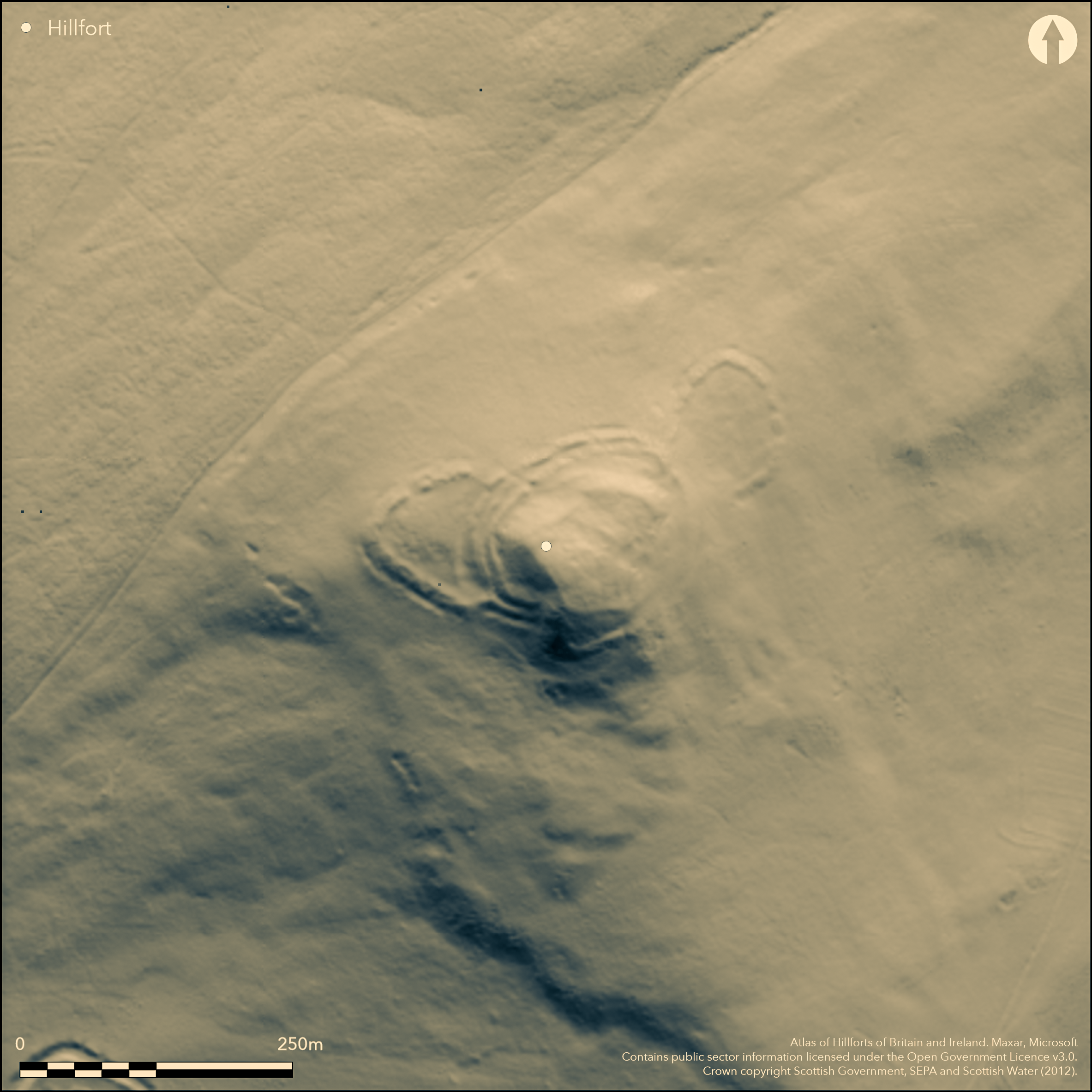
LiDAR 1m DTM Hillshade
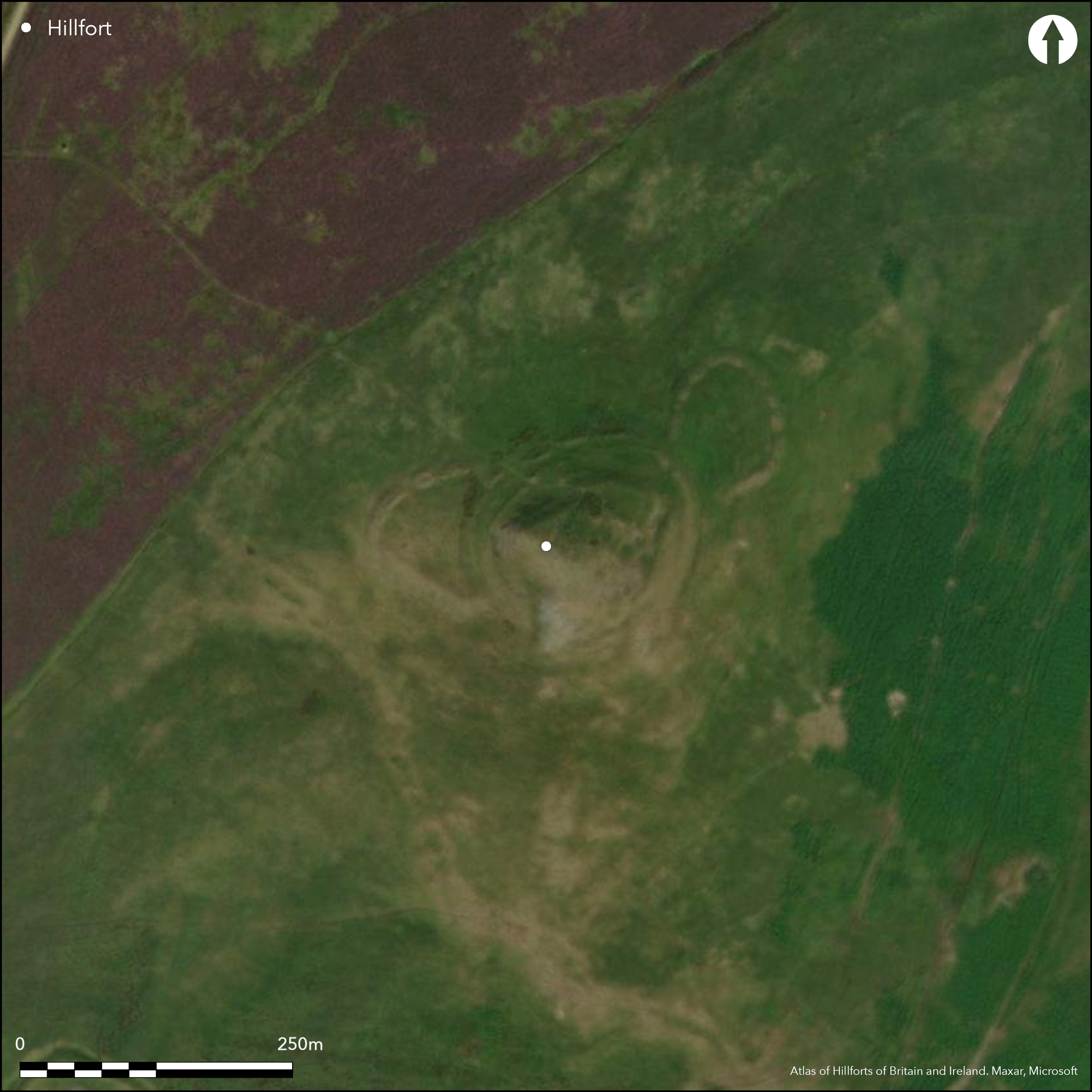
Satellite Imagery
LiDAR 1m DTM Hillshade
Satellite Imagery
Scroll left/right to view further images.
HER: Scottish Borders 54052 (None)
NMR: NT 40 NE 5 (54052)
SM: 2296
NGR: NT 4907 0623
X: 349070 Y: 606230 (OSGB36)
The conical summit of Penchrise Pen, which is a distinctive and prominent landmark in the locality, is crowned by a fort with up to three ramparts, the outer of which on the W is accompanied by an external ditch set at the foot of the slope. Oval on plan, the interior measures about 100m from NE to SW by 75m transversely (0.55ha) and on the NE rises in two broad shelves up to the summit. Apart from where they run up against a bare and craggy outcrop on the S, the defences have probably been continuous, the ramparts forming low banks in the N sector, though they have been reduced to scarps on the steeper slopes elsewhere. In addition to the ditch below the outermost rampart on the W, another short segment can be seen on the N, not only suggesting that this ditch may have been a more continuous feature, but that the stepped profile of the defences may also hide quarry ditches between the lines elsewhere. While the defences have probably formed a continuous circuit, the number of ramparts varies, the outer on the W dividing into two create a belt of three 20m deep flanking the SW side of the entrance on the NW; on opposite side there are only two, which extend round the relatively accessible N flank to a second entrance on the NE. At the latter the entrance-way approaches obliquely up the slope to expose the visitor's right side, and a terrace to the rear of the inner rampart continues up the slope to the lower shelf in the interior. The approach to the NW entrance is more direct, but again there is a clear route mounting the slope to the lower shelf, passing an isolated length of bank on the N side of the interior. Apart from this bank and traces of internal quarrying to the rear of the inner rampart, the only features visible within the interior are a low ring-bank on the lower terrace and a platform cut into the slope on the SE. While it is not possible to identify any stratigraphic relationships between the ramparts, variations in the composition of the defences around the circuit may reflect several periods of construction and refurbishment. This is certainly the case with the two enclosures attached on the W and NE respectively, both of which ride over the outermost defences, that on the NE also impinging on the entrance way which climbs the slope obliquely on this side. The latter enclosure is oval on plan and measures about 65m from N to S by 49m transversely (0.24ha) within a bank that is accompanied on the NE by an external ditch; its entrance is on the NE. The enclosure on the W springs from the outer rampart on the WSW to cross the ditch at the foot of the slope and take in a triangular area measuring up to 63m from N to S by 45m transversely (0.22ha) within a thick bank accompanied by an external ditch; its entrance is on the NNW and traces of at least three ring-ditch houses can be seen in the interior.
Citizen Science: ✗
Reliability of Data: Confirmed
Reliability of Interpretation: Confirmed
X: -312215 Y: 7429598 (EPSG: 3857)
Longitude: -2.8046726900664685 Latitude: 55.347475851249385 (EPSG:4326)
Country: Scotland
Current County or Unitary Authority: Scottish Borders
Historic County: Roxburghshire
Current Parish/Community/Council/Townland: Cavers
None
| Extant | ✓ |
| Cropmark | ✗ |
| Likely Destroyed | ✗ |
None
| Woodland | ✗ |
| Commercial Forestry Plantation | ✗ |
| Parkland | ✗ |
| Pasture (Grazing) | ✓ |
| Arable | ✗ |
| Scrub/Bracken | ✗ |
| Bare Outcrop | ✗ |
| Heather/Moorland | ✓ |
| Heath | ✗ |
| Built-up | ✗ |
| Coastal Grassland | ✗ |
| Other | ✗ |
None
| Contour Fort | ✓ |
| Partial Contour Fort | ✗ |
| Promontory Fort | ✗ |
| Hillslope Fort | ✗ |
| Level Terrain Fort | ✗ |
| Marsh Fort | ✗ |
| Multiple Enclosure Fort | ✗ |
| Hilltop | ✓ |
| Coastal Promontory | ✗ |
| Inland Promontory | ✗ |
| Valley Bottom | ✗ |
| Knoll/Hillock/Outcrop | ✗ |
| Ridge | ✗ |
| Cliff/Plateau-edge/Scarp | ✗ |
| Hillslope | ✗ |
| Lowland | ✗ |
| Spur | ✗ |
Dominant Topographic Feature: Distinctive conical landmark
| North | ✗ |
| Northeast | ✗ |
| East | ✗ |
| Southeast | ✗ |
| South | ✗ |
| Southwest | ✗ |
| West | ✗ |
| Northwest | ✗ |
| Level | ✓ |
Altitude: 439.0m
N/A
In the absence of excavation, there are neither stratified artefacts nor radiocarbon dates to provide a chronology for the defences.
Reliability: D - None
| Pre 1200BC | ✗ |
| 1200BC - 800BC | ✗ |
| 800BC - 400BC | ✗ |
| 400BC - AD50 | ✗ |
| AD50 - AD400 | ✗ |
| AD400 - AD 800 | ✗ |
| Post AD800 | ✗ |
| Unknown | ✓ |
| Pre Hillfort: | None |
| Post Hillfort: | Overlain by two enclosures, one of which contains traces of ring-ditch houses |
Photographed by RCAHMS Aerial Survey Programme in 1981, 1984 and 2010.
| 1st Identified Map Depiction (1858): | Annotated Fort on the 1st edition OS 25-inch map (Roxburgh 1863, sheet 32.11) |
| Earthwork Survey (1949): | Plan and description (RCAHMS 1956, 111-12, no.157, fig 147; RCAHMS RXD 97/1-4) |
| Other (1963): | Scheduled |
| Other (1965): | Resurveyed at 1:2500 by the OS |
| Other (1979): | Surveyed at 1:10,000 by the OS |
| Other (1987): | Visited by the Hill-Fort Study Group |
| Other (2015): | Re-Scheduled |
Contains traces of at least one circular platform and a ring-bank, while three ring-ditch houses can be seen in the enclosure overlying the defences on the W
None
| None | ✓ |
| Spring | ✗ |
| Stream | ✗ |
| Pool | ✗ |
| Flush | ✗ |
| Well | ✗ |
| Other | ✗ |
Ring-ditch houses
| No Known Features | ✗ |
| Round Stone Structures | ✗ |
| Rectangular Stone Structures | ✗ |
| Curvilinear Platforms | ✓ |
| Other Roundhouse Evidence | ✓ |
| Pits | ✗ |
| Quarry Hollows | ✓ |
| Other | ✗ |
None
| No Known Excavation | ✓ |
| Pits | ✗ |
| Postholes | ✗ |
| Roundhouses | ✗ |
| Rectangular Structures | ✗ |
| Roads/Tracks | ✗ |
| Quarry Hollows | ✗ |
| Other | ✗ |
| Nothing Found | ✗ |
None
| No Known Geophysics | ✓ |
| Pits | ✗ |
| Roundhouses | ✗ |
| Rectangular Structures | ✗ |
| Roads/Tracks | ✗ |
| Quarry Hollows | ✗ |
| Other | ✗ |
| Nothing Found | ✗ |
None
| No Known Finds | ✓ |
| Pottery | ✗ |
| Metal | ✗ |
| Metalworking | ✗ |
| Human Bones | ✗ |
| Animal Bones | ✗ |
| Lithics | ✗ |
| Environmental | ✗ |
| Other | ✗ |
Visible within both the main fort and the enclosure on the W
| APs Not Checked | ✗ |
| None | ✗ |
| Roundhouses | ✓ |
| Rectangular Structures | ✗ |
| Pits | ✗ |
| Postholes | ✗ |
| Roads/Tracks | ✗ |
| Other | ✗ |
See main summary
| 2: | None |
| 2: | None |
Guard Chambers: ✗
Chevaux de Frise: ✗
| 1. Oblique (North east): | Oblique approach exposing right side |
| 2. Simple Gap (North west): | Flanked on one side by three ramparts and on the other by only two. |
Up to three ramparts encircling the summit of the hill and possibly acompanied by ditches
| Area 1: | 0.55ha. |
| Total: | 0.55ha. |
Total Footprint Area: 1.3ha.
None
| ✓ | The outer enclosures overlie the defences and are excluded from the overall measurement, which otherwise would extend to 0.21ha |
| ✓ | Minor sector where they fail to cross a rock outcrop on the S |
| NE Quadrant: | 2 |
| SE Quadrant: | 3 |
| SW Quadrant: | 3 |
| NW Quadrant: | 3 |
| Total: | 3 |
| Partial Univallate | ✗ |
| Univallate | ✗ |
| Partial Bivallate | ✓ |
| Bivallate | ✗ |
| Partial Multivallate | ✓ |
| Multivallate | ✗ |
| Unknown | ✗ |
| Partial Univallate | ✗ |
| Univallate | ✗ |
| Partial Bivallate | ✗ |
| Bivallate | ✗ |
| Partial Multivallate | ✗ |
| Multivallate | ✗ |
None
| None | ✗ |
| Earthen Bank | ✓ |
| Stone Wall | ✗ |
| Rubble | ✗ |
| Wall-walk | ✗ |
| Evidence of Timber | ✗ |
| Vitrification | ✗ |
| Other Burning | ✗ |
| Palisade | ✗ |
| Counter Scarp Bank | ✗ |
| Berm | ✗ |
| Unfinished | ✗ |
| Other | ✗ |
None
| None | ✗ |
| Earthen Bank | ✗ |
| Stone Wall | ✗ |
| Murus Duplex | ✗ |
| Timber-framed | ✗ |
| Timber-laced | ✗ |
| Vitrification | ✗ |
| Other Burning | ✗ |
| Palisade | ✗ |
| Counter Scarp Bank | ✗ |
| Berm | ✗ |
| Unfinished | ✗ |
| No Known Excavation | ✓ |
| Other | ✗ |
| ✗ | None |
| ✓ | At least one is visible at the foot of the slope on the W and N |
Number of Ditches: 1
| ✓ | A triangular enclosure (0.22ha) on the W containing traces of three ring-ditch houses is commonly described as an annexe, but overlies the outer ramparts. Both it and the enclosure on the NE (0.24ha), therefore, are as likely to represent later occupations, rather than annexes associated with the occupation of the fort. This might explain the different character of the ring-ditch houses visible in the W enclosure, compared with the ring-bank and platform within the fort. |
RCAHMS (1956) The Royal Commission on the Ancient and Historical Monuments of Scotland. An inventory of the ancient and historical monuments of Roxburghshire: with the fourteenth report of the Commission, 2v. HMSO: Edinburgh
Atlas of Hillforts:
Wikidata:
This work is licensed under CC BY-SA 4.0![]()
![]()
![]() and should be cited as:
and should be cited as:
Lock, Gary and Ralston, Ian. 2024. Atlas of Hillforts of Britain and Ireland. Available at: https://hillforts.arch.ox.ac.uk
Document Version 1.1