Satellite Imagery
Satellite Imagery
HER: Scottish Borders 55249 (None)
NMR: NT 51 NE 8 (55249)
SM: 2129
NGR: NT 5803 1557
X: 358030 Y: 615570 (OSGB36)
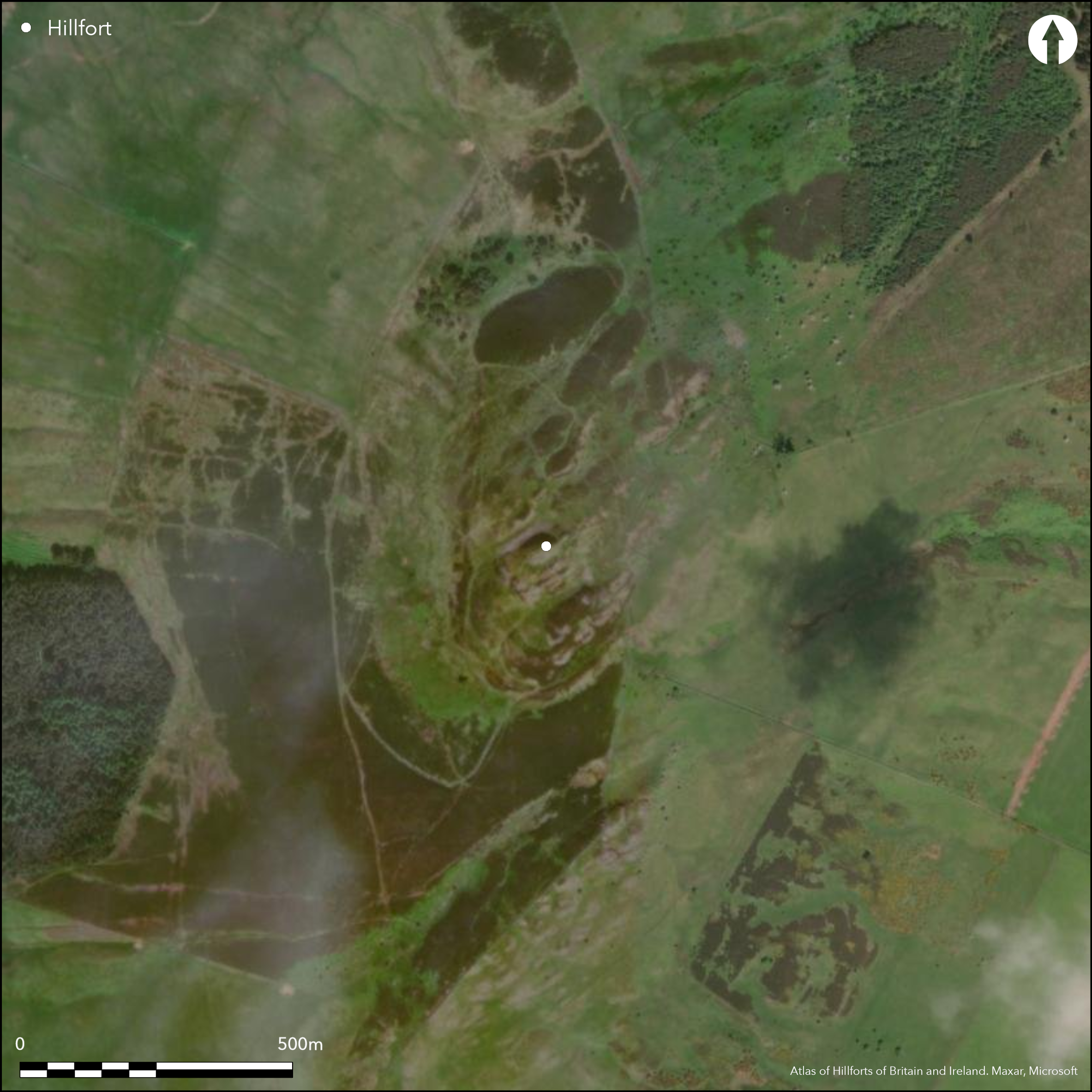
A complex fortification encloses the summit and upper slopes of Rubers Law, a rugged and distinctive landmark between Jedburgh and Hawick. The principal remains can be divided into two elements; a citadel enclosure on the summit, with an annexe taking in a terrace and a rocky ridge on the SE; and a large outer enclosure contouring along natural terraces lower down the slope. The citadel is enclosed by what has been a substantial wall extending round the craggy lip of the summit and measures internally about 72m from ENE to WSW by a maximum of 32m transversely (0.18ha). There is a well-defined entrance at the ENE end, and a possible second at the W end of the SE side, from which a path drops obliquely down the slope into the annexe; the wall at the WSW end is also pierced by a narrow cleft in the rock face known as Peden's Pulpit, but RCAHMS investigators in 1949 did not think this provide a practicable route to the summit. Apart from a mound towards the ENE end of the grassy hollow between the rock outcrops forming the summit area, the interior is featureless; Alexander Curle dug into this mound and beneath a deep layer of soil found a loose heap of stones which he believed was the remains of a rampart, and he also found what he described as a well-defined hut-circle elsewhere (Curle 1907). The wall of the annexe springs from the foot of the summit on the SW and swings round the leading edge of a terrace and along the flank of a rocky ridge to return across a gully at the foot of the summit on the SE. Internally it measures about 90m from ENE to WSW by between 80m and 35m transversely (0.5ha). Its wall is largely reduced to a stony scarp, but where it crosses the gully on the E it forms a mound of rubble about 7m in thickness by 0.6m in height and the massive surviving facing-stones indicate an original thickness in the order of 3.6m; another row of upright stones can be seen 9m in front of the wall in this sector. An entrance on the SW is approached by a hollowed trackway. A notable feature of the walls of both the citadel and the annexe is that they incorporate dressed sandstone blocks which almost certainly derive from a Roman structure, speculated to have been a watchtower on the summit. Several other fragments of walling can be seen to the N of the citadel, which are possibly the remains of outworks controlling access up to the entrance on the ENE. Lower down the slope, however, there are the remains of a heavily ruined rampart contouring round the slope on all sides except the E, essentially following natural terraces and shoulders to form an enclosure of about 3.7ha; an entrance on the S is approached by a hollowed trackway mounting the slope obliquely to expose the visitor's left side, while other entrances possibly utilise two natural gullies on the N .
Citizen Science: ✗
Reliability of Data: Confirmed
Reliability of Interpretation: Confirmed
X: -296644 Y: 7446212 (EPSG: 3857)
Longitude: -2.664798001554673 Latitude: 55.43224571516541 (EPSG:4326)
Country: Scotland
Current County or Unitary Authority: Scottish Borders
Historic County: Roxburghshire
Current Parish/Community/Council/Townland: Cavers
None
Condition:| Extant | ✓ |
| Cropmark | ✗ |
| Likely Destroyed | ✗ |
None
Current Use:| Woodland | ✗ |
| Commercial Forestry Plantation | ✗ |
| Parkland | ✗ |
| Pasture (Grazing) | ✓ |
| Arable | ✗ |
| Scrub/Bracken | ✗ |
| Bare Outcrop | ✗ |
| Heather/Moorland | ✓ |
| Heath | ✗ |
| Built-up | ✗ |
| Coastal Grassland | ✗ |
| Other | ✗ |
The multiple enclosures are probably the result of different periods of construction than a contemporary scheme
Type:| Contour Fort | ✓ |
| Partial Contour Fort | ✗ |
| Promontory Fort | ✗ |
| Hillslope Fort | ✗ |
| Level Terrain Fort | ✗ |
| Marsh Fort | ✗ |
| Multiple Enclosure Fort | ✓ |
| Hilltop | ✓ |
| Coastal Promontory | ✗ |
| Inland Promontory | ✗ |
| Valley Bottom | ✗ |
| Knoll/Hillock/Outcrop | ✗ |
| Ridge | ✗ |
| Cliff/Plateau-edge/Scarp | ✗ |
| Hillslope | ✗ |
| Lowland | ✗ |
| Spur | ✗ |
Dominant Topographic Feature: Prominent landmark commanding wide views
| North | ✗ |
| Northeast | ✗ |
| East | ✗ |
| Southeast | ✗ |
| South | ✗ |
| Southwest | ✗ |
| West | ✗ |
| Northwest | ✗ |
| Level | ✓ |
Altitude: 424.0m
N/A
A complex sequence that is not fully understood in which the site of an earlier fort is occupied by a Roman installation, whose stones were robbed to build a later fort. It is a working assumption that this later phase falls in the early medieval period.
Reliability: D - None
Principal Activity:| Pre 1200BC | ✗ |
| 1200BC - 800BC | ✗ |
| 800BC - 400BC | ✗ |
| 400BC - AD50 | ✗ |
| AD50 - AD400 | ✗ |
| AD400 - AD 800 | ✓ |
| Post AD800 | ✗ |
| Unknown | ✓ |
| Pre Hillfort: | None |
| Post Hillfort: | None |
| Artefactual: | Roman diamond-broached stones are incorporated into the latest ramparts |
Possibly appears on Timothy Pont's map of Nithsdale and part of Teviotdale c.1583-96, though the significance of his depiction of the summit of the hill is uncertain RCAHMS holds an extensive collection of photographs including aerial views taken by CUCAP in 1949 and 1981, Dennis Harding in 1978 and 1982 and by the RCAHMS Aerial Survey Programme in 1980, 1992, 1997 and 2010.
| 1st Identified Written Reference (1836): | Noted (NSA, 3, Roxburghshire, 212) |
| Earthwork Survey (1904): | Description by Alexander Curle and plan by Thomas Ross (Curle 1905, 221, fig 1) |
| Excavation (1906): | By Alexander Curle (1907) |
| 1st Identified Map Depiction (1918): | Annotated Fort on OS 25-inch map (Roxburghshire 1921, sheet n18.16) |
| Earthwork Survey (1949): | Plan and description (RCAHMS 1956, 102-5, no.145, fig 140; RCAHMS RXD 100/1-4) |
| Other (1961): | Scheduled |
| Other (1965): | Surveyed at 1:2500 by the OS |
Featureless
None
Source:| None | ✓ |
| Spring | ✗ |
| Stream | ✗ |
| Pool | ✗ |
| Flush | ✗ |
| Well | ✗ |
| Other | ✗ |
None
Interior Features (Surface):| No Known Features | ✓ |
| Round Stone Structures | ✗ |
| Rectangular Stone Structures | ✗ |
| Curvilinear Platforms | ✗ |
| Other Roundhouse Evidence | ✗ |
| Pits | ✗ |
| Quarry Hollows | ✗ |
| Other | ✗ |
According to Curle, he found a well-defined round-house towards the WSW end of the citadel enclosure on the summit; nothing of this remains visible
Interior Features (Excavation):| No Known Excavation | ✗ |
| Pits | ✗ |
| Postholes | ✗ |
| Roundhouses | ✓ |
| Rectangular Structures | ✗ |
| Roads/Tracks | ✗ |
| Quarry Hollows | ✗ |
| Other | ✗ |
| Nothing Found | ✗ |
None
Interior Features (Geophysics):| No Known Geophysics | ✓ |
| Pits | ✗ |
| Roundhouses | ✗ |
| Rectangular Structures | ✗ |
| Roads/Tracks | ✗ |
| Quarry Hollows | ✗ |
| Other | ✗ |
| Nothing Found | ✗ |
None
Interior (Finds):| No Known Finds | ✓ |
| Pottery | ✗ |
| Metal | ✗ |
| Metalworking | ✗ |
| Human Bones | ✗ |
| Animal Bones | ✗ |
| Lithics | ✗ |
| Environmental | ✗ |
| Other | ✗ |
NO APPARENT FEATURES
Interior Features (Aerial):| APs Not Checked | ✗ |
| None | ✓ |
| Roundhouses | ✗ |
| Rectangular Structures | ✗ |
| Pits | ✗ |
| Postholes | ✗ |
| Roads/Tracks | ✗ |
| Other | ✗ |
See main summary
Total Number of Breaks Through Ramparts:| 6: | In all ramparts |
| 2: | Generalised to the three in the outermost enclosure (4-6 below), but there are also two into the citadel (1-2) and one into the annexe (3) |
Guard Chambers: ✗
Chevaux de Frise: ✗
| 1. Simple Gap (North east): | Into citadel |
| 2. Simple Gap (South): | From citadel into the annexe |
| 3. Simple Gap (South west): | Well-defined entrance with worn track into the annexe |
| 4. Simple Gap (North): | Broad gap in the outermost enclosure formed by a natural gully |
| 5. Simple Gap (North): | Defined gap within a second natural gully |
| 6. Oblique (South): | Worn track. Oblique approach to slightly staggered rampart terminals exposing left side |
A single wall encloses the summit and is probably associated with an annexe on the SE, while other walls on the N are possibly outworks. The rampart of a much larger enclosure contours lower down the slope and is probably an independent fortification.
Enclosed Area:| Area 1: | 0.18ha. |
| Area 2: | 0.68ha. |
| Area 3: | 3.7ha. |
| Total: | 3.7ha. |
Total Footprint Area: 4.0ha.
None
Multi-period Enclosure System:| ✓ | Although not detectable stratigraphically, the presence of the Roman masonry in the inner enclosure and its annexe separate it from the larger enclosure lower down the slope |
| ✓ | This analysis does not represent the two elements of the fort particularly well |
| NE Quadrant: | 3 |
| SE Quadrant: | 3 |
| SW Quadrant: | 3 |
| NW Quadrant: | 2 |
| Total: | 3 |
| Partial Univallate | ✗ |
| Univallate | ✗ |
| Partial Bivallate | ✓ |
| Bivallate | ✗ |
| Partial Multivallate | ✓ |
| Multivallate | ✗ |
| Unknown | ✗ |
| Partial Univallate | ✗ |
| Univallate | ✓ |
| Partial Bivallate | ✗ |
| Bivallate | ✗ |
| Partial Multivallate | ✗ |
| Multivallate | ✗ |
None
Enclosing Works (Surface):| None | ✗ |
| Earthen Bank | ✗ |
| Stone Wall | ✓ |
| Rubble | ✓ |
| Wall-walk | ✗ |
| Evidence of Timber | ✗ |
| Vitrification | ✗ |
| Other Burning | ✗ |
| Palisade | ✗ |
| Counter Scarp Bank | ✗ |
| Berm | ✗ |
| Unfinished | ✗ |
| Other | ✗ |
Excavations by Alexander Curle record little about the defences
Enclosing Works (Excavation):| None | ✗ |
| Earthen Bank | ✗ |
| Stone Wall | ✗ |
| Murus Duplex | ✗ |
| Timber-framed | ✗ |
| Timber-laced | ✗ |
| Vitrification | ✗ |
| Other Burning | ✗ |
| Palisade | ✗ |
| Counter Scarp Bank | ✗ |
| Berm | ✗ |
| Unfinished | ✗ |
| No Known Excavation | ✗ |
| Other | ✓ |
| ✗ | None |
| ✗ | None |
Number of Ditches: None
Annex:| ✓ | The annexe is attached to the citadel on the summit and encloses an area of about 0.5ha within a wall 3.6m thick, which, like the citadel wall, incorporates roman masonry; It has an entrance on the SW. |
Curle, A O (1905) 'Description of the fortifications on Ruberslaw, Roxburghshire, and notices of roman remains found there'. Proc Soc Antiq Scot 39 (1904-5), 219-32
Curle, A O (1907) 'Note of excavations on Ruberslaw, Roxburghshire, supplementary to the description of the fortifications thereon'. Proc Soc Antiq Scot 41 (1906-7), 451-3
Feachem, R (1963) A guide to prehistoric Scotland. Batsford: London (p 153)
RCAHMS (1956) The Royal Commission on the Ancient and Historical Monuments of Scotland. An inventory of the ancient and historical monuments of Roxburghshire: with the fourteenth report of the Commission, 2v. HMSO: Edinburgh
This work is licensed under CC BY-SA 4.0![]()
![]()
![]() and should be cited as:
and should be cited as:
Lock, Gary and Ralston, Ian. 2024. Atlas of Hillforts of Britain and Ireland. Available at: https://hillforts.arch.ox.ac.uk
Document Version 1.1