Satellite Imagery
Satellite Imagery
HER: Scottish Borders 55333 (None)
NMR: NT 51 SE 8 (55333)
SM: 2172
NGR: NT 5960 1205
X: 359600 Y: 612050 (OSGB36)
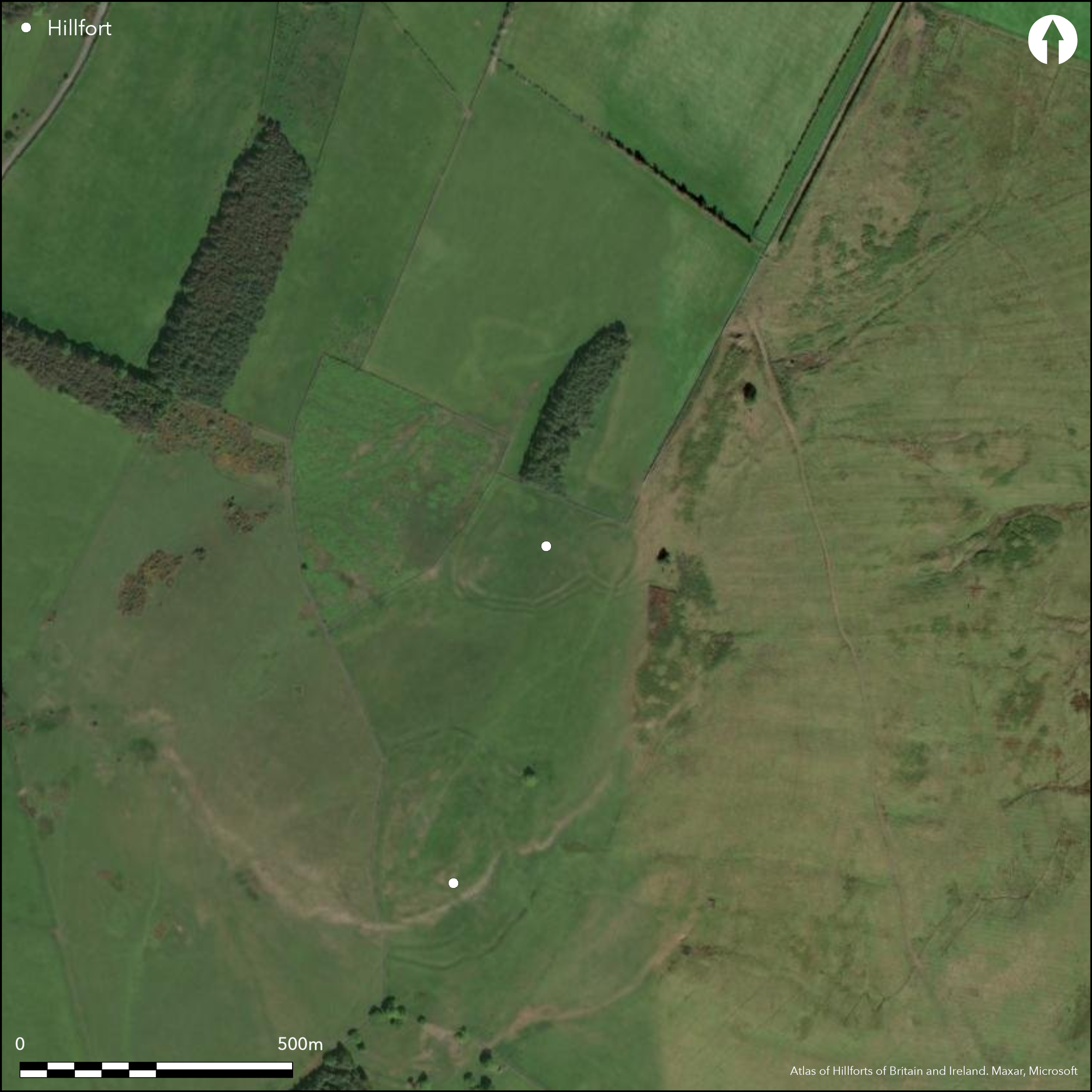
An inusual configuration of earthworks on the N spur of Bonchester Hill, overlooked by the better known fort occupying the summit, includes elements of defence which suggest that it should be considered in part as an element within the overall sequence of fortified settlement on the hill. At its core lies a fortified settlement situated on the crest of the spur, but this has evidently been adapted and modified in a series of stages, which includes the addition of a large rectilinear enclosure on the slope to the NW and the incorporation of both into the line of a linear earthwork that crosses the spur from E to W, the latter almost certainly representing one of the last elements to be constructed. The fortified settlement is oval on plan and measures internally 52m from NNE to SSW by 45m transversely (0.18ha). Its defences are best preserved around the W half of the circuit, where they comprise twin ramparts with a medial ditch about 5m in breadth, but on the S the inner appears to become the outer, forming the counterscarp to the ditch around the rest of the circuit as far as the entrance on the E, and there is no trace of a rampart along the inner lip of the ditch. While in 1949 RCAHMS investigators merely noted the unusual configuration of the ramparts that resulted at the entrance on the NE, it is perhaps more likely that this represents a modification of an original bivallate circuit, in which the inner rampart was extended across the ditch on the S to adopt the outer line on the E; this stratigraphy is partly obscured by the way the ditch of the linear earthwork has also been cut through the outer rampart on the S. At the entrance, like many other bivallate earthworks in Roxburghshire, the ramparts return and unite around the W ditch terminal, and doubtless was originally matched around the E terminal. Apart from a bank traversing from NE to SW, the interior is featureless. On the SW, the ditches of both the linear earthwork and the rectilinear enclosure are punched through the line of the inner rampart, the enclosure probably the remains of a late Iron Age settlement taking in an area of at least 1.2ha, within which there are evidence of both an inner and outer enclosure, a series of scooped courts and yards, and several possible round-houses.
Citizen Science: ✗
Reliability of Data: Confirmed
Reliability of Interpretation: Confirmed
X: -293825 Y: 7440035 (EPSG: 3857)
Longitude: -2.639477909988372 Latitude: 55.400750215198364 (EPSG:4326)
Country: Scotland
Current County or Unitary Authority: Scottish Borders
Historic County: Roxburghshire
Current Parish/Community/Council/Townland: Hobkirk
None
| Extant | ✓ |
| Cropmark | ✗ |
| Likely Destroyed | ✗ |
None
| Woodland | ✗ |
| Commercial Forestry Plantation | ✗ |
| Parkland | ✗ |
| Pasture (Grazing) | ✓ |
| Arable | ✗ |
| Scrub/Bracken | ✗ |
| Bare Outcrop | ✗ |
| Heather/Moorland | ✓ |
| Heath | ✗ |
| Built-up | ✗ |
| Coastal Grassland | ✗ |
| Other | ✗ |
None
| Contour Fort | ✗ |
| Partial Contour Fort | ✗ |
| Promontory Fort | ✗ |
| Hillslope Fort | ✗ |
| Level Terrain Fort | ✓ |
| Marsh Fort | ✗ |
| Multiple Enclosure Fort | ✗ |
| Hilltop | ✗ |
| Coastal Promontory | ✗ |
| Inland Promontory | ✗ |
| Valley Bottom | ✗ |
| Knoll/Hillock/Outcrop | ✗ |
| Ridge | ✗ |
| Cliff/Plateau-edge/Scarp | ✗ |
| Hillslope | ✗ |
| Lowland | ✗ |
| Spur | ✓ |
Dominant Topographic Feature: None
| North | ✗ |
| Northeast | ✗ |
| East | ✗ |
| Southeast | ✗ |
| South | ✗ |
| Southwest | ✗ |
| West | ✗ |
| Northwest | ✗ |
| Level | ✓ |
Altitude: 286.0m
N/A
In the absence of excavation, there are neither stratified artefacts nor radiocarbon dates to provide a chronology for the defences.
Reliability: D - None
| Pre 1200BC | ✗ |
| 1200BC - 800BC | ✗ |
| 800BC - 400BC | ✗ |
| 400BC - AD50 | ✗ |
| AD50 - AD400 | ✗ |
| AD400 - AD 800 | ✗ |
| Post AD800 | ✗ |
| Unknown | ✓ |
| Pre Hillfort: | None |
| Post Hillfort: | Probably overlain by a late Iron Age settlement |
Photographed from the air by CUCAP in 1949, Dennis Harding in 1982, and by RCAHMS Aerial Survey Programme in 1992, 1997 and 2010
| Other (1770): | Annotated 'chester' on Mathew Stobie's A map of Roxburghshire or Tiviotdale (1770) |
| 1st Identified Written Reference (1836): | Noted (NSA, 3, Roxburghshire, 212) |
| Other (1858): | Annotated Camp in Roman Type on the 1st edition OS 25-inch map (Roxburgh 1863, sheet 26.11) |
| Other (1884): | Noted (Geikie 1884, 143-4) |
| Earthwork Survey (1949): | Plan and description (RCAHMS 1956, 152-3, no.278, fig 181; RCAHMS RXD 115/3-4) |
| Other (1961): | Scheduled |
| Other (1965): | Resurveyed at 1:2500 by the OS |
Featureless apart from a later bank traversing from NE to SW
None
| None | ✓ |
| Spring | ✗ |
| Stream | ✗ |
| Pool | ✗ |
| Flush | ✗ |
| Well | ✗ |
| Other | ✗ |
None
| No Known Features | ✓ |
| Round Stone Structures | ✗ |
| Rectangular Stone Structures | ✗ |
| Curvilinear Platforms | ✗ |
| Other Roundhouse Evidence | ✗ |
| Pits | ✗ |
| Quarry Hollows | ✗ |
| Other | ✗ |
None
| No Known Excavation | ✓ |
| Pits | ✗ |
| Postholes | ✗ |
| Roundhouses | ✗ |
| Rectangular Structures | ✗ |
| Roads/Tracks | ✗ |
| Quarry Hollows | ✗ |
| Other | ✗ |
| Nothing Found | ✗ |
None
| No Known Geophysics | ✓ |
| Pits | ✗ |
| Roundhouses | ✗ |
| Rectangular Structures | ✗ |
| Roads/Tracks | ✗ |
| Quarry Hollows | ✗ |
| Other | ✗ |
| Nothing Found | ✗ |
None
| No Known Finds | ✓ |
| Pottery | ✗ |
| Metal | ✗ |
| Metalworking | ✗ |
| Human Bones | ✗ |
| Animal Bones | ✗ |
| Lithics | ✗ |
| Environmental | ✗ |
| Other | ✗ |
NO APPARENT FEATURES
| APs Not Checked | ✗ |
| None | ✓ |
| Roundhouses | ✗ |
| Rectangular Structures | ✗ |
| Pits | ✗ |
| Postholes | ✗ |
| Roads/Tracks | ✗ |
| Other | ✗ |
See main summary
| 1: | None |
| 2: | None |
Guard Chambers: ✗
Chevaux de Frise: ✗
| 1. Passage-way/Corridor (North east): | The ramparts return and unite around the terminals of the ditches |
Twin ramparts and a medial ditch, variously reconfigured and overlain by later settlement earthworks probably dating from the Late Iron Age
| Area 1: | 0.18ha. |
| Total: | 0.18ha. |
Total Footprint Area: Noneha.
None
| ✗ | None |
| ✓ | None |
| NE Quadrant: | 2 |
| SE Quadrant: | 2 |
| SW Quadrant: | 2 |
| NW Quadrant: | 2 |
| Total: | 2 |
| Partial Univallate | ✗ |
| Univallate | ✗ |
| Partial Bivallate | ✗ |
| Bivallate | ✓ |
| Partial Multivallate | ✗ |
| Multivallate | ✗ |
| Unknown | ✗ |
| Partial Univallate | ✗ |
| Univallate | ✗ |
| Partial Bivallate | ✗ |
| Bivallate | ✗ |
| Partial Multivallate | ✗ |
| Multivallate | ✗ |
None
| None | ✗ |
| Earthen Bank | ✓ |
| Stone Wall | ✗ |
| Rubble | ✗ |
| Wall-walk | ✗ |
| Evidence of Timber | ✗ |
| Vitrification | ✗ |
| Other Burning | ✗ |
| Palisade | ✗ |
| Counter Scarp Bank | ✗ |
| Berm | ✗ |
| Unfinished | ✗ |
| Other | ✗ |
None
| None | ✗ |
| Earthen Bank | ✗ |
| Stone Wall | ✗ |
| Murus Duplex | ✗ |
| Timber-framed | ✗ |
| Timber-laced | ✗ |
| Vitrification | ✗ |
| Other Burning | ✗ |
| Palisade | ✗ |
| Counter Scarp Bank | ✗ |
| Berm | ✗ |
| Unfinished | ✗ |
| No Known Excavation | ✓ |
| Other | ✗ |
| ✗ | None |
| ✓ | None |
Number of Ditches: 1
| ✗ | None |
Geikie, J (1884) «List of hill forts, intrenched camps, etc. in Roxburghshire on the Scotch side of the Cheviots». Hist Berwickshire Natur Club 10 (1882-4) 139-44
NSA (1834-1845) The new statistical account of Scotland by the ministers of the respective parishes under the superintendence of a committee of the society for the benefit of the sons and daughters of the clergy.
RCAHMS (1956) The Royal Commission on the Ancient and Historical Monuments of Scotland. An inventory of the ancient and historical monuments of Roxburghshire: with the fourteenth report of the Commission, 2v. HMSO: Edinburgh
Atlas of Hillforts:
Wikidata:
This work is licensed under CC BY-SA 4.0![]()
![]()
![]() and should be cited as:
and should be cited as:
Lock, Gary and Ralston, Ian. 2024. Atlas of Hillforts of Britain and Ireland. Available at: https://hillforts.arch.ox.ac.uk
Document Version 1.1