Satellite Imagery
Satellite Imagery
HER: Scottish Borders 55668 (None)
NMR: NT 53 SE 57 (55668)
SM: 2107
NGR: NT 5545 3280
X: 355450 Y: 632800 (OSGB36)
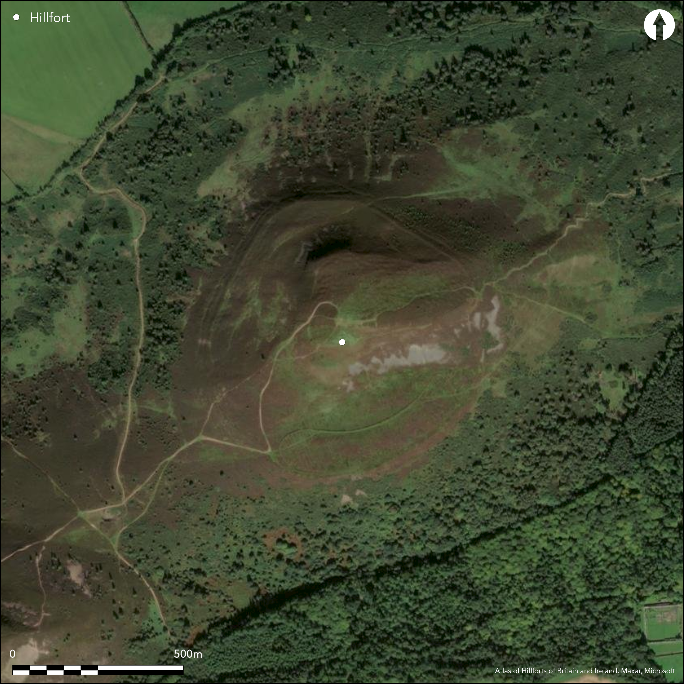
Eildon Hill North, the easternmost of the three summits of the Eildon Hills has long been known as the site of one of the largest fortifications in Scotland. At least two circuits of defences can be distinguished, the inner enclosing the plateau that slopes down E from the summit of the hill, and the outer contouring along a shoulder lower down the slope, but climbing up on the E to ride over the E end of the plateau. The outer, comprising three ramparts for much of the circuit, though in places they are reduced to little more than terraces and only two can be detected, encloses 15.5ha, while the inner enclosing the plateau, its perimeter little more than an intermittent terrace about 2.4m wide, takes in 3.2ha. No trace of a possible third circuit identified by RCAHMS investigators beneath the house platforms that pack the upper plateau was located when two evaluation trenches were excavated across its line in 1986 (Owen 1992). Five gaps can be seen in the outer belt, of which those on the E, ESE, SW, and WSW are probably original entrances, whereas that on the NNE is pierced obliquely by an engineered trackway and may be relatively recent. The chronology and sequence between the two schemes , however, is uncertain. An evaluation of the inner rampart of the outer belt in 1986 (Owen 1992) at the entrance on the SW uncovered a Late Bronze Age hearth beneath it, but was unable to date the rampart itself. Furthermore the ramparts below it were not excavated and their relationship to the inner rests on the assumption that the concentric belt recorded by survey is a single contemporary entity. Doubts about the wisdom of this assumption arise on the E, where the belt of ramparts climbs up to the E end of the upper plateau. Aerial photographs of this intersection taken under snow in 2010 suggest that whereas the inner rampart climbs straight over the top of the plateau perimeter, the outer ones divert around its foot. The relationship is on the one hand clear-cut, and on the other ambiguous, but at the very least implies that the inner rampart in its present form post-dates the plateau fortification, blocking an earlier entrance in the latter's E end; more tentatively, it might be contended that the outer belt of defences incorporates two separate elements with a much wider chronology. If this is the case it might go some way to explaining the very wide range of dates recovered from the excavation on the SW in 1986 of three of the numerous platforms that are visible along the lower slopes below the plateau. Two returned Late Bronze Age radiocarbon dates, while a second occupation on one of them, and on a third adjacent, were firmly dated to the Roman Iron Age. The artefact assemblages recovered in 1986 broadly reflect this same pattern, earlier items including a bronze chisel or punch and evidence of bronze metallurgy, the later two fibula, a glass bead, glass armlets iron metallurgy and Roman pottery.
Citizen Science: ✗
Reliability of Data: Confirmed
Reliability of Interpretation: Confirmed
X: -301491 Y: 7476601 (EPSG: 3857)
Longitude: -2.708340818409647 Latitude: 55.586827280063304 (EPSG:4326)
Country: Scotland
Current County or Unitary Authority: Scottish Borders
Historic County: Roxburghshire
Current Parish/Community/Council/Townland: Melrose
None
| Extant | ✓ |
| Cropmark | ✗ |
| Likely Destroyed | ✗ |
None
| Woodland | ✗ |
| Commercial Forestry Plantation | ✗ |
| Parkland | ✗ |
| Pasture (Grazing) | ✓ |
| Arable | ✗ |
| Scrub/Bracken | ✗ |
| Bare Outcrop | ✗ |
| Heather/Moorland | ✓ |
| Heath | ✗ |
| Built-up | ✗ |
| Coastal Grassland | ✗ |
| Other | ✗ |
None
| Contour Fort | ✓ |
| Partial Contour Fort | ✗ |
| Promontory Fort | ✗ |
| Hillslope Fort | ✗ |
| Level Terrain Fort | ✗ |
| Marsh Fort | ✗ |
| Multiple Enclosure Fort | ✓ |
| Hilltop | ✓ |
| Coastal Promontory | ✗ |
| Inland Promontory | ✗ |
| Valley Bottom | ✗ |
| Knoll/Hillock/Outcrop | ✗ |
| Ridge | ✗ |
| Cliff/Plateau-edge/Scarp | ✗ |
| Hillslope | ✗ |
| Lowland | ✗ |
| Spur | ✗ |
Dominant Topographic Feature: The three Eildon Hills are a distinctive landmark visible from all over the lower Tweed basin.
| North | ✗ |
| Northeast | ✗ |
| East | ✗ |
| Southeast | ✗ |
| South | ✗ |
| Southwest | ✗ |
| West | ✗ |
| Northwest | ✗ |
| Level | ✓ |
Altitude: 404.0m
N/A
While dating evidence has been retrieved by excavations in 1986, it is not entirely clear how these relate to the hillfort. Thus while a late Bronze Age hearth was located beneath the main belt of ramparts, and at least two of the house-platforms date from this period, it is not known whether the main rampart system is Late Bronze Age. Likewise two of the house platforms were occupied in the Roman Iron Age, but it is not known whether any of the defences are of this date. Horn (Forthcoming) nonetheless suggests on the basis of these dates First hillfort use starting 1010-740 cal BC, LBA end 825-720, RIA start AD60-225, RIA end AD200-385.
Reliability: A - High
| Pre 1200BC | ✗ |
| 1200BC - 800BC | ✓ |
| 800BC - 400BC | ✗ |
| 400BC - AD50 | ✗ |
| AD50 - AD400 | ✓ |
| AD400 - AD 800 | ✗ |
| Post AD800 | ✗ |
| Unknown | ✗ |
| Pre Hillfort: | None |
| Post Hillfort: | None |
| Artefactual: | Roman pottery, fibula, glass bead and glass armlets relate to an Roman Iron Age occupation |
| C14: | Thirteen radiocarbon dates split between the Late Bronze Age and the Roman Iron Age |
RCAHMS not only holds the archive for the excavations in 1986, but an extensive collection of aerial photographs taken by M Brooks of Historic Scotland in 1980, Dennis Harding in 1978, John Dent in 1990 and 1991, CUCAP in 1945, 1948, 1955, 1969 and 1972, and the RCAHMS Aerial Survey Programme in 1976, 1980, 1984, 1985, 1987 1992, 2006, 2008, 2009, 2010 and 2013
| 1st Identified Written Reference (1743): | Description by Adam Milne (1743) |
| 1st Identified Map Depiction (1770): | Annotated Camp on Matthew Stobie's A Map of Roxburghshire or Tiviotdale (1770) |
| Other (1858): | Annotated Camp on the 1st edition OS 25-inch map (Roxburgh 1863, sheet 8.5) |
| Earthwork Survey (1893): | Plan based on 25-inch map and description by David Christison (1894, 111-19) |
| Excavation (1894): | Excavations on three house platforms by James Curle (Christison 1894, 119) |
| Earthwork Survey (1950): | Plan and description (RCAHMS 1956, 306-10, no.597, fig 417; RCAHMS RXD 148/1-8) |
| Excavation (1953): | Trial excavation 1952-3 of the Roman signal station on the summit (Steer and Feachem 1952) |
| Other (1961): | Scheduled |
| Other (1961): | Visited by the OS |
| Other (1976): | Visited by the Hill-fort Study Group |
| Excavation (1986): | Directed by Olwyn Owen (1992) |
The whole of the interior of the upper plateau is packed with house platforms, while numerous others can be seen along the lower slopes above the main belt of defences. Including some allowance for those ploughe out on the S side of the entrance they are numbered in hundreds.
None
| None | ✓ |
| Spring | ✗ |
| Stream | ✗ |
| Pool | ✗ |
| Flush | ✗ |
| Well | ✗ |
| Other | ✗ |
None
| No Known Features | ✓ |
| Round Stone Structures | ✗ |
| Rectangular Stone Structures | ✗ |
| Curvilinear Platforms | ✗ |
| Other Roundhouse Evidence | ✗ |
| Pits | ✗ |
| Quarry Hollows | ✗ |
| Other | ✗ |
None
| No Known Excavation | ✗ |
| Pits | ✓ |
| Postholes | ✓ |
| Roundhouses | ✓ |
| Rectangular Structures | ✗ |
| Roads/Tracks | ✗ |
| Quarry Hollows | ✗ |
| Other | ✗ |
| Nothing Found | ✗ |
None
| No Known Geophysics | ✓ |
| Pits | ✗ |
| Roundhouses | ✗ |
| Rectangular Structures | ✗ |
| Roads/Tracks | ✗ |
| Quarry Hollows | ✗ |
| Other | ✗ |
| Nothing Found | ✗ |
Assemblage from the 1986 excavations includes coarse stone tools (hammerstones, whetstones and quern fragments), flint and chert tools (including arrowheads), three fragments of jet armlet, a glass bead and three fragments of armlets, a bronze chisel or punch, two Roman brooches, sherds of coarse pottery, metalworking debris and several iron nails (Owen 1992, 40-49). Previous stray finds include a denarius of Hadrian, a whetstone, fragments of pottery (including a possible Roman sherd), while coarse pottery and a dupondius of Trajan were recovered from the Roman signal station.
| No Known Finds | ✗ |
| Pottery | ✓ |
| Metal | ✓ |
| Metalworking | ✓ |
| Human Bones | ✗ |
| Animal Bones | ✗ |
| Lithics | ✓ |
| Environmental | ✗ |
| Other | ✓ |
Dimpled with house-platforms
| APs Not Checked | ✗ |
| None | ✗ |
| Roundhouses | ✓ |
| Rectangular Structures | ✗ |
| Pits | ✗ |
| Postholes | ✗ |
| Roads/Tracks | ✗ |
| Other | ✗ |
See main summary
| 5: | Fifth gap on the NNE was discounted by RCAHMS investigators in 1950 |
| 2: | A fifth blocked entrance belongs to the earlier inner enclosure |
Guard Chambers: ✗
Chevaux de Frise: ✗
| 1. Oblique (East): | Outer belt; modern path approaches obliquely through the defences exposing the visitor's right side |
| 2. Simple Gap (South east): | Outer belt |
| 3. Oblique (South west): | Outer belt, forming a shallow re-entrant; modern track climbe obliquely into the gap exposing the visitor's left side |
| 4. Simple Gap (West): | Outer belt, forming a shallow re-entrant |
| 5. Blocked (East): | Immediately N of 1, traces of an earlier entrance can be seen in the E end of the earlier enclosure, but blocked by the ramparts of the outer enclosure |
Two or three concentric ramparts encircle the whole hill, while the upper plateau is separately enclosed by a single rampart. The existence of a third inner enclosure is uncertain, appearing fleetingly on aerial photograps but not located in trial excavation trenches dug in 1986 (Owen 1992, 32-3)
| Area 1: | 3.2ha. |
| Area 2: | 15.5ha. |
| Total: | 15.5ha. |
Total Footprint Area: 18.6ha.
None
| ✓ | Clear sequence between the plateau enclosure and the outer defences |
| ✓ | None |
| NE Quadrant: | 4 |
| SE Quadrant: | 3 |
| SW Quadrant: | 4 |
| NW Quadrant: | 4 |
| Total: | 4 |
| Partial Univallate | ✗ |
| Univallate | ✗ |
| Partial Bivallate | ✗ |
| Bivallate | ✗ |
| Partial Multivallate | ✗ |
| Multivallate | ✓ |
| Unknown | ✗ |
| Partial Univallate | ✗ |
| Univallate | ✓ |
| Partial Bivallate | ✗ |
| Bivallate | ✗ |
| Partial Multivallate | ✗ |
| Multivallate | ✗ |
None
| None | ✗ |
| Earthen Bank | ✓ |
| Stone Wall | ✗ |
| Rubble | ✗ |
| Wall-walk | ✗ |
| Evidence of Timber | ✗ |
| Vitrification | ✗ |
| Other Burning | ✗ |
| Palisade | ✗ |
| Counter Scarp Bank | ✗ |
| Berm | ✗ |
| Unfinished | ✗ |
| Other | ✗ |
None
| None | ✗ |
| Earthen Bank | ✓ |
| Stone Wall | ✗ |
| Murus Duplex | ✗ |
| Timber-framed | ✗ |
| Timber-laced | ✗ |
| Vitrification | ✗ |
| Other Burning | ✗ |
| Palisade | ✗ |
| Counter Scarp Bank | ✗ |
| Berm | ✗ |
| Unfinished | ✗ |
| No Known Excavation | ✗ |
| Other | ✗ |
| ✗ | None |
| ✓ | In the creation of the ramparts there appears to be a certain amount of shallow linear quarrying |
Number of Ditches: 2
| ✗ | None |
Christison, D (1894) 'The prehistoric fortresses of Treceiri, and Eildon, Roxburgh. Proc Soc Antiq Scot 28 (1893-4), 101-19
Horn, J. Forthcoming. The dating of hillforts in Britain and Ireland. Unpublished PhD thesis, University of Edinburgh.
Milne, A (1743) Description of the parish of Melrose; in answer to Mr. Maitland's queries, sent to each parish of the Kingdom
Owen, O A 1992 'Eildon Hill North'. 21-72 in Rideout, J S, Owen, O A and Halpin, E (1992) Hillforts of southern Scotland. AOC (Scotland) Ltd and Historic Scotland: Edinburgh
RCAHMS (1956) The Royal Commission on the Ancient and Historical Monuments of Scotland. An inventory of the ancient and historical monuments of Roxburghshire: with the fourteenth report of the Commission, 2v. HMSO: Edinburgh
Steer, K A S and Feachem, R W (1952) 'A Roman signal-station on Eildon Hill North, Roxburghshire'. Proc Soc Antiq Scot 86 (1951-2), 202-5
Atlas of Hillforts:
Wikidata:
This work is licensed under CC BY-SA 4.0![]()
![]()
![]() and should be cited as:
and should be cited as:
Lock, Gary and Ralston, Ian. 2024. Atlas of Hillforts of Britain and Ireland. Available at: https://hillforts.arch.ox.ac.uk
Document Version 1.1