Satellite Imagery
Satellite Imagery
HER: Scottish Borders 56807 (None)
NMR: NT 60 NE 2 (56807)
SM: 2152
NGR: NT 6727 0945
X: 367270 Y: 609450 (OSGB36)
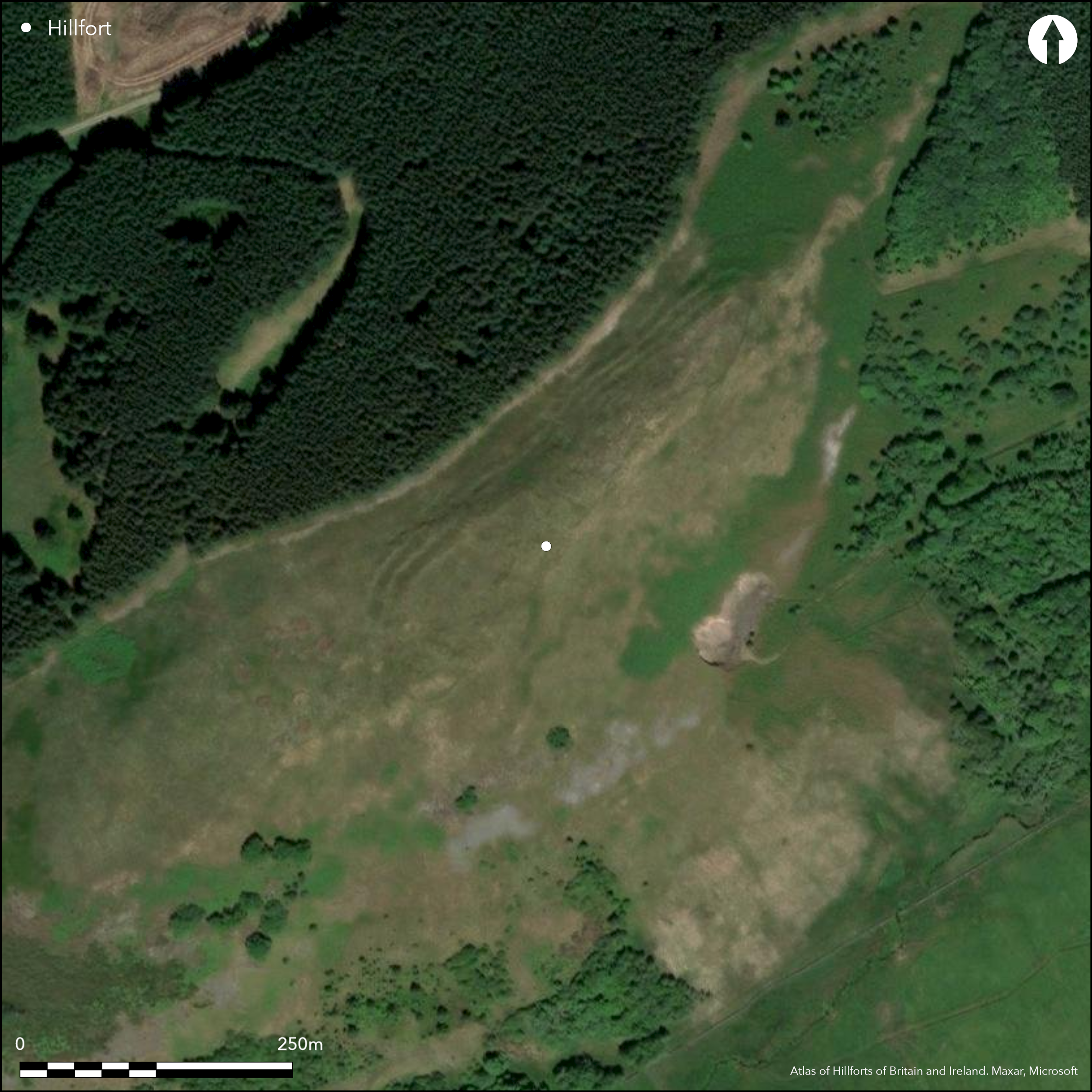
A complex fort is situated on the elongated summit of the hill above Shaw Craigs, from which the ground falls away steeply on all sides. The defences exhibit three phases of construction, the most prominent of which belong to the second, comprising a belt of three ramparts extending along its NW flank and around the NE and SW ends to enclose an area measuring 267m from NE to SW by 52m transversely (1ha). At either end the inner rampart returns for a short distance along the lip of the escarpment forming the SE flank of the hill, but this side is otherwise left undefended. Entrances pierce the defences on the NE and SW, on the NE apparently accompanied by an outlying segment of bank and ditch forming a traverse across the NE end of the hill; a linear earthwork springs from close to its W end to drop down the hill to the N. Apart from several shallow scoops observed in the central sector by the RCAHMS investigators in 1947, and quarrying to the rear of the inner rampart on the NE, the main features visible within the interior are elements of earlier and later enclosures, the former comprising a heavily reduced rampart cutting across the NE end, and the latter a rectilinear enclosure overlying the SW end. Little more than this short length of the probably earlier rampart, which includes an entrance on the NE, is visible, but if it follows the line of the later defences it would have enclosed an area of about 0.87ha. The rectilinear enclosure has previously been considered to be a fort in its own right, measuring 85m from NE to SW by 49m transversely (0.38ha) within a heavily ruined wall over 3.5m in thickness, and also accompanied on the NE and W by an outer wall, but it seems likely that it is one of a number of rectilinear settlements with robust perimeters that can be found in the district, many of them known only as cropmarks. The interior of the rectilinear enclosure is featureless and its entrance opens into the SW entrance of the earlier fort.
Citizen Science: ✗
Reliability of Data: Confirmed
Reliability of Interpretation: Confirmed
X: -280310 Y: 7435569 (EPSG: 3857)
Longitude: -2.5180659559479217 Latitude: 55.37796140377598 (EPSG:4326)
Country: Scotland
Current County or Unitary Authority: Scottish Borders
Historic County: Roxburghshire
Current Parish/Community/Council/Townland: Jedburgh
None
| Extant | ✓ |
| Cropmark | ✗ |
| Likely Destroyed | ✗ |
Clearing in coniferous woodland
| Woodland | ✗ |
| Commercial Forestry Plantation | ✓ |
| Parkland | ✗ |
| Pasture (Grazing) | ✗ |
| Arable | ✗ |
| Scrub/Bracken | ✗ |
| Bare Outcrop | ✗ |
| Heather/Moorland | ✓ |
| Heath | ✗ |
| Built-up | ✗ |
| Coastal Grassland | ✗ |
| Other | ✗ |
None
| Contour Fort | ✓ |
| Partial Contour Fort | ✗ |
| Promontory Fort | ✗ |
| Hillslope Fort | ✗ |
| Level Terrain Fort | ✗ |
| Marsh Fort | ✗ |
| Multiple Enclosure Fort | ✗ |
| Hilltop | ✓ |
| Coastal Promontory | ✗ |
| Inland Promontory | ✗ |
| Valley Bottom | ✗ |
| Knoll/Hillock/Outcrop | ✗ |
| Ridge | ✗ |
| Cliff/Plateau-edge/Scarp | ✗ |
| Hillslope | ✗ |
| Lowland | ✗ |
| Spur | ✗ |
Dominant Topographic Feature: None
| North | ✗ |
| Northeast | ✗ |
| East | ✗ |
| Southeast | ✗ |
| South | ✗ |
| Southwest | ✗ |
| West | ✗ |
| Northwest | ✗ |
| Level | ✓ |
Altitude: 300.0m
N/A
In the absence of excavation, there are neither stratified artefacts nor radiocarbon dates to provide a chronology for the defences.
Reliability: D - None
| Pre 1200BC | ✗ |
| 1200BC - 800BC | ✗ |
| 800BC - 400BC | ✗ |
| 400BC - AD50 | ✗ |
| AD50 - AD400 | ✗ |
| AD400 - AD 800 | ✗ |
| Post AD800 | ✗ |
| Unknown | ✓ |
| Pre Hillfort: | None |
| Post Hillfort: | Complex sequence in which the final phase is arguably a late Iron Age rectilinear settlement |
None
| 1st Identified Written Reference (1947): | Plan and description (RCAHMS 1956, 229-31, no.459, fig 289; RCAHMS RXD 137/1-5) |
| 1st Identified Map Depiction (1960): | Visited by the OS |
| Other (1961): | Scheduled |
| Other (1976): | Revised at 1:10,000 by the OS |
| Other (1991): | Visited by RCAHMS |
Apart from the final phase of enclosure, which is rectilinear in shape and overlies the earlier defences, RCAHMS investigators noted several hollows that they believed were possibly house platforms, but none is shown on the plan. There are traces of internal quarrying to the rear of the inner rampart at the NE end
None
| None | ✓ |
| Spring | ✗ |
| Stream | ✗ |
| Pool | ✗ |
| Flush | ✗ |
| Well | ✗ |
| Other | ✗ |
None
| No Known Features | ✗ |
| Round Stone Structures | ✗ |
| Rectangular Stone Structures | ✗ |
| Curvilinear Platforms | ✗ |
| Other Roundhouse Evidence | ✗ |
| Pits | ✗ |
| Quarry Hollows | ✓ |
| Other | ✗ |
None
| No Known Excavation | ✓ |
| Pits | ✗ |
| Postholes | ✗ |
| Roundhouses | ✗ |
| Rectangular Structures | ✗ |
| Roads/Tracks | ✗ |
| Quarry Hollows | ✗ |
| Other | ✗ |
| Nothing Found | ✗ |
None
| No Known Geophysics | ✓ |
| Pits | ✗ |
| Roundhouses | ✗ |
| Rectangular Structures | ✗ |
| Roads/Tracks | ✗ |
| Quarry Hollows | ✗ |
| Other | ✗ |
| Nothing Found | ✗ |
None
| No Known Finds | ✓ |
| Pottery | ✗ |
| Metal | ✗ |
| Metalworking | ✗ |
| Human Bones | ✗ |
| Animal Bones | ✗ |
| Lithics | ✗ |
| Environmental | ✗ |
| Other | ✗ |
NO APPARENT FEATURES
| APs Not Checked | ✗ |
| None | ✓ |
| Roundhouses | ✗ |
| Rectangular Structures | ✗ |
| Pits | ✗ |
| Postholes | ✗ |
| Roads/Tracks | ✗ |
| Other | ✗ |
See main summary
| 2: | None |
| 2: | Entrances at either end of the main fort |
Guard Chambers: ✗
Chevaux de Frise: ✗
| 1. Simple Gap (North east): | Through the main belt of defences |
| 1. Simple Gap (North east): | Through putative phase 1 rampart |
| 2. Simple Gap (South west): | Staggered terminals to either side of the gap in the medial rampart of the main belt of defences; gives access to the entrance to the rectilinear inner enclosure |
Triple ramparts everywhere except the SE flank, but possibly succeeding a univallate defence. A rectilinear enclosure was superimposed subsequently on the SW end of the fort
| Area 1: | 0.87ha. |
| Area 2: | 1.0ha. |
| Area 3: | 0.38ha. |
| Total: | 1.0ha. |
Total Footprint Area: 1.9ha.
None
| ✓ | None |
| ✗ | None |
| NE Quadrant: | 4 |
| SE Quadrant: | 0 |
| SW Quadrant: | 3 |
| NW Quadrant: | 3 |
| Total: | 4 |
| Partial Univallate | ✗ |
| Univallate | ✗ |
| Partial Bivallate | ✗ |
| Bivallate | ✗ |
| Partial Multivallate | ✓ |
| Multivallate | ✗ |
| Unknown | ✗ |
| Partial Univallate | ✓ |
| Univallate | ✗ |
| Partial Bivallate | ✗ |
| Bivallate | ✗ |
| Partial Multivallate | ✗ |
| Multivallate | ✗ |
None
| None | ✗ |
| Earthen Bank | ✓ |
| Stone Wall | ✗ |
| Rubble | ✓ |
| Wall-walk | ✗ |
| Evidence of Timber | ✗ |
| Vitrification | ✗ |
| Other Burning | ✗ |
| Palisade | ✗ |
| Counter Scarp Bank | ✗ |
| Berm | ✗ |
| Unfinished | ✗ |
| Other | ✗ |
None
| None | ✗ |
| Earthen Bank | ✗ |
| Stone Wall | ✗ |
| Murus Duplex | ✗ |
| Timber-framed | ✗ |
| Timber-laced | ✗ |
| Vitrification | ✗ |
| Other Burning | ✗ |
| Palisade | ✗ |
| Counter Scarp Bank | ✗ |
| Berm | ✗ |
| Unfinished | ✗ |
| No Known Excavation | ✓ |
| Other | ✗ |
| ✗ | None |
| ✗ | While no ditches appear in the description, the plan and profiles suggest that a certain amount of linear quarrying between the ramparts was probably involved in their construction |
Number of Ditches: None
| ✗ | None |
RCAHMS (1956) The Royal Commission on the Ancient and Historical Monuments of Scotland. An inventory of the ancient and historical monuments of Roxburghshire: with the fourteenth report of the Commission, 2v. HMSO: Edinburgh
Atlas of Hillforts:
Wikidata:
This work is licensed under CC BY-SA 4.0![]()
![]()
![]() and should be cited as:
and should be cited as:
Lock, Gary and Ralston, Ian. 2024. Atlas of Hillforts of Britain and Ireland. Available at: https://hillforts.arch.ox.ac.uk
Document Version 1.1