LiDAR 1m DTM Hillshade
Satellite Imagery
LiDAR 1m DTM Hillshade
Satellite Imagery
Scroll left/right to view further images.
HER: Scottish Borders 56826 (None)
NMR: NT 60 NW 2 (56826)
SM: 2211
NGR: NT 6350 0938
X: 363500 Y: 609380 (OSGB36)
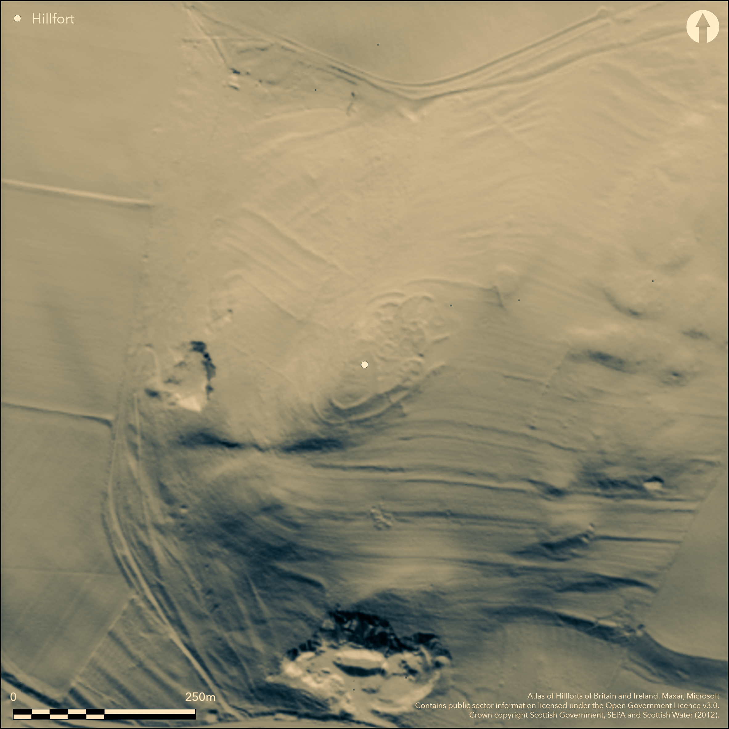
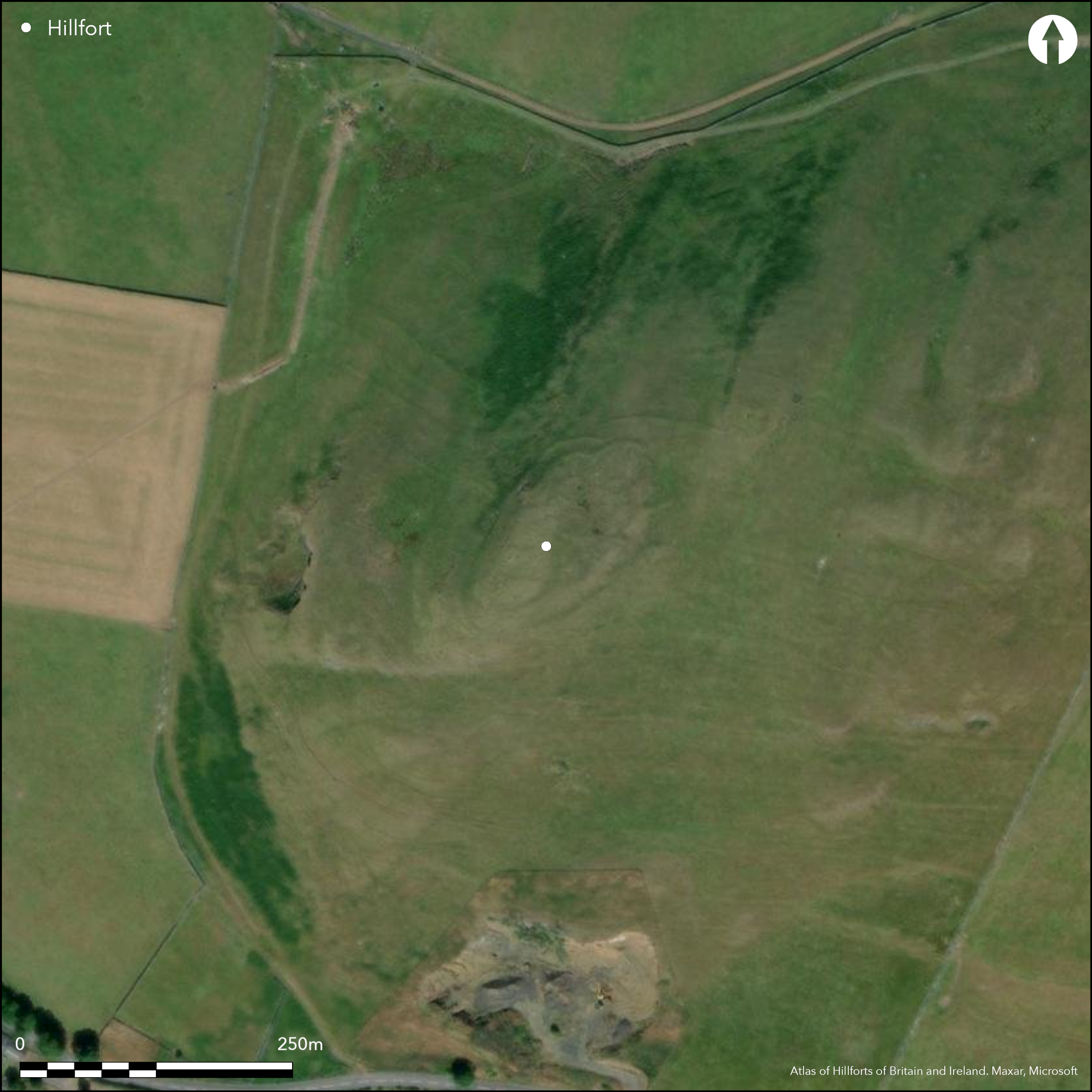
This fort occupies the western of the two summits that make up the top of Southdean Law. Pear-shaped on plan, it measures about 88m from NE to SW by up to 46m transversely (0.32ha) within two ramparts up to 12m apart. Both ramparts are reduced to scarps, the outer studded with intermittent outer facing stones on the SW quarter, and have been largely obliterated on the NE by an overlying late Iron Age settlement comprising up to twelve stone-founded round-houses and platforms with a series of scooped courts and enclosures. Probably reusing the entrance into the fort on the E, the SW side of this settlement is bounded by a bank that cuts across the interior of the fort from NE to SW, and may even be the remains of an independent enclosure taking in the summit.
Citizen Science: ✗
Reliability of Data: Confirmed
Reliability of Interpretation: Confirmed
X: -286931 Y: 7435394 (EPSG: 3857)
Longitude: -2.577549143957618 Latitude: 55.37706589599776 (EPSG:4326)
Country: Scotland
Current County or Unitary Authority: Scottish Borders
Historic County: Roxburghshire
Current Parish/Community/Council/Townland: Southdean
None
| Extant | ✓ |
| Cropmark | ✗ |
| Likely Destroyed | ✗ |
None
| Woodland | ✗ |
| Commercial Forestry Plantation | ✗ |
| Parkland | ✗ |
| Pasture (Grazing) | ✓ |
| Arable | ✗ |
| Scrub/Bracken | ✗ |
| Bare Outcrop | ✗ |
| Heather/Moorland | ✓ |
| Heath | ✗ |
| Built-up | ✗ |
| Coastal Grassland | ✗ |
| Other | ✗ |
None
| Contour Fort | ✓ |
| Partial Contour Fort | ✗ |
| Promontory Fort | ✗ |
| Hillslope Fort | ✗ |
| Level Terrain Fort | ✗ |
| Marsh Fort | ✗ |
| Multiple Enclosure Fort | ✗ |
| Hilltop | ✓ |
| Coastal Promontory | ✗ |
| Inland Promontory | ✗ |
| Valley Bottom | ✗ |
| Knoll/Hillock/Outcrop | ✗ |
| Ridge | ✗ |
| Cliff/Plateau-edge/Scarp | ✗ |
| Hillslope | ✗ |
| Lowland | ✗ |
| Spur | ✗ |
Dominant Topographic Feature: None
| North | ✗ |
| Northeast | ✗ |
| East | ✗ |
| Southeast | ✗ |
| South | ✗ |
| Southwest | ✗ |
| West | ✗ |
| Northwest | ✗ |
| Level | ✓ |
Altitude: 290.0m
N/A
In the absence of excavation, there are neither stratified artefacts nor radiocarbon dates to provide a chronology for the defences.
Reliability: D - None
| Pre 1200BC | ✗ |
| 1200BC - 800BC | ✗ |
| 800BC - 400BC | ✗ |
| 400BC - AD50 | ✗ |
| AD50 - AD400 | ✗ |
| AD400 - AD 800 | ✗ |
| Post AD800 | ✗ |
| Unknown | ✓ |
| Pre Hillfort: | None |
| Post Hillfort: | Overlain by Late Iron Age settlement |
In the most recent fieldwork here by RCAHMS, Piers Dixon suggests that the bank delimiting the SW side of the later settlement was a primary rampart, to which an annexe had been added before both were encompassed by the outer rampart. While the bank may well be part of the defensive sequence rather than the later settlement, Dixon's sequence is unnecessarily complicated for the available evidence, though this is not to say that the bank in question is not either primary, or indeed a contraction of the interior at some point prior to the construction of the late Iron Age settlement. Aerial photographs were taken of the fort in 1992, and more recently kite photographs by Hamish Fenton.
| 1st Identified Map Depiction (1859): | Annotated Fort on the 1st edition OS 25-inch map (Roxburgh 1863, sheet 34.1) |
| Other (1884): | Noted (Geikie 1884, 143) |
| Earthwork Survey (1947): | Plan and description (RCAHMS 1956, 424-6, no.942, fig 564; RCAHMS RXD 191/1-2; Feachem 1963, 153) |
| Other (1962): | Scheduled |
| Other (1967): | Resurveyed at 1:2500 by the OS |
| Other (1976): | Visited by the OS |
| Other (1992): | Description by RCAHMS |
Featureless apart from the overlying late Iron Age settlement
None
| None | ✓ |
| Spring | ✗ |
| Stream | ✗ |
| Pool | ✗ |
| Flush | ✗ |
| Well | ✗ |
| Other | ✗ |
There is no reason to believe that any of these structures pre-date the late Iron Age settlement
| No Known Features | ✗ |
| Round Stone Structures | ✓ |
| Rectangular Stone Structures | ✗ |
| Curvilinear Platforms | ✓ |
| Other Roundhouse Evidence | ✗ |
| Pits | ✗ |
| Quarry Hollows | ✗ |
| Other | ✗ |
None
| No Known Excavation | ✓ |
| Pits | ✗ |
| Postholes | ✗ |
| Roundhouses | ✗ |
| Rectangular Structures | ✗ |
| Roads/Tracks | ✗ |
| Quarry Hollows | ✗ |
| Other | ✗ |
| Nothing Found | ✗ |
None
| No Known Geophysics | ✓ |
| Pits | ✗ |
| Roundhouses | ✗ |
| Rectangular Structures | ✗ |
| Roads/Tracks | ✗ |
| Quarry Hollows | ✗ |
| Other | ✗ |
| Nothing Found | ✗ |
None
| No Known Finds | ✓ |
| Pottery | ✗ |
| Metal | ✗ |
| Metalworking | ✗ |
| Human Bones | ✗ |
| Animal Bones | ✗ |
| Lithics | ✗ |
| Environmental | ✗ |
| Other | ✗ |
Round-houses belong to the late Iron Age settlement
| APs Not Checked | ✗ |
| None | ✗ |
| Roundhouses | ✓ |
| Rectangular Structures | ✗ |
| Pits | ✗ |
| Postholes | ✗ |
| Roads/Tracks | ✗ |
| Other | ✗ |
See main summary
| 1: | The NE sector is virtually obliterated by the late Iron Age settlement |
| 2: | None |
Guard Chambers: ✗
Chevaux de Frise: ✗
| 1. Simple Gap (East): | None |
Twin ramparts set about 12m apart
| Area 1: | 0.32ha. |
| Total: | 0.32ha. |
Total Footprint Area: 0.7ha.
None
| ✗ | None |
| ✓ | Enough remains to be confident that this was a complete circuit |
| NE Quadrant: | 2 |
| SE Quadrant: | 2 |
| SW Quadrant: | 2 |
| NW Quadrant: | 2 |
| Total: | 2 |
| Partial Univallate | ✗ |
| Univallate | ✗ |
| Partial Bivallate | ✗ |
| Bivallate | ✓ |
| Partial Multivallate | ✗ |
| Multivallate | ✗ |
| Unknown | ✗ |
| Partial Univallate | ✗ |
| Univallate | ✗ |
| Partial Bivallate | ✗ |
| Bivallate | ✗ |
| Partial Multivallate | ✗ |
| Multivallate | ✗ |
None
| None | ✗ |
| Earthen Bank | ✗ |
| Stone Wall | ✓ |
| Rubble | ✓ |
| Wall-walk | ✗ |
| Evidence of Timber | ✗ |
| Vitrification | ✗ |
| Other Burning | ✗ |
| Palisade | ✗ |
| Counter Scarp Bank | ✗ |
| Berm | ✗ |
| Unfinished | ✗ |
| Other | ✗ |
None
| None | ✗ |
| Earthen Bank | ✗ |
| Stone Wall | ✗ |
| Murus Duplex | ✗ |
| Timber-framed | ✗ |
| Timber-laced | ✗ |
| Vitrification | ✗ |
| Other Burning | ✗ |
| Palisade | ✗ |
| Counter Scarp Bank | ✗ |
| Berm | ✗ |
| Unfinished | ✗ |
| No Known Excavation | ✓ |
| Other | ✗ |
| ✗ | None |
| ✗ | None |
Number of Ditches: None
| ✗ | None |
Feachem, R W (1963) A guide to prehistoric Scotland. Batsford: London
Geikie, J (1884) «List of hill forts, intrenched camps, etc. in Roxburghshire on the Scotch side of the Cheviots». Hist Berwickshire Natur Club 10 (1882-4) 139-44
RCAHMS (1956) The Royal Commission on the Ancient and Historical Monuments of Scotland. An inventory of the ancient and historical monuments of Roxburghshire: with the fourteenth report of the Commission, 2v. HMSO: Edinburgh
Atlas of Hillforts:
Wikidata:
This work is licensed under CC BY-SA 4.0![]()
![]()
![]() and should be cited as:
and should be cited as:
Lock, Gary and Ralston, Ian. 2024. Atlas of Hillforts of Britain and Ireland. Available at: https://hillforts.arch.ox.ac.uk
Document Version 1.1