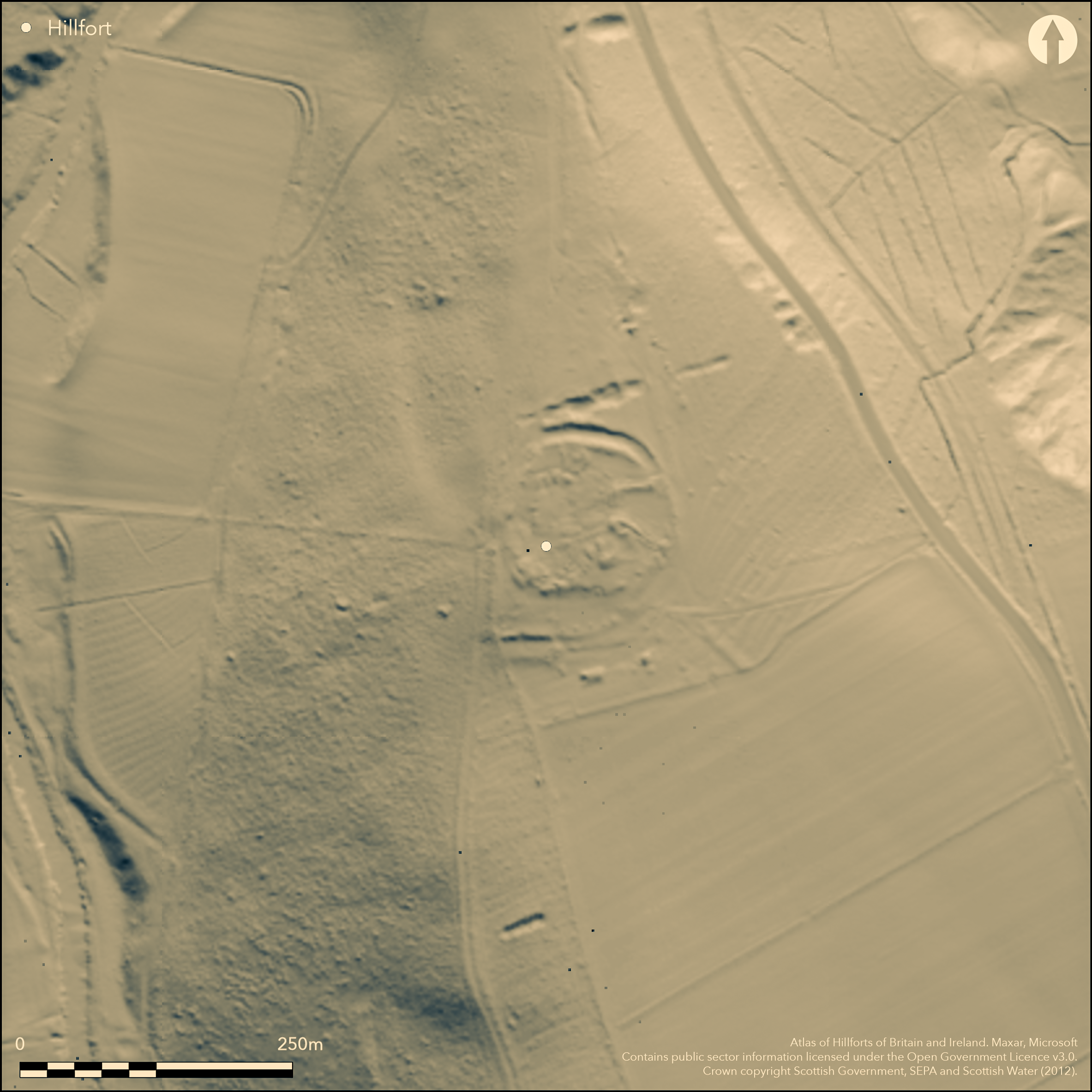
LiDAR 1m DTM Hillshade
Satellite Imagery
LiDAR 1m DTM Hillshade
Satellite Imagery
Scroll left/right to view further images.
HER: Scottish Borders 56917 (None)
NMR: NT 61 SE 2 (56917)
SM: None
NGR: NT 6798 1245
X: 367980 Y: 612450 (OSGB36)
This fort is situated on the crest of a spur above the Jed Water S of Camptown. The configuration of the defences and an overlying late and Roman Iron Age settlement is complex, and confused by subsequent cultivation and a campaign of excavations conducted between 1928-39, so much so that the RCAHMS investigators who drew up a plan in 1938 and 1939 described it as an 'incoherent assemblage of fragmentary structures' (RCAHMS 1956, 225-8, no.457). Nevertheless, at its core is probably a D-shaped enclosure, its interior possibly measuring as much as 97m along the chord formed by the lip of the escarpment dropping down to the Jed Water on the W by 75m transversely (0.65ha) within two ramparts with external ditches up to 4.5m in breadth by between 1.7m and 2.4m in depth; the entrance is on the E. A shallow quarry ditch was found immediately to the rear of the inner rampart around the SE quarter, though in the equivalent position on the N it was V-shaped and 1.8m deep, and on the S a fourth ditch, some 2m deep, was located within the interior. While the RCAHMS investigators suggested the latter was concentric to the outer ditches and therefore part of a single defensive scheme, the scarp of the bank that lies immediately inside it is evidently not concentric on the SW; much more likely this belongs to a separate phase of occupation, though whether earlier or a later insertion into the interior is not clear. What is clear is that this inner enclosure is overlain by a later wall about 2.5m in thickness and still standing 1.3m in height, which appears to form a sub-rectangular enclosure occupying the N two thirds of the interior of the fort, with evidence of a smaller rectilinear enclosure and four stone-founded round-houses lying within it, at least one of which post-dated the smaller enclosure. As recorded by the RCAHMS investigators, and evidently held more widely (Childe 1946, 13-14), the construction of the walls of these enclosures was unusual, the outer incorporating two rows of upright timbers set in individual post-holes, the inner row flush with the inner face of the wall, and the outer set behind the outer wall-face; the wall of the inner enclosure was apparently constructed likewise, though in this case the posts incorporated into the inner face were set in a continuous foundation trench; the walls of the stone-founded round-houses were also thought to incorporate posts set in a continuous ring-groove beneath the core. While not impossible, excavations carried out elsewhere, particularly on rectilinear settlements in Northumberland by George Jobey, would suggest that most of these timber elements were free-standing structures that had been replaced by the walls. Finds from the excavations include a terret, three dress-fasteners, several spiral finger-rings, a penannular brooch, part of a dragonesque brooch and the rim of a vessel, all in bronze, a glass melon bead and fragments of armlets, part of a shale armlet, a denarius of Trajan, four sherds of Samian ware (Robertson 1970, Table 1), sherds of coarse pottery, one saddle quern, fragments of three beehive querns, two crucibles and several spindle whorls and hammerstones; the majority of these finds probably relate to the overlying settlement rather than the fort (Proc Soc Antiq Scot 105, 1972-4, 319, no.17). More recently a small Iron Age copper alloy mount was found on the slope below the fort on the W (Hunter 2000).
Citizen Science: ✗
Reliability of Data: Confirmed
Reliability of Interpretation: Confirmed
X: -279101 Y: 7440862 (EPSG: 3857)
Longitude: -2.507206659957734 Latitude: 55.40496458623442 (EPSG:4326)
Country: Scotland
Current County or Unitary Authority: Scottish Borders
Historic County: Roxburghshire
Current Parish/Community/Council/Townland: Jedburgh
None
| Extant | ✓ |
| Cropmark | ✗ |
| Likely Destroyed | ✗ |
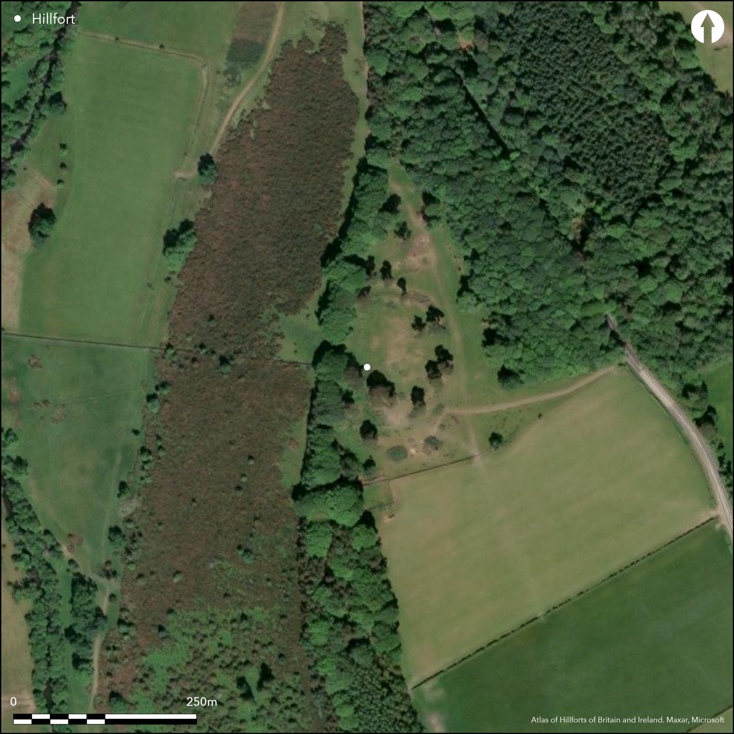
Scattered trees
| Woodland | ✓ |
| Commercial Forestry Plantation | ✗ |
| Parkland | ✗ |
| Pasture (Grazing) | ✓ |
| Arable | ✗ |
| Scrub/Bracken | ✗ |
| Bare Outcrop | ✗ |
| Heather/Moorland | ✗ |
| Heath | ✗ |
| Built-up | ✗ |
| Coastal Grassland | ✗ |
| Other | ✗ |
None
| Contour Fort | ✓ |
| Partial Contour Fort | ✗ |
| Promontory Fort | ✗ |
| Hillslope Fort | ✗ |
| Level Terrain Fort | ✗ |
| Marsh Fort | ✗ |
| Multiple Enclosure Fort | ✗ |
| Hilltop | ✗ |
| Coastal Promontory | ✗ |
| Inland Promontory | ✗ |
| Valley Bottom | ✗ |
| Knoll/Hillock/Outcrop | ✗ |
| Ridge | ✗ |
| Cliff/Plateau-edge/Scarp | ✗ |
| Hillslope | ✗ |
| Lowland | ✗ |
| Spur | ✓ |
Dominant Topographic Feature: None
| North | ✗ |
| Northeast | ✗ |
| East | ✗ |
| Southeast | ✗ |
| South | ✗ |
| Southwest | ✗ |
| West | ✗ |
| Northwest | ✗ |
| Level | ✓ |
Altitude: 220.0m
N/A
There are neither stratified artefacts nor radiocarbon dates to provide a chronology for the defences, though it almost certainly belongs in the pre-Roman Iron Age.
Reliability: D - None
| Pre 1200BC | ✗ |
| 1200BC - 800BC | ✗ |
| 800BC - 400BC | ✗ |
| 400BC - AD50 | ✗ |
| AD50 - AD400 | ✗ |
| AD400 - AD 800 | ✗ |
| Post AD800 | ✗ |
| Unknown | ✓ |
| Pre Hillfort: | None |
| Post Hillfort: | Overlain by a late Iron Age/Roman Iron Age settlement, and subsequently heavily disturbed by cultivation and excavation. Amongst the finds are a series of 14th century items, perhaps from a brief military occupation |
| Artefactual: | Series of finds relating to the Roman Iron Age occupation |
None
| 1st Identified Map Depiction (1859): | Annotated Fort on the 1st edition OS 25-inch map (Roxburgh 1863, sheet 17.11) |
| Excavation (1928): | Mrs F S Oliver, the owner (RCAHMS 1956, 225-8, no.457) |
| Excavation (1929): | Mrs F S Oliver, the owner (RCAHMS 1956, 225-8, no.457) |
| Excavation (1930): | Mrs F S Oliver, the owner (RCAHMS 1956, 225-8, no.457) |
| Excavation (1931): | Mrs F S Oliver, the owner (RCAHMS 1956, 225-8, no.457) |
| Excavation (1932): | Mrs F S Oliver, the owner (RCAHMS 1956, 225-8, no.457) |
| Excavation (1933): | Mrs F S Oliver, the owner (RCAHMS 1956, 225-8, no.457) |
| Excavation (1934): | Mrs F S Oliver, the owner (RCAHMS 1956, 225-8, no.457) |
| Excavation (1935): | Mrs F S Oliver, the owner (RCAHMS 1956, 225-8, no.457) |
| Excavation (1936): | Mrs F S Oliver, the owner (RCAHMS 1956, 225-8, no.457) |
| Excavation (1937): | Mrs F S Oliver, the owner (RCAHMS 1956, 225-8, no.457) |
| Excavation (1938): | Mrs F S Oliver, the owner (RCAHMS 1956, 225-8, no.457) |
| Earthwork Survey (1938): | First survey by RCAHMS |
| Excavation (1939): | Mrs F S Oliver, the owner (RCAHMS 1956, 225-8, no.457) |
| Earthwork Survey (1939): | Revised plan and description (RCAHMS 1956, 225-8, no.457, figs 287-8; RCAHMS RXD 136/1-7) |
| Other (1966): | Resurveyed at 1:2500 by the OS |
| Other (2000): | Iron Age mount found by metal-detecting on the W slopes below the fort (Hunter 2000) |
Largely occupied by a late Iron Age/Roman Iron Age settlement enclosure and at least four stone-founded round-houses, two of which probably overlie timber predecessors.
None
| None | ✓ |
| Spring | ✗ |
| Stream | ✗ |
| Pool | ✗ |
| Flush | ✗ |
| Well | ✗ |
| Other | ✗ |
None
| No Known Features | ✗ |
| Round Stone Structures | ✓ |
| Rectangular Stone Structures | ✗ |
| Curvilinear Platforms | ✗ |
| Other Roundhouse Evidence | ✗ |
| Pits | ✗ |
| Quarry Hollows | ✗ |
| Other | ✗ |
None
| No Known Excavation | ✗ |
| Pits | ✓ |
| Postholes | ✓ |
| Roundhouses | ✓ |
| Rectangular Structures | ✗ |
| Roads/Tracks | ✗ |
| Quarry Hollows | ✗ |
| Other | ✗ |
| Nothing Found | ✗ |
None
| No Known Geophysics | ✓ |
| Pits | ✗ |
| Roundhouses | ✗ |
| Rectangular Structures | ✗ |
| Roads/Tracks | ✗ |
| Quarry Hollows | ✗ |
| Other | ✗ |
| Nothing Found | ✗ |
Finds from the excavations include a terret, three dress-fastners, several spiral finger-rings, a penanular brooch, part of a dragonesque brooch and the rim of a vessel, all in bronze, a glass melon bead and fragments of armlets, part of a shale armlet, a denarius of Trajan, four sherds of Samian ware, sherds of coarse pottery, one saddle quern, fragments of three beehive querns, two crucibles and several spindle whorls and hammerstones; the majority of these finds probably relate to the overlying settlement rather than the fort. More recently a small Iron Age copper alloy mount was found on the slope below the fort on the W (Hunter 2000).
| No Known Finds | ✗ |
| Pottery | ✓ |
| Metal | ✓ |
| Metalworking | ✓ |
| Human Bones | ✗ |
| Animal Bones | ✗ |
| Lithics | ✓ |
| Environmental | ✗ |
| Other | ✓ |
NO APPARENT FEATURES
| APs Not Checked | ✗ |
| None | ✓ |
| Roundhouses | ✗ |
| Rectangular Structures | ✗ |
| Pits | ✗ |
| Postholes | ✗ |
| Roads/Tracks | ✗ |
| Other | ✗ |
See main summary
| 1: | None |
| 2: | None |
Guard Chambers: ✗
Chevaux de Frise: ✗
| 1. Simple Gap (East): | None |
Two ramparts with ditches forming a D-shaped enclosure, within which there is evidence of at least two other periods of enclosure, the later a rectilinear settlement with a robust perimeter wall.
| Area 1: | 0.65ha. |
| Total: | 0.65ha. |
Total Footprint Area: Noneha.
None
| ✓ | The rectilinear settlement clearly overlies the inner enclosure and by implication the rest of the fort. |
| ✗ | The perimeter of the fort is incomplete on the W |
| NE Quadrant: | 2 |
| SE Quadrant: | 3 |
| SW Quadrant: | 3 |
| NW Quadrant: | 1 |
| Total: | 3 |
| Partial Univallate | ✓ |
| Univallate | ✗ |
| Partial Bivallate | ✓ |
| Bivallate | ✗ |
| Partial Multivallate | ✓ |
| Multivallate | ✗ |
| Unknown | ✗ |
| Partial Univallate | ✗ |
| Univallate | ✗ |
| Partial Bivallate | ✗ |
| Bivallate | ✓ |
| Partial Multivallate | ✗ |
| Multivallate | ✗ |
None
| None | ✗ |
| Earthen Bank | ✓ |
| Stone Wall | ✓ |
| Rubble | ✗ |
| Wall-walk | ✗ |
| Evidence of Timber | ✗ |
| Vitrification | ✗ |
| Other Burning | ✗ |
| Palisade | ✗ |
| Counter Scarp Bank | ✗ |
| Berm | ✗ |
| Unfinished | ✗ |
| Other | ✗ |
It is claimed by Childe (1946, 13-14) that the uprights timbers in the wall of the rectilinear enclosures were also braced transversely, there is no other source to confirm this interpretation. These features in any case arguably belong to an overlying rectilinear settlement, albeit that with a wall 2.5m in thickness it was stoutly built.
| None | ✗ |
| Earthen Bank | ✗ |
| Stone Wall | ✓ |
| Murus Duplex | ✗ |
| Timber-framed | ✓ |
| Timber-laced | ✗ |
| Vitrification | ✗ |
| Other Burning | ✗ |
| Palisade | ✓ |
| Counter Scarp Bank | ✗ |
| Berm | ✗ |
| Unfinished | ✗ |
| No Known Excavation | ✗ |
| Other | ✗ |
| ✗ | None |
| ✓ | None |
Number of Ditches: 4
| ✗ | None |
Childe, V G (1946) Scotland before the Scots: being the Rhind lectures 1944. London
Hunter, F (2000) 'Camps, Edgerston, Scottish Borders (Jedburgh parish), Iron Age mount'. Disc Exc Scot 1, New Ser (2000), 76
RCAHMS (1956) The Royal Commission on the Ancient and Historical Monuments of Scotland. An inventory of the ancient and historical monuments of Roxburghshire: with the fourteenth report of the Commission, 2v. HMSO: Edinburgh
Robertson, A S (1970) 'Roman finds from non-Roman sites in Scotland' Britannia 1 (1970), 198-226
Robertson, A S (1984) 'Roman coins found in Scotland, 1971-1982'. Proc Soc Antiq Scot 113 (1983), 405-48 (Table 3)
Atlas of Hillforts:
Wikidata:
This work is licensed under CC BY-SA 4.0![]()
![]()
![]() and should be cited as:
and should be cited as:
Lock, Gary and Ralston, Ian. 2024. Atlas of Hillforts of Britain and Ireland. Available at: https://hillforts.arch.ox.ac.uk
Document Version 1.1