
LiDAR 1m DTM Hillshade
Satellite Imagery
LiDAR 1m DTM Hillshade
Satellite Imagery
Scroll left/right to view further images.
HER: Scottish Borders 56959 (None)
NMR: NT 62 NE 2 (56959)
SM: 1703
NGR: NT 6535 2630
X: 365350 Y: 626300 (OSGB36)
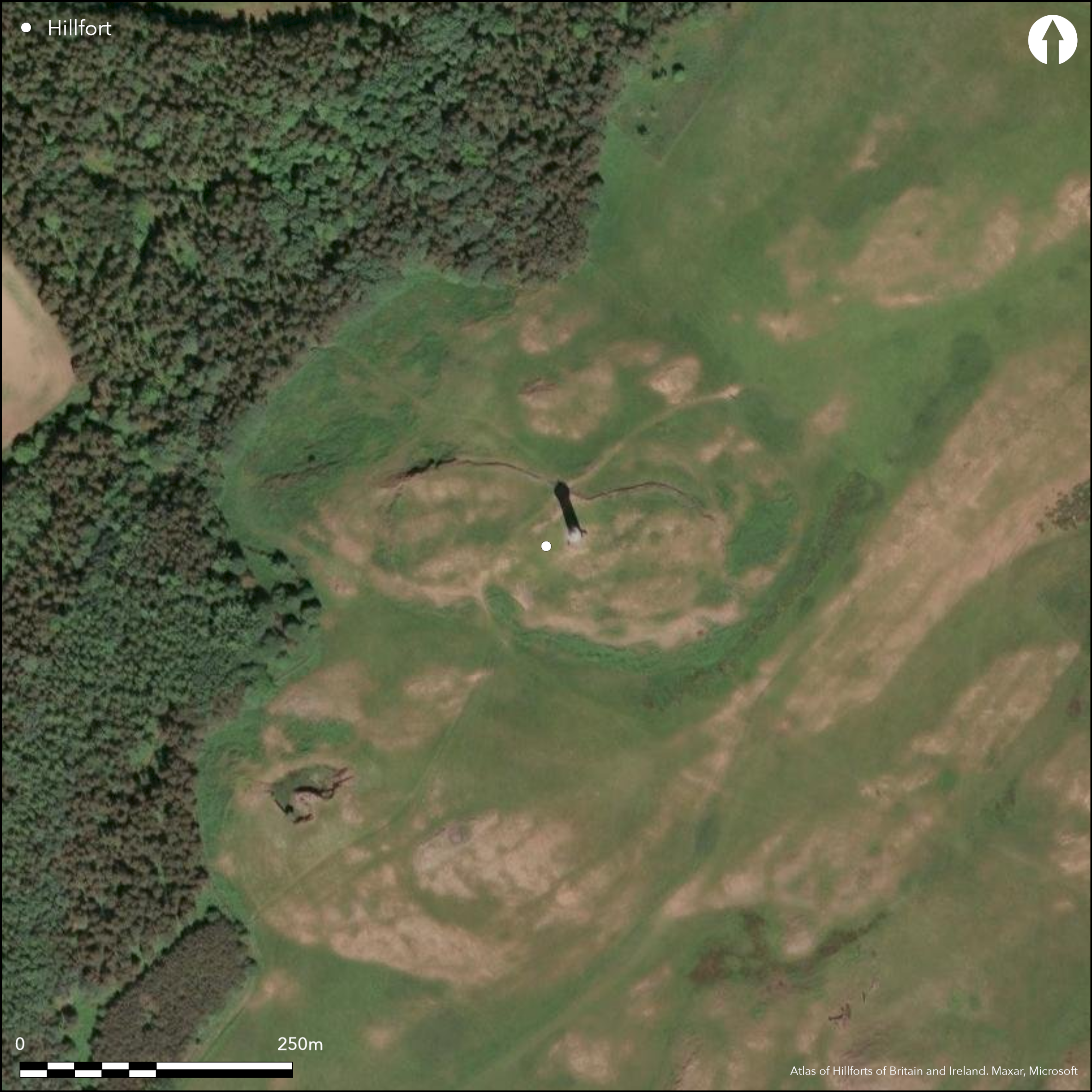
A complex sequence of fortifications can be seen on the summit of Peniel Heugh, a well-known landmark crowned by a tower built to commemorate the Battle of Waterloo. The earliest is probably a bivallate work occupying the higher part of the summit on the E, while the latest comprises a single wall taking in the whole of the summit area. This latter wall incorporates a series of massive stones up to 1m high set up on end in its outer face; these can be seen along the N side, where the rubbles has been pulled back and the face has also been rebuilt to a height of up to 1.8m. Roughly oval on plan, this latest fort measures about 175m from WNW to ESE by a maximum of 75m transversely (1.1ha). On the E and S its wall follows the crags along the edge of the summit and a track that mounts the slope via a broad causeway in a ditch dug into the foot of the slope below them on the S is probably reusing an original entrance; the gateway in a rebuilt length of wall on the opposite side of the fort on the N may mark a second. While this fort is clearly set out eccentrically across the earliest fort, it is evidently not the first fortification to have taken this line. At the far WNW end, above a small D-shaped annexe taking in a lower terrace, there are fragmentary remains of a wall extending along the crest of the slope. Its likely course has been adopted by the wall of the latest fort on the N, thus implying another enclosure of a similar size; its E end is perhaps represented by another fragmentary wall, which can be traced southwards from a curious re-entrant on the ENE where the latest fort wall has been re-aligned to drop down to the crag at this end. The defences of the earliest fort apparently contour round the E end of the summit, but the defences are only clearly visible outside the latest fort wall on the NE. For the most part both ramparts have been reduced to no more that scarps, but on the NW side of an entrance preserved on the NE, the inner forms a bank 4.5m in thickness by up to 1.2m in height. The oval interior, which measures about 105m from NE to SW by 80m transversely (0.65ha), is traversed by a post-medieval field-bank and has probably been cultivated.
Citizen Science: ✗
Reliability of Data: Confirmed
Reliability of Interpretation: Confirmed
X: -283917 Y: 7465264 (EPSG: 3857)
Longitude: -2.550468806287016 Latitude: 55.52923082789554 (EPSG:4326)
Country: Scotland
Current County or Unitary Authority: Scottish Borders
Historic County: Roxburghshire
Current Parish/Community/Council/Townland: Crailing
None
| Extant | ✓ |
| Cropmark | ✗ |
| Likely Destroyed | ✗ |
None
| Woodland | ✗ |
| Commercial Forestry Plantation | ✗ |
| Parkland | ✗ |
| Pasture (Grazing) | ✓ |
| Arable | ✗ |
| Scrub/Bracken | ✗ |
| Bare Outcrop | ✗ |
| Heather/Moorland | ✓ |
| Heath | ✗ |
| Built-up | ✗ |
| Coastal Grassland | ✗ |
| Other | ✗ |
None
| Contour Fort | ✓ |
| Partial Contour Fort | ✗ |
| Promontory Fort | ✗ |
| Hillslope Fort | ✗ |
| Level Terrain Fort | ✗ |
| Marsh Fort | ✗ |
| Multiple Enclosure Fort | ✗ |
| Hilltop | ✓ |
| Coastal Promontory | ✗ |
| Inland Promontory | ✗ |
| Valley Bottom | ✗ |
| Knoll/Hillock/Outcrop | ✗ |
| Ridge | ✗ |
| Cliff/Plateau-edge/Scarp | ✗ |
| Hillslope | ✗ |
| Lowland | ✗ |
| Spur | ✗ |
Dominant Topographic Feature: Prominent landmark in this part of the Tweed, with panoramic views round the whole of the Tweed basin
| North | ✗ |
| Northeast | ✗ |
| East | ✗ |
| Southeast | ✗ |
| South | ✗ |
| Southwest | ✗ |
| West | ✗ |
| Northwest | ✗ |
| Level | ✓ |
Altitude: 237.0m
N/A
Identified by RCAHMS investigators as a Dark Age fort (RCAHMS 1956, 35), their reasoning, partly founded on the supposed sequence of fortification found at Hownam Rings, and partly in comparison to Rubers Law, can no longer be sustained. The date of the fort can only be established by excavation.
Reliability: D - None
| Pre 1200BC | ✗ |
| 1200BC - 800BC | ✗ |
| 800BC - 400BC | ✗ |
| 400BC - AD50 | ✗ |
| AD50 - AD400 | ✗ |
| AD400 - AD 800 | ✗ |
| Post AD800 | ✗ |
| Unknown | ✓ |
| Pre Hillfort: | Mesolithic flint recovered from a mole-hill (Parkhouse 2006) |
| Post Hillfort: | Overlain by several post-medieval field-banks and the Waterloo Monument |
Photographed by RCAHMS Aerial Survey Programme in 1982, 1984 and 2010
| 1st Identified Written Reference (1792): | Noted (Stat Acct ii, 1792, 331) |
| 1st Identified Map Depiction (1859): | Annotated Camp on the 1st edition OS 25-inch map (Roxburgh 1863, sheet 15.5) |
| Earthwork Survey (1949): | Plan and description (RCAHMS 1956, 124-6, no.201, fig 163; RCAHMS RXD 103/1-2) |
| Other (1958): | Scheduled |
| Other (1963): | Revised at 1:2500 by the OS |
| Other (2006): | Mesolithic flint found (Parkhouse 2006) |
Apart from the Waterloo Monument on the summit the only features visible within the interior are the remains of post-medieval field-banks
None
| None | ✓ |
| Spring | ✗ |
| Stream | ✗ |
| Pool | ✗ |
| Flush | ✗ |
| Well | ✗ |
| Other | ✗ |
None
| No Known Features | ✓ |
| Round Stone Structures | ✗ |
| Rectangular Stone Structures | ✗ |
| Curvilinear Platforms | ✗ |
| Other Roundhouse Evidence | ✗ |
| Pits | ✗ |
| Quarry Hollows | ✗ |
| Other | ✗ |
None
| No Known Excavation | ✓ |
| Pits | ✗ |
| Postholes | ✗ |
| Roundhouses | ✗ |
| Rectangular Structures | ✗ |
| Roads/Tracks | ✗ |
| Quarry Hollows | ✗ |
| Other | ✗ |
| Nothing Found | ✗ |
None
| No Known Geophysics | ✓ |
| Pits | ✗ |
| Roundhouses | ✗ |
| Rectangular Structures | ✗ |
| Roads/Tracks | ✗ |
| Quarry Hollows | ✗ |
| Other | ✗ |
| Nothing Found | ✗ |
Mesolithic flint (Parkhouse 2006)
| No Known Finds | ✗ |
| Pottery | ✗ |
| Metal | ✗ |
| Metalworking | ✗ |
| Human Bones | ✗ |
| Animal Bones | ✗ |
| Lithics | ✓ |
| Environmental | ✗ |
| Other | ✗ |
NO APPARENT FEATURES
| APs Not Checked | ✗ |
| None | ✓ |
| Roundhouses | ✗ |
| Rectangular Structures | ✗ |
| Pits | ✗ |
| Postholes | ✗ |
| Roads/Tracks | ✗ |
| Other | ✗ |
See main summary
| 3: | Through all defences |
| 2: | Two into the later fort (1-2), and one identified in the earlier fort (3) |
Guard Chambers: ✗
Chevaux de Frise: ✗
| 1. Simple Gap (North): | Possible entrance where the wall of the later fort has been rebuilt relatively recently with a gateway. |
| 2. Simple Gap (South): | Gap in the wall of the later fort adopted by the modern track |
| 3. Simple Gap (North east): | Through both the ramparts of the earlier fort |
An earlier fort with twin ramparts, and a later fort with a single stone wall; other short lengths of defensive walls within the interior may belong to other configurations of defences on the hill
| Area 1: | 0.65ha. |
| Area 2: | 1.1ha. |
| Total: | 1.1ha. |
Total Footprint Area: 1.18ha.
None
| ✓ | The univallate fort clearly succeeds the bivallate fort, but there are also traces of other lines of defence that belong to neither |
| ✓ | Essentially two circuits, one with a single wall and the other with twin ramparts |
| NE Quadrant: | 3 |
| SE Quadrant: | 2 |
| SW Quadrant: | 2 |
| NW Quadrant: | 1 |
| Total: | 3 |
| Partial Univallate | ✓ |
| Univallate | ✗ |
| Partial Bivallate | ✓ |
| Bivallate | ✗ |
| Partial Multivallate | ✓ |
| Multivallate | ✗ |
| Unknown | ✗ |
| Partial Univallate | ✗ |
| Univallate | ✓ |
| Partial Bivallate | ✗ |
| Bivallate | ✓ |
| Partial Multivallate | ✗ |
| Multivallate | ✗ |
None
| None | ✗ |
| Earthen Bank | ✗ |
| Stone Wall | ✓ |
| Rubble | ✓ |
| Wall-walk | ✗ |
| Evidence of Timber | ✗ |
| Vitrification | ✗ |
| Other Burning | ✗ |
| Palisade | ✗ |
| Counter Scarp Bank | ✗ |
| Berm | ✗ |
| Unfinished | ✗ |
| Other | ✗ |
None
| None | ✗ |
| Earthen Bank | ✗ |
| Stone Wall | ✗ |
| Murus Duplex | ✗ |
| Timber-framed | ✗ |
| Timber-laced | ✗ |
| Vitrification | ✗ |
| Other Burning | ✗ |
| Palisade | ✗ |
| Counter Scarp Bank | ✗ |
| Berm | ✗ |
| Unfinished | ✗ |
| No Known Excavation | ✓ |
| Other | ✗ |
| ✗ | None |
| ✗ | None |
Number of Ditches: None
| ✓ | There is a small annexe taking in a lower terrace at the W end, reminiscent of the annexes at Yeavering Bell in Northumberland and the White Meldon in Peeblesshire. D-shaped on plan, it measures about 35m from E to W by 28m transversely along the chord (0.05ha). It is unclear whether it is merely a tactical addition to the defences of the latest fort, or whether it is associated with another fragmentary, and presumably earlier line of defence at this end of the fort |
Stat Acct (date) Statistical Account of Scotland: Drawn up from the Communications of the Ministers of the Different Parishes (Sinclair, J ed), 1791-99
RCAHMS (1956) The Royal Commission on the Ancient and Historical Monuments of Scotland. An inventory of the ancient and historical monuments of Roxburghshire: with the fourteenth report of the Commission, 2v. HMSO: Edinburgh
Atlas of Hillforts:
Wikidata:
This work is licensed under CC BY-SA 4.0![]()
![]()
![]() and should be cited as:
and should be cited as:
Lock, Gary and Ralston, Ian. 2024. Atlas of Hillforts of Britain and Ireland. Available at: https://hillforts.arch.ox.ac.uk
Document Version 1.1