Satellite Imagery
Satellite Imagery
HER: Scottish Borders 57955 (None)
NMR: NT 71 NE 4 (57955)
SM: 1705
NGR: NT 7654 1928
X: 376540 Y: 619280 (OSGB36)
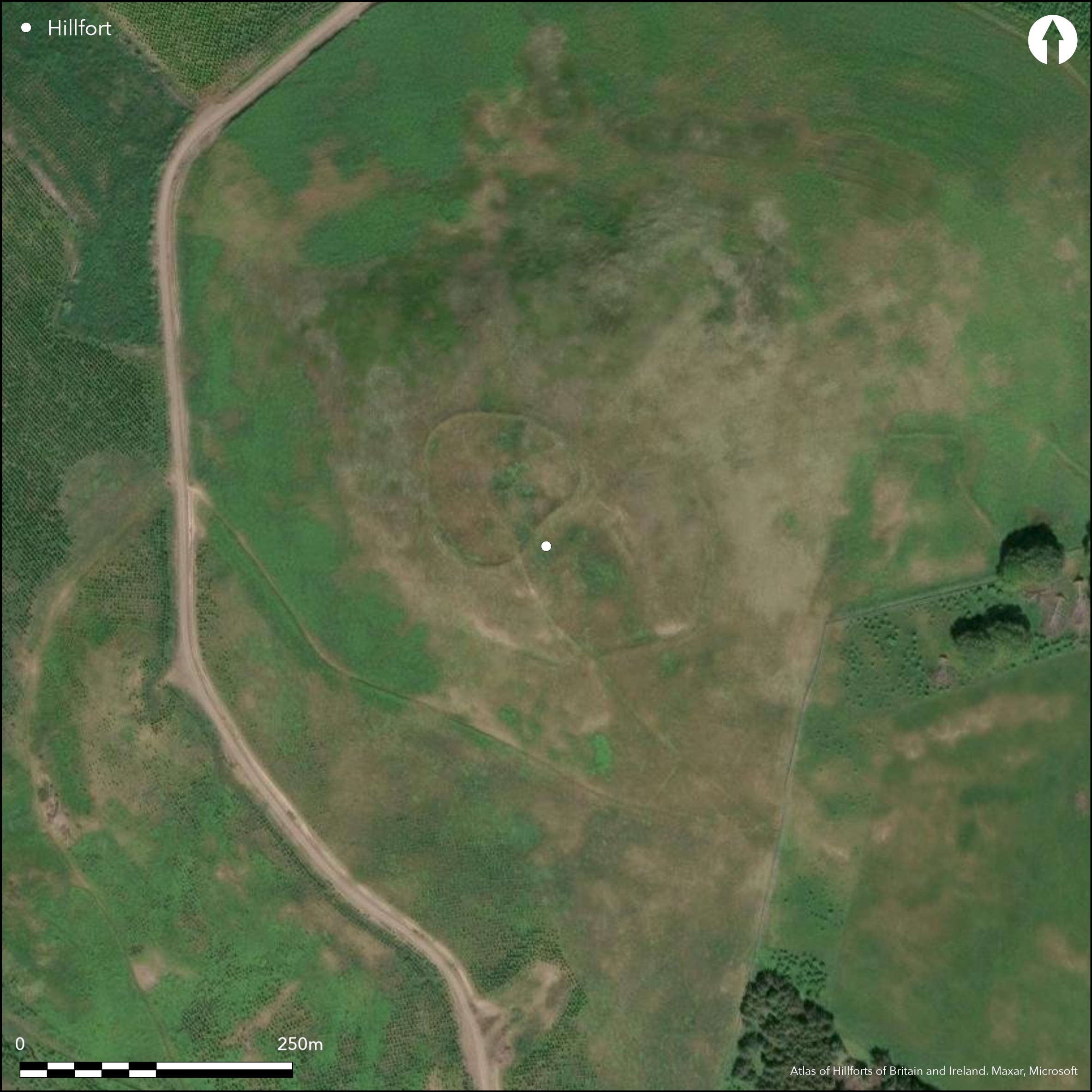
This fort is situated on the summit of Thowliestane Hill, a steep hill overlooking Hownam from the W. Heart-shaped on plan, it measures about 75m from NE to SW by 70m transversely (0.43ha) within a rampart forming a low mound up to 6m in thickness by 0.6m in height. An external ditch is visible on the NE and S, where there are also the remains of an outer rampart; the latter has short segments of an external ditch on the E and S. In addition to these inner defences, there are a series of outlying banks and ditches on the SE, where two natural ridges of rock extend away from the E and S angles of the fort, flanking a broad gully running up to the entrance. These include a bank extending down the spine of the W ridge, a bank and ditch cutting at right-angles across the eastern ridge, and an outlying earthwork which crosses the bottom of the gully, where it is broken by an entrance, and carries on round to peter out on the E and SW flanks of the fort respectively. How these relate to the defences of the fort is unknown, though the last is a substantial barrier with a ditch up to 6m in breadth and a counterscarp bank on its downslope side; on the slope above the ditch on the E side of the eastern ridge of rock there is also a possible length of palisade trench, though it quickly disappears in a patch of cord rig. Within the interior of the fort there are two stone founded round-houses, one lying roughly at the centre, with low banks radiating on the NNW and ENE to form a small enclosure, and the second on its NNW; these are likely to represent a late Iron Age occupation.
Citizen Science: ✗
Reliability of Data: Confirmed
Reliability of Interpretation: Confirmed
X: -264118 Y: 7452999 (EPSG: 3857)
Longitude: -2.3726079343147712 Latitude: 55.466821401810535 (EPSG:4326)
Country: Scotland
Current County or Unitary Authority: Scottish Borders
Historic County: Roxburghshire
Current Parish/Community/Council/Townland: Hownam
None
| Extant | ✓ |
| Cropmark | ✗ |
| Likely Destroyed | ✗ |
None
| Woodland | ✗ |
| Commercial Forestry Plantation | ✗ |
| Parkland | ✗ |
| Pasture (Grazing) | ✓ |
| Arable | ✗ |
| Scrub/Bracken | ✗ |
| Bare Outcrop | ✗ |
| Heather/Moorland | ✓ |
| Heath | ✗ |
| Built-up | ✗ |
| Coastal Grassland | ✗ |
| Other | ✗ |
None
| Contour Fort | ✓ |
| Partial Contour Fort | ✗ |
| Promontory Fort | ✗ |
| Hillslope Fort | ✗ |
| Level Terrain Fort | ✗ |
| Marsh Fort | ✗ |
| Multiple Enclosure Fort | ✗ |
| Hilltop | ✓ |
| Coastal Promontory | ✗ |
| Inland Promontory | ✗ |
| Valley Bottom | ✗ |
| Knoll/Hillock/Outcrop | ✗ |
| Ridge | ✗ |
| Cliff/Plateau-edge/Scarp | ✗ |
| Hillslope | ✗ |
| Lowland | ✗ |
| Spur | ✗ |
Dominant Topographic Feature: None
| North | ✗ |
| Northeast | ✗ |
| East | ✗ |
| Southeast | ✗ |
| South | ✗ |
| Southwest | ✗ |
| West | ✗ |
| Northwest | ✗ |
| Level | ✓ |
Altitude: 313.0m
N/A
In the absence of excavation, there are neither stratified artefacts nor radiocarbon dates to provide a chronology for the defences.
Reliability: D - None
| Pre 1200BC | ✗ |
| 1200BC - 800BC | ✗ |
| 800BC - 400BC | ✗ |
| 400BC - AD50 | ✗ |
| AD50 - AD400 | ✗ |
| AD400 - AD 800 | ✗ |
| Post AD800 | ✗ |
| Unknown | ✓ |
| Pre Hillfort: | None |
| Post Hillfort: | probably overlain by a late Iron Age settlement of stone-founded round-houses. |
Photographed by Dennis Harding in 1982, by John Dent in 1992, and by RCAHMS Aerial Survey Programme in 1992, 2000 and 2010.
| 1st Identified Map Depiction (1859): | Annotated Camp in Roman Type on the 1st edition OS 25-inch map (Roxburgh 1863, 22.10) |
| Other (1884): | Noted (Geikie 1884, 140) |
| Earthwork Survey (1938): | Plan and description (RCAHMS 1956, 159-60, no.300, fig 186) |
| Other (1958): | Scheduled |
| Other (1968): | Visited by the OS |
| Other (1973): | Visited by the OS |
| Other (1999): | Description by RCAHMS |
Two stone-founded round-houses probably relating to a late Iron Age occupation
None
| None | ✓ |
| Spring | ✗ |
| Stream | ✗ |
| Pool | ✗ |
| Flush | ✗ |
| Well | ✗ |
| Other | ✗ |
None
| No Known Features | ✗ |
| Round Stone Structures | ✓ |
| Rectangular Stone Structures | ✗ |
| Curvilinear Platforms | ✗ |
| Other Roundhouse Evidence | ✗ |
| Pits | ✗ |
| Quarry Hollows | ✗ |
| Other | ✗ |
None
| No Known Excavation | ✓ |
| Pits | ✗ |
| Postholes | ✗ |
| Roundhouses | ✗ |
| Rectangular Structures | ✗ |
| Roads/Tracks | ✗ |
| Quarry Hollows | ✗ |
| Other | ✗ |
| Nothing Found | ✗ |
None
| No Known Geophysics | ✓ |
| Pits | ✗ |
| Roundhouses | ✗ |
| Rectangular Structures | ✗ |
| Roads/Tracks | ✗ |
| Quarry Hollows | ✗ |
| Other | ✗ |
| Nothing Found | ✗ |
None
| No Known Finds | ✓ |
| Pottery | ✗ |
| Metal | ✗ |
| Metalworking | ✗ |
| Human Bones | ✗ |
| Animal Bones | ✗ |
| Lithics | ✗ |
| Environmental | ✗ |
| Other | ✗ |
NO APPARENT FEATURES
| APs Not Checked | ✗ |
| None | ✗ |
| Roundhouses | ✓ |
| Rectangular Structures | ✗ |
| Pits | ✗ |
| Postholes | ✗ |
| Roads/Tracks | ✗ |
| Other | ✗ |
See main summary
| 1: | None |
| 2: | None |
Guard Chambers: ✗
Chevaux de Frise: ✗
| 1. Simple Gap (South east): | None |
Up to two ramparts and ditches
| Area 1: | 0.43ha. |
| Total: | 0.43ha. |
Total Footprint Area: Noneha.
None
| ✗ | None |
| ✓ | This omits the outlying features |
| NE Quadrant: | 2 |
| SE Quadrant: | 2 |
| SW Quadrant: | 1 |
| NW Quadrant: | 1 |
| Total: | 2 |
| Partial Univallate | ✓ |
| Univallate | ✗ |
| Partial Bivallate | ✓ |
| Bivallate | ✗ |
| Partial Multivallate | ✗ |
| Multivallate | ✗ |
| Unknown | ✗ |
| Partial Univallate | ✗ |
| Univallate | ✗ |
| Partial Bivallate | ✗ |
| Bivallate | ✗ |
| Partial Multivallate | ✗ |
| Multivallate | ✗ |
The palisade trench is probably associated with the outlying ditch and bank on the SW
| None | ✗ |
| Earthen Bank | ✓ |
| Stone Wall | ✗ |
| Rubble | ✗ |
| Wall-walk | ✗ |
| Evidence of Timber | ✗ |
| Vitrification | ✗ |
| Other Burning | ✗ |
| Palisade | ✓ |
| Counter Scarp Bank | ✗ |
| Berm | ✗ |
| Unfinished | ✗ |
| Other | ✗ |
None
| None | ✗ |
| Earthen Bank | ✗ |
| Stone Wall | ✗ |
| Murus Duplex | ✗ |
| Timber-framed | ✗ |
| Timber-laced | ✗ |
| Vitrification | ✗ |
| Other Burning | ✗ |
| Palisade | ✗ |
| Counter Scarp Bank | ✗ |
| Berm | ✗ |
| Unfinished | ✗ |
| No Known Excavation | ✓ |
| Other | ✗ |
| ✗ | None |
| ✓ | The medial ditch is possibly a more continuous feature but the outer is just two short segments and omitted |
Number of Ditches: 1
| ✗ | The outlying earthwork on the SE is conceivaly an annexe but does not form a complete enclosure |
Geikie, J (1884) «List of hill forts, intrenched camps, etc. in Roxburghshire on the Scotch side of the Cheviots». Hist Berwickshire Natur Club 10 (1882-4) 139-44
RCAHMS (1956) The Royal Commission on the Ancient and Historical Monuments of Scotland. An inventory of the ancient and historical monuments of Roxburghshire: with the fourteenth report of the Commission, 2v. HMSO: Edinburgh
Atlas of Hillforts:
Wikidata:
This work is licensed under CC BY-SA 4.0![]()
![]()
![]() and should be cited as:
and should be cited as:
Lock, Gary and Ralston, Ian. 2024. Atlas of Hillforts of Britain and Ireland. Available at: https://hillforts.arch.ox.ac.uk
Document Version 1.1