Satellite Imagery
Satellite Imagery
HER: Scottish Borders 57925 (None)
NMR: NT 71 NE 12 (57925)
SM: 4852
NGR: NT 7960 1690
X: 379600 Y: 616900 (OSGB36)
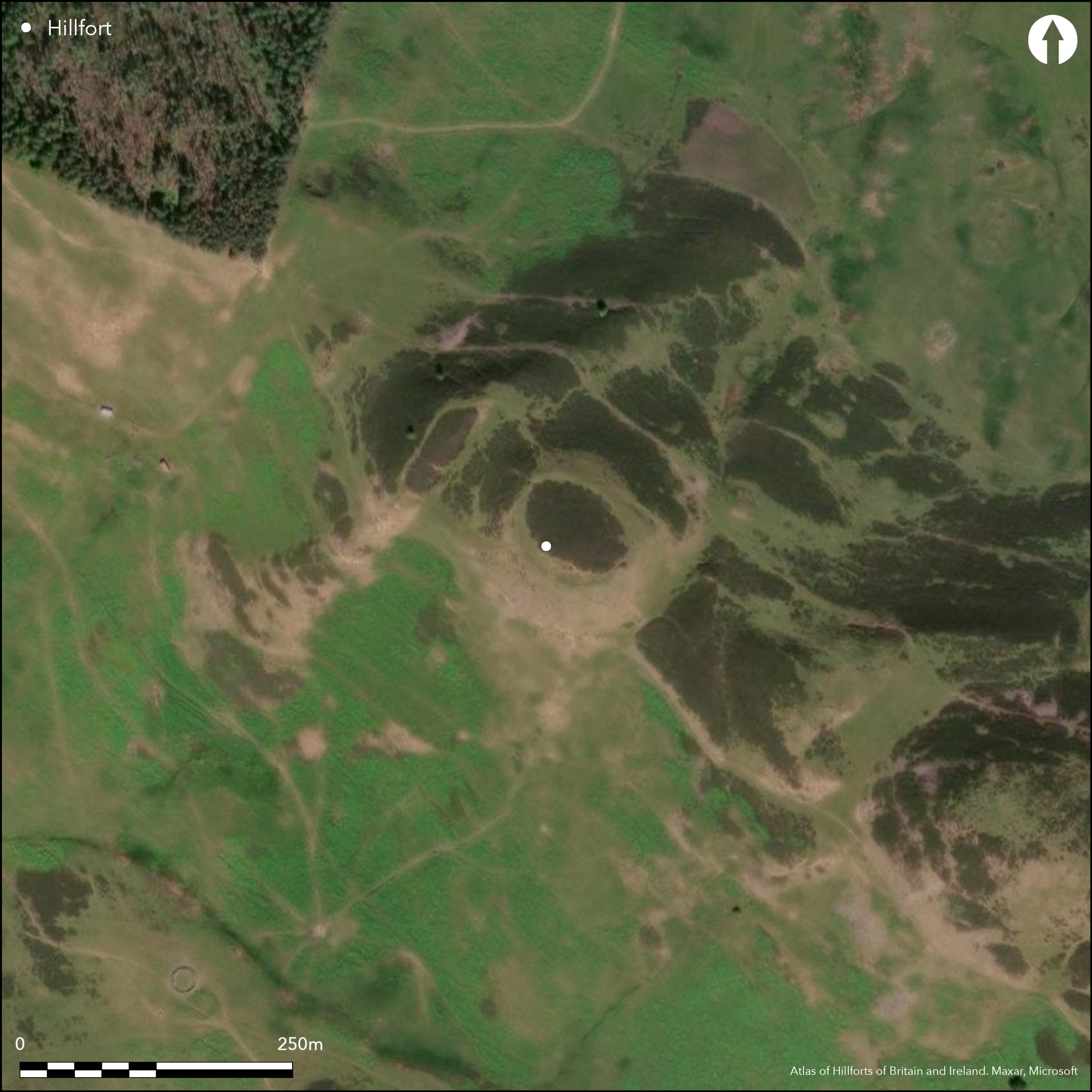
This fort is situated on the NE spur of Green Hill, which forms a steep-sided ridge separating the valleys of the Mainhope Burn from the Heatherhope Burn. Its defences comprise two elements, namely a single rampart enclosing the summit of a knoll on the ridge, and another rampart enclosing an annexe on the NW. The enclosure on the summit measures internally about 62m from NW to SE by 50m transversely (0.24ha), and its rampart has been largely reduced to a scree of grass-grown rubble around the lip of the knoll, along which occasional inner facing-stones can be seen, including a short run on the S. There are two entrances, one allowing access off the spine of the ridge on the SE, and the other opening into the annexe on the NW. The latter forms a roughly rectangular enclosure, taking in the shallow saddle to the NW and a rib of outcrop immediately to its NW, and measures internally a maximum of 65m from NE to SW by 58m transversely (0.35ha). Its rampart springs from the rubble of the main wall of the fort on the NNW, is pierced by an entrance on the NE, and returns to the fort on the W, where it is apparently accompanied by an outer bank. The relationship between the annexe and the fort is unclear, though the configuration on the plan would suggest that it is an addition, in which case it should perhaps be regarded as a free-standing rectilinear settlement enclosure, rather than a subsidiary element in the defences of the fort. The interiors of both are featureless.
Citizen Science: ✗
Reliability of Data: Confirmed
Reliability of Interpretation: Confirmed
X: -258710 Y: 7448828 (EPSG: 3857)
Longitude: -2.3240342518314305 Latitude: 55.4455736012174 (EPSG:4326)
Country: Scotland
Current County or Unitary Authority: Scottish Borders
Historic County: Roxburghshire
Current Parish/Community/Council/Townland: Hownam
None
| Extant | ✓ |
| Cropmark | ✗ |
| Likely Destroyed | ✗ |
None
| Woodland | ✗ |
| Commercial Forestry Plantation | ✗ |
| Parkland | ✗ |
| Pasture (Grazing) | ✓ |
| Arable | ✗ |
| Scrub/Bracken | ✗ |
| Bare Outcrop | ✗ |
| Heather/Moorland | ✓ |
| Heath | ✗ |
| Built-up | ✗ |
| Coastal Grassland | ✗ |
| Other | ✗ |
None
| Contour Fort | ✓ |
| Partial Contour Fort | ✗ |
| Promontory Fort | ✗ |
| Hillslope Fort | ✗ |
| Level Terrain Fort | ✗ |
| Marsh Fort | ✗ |
| Multiple Enclosure Fort | ✗ |
| Hilltop | ✓ |
| Coastal Promontory | ✗ |
| Inland Promontory | ✗ |
| Valley Bottom | ✗ |
| Knoll/Hillock/Outcrop | ✗ |
| Ridge | ✗ |
| Cliff/Plateau-edge/Scarp | ✗ |
| Hillslope | ✗ |
| Lowland | ✗ |
| Spur | ✓ |
Dominant Topographic Feature: None
| North | ✗ |
| Northeast | ✗ |
| East | ✗ |
| Southeast | ✗ |
| South | ✗ |
| Southwest | ✗ |
| West | ✗ |
| Northwest | ✗ |
| Level | ✓ |
Altitude: 305.0m
N/A
In the absence of excavation, there are neither stratified artefacts nor radiocarbon dates to provide a chronology for the defences.
Reliability: D - None
| Pre 1200BC | ✗ |
| 1200BC - 800BC | ✗ |
| 800BC - 400BC | ✗ |
| 400BC - AD50 | ✗ |
| AD50 - AD400 | ✗ |
| AD400 - AD 800 | ✗ |
| Post AD800 | ✗ |
| Unknown | ✓ |
| Pre Hillfort: | None |
| Post Hillfort: | None |
Photographed by RCAHMS Aerial Survey Programme in 1993 and 2010
| 1st Identified Map Depiction (1859): | Annotated Fort on the 1st edition OS 25-inch map (Roxburgh 1863, sheet 22.15) |
| Other (1884): | Noted (Geikie 1884, 141) |
| Earthwork Survey (1938): | Plan and description (RCAHMS 1956, 163-4, no.304, fig 190; RCAHMS RXD 121/1-2) |
| Other (1979): | Surveyed at 1:10,000 by the OS |
| Other (1990): | Scheduled |
Featureless
None
| None | ✓ |
| Spring | ✗ |
| Stream | ✗ |
| Pool | ✗ |
| Flush | ✗ |
| Well | ✗ |
| Other | ✗ |
None
| No Known Features | ✓ |
| Round Stone Structures | ✗ |
| Rectangular Stone Structures | ✗ |
| Curvilinear Platforms | ✗ |
| Other Roundhouse Evidence | ✗ |
| Pits | ✗ |
| Quarry Hollows | ✗ |
| Other | ✗ |
None
| No Known Excavation | ✓ |
| Pits | ✗ |
| Postholes | ✗ |
| Roundhouses | ✗ |
| Rectangular Structures | ✗ |
| Roads/Tracks | ✗ |
| Quarry Hollows | ✗ |
| Other | ✗ |
| Nothing Found | ✗ |
None
| No Known Geophysics | ✓ |
| Pits | ✗ |
| Roundhouses | ✗ |
| Rectangular Structures | ✗ |
| Roads/Tracks | ✗ |
| Quarry Hollows | ✗ |
| Other | ✗ |
| Nothing Found | ✗ |
None
| No Known Finds | ✓ |
| Pottery | ✗ |
| Metal | ✗ |
| Metalworking | ✗ |
| Human Bones | ✗ |
| Animal Bones | ✗ |
| Lithics | ✗ |
| Environmental | ✗ |
| Other | ✗ |
NO APPARENT FEATURES
| APs Not Checked | ✗ |
| None | ✓ |
| Roundhouses | ✗ |
| Rectangular Structures | ✗ |
| Pits | ✗ |
| Postholes | ✗ |
| Roads/Tracks | ✗ |
| Other | ✗ |
See main summary
| 3: | None |
| 2: | Generalised to two into the fort (1-2); another provides access into the annexe |
Guard Chambers: ✗
Chevaux de Frise: ✗
| 1. Simple Gap (South east): | Into fort |
| 2. Simple Gap (North west): | Between fort and annexe |
| 3. Simple Gap (North east): | Into the annexe, and also giving access into the interior of the fort |
Single rampart
| Area 1: | 0.24ha. |
| Total: | 0.24ha. |
Total Footprint Area: 0.82ha.
None
| ✗ | None |
| ✓ | None |
| NE Quadrant: | 1 |
| SE Quadrant: | 1 |
| SW Quadrant: | 1 |
| NW Quadrant: | 2 |
| Total: | 2 |
| Partial Univallate | ✓ |
| Univallate | ✗ |
| Partial Bivallate | ✓ |
| Bivallate | ✗ |
| Partial Multivallate | ✗ |
| Multivallate | ✗ |
| Unknown | ✗ |
| Partial Univallate | ✗ |
| Univallate | ✗ |
| Partial Bivallate | ✗ |
| Bivallate | ✗ |
| Partial Multivallate | ✗ |
| Multivallate | ✗ |
None
| None | ✗ |
| Earthen Bank | ✗ |
| Stone Wall | ✓ |
| Rubble | ✗ |
| Wall-walk | ✗ |
| Evidence of Timber | ✗ |
| Vitrification | ✗ |
| Other Burning | ✗ |
| Palisade | ✗ |
| Counter Scarp Bank | ✗ |
| Berm | ✗ |
| Unfinished | ✗ |
| Other | ✗ |
None
| None | ✗ |
| Earthen Bank | ✗ |
| Stone Wall | ✗ |
| Murus Duplex | ✗ |
| Timber-framed | ✗ |
| Timber-laced | ✗ |
| Vitrification | ✗ |
| Other Burning | ✗ |
| Palisade | ✗ |
| Counter Scarp Bank | ✗ |
| Berm | ✗ |
| Unfinished | ✗ |
| No Known Excavation | ✓ |
| Other | ✗ |
| ✗ | None |
| ✗ | None |
Number of Ditches: None
| ✓ | The annexe forms a roughly rectangular enclosure, taking in the shallow saddle to the NW and a rib of outcrop immediately to its NW. Defended by a single rampart, which springs from the rubble of the main wall on the NNW of the fort and returns on the W, it measures internally a maximum of 65m from NE to SW by 58m transversely (0.35ha). There is an entrance on the NE and the interior is featureless. The relationship between the annexe and the fort is unclear, though the configuration on the plan would suggest that it is an addition. Annexes such as this are very unusual and it is perhaps more likely that this is the remains of an independent rectilinear settlement enclosure. |
Geikie, J (1884) «List of hill forts, intrenched camps, etc. in Roxburghshire on the Scotch side of the Cheviots». Hist Berwickshire Natur Club 10 (1882-4) 139-44
RCAHMS (1956) The Royal Commission on the Ancient and Historical Monuments of Scotland. An inventory of the ancient and historical monuments of Roxburghshire: with the fourteenth report of the Commission, 2v. HMSO: Edinburgh
Atlas of Hillforts:
Wikidata:
This work is licensed under CC BY-SA 4.0![]()
![]()
![]() and should be cited as:
and should be cited as:
Lock, Gary and Ralston, Ian. 2024. Atlas of Hillforts of Britain and Ireland. Available at: https://hillforts.arch.ox.ac.uk
Document Version 1.1