Satellite Imagery
Satellite Imagery
HER: Scottish Borders 58078 (None)
NMR: NT 71 SE 24 (58078)
SM: 2157
NGR: NT 7784 1364
X: 377840 Y: 613640 (OSGB36)
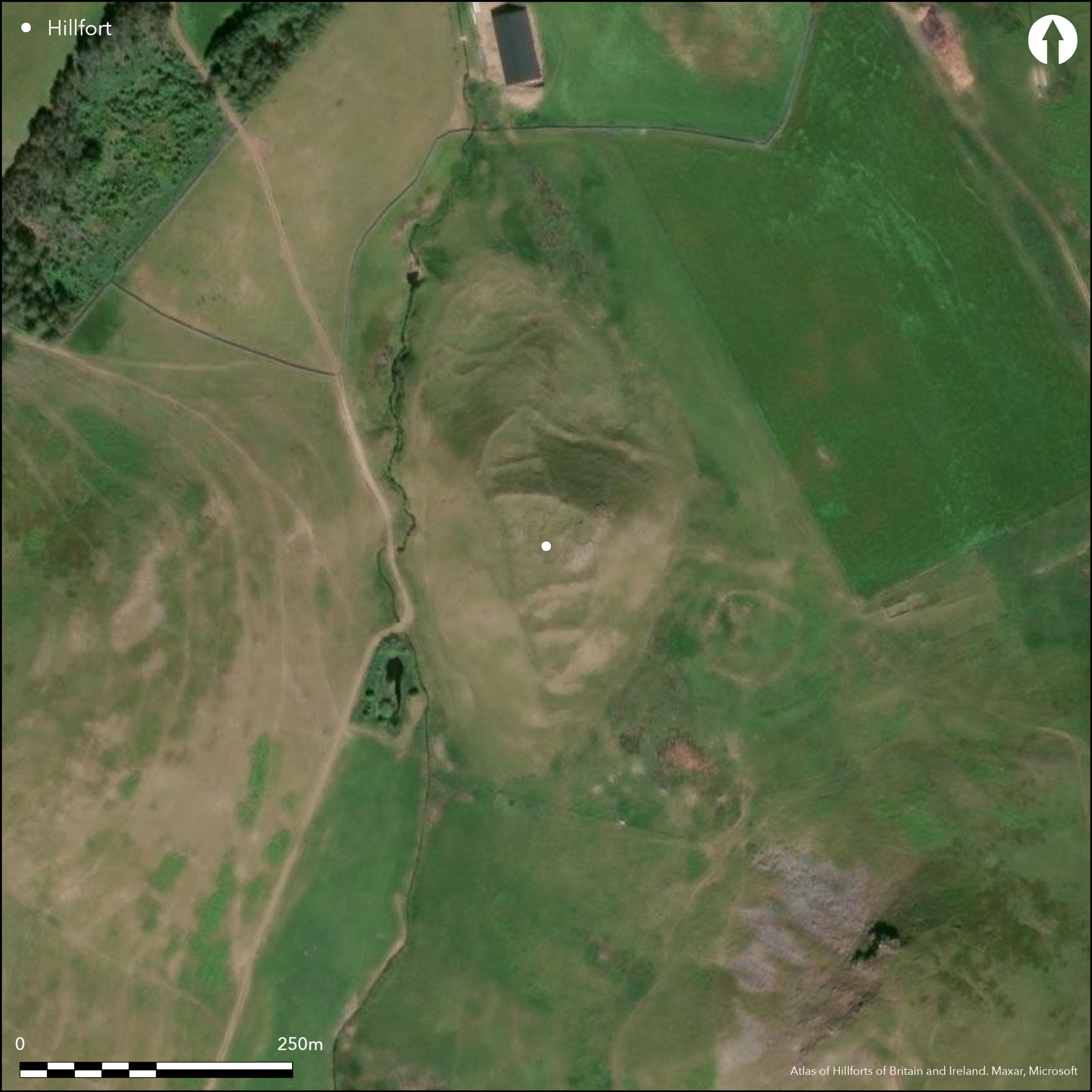
The Moat Knowe is a steep-sided hillock that rises sharply out of the floor of the valley SE of Buchtrig. It is occupied by a fortification that conforms to the character of a so-called nuclear fort, comprising a citadel with a series of outer courts. In the case of the Moat Knowe, the citadel and the courts appear to form a single conception, with a single wall running the length of the W side, not only forming one side of the citadel and each of the four courts, but flanking the upper ends of the entrance trackways that mount the slopes on the N and S respectively to curl in through entrances into the lowest court at each end. The citadel is roughly trapezoidal on plan, measuring a maximum of 50m from N to S by 45m transversely (0.2ha) within a wall up to 2.4m in thickness, and its interior steps down from the rocky summit on the E in four artificial terraces, which have probably provided the foundation for tiers of building; while the shape of the building is unclear on the ground, aerial photographs give a strong impression that some were rectangular. Two outer courts step down the slope to either side of the citadel, each party wall stopping short of the W side to allow access from the entrances up to the summit. The upper one on the S has several scooped platforms, while in the lower a line of stones separates the roadway from the rest of the court. By comparison the upper court on the N is much steeper and only has two small scoops on its lower side, while the outer below it is featureless. The entrances are arranged slightly differently to each other; whereas the terraced trackway on the N approaches the gap obliquely to expose the visitor's left side below the wall, on the S, where the approach is more direct, it is the visitor's right side that is exposed.
Citizen Science: ✗
Reliability of Data: Confirmed
Reliability of Interpretation: Confirmed
X: -261778 Y: 7443065 (EPSG: 3857)
Longitude: -2.351595785558673 Latitude: 55.41620394088096 (EPSG:4326)
Country: Scotland
Current County or Unitary Authority: Scottish Borders
Historic County: Roxburghshire
Current Parish/Community/Council/Townland: Hownam
None
Condition:| Extant | ✓ |
| Cropmark | ✗ |
| Likely Destroyed | ✗ |
None
Current Use:| Woodland | ✗ |
| Commercial Forestry Plantation | ✗ |
| Parkland | ✗ |
| Pasture (Grazing) | ✓ |
| Arable | ✗ |
| Scrub/Bracken | ✗ |
| Bare Outcrop | ✗ |
| Heather/Moorland | ✓ |
| Heath | ✗ |
| Built-up | ✗ |
| Coastal Grassland | ✗ |
| Other | ✗ |
None
Type:| Contour Fort | ✓ |
| Partial Contour Fort | ✗ |
| Promontory Fort | ✗ |
| Hillslope Fort | ✗ |
| Level Terrain Fort | ✗ |
| Marsh Fort | ✗ |
| Multiple Enclosure Fort | ✗ |
| Hilltop | ✗ |
| Coastal Promontory | ✗ |
| Inland Promontory | ✗ |
| Valley Bottom | ✗ |
| Knoll/Hillock/Outcrop | ✓ |
| Ridge | ✗ |
| Cliff/Plateau-edge/Scarp | ✗ |
| Hillslope | ✗ |
| Lowland | ✗ |
| Spur | ✗ |
Dominant Topographic Feature: None
| North | ✗ |
| Northeast | ✗ |
| East | ✗ |
| Southeast | ✗ |
| South | ✗ |
| Southwest | ✗ |
| West | ✗ |
| Northwest | ✗ |
| Level | ✓ |
Altitude: 305.0m
N/A
In so far as morphology can be used to identify early medieval fortifications, this is a nuclear fort, though in the absence of excavation there are neither stratified objects nor radiocarbon dates to confirm this interpretation.
Reliability: D - None
Principal Activity:| Pre 1200BC | ✗ |
| 1200BC - 800BC | ✗ |
| 800BC - 400BC | ✗ |
| 400BC - AD50 | ✗ |
| AD50 - AD400 | ✗ |
| AD400 - AD 800 | ✓ |
| Post AD800 | ✗ |
| Unknown | ✗ |
| Pre Hillfort: | None |
| Post Hillfort: | None |
| Morphology/Earthwork/Typology: | Nuclear fort |
Photographed by CUCAP in 1949, Dennis Harding in 1983 and RCAHMS Aerial Survey Programme in 1994, 2010 and 2013
| 1st Identified Map Depiction (1859): | Annotated Fort on the 1st edition OS 25-inch map (Roxburgh 1863, 28.7) |
| Other (1884): | Noted (Geikie 1884, 141) |
| Earthwork Survey (1946): | Plan and description (RCAHMS 1956, 167-9, no.307, fig 196; RXD 125/1-2) |
| Other (1960): | Visited by the OS |
| Other (1961): | Scheduled |
| Other (1973): | Visited by the OS |
| Other (1976): | Visited by the OS |
| Other (1999): | Description by RCAHMS |
The interior of the central enclosure descends in a series of rocky terraces on several of which there are traces of scoops and low banks that suggest the presence of rectangular buildings. In addition the most recent survey by RCAHMS identified a rectangular building in the lower court on the S, with possible traces of a second adjacent.
None
Source:| None | ✓ |
| Spring | ✗ |
| Stream | ✗ |
| Pool | ✗ |
| Flush | ✗ |
| Well | ✗ |
| Other | ✗ |
None
Interior Features (Surface):| No Known Features | ✗ |
| Round Stone Structures | ✗ |
| Rectangular Stone Structures | ✓ |
| Curvilinear Platforms | ✗ |
| Other Roundhouse Evidence | ✗ |
| Pits | ✗ |
| Quarry Hollows | ✗ |
| Other | ✗ |
None
Interior Features (Excavation):| No Known Excavation | ✓ |
| Pits | ✗ |
| Postholes | ✗ |
| Roundhouses | ✗ |
| Rectangular Structures | ✗ |
| Roads/Tracks | ✗ |
| Quarry Hollows | ✗ |
| Other | ✗ |
| Nothing Found | ✗ |
None
Interior Features (Geophysics):| No Known Geophysics | ✓ |
| Pits | ✗ |
| Roundhouses | ✗ |
| Rectangular Structures | ✗ |
| Roads/Tracks | ✗ |
| Quarry Hollows | ✗ |
| Other | ✗ |
| Nothing Found | ✗ |
None
Interior (Finds):| No Known Finds | ✓ |
| Pottery | ✗ |
| Metal | ✗ |
| Metalworking | ✗ |
| Human Bones | ✗ |
| Animal Bones | ✗ |
| Lithics | ✗ |
| Environmental | ✗ |
| Other | ✗ |
Showing as faint rectilinear of low banks and scarps
Interior Features (Aerial):| APs Not Checked | ✗ |
| None | ✗ |
| Roundhouses | ✗ |
| Rectangular Structures | ✓ |
| Pits | ✗ |
| Postholes | ✗ |
| Roads/Tracks | ✗ |
| Other | ✗ |
See main summary
Total Number of Breaks Through Ramparts:| 2: | None |
| 2: | None |
Guard Chambers: ✗
Chevaux de Frise: ✗
| 1. Oblique (North): | Oblique approach exposing left side |
| 1. Over-lapping (North): | None |
| 1. Hollow Way (North): | None |
| 2. Hornwork (South): | Oblique approach exposing right side |
Walls defining a series of courts with common sides
Enclosed Area:| Area 1: | 0.2ha. |
| Total: | 0.2ha. |
Total Footprint Area: 0.42ha.
None
Multi-period Enclosure System:| ✗ | None |
| ✓ | The defences do not lend themselves particularly well to the analysis by quadrant |
| NE Quadrant: | 1 |
| SE Quadrant: | 3 |
| SW Quadrant: | 1 |
| NW Quadrant: | 3 |
| Total: | 3 |
| Partial Univallate | ✓ |
| Univallate | ✗ |
| Partial Bivallate | ✗ |
| Bivallate | ✗ |
| Partial Multivallate | ✓ |
| Multivallate | ✗ |
| Unknown | ✗ |
| Partial Univallate | ✗ |
| Univallate | ✗ |
| Partial Bivallate | ✗ |
| Bivallate | ✗ |
| Partial Multivallate | ✗ |
| Multivallate | ✗ |
None
Enclosing Works (Surface):| None | ✗ |
| Earthen Bank | ✗ |
| Stone Wall | ✓ |
| Rubble | ✗ |
| Wall-walk | ✗ |
| Evidence of Timber | ✗ |
| Vitrification | ✗ |
| Other Burning | ✗ |
| Palisade | ✗ |
| Counter Scarp Bank | ✗ |
| Berm | ✗ |
| Unfinished | ✗ |
| Other | ✗ |
None
Enclosing Works (Excavation):| None | ✗ |
| Earthen Bank | ✗ |
| Stone Wall | ✗ |
| Murus Duplex | ✗ |
| Timber-framed | ✗ |
| Timber-laced | ✗ |
| Vitrification | ✗ |
| Other Burning | ✗ |
| Palisade | ✗ |
| Counter Scarp Bank | ✗ |
| Berm | ✗ |
| Unfinished | ✗ |
| No Known Excavation | ✓ |
| Other | ✗ |
| ✗ | None |
| ✗ | None |
Number of Ditches: None
Annex:| ✓ | As a nuclear fort, the organisation of the whole interior is into a series of mutually linked courts or annexes. |
Geikie, J (1884) «List of hill forts, intrenched camps, etc. in Roxburghshire on the Scotch side of the Cheviots». Hist Berwickshire Natur Club 10 (1882-4) 139-44
RCAHMS (1956) The Royal Commission on the Ancient and Historical Monuments of Scotland. An inventory of the ancient and historical monuments of Roxburghshire: with the fourteenth report of the Commission, 2v. HMSO: Edinburgh
This work is licensed under CC BY-SA 4.0![]()
![]()
![]() and should be cited as:
and should be cited as:
Lock, Gary and Ralston, Ian. 2024. Atlas of Hillforts of Britain and Ireland. Available at: https://hillforts.arch.ox.ac.uk
Document Version 1.1