Satellite Imagery
Satellite Imagery
HER: Scottish Borders 58083 (None)
NMR: NT 71 SE 29 (58083)
SM: 2167
NGR: NT 7681 1127
X: 376818 Y: 611271 (OSGB36)
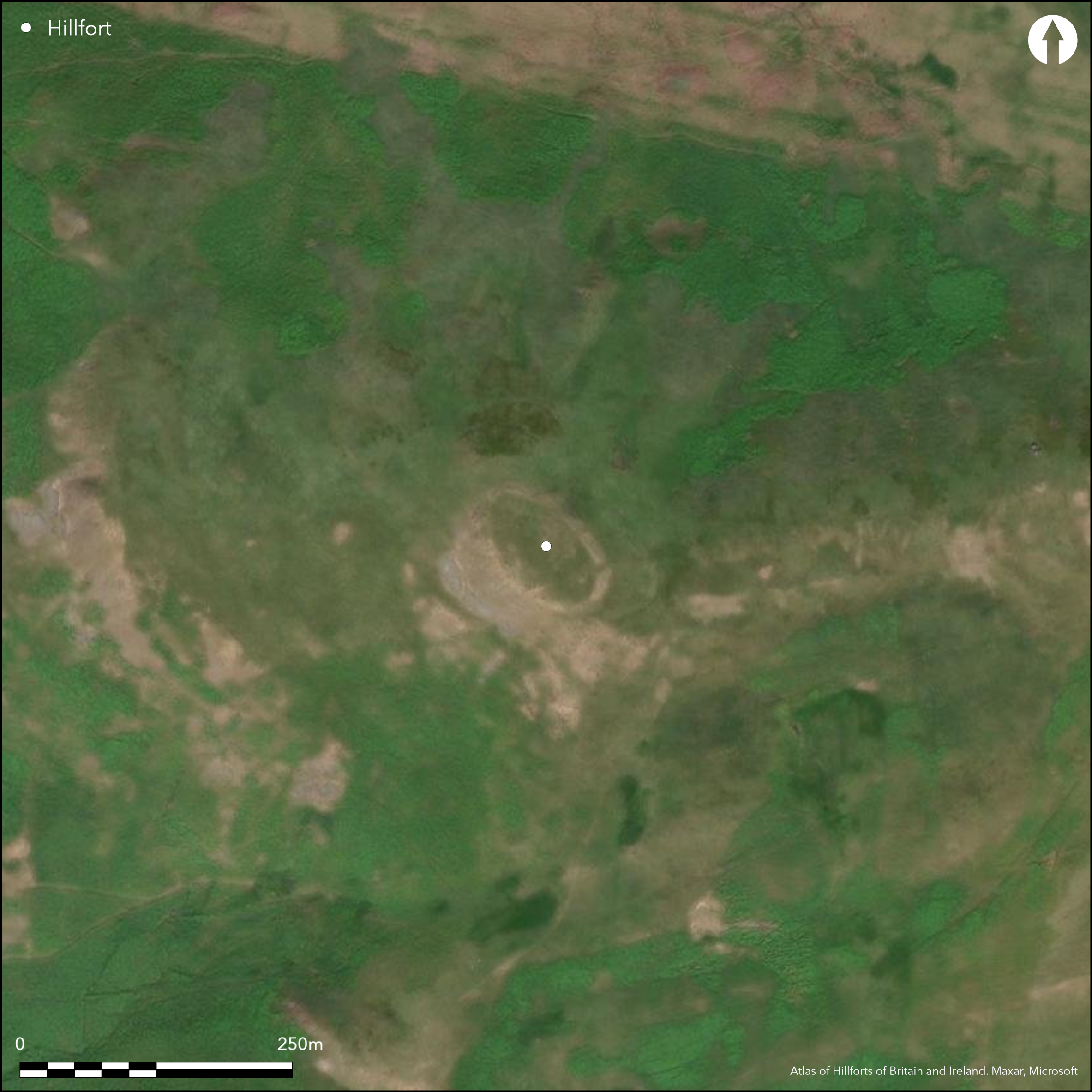
This fort is situated on the summit of Hindhope Hill, which forms the W end of a spur that runs up to the border line between Scotland and England on Blackhall Hill. Oval on plan, it measures 74m from NW to SE by 44m transversely (0.2ha) within a rampart about 3m thick, and there are entrances on the ESE and NW respectively. Some 20m to the E, blocking the easiest line of approach, an outer rampart and external ditch cut across the spine of the spur, returning back along the edges to either side; traces of the scarp on the northern flank can be traced on aerial photographs round to the NW end of the fort. Two gaps can be seen in the E arc of this outer enclosure, at either end of the segment of rampart, and either or both may be entrances. Within the interior of the inner enclosure up to six ring-ditch houses are visible. In addition to the fort, the outlying earthwork on the ESE overlies an earlier palisaded enclosure on the crest of the spur. Measuring about 31m square, it has a possible entrance on the E and there are traces of a single ring-ditch house within its interior.
Citizen Science: ✗
Reliability of Data: Confirmed
Reliability of Interpretation: Confirmed
X: -263554 Y: 7438883 (EPSG: 3857)
Longitude: -2.3675418529306236 Latitude: 55.394869701781644 (EPSG:4326)
Country: Scotland
Current County or Unitary Authority: Scottish Borders
Historic County: Roxburghshire
Current Parish/Community/Council/Townland: Oxnam
None
| Extant | ✓ |
| Cropmark | ✗ |
| Likely Destroyed | ✗ |
None
| Woodland | ✗ |
| Commercial Forestry Plantation | ✗ |
| Parkland | ✗ |
| Pasture (Grazing) | ✓ |
| Arable | ✗ |
| Scrub/Bracken | ✗ |
| Bare Outcrop | ✗ |
| Heather/Moorland | ✓ |
| Heath | ✗ |
| Built-up | ✗ |
| Coastal Grassland | ✗ |
| Other | ✗ |
None
| Contour Fort | ✓ |
| Partial Contour Fort | ✗ |
| Promontory Fort | ✗ |
| Hillslope Fort | ✗ |
| Level Terrain Fort | ✗ |
| Marsh Fort | ✗ |
| Multiple Enclosure Fort | ✗ |
| Hilltop | ✓ |
| Coastal Promontory | ✗ |
| Inland Promontory | ✗ |
| Valley Bottom | ✗ |
| Knoll/Hillock/Outcrop | ✗ |
| Ridge | ✗ |
| Cliff/Plateau-edge/Scarp | ✗ |
| Hillslope | ✗ |
| Lowland | ✗ |
| Spur | ✗ |
Dominant Topographic Feature: None
| North | ✗ |
| Northeast | ✗ |
| East | ✗ |
| Southeast | ✗ |
| South | ✗ |
| Southwest | ✗ |
| West | ✗ |
| Northwest | ✗ |
| Level | ✓ |
Altitude: 411.0m
N/A
In the absence of excavation, there are neither stratified artefacts nor radiocarbon dates to provide a chronology for the defences.
Reliability: D - None
| Pre 1200BC | ✗ |
| 1200BC - 800BC | ✗ |
| 800BC - 400BC | ✗ |
| 400BC - AD50 | ✗ |
| AD50 - AD400 | ✗ |
| AD400 - AD 800 | ✗ |
| Post AD800 | ✗ |
| Unknown | ✓ |
| Pre Hillfort: | None |
| Post Hillfort: | None |
Photographed by RAHMS Aerial Survey Programme in 1992, 2004 and 2010, and by John Dent in 1992.
| Earthwork Survey (1948): | Plan and description (RCAHMS 1956, 378, no.797, fig 487; RAHMS RXD 178/1-2) |
| 1st Identified Map Depiction (1960): | Visited by the OS |
| Other (1961): | Scheduled |
| Other (1973): | Visited by the OS |
| Other (1999): | Description by RCAHMS |
Up to six ring-ditch houses
None
| None | ✓ |
| Spring | ✗ |
| Stream | ✗ |
| Pool | ✗ |
| Flush | ✗ |
| Well | ✗ |
| Other | ✗ |
Ring-ditch houses
| No Known Features | ✗ |
| Round Stone Structures | ✗ |
| Rectangular Stone Structures | ✗ |
| Curvilinear Platforms | ✗ |
| Other Roundhouse Evidence | ✓ |
| Pits | ✗ |
| Quarry Hollows | ✗ |
| Other | ✗ |
None
| No Known Excavation | ✓ |
| Pits | ✗ |
| Postholes | ✗ |
| Roundhouses | ✗ |
| Rectangular Structures | ✗ |
| Roads/Tracks | ✗ |
| Quarry Hollows | ✗ |
| Other | ✗ |
| Nothing Found | ✗ |
None
| No Known Geophysics | ✓ |
| Pits | ✗ |
| Roundhouses | ✗ |
| Rectangular Structures | ✗ |
| Roads/Tracks | ✗ |
| Quarry Hollows | ✗ |
| Other | ✗ |
| Nothing Found | ✗ |
None
| No Known Finds | ✓ |
| Pottery | ✗ |
| Metal | ✗ |
| Metalworking | ✗ |
| Human Bones | ✗ |
| Animal Bones | ✗ |
| Lithics | ✗ |
| Environmental | ✗ |
| Other | ✗ |
None
| APs Not Checked | ✗ |
| None | ✗ |
| Roundhouses | ✓ |
| Rectangular Structures | ✗ |
| Pits | ✗ |
| Postholes | ✗ |
| Roads/Tracks | ✗ |
| Other | ✗ |
See main summary
| 2: | None |
| 2: | In addition there are two gaps in the outwork on the E |
Guard Chambers: ✗
Chevaux de Frise: ✗
| 1. Simple Gap (East): | None |
| 2. Simple Gap (North west): | None |
Inner enclosure on the summit with an outlying earthwork across the more vulnerable sides
| Area 1: | 0.2ha. |
| Total: | 0.2ha. |
Total Footprint Area: 0.56ha.
None
| ✓ | The outer defences overlie a rectangular palisaded enclosure on the ESE |
| ✓ | None |
| NE Quadrant: | 2 |
| SE Quadrant: | 2 |
| SW Quadrant: | 1 |
| NW Quadrant: | 1 |
| Total: | 2 |
| Partial Univallate | ✓ |
| Univallate | ✗ |
| Partial Bivallate | ✓ |
| Bivallate | ✗ |
| Partial Multivallate | ✗ |
| Multivallate | ✗ |
| Unknown | ✗ |
| Partial Univallate | ✗ |
| Univallate | ✗ |
| Partial Bivallate | ✗ |
| Bivallate | ✗ |
| Partial Multivallate | ✗ |
| Multivallate | ✗ |
None
| None | ✗ |
| Earthen Bank | ✓ |
| Stone Wall | ✓ |
| Rubble | ✗ |
| Wall-walk | ✗ |
| Evidence of Timber | ✗ |
| Vitrification | ✗ |
| Other Burning | ✗ |
| Palisade | ✓ |
| Counter Scarp Bank | ✗ |
| Berm | ✗ |
| Unfinished | ✗ |
| Other | ✗ |
None
| None | ✗ |
| Earthen Bank | ✗ |
| Stone Wall | ✗ |
| Murus Duplex | ✗ |
| Timber-framed | ✗ |
| Timber-laced | ✗ |
| Vitrification | ✗ |
| Other Burning | ✗ |
| Palisade | ✗ |
| Counter Scarp Bank | ✗ |
| Berm | ✗ |
| Unfinished | ✗ |
| No Known Excavation | ✓ |
| Other | ✗ |
| ✗ | None |
| ✓ | The outlying rampart |
Number of Ditches: 1
| ✓ | The outlying rampart might be construed as some form of annexe, despite not forming a coherent enclosure |
RCAHMS (1956) The Royal Commission on the Ancient and Historical Monuments of Scotland. An inventory of the ancient and historical monuments of Roxburghshire: with the fourteenth report of the Commission, 2v. HMSO: Edinburgh
Atlas of Hillforts:
Wikidata:
This work is licensed under CC BY-SA 4.0![]()
![]()
![]() and should be cited as:
and should be cited as:
Lock, Gary and Ralston, Ian. 2024. Atlas of Hillforts of Britain and Ireland. Available at: https://hillforts.arch.ox.ac.uk
Document Version 1.1