Satellite Imagery
Satellite Imagery
HER: Scottish Borders 58271 (None)
NMR: NT 72 SE 10 (58271)
SM: 298
NGR: NT 7964 2200
X: 379640 Y: 622000 (OSGB36)
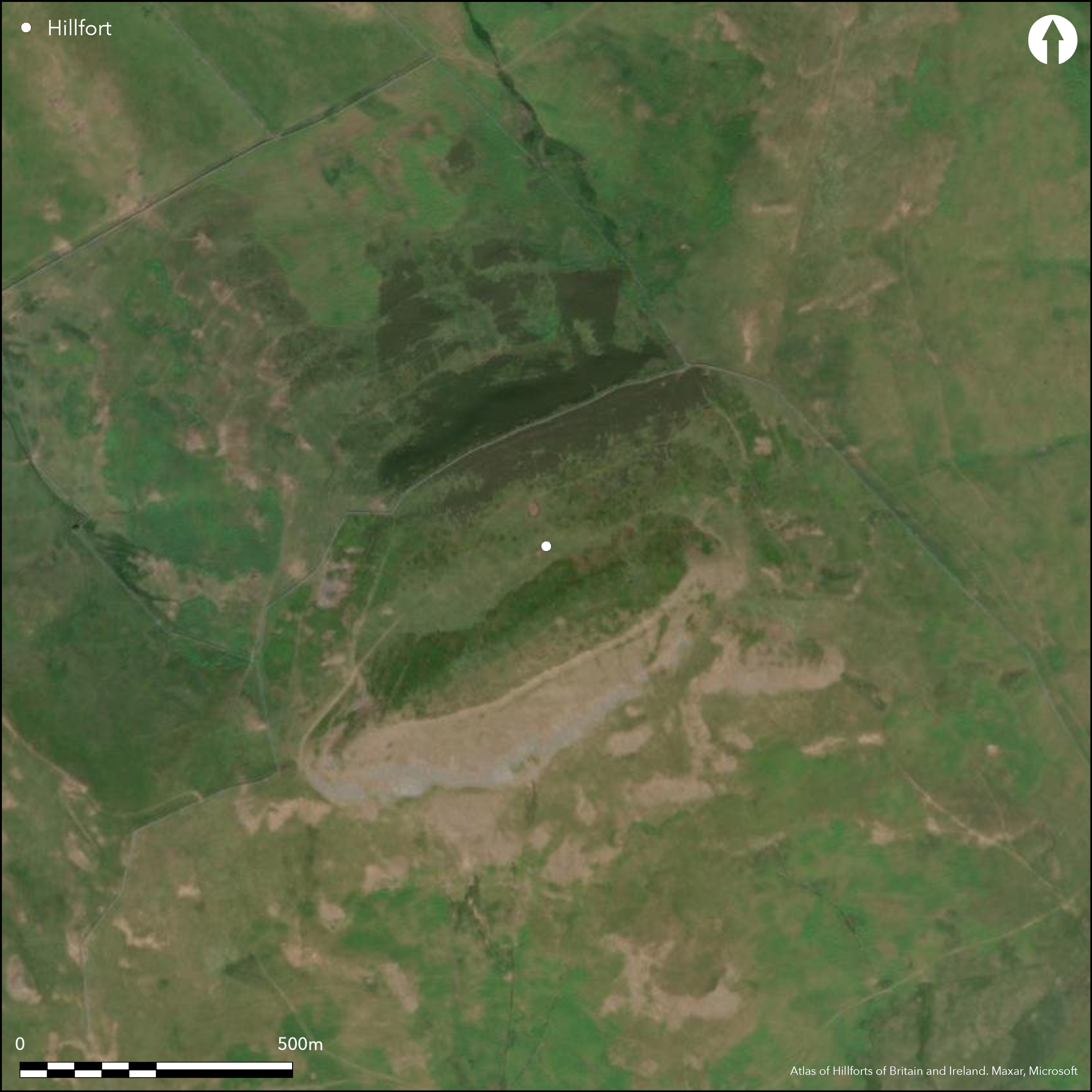
The fort crowning Hownam Law, which is a prominent summit on the northern flank of the Cheviots, is one of the larger around the Tweed basin, enclosing about 8.8ha and second only in size to Eildon Hill North. The single rampart, which has stone faces and measures about 3m in thickness, follows natural shoulders from which the ground drops away steeply on all sides, extending along the SSE flank of the summit ridge before dropping down to take in a lower terrace on the NNW flank. Topographically defined in this way, the plan is irregular and the interior measures a maximum of 490m from NE to SW by 238m transversely. A single entrance is visible at the SW end, piercing the rampart at the foot of the summit ridge, and the plan drawn up by RCAHMS investigators places a second, unremarked, at the NE apex; they failed to locate an entrance noted in 1929 by James Hewat Craw in a re-entrant created by a natural hollow on the E flank of the fort and dismissed a second gap in the SSE side as a relatively recent breach. Within the interior there are numerous traces of timber round-houses, ranging from shallow circular depressions to well-defined platforms, but counts vary; a plan by Roger Mercer prepared in 1985 (RCAHMS DC48788) shows about 110, whereas the RCAHMS investigators identified 155 and James Hewat Craw 187 (1931, 219), which perhaps accounts for why the RCAHMS investigators speculated that many more might be hidden beneath the heather and coarse grass, a contention that is broadly supported by oblique aerial photographs taken under a range of conditions since. The interior is also unusual for the two artificial ponds measuring 15m and 13m in diameter respectively, which a have been dug on the lower terrace close to the centre. The only other feature of note is a a later enclosure which overlies the rampart on the NE, taking in an oval area measuring 75m from NW to SE by 70m transversely; the perimeter comprises a bank 3m to 4.5m in thickness by 0.7m in height with an external ditch up to 2.4m in breadth and is broken by an entrance in its N side.
Citizen Science: ✗
Reliability of Data: Confirmed
Reliability of Interpretation: Confirmed
X: -258682 Y: 7457827 (EPSG: 3857)
Longitude: -2.3237772564050423 Latitude: 55.49140133875371 (EPSG:4326)
Country: Scotland
Current County or Unitary Authority: Scottish Borders
Historic County: Roxburghshire
Current Parish/Community/Council/Townland: Hownam
None
| Extant | ✓ |
| Cropmark | ✗ |
| Likely Destroyed | ✗ |
None
| Woodland | ✗ |
| Commercial Forestry Plantation | ✗ |
| Parkland | ✗ |
| Pasture (Grazing) | ✓ |
| Arable | ✗ |
| Scrub/Bracken | ✗ |
| Bare Outcrop | ✗ |
| Heather/Moorland | ✓ |
| Heath | ✗ |
| Built-up | ✗ |
| Coastal Grassland | ✗ |
| Other | ✗ |
None
| Contour Fort | ✗ |
| Partial Contour Fort | ✓ |
| Promontory Fort | ✗ |
| Hillslope Fort | ✗ |
| Level Terrain Fort | ✗ |
| Marsh Fort | ✗ |
| Multiple Enclosure Fort | ✗ |
| Hilltop | ✓ |
| Coastal Promontory | ✗ |
| Inland Promontory | ✗ |
| Valley Bottom | ✗ |
| Knoll/Hillock/Outcrop | ✗ |
| Ridge | ✗ |
| Cliff/Plateau-edge/Scarp | ✗ |
| Hillslope | ✗ |
| Lowland | ✗ |
| Spur | ✗ |
Dominant Topographic Feature: A prominent outlying summit of the Cheviots
| North | ✗ |
| Northeast | ✗ |
| East | ✗ |
| Southeast | ✗ |
| South | ✗ |
| Southwest | ✗ |
| West | ✗ |
| Northwest | ✗ |
| Level | ✓ |
Altitude: 449.0m
N/A
In the absence of excavation, there are neither stratified artefacts nor radiocarbon dates to provide a chronology for the defences.
Reliability: D - None
| Pre 1200BC | ✗ |
| 1200BC - 800BC | ✗ |
| 800BC - 400BC | ✗ |
| 400BC - AD50 | ✗ |
| AD50 - AD400 | ✗ |
| AD400 - AD 800 | ✗ |
| Post AD800 | ✗ |
| Unknown | ✓ |
| Pre Hillfort: | The summit is marked by a cairn |
| Post Hillfort: | The rampart is overlain by an old stone dyke |
Appears in David Christison's table of forts above 1200 ft OD (1898, 124, 290), but there is nothing to suggest he visited it. It has been photographed from the air by Dennis Harding in 1982 and 1983, CUCAP in 1948 and 1949, and RCAHMS Aerial Survey Programme in 1988, 1993, 2004 and 2010
| 1st Identified Written Reference (1791): | Noted (Stat Acct, i, 1791, 52) |
| 1st Identified Map Depiction (1859): | Annotated Camp in Roman Type on the 1st edition OS 25-inch map (Roxburgh 1863, sheet 22.3) |
| Earthwork Survey (1929): | Plan and description (Craw 1931) |
| Earthwork Survey (1949): | Plan and description (RCAHMS 1956, 157-9, no.299, fig 185; RCAHMS RXD 117/1-5) |
| Other (1958): | Scheduled |
| Other (1968): | Resurveyed at 1:2500 by the OS |
| Earthwork Survey (1985): | Plan and description by Roger Mercer (RCAHMS DC15959-65, DC48745 & DC48788); the north point has been reversed and misaligned on DC48788. |
At least 155 round-house stances
None
| None | ✗ |
| Spring | ✗ |
| Stream | ✗ |
| Pool | ✓ |
| Flush | ✗ |
| Well | ✗ |
| Other | ✗ |
None
| No Known Features | ✗ |
| Round Stone Structures | ✗ |
| Rectangular Stone Structures | ✗ |
| Curvilinear Platforms | ✓ |
| Other Roundhouse Evidence | ✓ |
| Pits | ✗ |
| Quarry Hollows | ✗ |
| Other | ✗ |
None
| No Known Excavation | ✓ |
| Pits | ✗ |
| Postholes | ✗ |
| Roundhouses | ✗ |
| Rectangular Structures | ✗ |
| Roads/Tracks | ✗ |
| Quarry Hollows | ✗ |
| Other | ✗ |
| Nothing Found | ✗ |
None
| No Known Geophysics | ✓ |
| Pits | ✗ |
| Roundhouses | ✗ |
| Rectangular Structures | ✗ |
| Roads/Tracks | ✗ |
| Quarry Hollows | ✗ |
| Other | ✗ |
| Nothing Found | ✗ |
None
| No Known Finds | ✓ |
| Pottery | ✗ |
| Metal | ✗ |
| Metalworking | ✗ |
| Human Bones | ✗ |
| Animal Bones | ✗ |
| Lithics | ✗ |
| Environmental | ✗ |
| Other | ✗ |
NO APPARENT FEATURES
| APs Not Checked | ✗ |
| None | ✗ |
| Roundhouses | ✓ |
| Rectangular Structures | ✗ |
| Pits | ✗ |
| Postholes | ✗ |
| Roads/Tracks | ✗ |
| Other | ✗ |
See main summary
| 3: | None |
| 2: | None |
Guard Chambers: ✗
Chevaux de Frise: ✗
| 1. Simple Gap (South west): | None |
| 2. Simple Gap (North east): | None |
Single rampart
| Area 1: | 8.8ha. |
| Total: | 8.8ha. |
Total Footprint Area: Noneha.
None
| ✓ | Overlain by a smaller enclosure on the NE |
| ✓ | None |
| NE Quadrant: | 1 |
| SE Quadrant: | 1 |
| SW Quadrant: | 1 |
| NW Quadrant: | 1 |
| Total: | 1 |
| Partial Univallate | ✗ |
| Univallate | ✓ |
| Partial Bivallate | ✗ |
| Bivallate | ✗ |
| Partial Multivallate | ✗ |
| Multivallate | ✗ |
| Unknown | ✗ |
| Partial Univallate | ✗ |
| Univallate | ✗ |
| Partial Bivallate | ✗ |
| Bivallate | ✗ |
| Partial Multivallate | ✗ |
| Multivallate | ✗ |
None
| None | ✗ |
| Earthen Bank | ✗ |
| Stone Wall | ✓ |
| Rubble | ✗ |
| Wall-walk | ✗ |
| Evidence of Timber | ✗ |
| Vitrification | ✗ |
| Other Burning | ✗ |
| Palisade | ✗ |
| Counter Scarp Bank | ✗ |
| Berm | ✗ |
| Unfinished | ✗ |
| Other | ✗ |
None
| None | ✗ |
| Earthen Bank | ✗ |
| Stone Wall | ✗ |
| Murus Duplex | ✗ |
| Timber-framed | ✗ |
| Timber-laced | ✗ |
| Vitrification | ✗ |
| Other Burning | ✗ |
| Palisade | ✗ |
| Counter Scarp Bank | ✗ |
| Berm | ✗ |
| Unfinished | ✗ |
| No Known Excavation | ✓ |
| Other | ✗ |
| ✗ | None |
| ✗ | None |
Number of Ditches: None
| ✗ | None |
Christison, D (1898) Early fortifications in Scotland: motes, camps and forts: the Rhind lectures in archaeology for 1894. Blackwood & Sons: Edinburgh
Craw, J H (1931) 'Hounam Law fort'. Hist Berwickshire Natur Club 27 (1929-31), 218-20
RCAHMS (1956) The Royal Commission on the Ancient and Historical Monuments of Scotland. An inventory of the ancient and historical monuments of Roxburghshire: with the fourteenth report of the Commission, 2v. HMSO: Edinburgh
Atlas of Hillforts:
Wikidata:
This work is licensed under CC BY-SA 4.0![]()
![]()
![]() and should be cited as:
and should be cited as:
Lock, Gary and Ralston, Ian. 2024. Atlas of Hillforts of Britain and Ireland. Available at: https://hillforts.arch.ox.ac.uk
Document Version 1.1