Satellite Imagery
Satellite Imagery
HER: Scottish Borders 59026 (None)
NMR: NT 81 NE 8 (59026)
SM: 2106
NGR: NT 8602 1801
X: 386022 Y: 618019 (OSGB36)
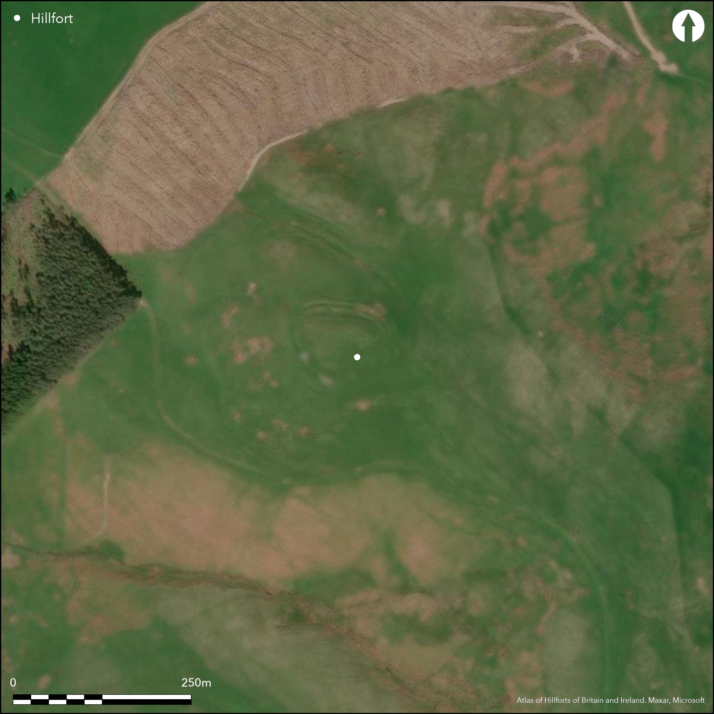
This small fort occupies a hillock forming the summit of the long spur dropping down from White Knowe above Hayhope Knowe. The defences comprise three ramparts and ditches, which step down the steep N flank of the hillock and swing round onto the E before disappearing beneath an area of cultivation, but at an entrance on the WNW the innermost and medial rampart contract into a single line and there are only two on the SW; there are also traces of a counterscarp bank on the N. Whether this contraction of the defences on the W and SW was part of the original design of a multivallate scheme, or whether it indicates several periods of modification and rebuilding is unclear, but it is difficult to sustain Roger Mercer's suggestion in 1986 that the inner rampart was a primary defence to which the outer ramparts were subsequently added. The D-shaped interior of the fort, measuring 61m from E to W by 47m transversely (0.02ha), is packed with traces of timber round-houses representing several periods of construction. At least twelve can be seen, comprising shallow ring-ditches, platforms encircled by shallow grooves, and simple platforms, and several have a pit in the centre, which in 1949 RCAHMS investigators identified as possible hearths. The round-houses are broadly disposed in two lines, though whether this is an accident of the sloping topography or about access from an axial 'street' is unclear. The only other features visible within the interior is a faint hollow immediately to the rear of the rampart on the N, but a trial excavation in 1949 by RCAHMS investigators revealed that it was no more than a shallow quarry behind the rampart. Surrounding the fort there are extensive traces of cultivation, including cord rig, which extends right up to the foot of the defences on the N, where Mercer suggested it might be overlain by the possible counterscarp bank; the relationship remains untested.
Citizen Science: ✗
Reliability of Data: Confirmed
Reliability of Interpretation: Confirmed
X: -247416 Y: 7450846 (EPSG: 3857)
Longitude: -2.2225713802398195 Latitude: 55.45585516893077 (EPSG:4326)
Country: Scotland
Current County or Unitary Authority: Scottish Borders
Historic County: Roxburghshire
Current Parish/Community/Council/Townland: Morebattle
None
| Extant | ✓ |
| Cropmark | ✗ |
| Likely Destroyed | ✗ |
None
| Woodland | ✗ |
| Commercial Forestry Plantation | ✗ |
| Parkland | ✗ |
| Pasture (Grazing) | ✓ |
| Arable | ✗ |
| Scrub/Bracken | ✗ |
| Bare Outcrop | ✗ |
| Heather/Moorland | ✓ |
| Heath | ✗ |
| Built-up | ✗ |
| Coastal Grassland | ✗ |
| Other | ✗ |
None
| Contour Fort | ✓ |
| Partial Contour Fort | ✗ |
| Promontory Fort | ✗ |
| Hillslope Fort | ✗ |
| Level Terrain Fort | ✗ |
| Marsh Fort | ✗ |
| Multiple Enclosure Fort | ✗ |
| Hilltop | ✓ |
| Coastal Promontory | ✗ |
| Inland Promontory | ✗ |
| Valley Bottom | ✗ |
| Knoll/Hillock/Outcrop | ✗ |
| Ridge | ✗ |
| Cliff/Plateau-edge/Scarp | ✗ |
| Hillslope | ✗ |
| Lowland | ✗ |
| Spur | ✗ |
Dominant Topographic Feature: None
| North | ✗ |
| Northeast | ✗ |
| East | ✗ |
| Southeast | ✗ |
| South | ✗ |
| Southwest | ✗ |
| West | ✗ |
| Northwest | ✗ |
| Level | ✓ |
Altitude: 372.0m
N/A
In the absence of excavation, there are neither stratified artefacts nor radiocarbon dates to provide a chronology for the defences.
Reliability: D - None
| Pre 1200BC | ✗ |
| 1200BC - 800BC | ✗ |
| 800BC - 400BC | ✗ |
| 400BC - AD50 | ✗ |
| AD50 - AD400 | ✗ |
| AD400 - AD 800 | ✗ |
| Post AD800 | ✗ |
| Unknown | ✓ |
| Pre Hillfort: | None |
| Post Hillfort: | Ramparts ploughed down on the SE during the post-medievalperiod |
Aerial photography has been taken under varying conditions, including by CUCAP in 1945, 1970 and 1997, Dennis Harding in 1982 and 1983, John Dent in 1992, and by RCAHMS Aerial Survey Programme in 1994 and 2010.
| 1st Identified Map Depiction (1755): | Depicted on William Roy's Military Map of Scotland (1747-55) |
| Other (1859): | Annotated Camp on the 1st edition OS 25-inch map (Roxburghshire 1863, sheet 23) |
| Other (1884): | Noted (Geikie 1884, 142) |
| Other (1897): | Noted by Francis Lynn (1898, 193) |
| Earthwork Survey (1949): | Plan and description (RCAHMS 1956, 336-7, no.653, fig 441; RCAHMS RXD 156/1-2) |
| Other (1949): | RCAHMS investigators dig a trench across a hollow behing the rampart on the N (RCAHMS 1956, 337) |
| Other (1960): | Visited by the OS |
| Other (1961): | Scheduled |
| Other (1968): | Visited by the OS |
| Other (1973): | Visited by the OS |
| Other (1976): | Visited by the OS |
| Earthwork Survey (1986): | Plan and description by Roger Mercer (RCAHMS DC16020-21, DC16034-7, DC16069, DC16433, DC16086; DC48821 & DP100556; Gazetteer MS2598) |
| Other (1987): | Camp Tops |
| Other (1994): | Re-Scheduled |
At least twelve timber round-house stances are visible within the interior, displaying a remarkable range of character from shallow ring-ditches to platforms with encircling grooves, in several cases with a pit visible at the centre
None
| None | ✓ |
| Spring | ✗ |
| Stream | ✗ |
| Pool | ✗ |
| Flush | ✗ |
| Well | ✗ |
| Other | ✗ |
Ring-ditch houses and platforms within ring-grooves
| No Known Features | ✗ |
| Round Stone Structures | ✗ |
| Rectangular Stone Structures | ✗ |
| Curvilinear Platforms | ✓ |
| Other Roundhouse Evidence | ✓ |
| Pits | ✗ |
| Quarry Hollows | ✗ |
| Other | ✗ |
None
| No Known Excavation | ✓ |
| Pits | ✗ |
| Postholes | ✗ |
| Roundhouses | ✗ |
| Rectangular Structures | ✗ |
| Roads/Tracks | ✗ |
| Quarry Hollows | ✗ |
| Other | ✗ |
| Nothing Found | ✗ |
None
| No Known Geophysics | ✓ |
| Pits | ✗ |
| Roundhouses | ✗ |
| Rectangular Structures | ✗ |
| Roads/Tracks | ✗ |
| Quarry Hollows | ✗ |
| Other | ✗ |
| Nothing Found | ✗ |
Found in a trial trench dug by RCAHMS investigators immediately to the rear of the rampart on the N
| No Known Finds | ✗ |
| Pottery | ✓ |
| Metal | ✗ |
| Metalworking | ✗ |
| Human Bones | ✗ |
| Animal Bones | ✗ |
| Lithics | ✗ |
| Environmental | ✗ |
| Other | ✗ |
None
| APs Not Checked | ✗ |
| None | ✗ |
| Roundhouses | ✓ |
| Rectangular Structures | ✗ |
| Pits | ✗ |
| Postholes | ✗ |
| Roads/Tracks | ✗ |
| Other | ✗ |
See main summary
| 3: | A small quarry has been cut though the ramparts on the SW |
| 2: | None |
Guard Chambers: ✗
Chevaux de Frise: ✗
| 1. Simple Gap (East): | Through all three ramparts |
| 2. Simple Gap (West): | Through all ramparts at the junction between the double and tripple defence |
Three ramparts and ditches around the N half of the circuit and two around the S half
| Area 1: | 0.2ha. |
| Total: | 0.2ha. |
Total Footprint Area: Noneha.
None
| ✗ | None |
| ✓ | None |
| NE Quadrant: | 3 |
| SE Quadrant: | 2 |
| SW Quadrant: | 2 |
| NW Quadrant: | 3 |
| Total: | 3 |
| Partial Univallate | ✗ |
| Univallate | ✗ |
| Partial Bivallate | ✓ |
| Bivallate | ✗ |
| Partial Multivallate | ✓ |
| Multivallate | ✗ |
| Unknown | ✗ |
| Partial Univallate | ✗ |
| Univallate | ✗ |
| Partial Bivallate | ✗ |
| Bivallate | ✗ |
| Partial Multivallate | ✗ |
| Multivallate | ✗ |
None
| None | ✗ |
| Earthen Bank | ✗ |
| Stone Wall | ✓ |
| Rubble | ✗ |
| Wall-walk | ✗ |
| Evidence of Timber | ✗ |
| Vitrification | ✗ |
| Other Burning | ✗ |
| Palisade | ✗ |
| Counter Scarp Bank | ✓ |
| Berm | ✗ |
| Unfinished | ✗ |
| Other | ✗ |
None
| None | ✗ |
| Earthen Bank | ✗ |
| Stone Wall | ✗ |
| Murus Duplex | ✗ |
| Timber-framed | ✗ |
| Timber-laced | ✗ |
| Vitrification | ✗ |
| Other Burning | ✗ |
| Palisade | ✗ |
| Counter Scarp Bank | ✗ |
| Berm | ✗ |
| Unfinished | ✗ |
| No Known Excavation | ✓ |
| Other | ✗ |
| ✗ | None |
| ✓ | None |
Number of Ditches: 3
| ✗ | None |
Geikie, J (1884) «List of hill forts, intrenched camps, etc. in Roxburghshire on the Scotch side of the Cheviots». Hist Berwickshire Natur Club 10 (1882-4) 139-44
Lynn, F (1898) 'The heads of Bowmont Water'. Hist Berwickshire Natur Club 16 (1896-8), 185-200
RCAHMS (1956) The Royal Commission on the Ancient and Historical Monuments of Scotland. An inventory of the ancient and historical monuments of Roxburghshire: with the fourteenth report of the Commission, 2v. HMSO: Edinburgh
Atlas of Hillforts:
Wikidata:
This work is licensed under CC BY-SA 4.0![]()
![]()
![]() and should be cited as:
and should be cited as:
Lock, Gary and Ralston, Ian. 2024. Atlas of Hillforts of Britain and Ireland. Available at: https://hillforts.arch.ox.ac.uk
Document Version 1.1