Satellite Imagery
Satellite Imagery
HER: Scottish Borders 59085 (None)
NMR: NT 81 NW 6 (59085)
SM: 2156
NGR: NT 8110 1907
X: 381100 Y: 619070 (OSGB36)
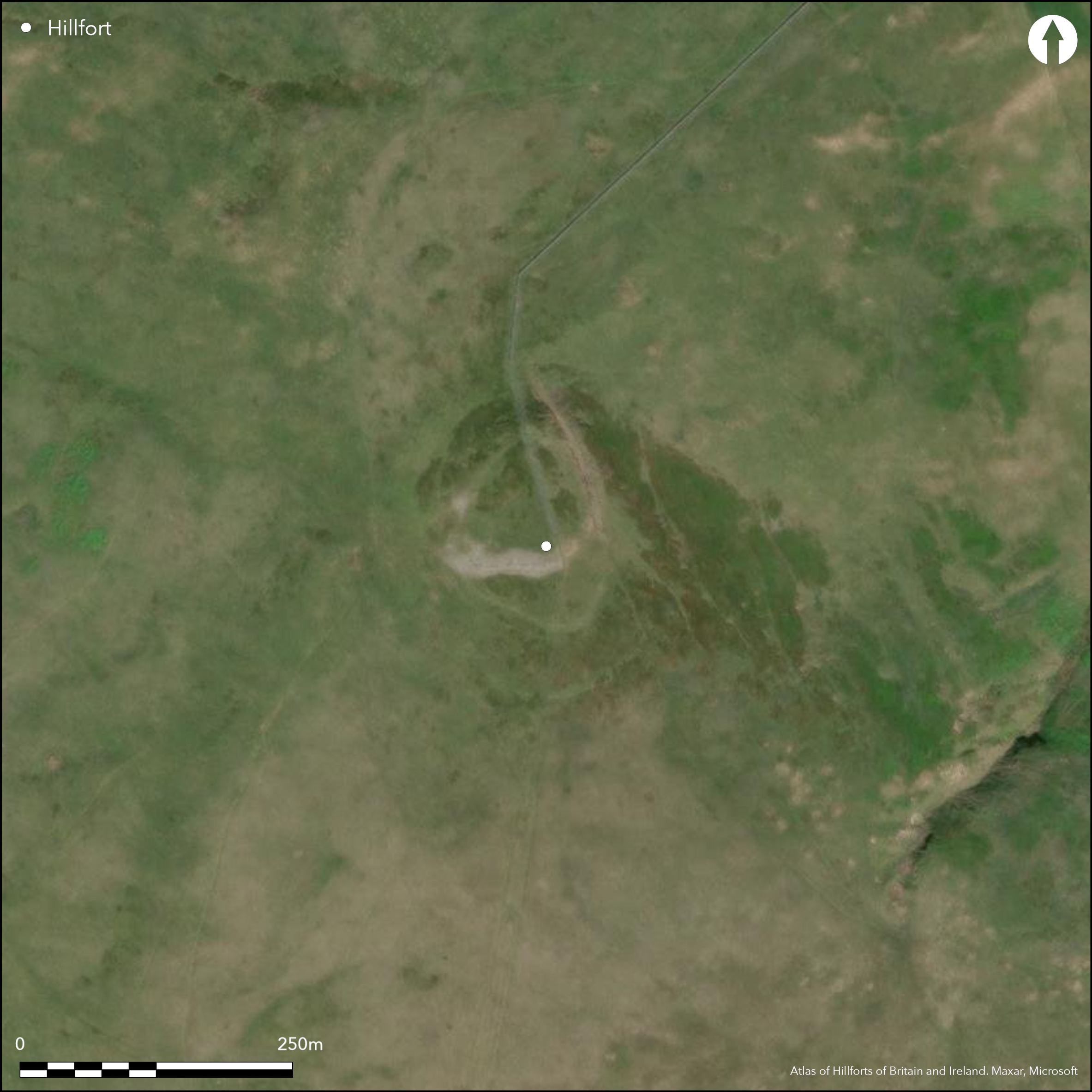
The fort on the summit of Craik Moor is not only one of the highest in Scotland, but also has the most complex arrangements of timber built perimeters of any fort yet recorded. Its defences comprise a wall that has probably succeeded a robbed rampart and a series of earlier and more extensive palisaded perimeters, though the precise sequence and the configuration of these timber defences is uncertain. While RCAHMS investigators who first recorded the defences in detail in 1949 believed that the inner wall formed a complete circuit, Roger Mercer in 1985 suggested that this, the latest period of fortification was effectively a promontory fort, with a stone-faced wall from 2.4m to 3.6m thick barring access to the summit from the S. If so, the interior is roughly triangular, measuring 63m in breadth immediately to the rear of the wall, and tapering northwards over a distance of at least 65m to the line of the earlier rampart (0.3ha), and possibly as much as 75m to the very tip of the summit area (0.37ha). In addition to several small scoops, it contains at least four large timber round-houses, two of which have clearly defined ring-ditches with well-formed entrances. Some of these round-houses, however, may belong to earlier phases and traces of another three are visible immediately outside the wall on the S, enclosed behind the next line of defence, a low bank with boulders protruding along its line. The RCAHMS investigators were puzzled by the character of this bank, suggesting that it perhaps supported a substantial palisade, accompanied by a roughly concentric palisade trench lying on the slope 8m outside its line. Mercer more reasonably suggests that this is the footing of a robbed rampart, and it is this rampart that once encircled the whole of the summit area, rather than the inner wall. Thus it forms a roughly oval enclosure measuring about 100m from N to S by 70m transversely (0.5ha), with an entrance on the E, adjacent to where the modern track was driven up onto the crest of the hill in 1987, slicing obliquely along the rampart. While this was possibly a composite defence of a rampart with an external palisade, on the E the palisade trench diverges from its line, possibly indicating that it was a separate enclosure, perhaps enclosing a slightly larger area of about 0.6ha. Apparently springing from a single hairpin terminal immediately outside this palisade on the W is a double palisade, with yet another palisade trench set concentrically some 10m outside it. This again gives the impression of a composite defence, with a timber rampart founded on the double palisade and a pale outside it. As this enclosure survives to us, it gives the impression of an attached annexe, adding a further 0.3ha, but this partly rests on the hairpin terminal, indicative of an entrance, and as Mercer suggests, if this is discounted, these palisades might equally well relate to a free-standing enclosure taking in the whole of the summit knoll and the lower slope to the S, enclosing an overall area of about 0.9ha. Within the 'annexe', Mercer noted traces of two more palisade trenches cutting across this side of the hill on slightly different lines, both almost certainly cut by the innermost of the palisades outside the robbed rampart, while aerial photographs show the footprints of at least four more timber round-houses; these, however, are very difficult to see on the ground on account of the traces of cultivation across this slope that are also revealed by the photographs and has been carried right up to the line of the inner wall.
Citizen Science: ✗
Reliability of Data: Confirmed
Reliability of Interpretation: Confirmed
X: -256087 Y: 7452667 (EPSG: 3857)
Longitude: -2.300470446595625 Latitude: 55.465132710025856 (EPSG:4326)
Country: Scotland
Current County or Unitary Authority: Scottish Borders
Historic County: Roxburghshire
Current Parish/Community/Council/Townland: Morebattle
None
| Extant | ✓ |
| Cropmark | ✗ |
| Likely Destroyed | ✗ |
None
| Woodland | ✗ |
| Commercial Forestry Plantation | ✗ |
| Parkland | ✗ |
| Pasture (Grazing) | ✓ |
| Arable | ✗ |
| Scrub/Bracken | ✗ |
| Bare Outcrop | ✗ |
| Heather/Moorland | ✓ |
| Heath | ✗ |
| Built-up | ✗ |
| Coastal Grassland | ✗ |
| Other | ✗ |
None
| Contour Fort | ✓ |
| Partial Contour Fort | ✗ |
| Promontory Fort | ✓ |
| Hillslope Fort | ✗ |
| Level Terrain Fort | ✗ |
| Marsh Fort | ✗ |
| Multiple Enclosure Fort | ✗ |
| Hilltop | ✓ |
| Coastal Promontory | ✗ |
| Inland Promontory | ✓ |
| Valley Bottom | ✗ |
| Knoll/Hillock/Outcrop | ✗ |
| Ridge | ✗ |
| Cliff/Plateau-edge/Scarp | ✗ |
| Hillslope | ✗ |
| Lowland | ✗ |
| Spur | ✗ |
Dominant Topographic Feature: None
| North | ✗ |
| Northeast | ✗ |
| East | ✗ |
| Southeast | ✗ |
| South | ✗ |
| Southwest | ✗ |
| West | ✗ |
| Northwest | ✗ |
| Level | ✓ |
Altitude: 456.0m
N/A
There are neither stratified artefacts nor radiocarbon dates to provide a chronology for the defences.
Reliability: D - None
| Pre 1200BC | ✗ |
| 1200BC - 800BC | ✗ |
| 800BC - 400BC | ✗ |
| 400BC - AD50 | ✗ |
| AD50 - AD400 | ✗ |
| AD400 - AD 800 | ✗ |
| Post AD800 | ✗ |
| Unknown | ✓ |
| Pre Hillfort: | None |
| Post Hillfort: | Overlain by March Dyke and cut by a modern trackway. The outer defences have also been cultivated over at some unknown period in the past |
Aerial photographs taken by Dennis Harding in 1983
| 1st Identified Written Reference (1929): | Noted by James Hewat Craw (1931, 318n) |
| Earthwork Survey (1949): | Plan and description (RCAHMS 1956, 331-3, no.650, fig 438; RCAHMS RXD153/1-2) |
| 1st Identified Map Depiction (1960): | Visited by the OS |
| Other (1962): | Scheduled |
| Other (1973): | Visited by the OS |
| Other (1976): | Revised at 1:10,000 by the OS |
| Earthwork Survey (1985): | Plan and description (RCAHMS MS2598, no. 32/430; DC16041-2, DC16045-7, DC16050, DC16432, DC48743, DC16451; overall plan DC48822 & DP100557) |
| Excavation (1987): | Section recorded by Roger Mercer of damage caused by modern track cut through the rampart |
| Other (1987): | Visited by the Hill-Fort Study Group |
| Other (1993): | Re-Scheduled |
At least eleven large timber round-houses and several smaller scoops; they include ring-ditch and ring-groove houses.
None
| None | ✓ |
| Spring | ✗ |
| Stream | ✗ |
| Pool | ✗ |
| Flush | ✗ |
| Well | ✗ |
| Other | ✗ |
Ring-grooves and ring-ditch houses
| No Known Features | ✗ |
| Round Stone Structures | ✗ |
| Rectangular Stone Structures | ✗ |
| Curvilinear Platforms | ✓ |
| Other Roundhouse Evidence | ✓ |
| Pits | ✗ |
| Quarry Hollows | ✗ |
| Other | ✗ |
None
| No Known Excavation | ✓ |
| Pits | ✗ |
| Postholes | ✗ |
| Roundhouses | ✗ |
| Rectangular Structures | ✗ |
| Roads/Tracks | ✗ |
| Quarry Hollows | ✗ |
| Other | ✗ |
| Nothing Found | ✗ |
None
| No Known Geophysics | ✓ |
| Pits | ✗ |
| Roundhouses | ✗ |
| Rectangular Structures | ✗ |
| Roads/Tracks | ✗ |
| Quarry Hollows | ✗ |
| Other | ✗ |
| Nothing Found | ✗ |
None
| No Known Finds | ✓ |
| Pottery | ✗ |
| Metal | ✗ |
| Metalworking | ✗ |
| Human Bones | ✗ |
| Animal Bones | ✗ |
| Lithics | ✗ |
| Environmental | ✗ |
| Other | ✗ |
NO APPARENT FEATURES
| APs Not Checked | ✗ |
| None | ✗ |
| Roundhouses | ✓ |
| Rectangular Structures | ✗ |
| Pits | ✗ |
| Postholes | ✗ |
| Roads/Tracks | ✗ |
| Other | ✗ |
See main summary
| 2: | None |
| 2: | There is only one entrance known into the summit fort, and possibly another into the double palisade, representing a separate period of enclosure |
Guard Chambers: ✗
Chevaux de Frise: ✗
| 1. Simple Gap (East): | A gap in the rampart predating the inner wall |
| 2. Other Forms (West): | The hairpin terminal noted in the double palisade should indicate an entrance |
Multiple lines of walls ramparts and palisades, presumably representing numerous periods of construction
| Area 1: | 0.3ha. |
| Area 2: | 0.5ha. |
| Area 3: | 0.9ha. |
| Total: | 0.9ha. |
Total Footprint Area: Noneha.
None
| ✓ | None |
| ✓ | The latest phase does not; the palisades, while clearly defensive are excluded from the analysis below |
| NE Quadrant: | 1 |
| SE Quadrant: | 2 |
| SW Quadrant: | 2 |
| NW Quadrant: | 1 |
| Total: | 2 |
| Partial Univallate | ✓ |
| Univallate | ✗ |
| Partial Bivallate | ✓ |
| Bivallate | ✗ |
| Partial Multivallate | ✗ |
| Multivallate | ✗ |
| Unknown | ✗ |
| Partial Univallate | ✗ |
| Univallate | ✓ |
| Partial Bivallate | ✗ |
| Bivallate | ✗ |
| Partial Multivallate | ✗ |
| Multivallate | ✗ |
Double palisades and single palisades
| None | ✗ |
| Earthen Bank | ✗ |
| Stone Wall | ✓ |
| Rubble | ✗ |
| Wall-walk | ✗ |
| Evidence of Timber | ✗ |
| Vitrification | ✗ |
| Other Burning | ✗ |
| Palisade | ✓ |
| Counter Scarp Bank | ✗ |
| Berm | ✗ |
| Unfinished | ✗ |
| Other | ✗ |
Section caused by track cleaned
| None | ✗ |
| Earthen Bank | ✗ |
| Stone Wall | ✓ |
| Murus Duplex | ✗ |
| Timber-framed | ✗ |
| Timber-laced | ✗ |
| Vitrification | ✗ |
| Other Burning | ✗ |
| Palisade | ✗ |
| Counter Scarp Bank | ✗ |
| Berm | ✗ |
| Unfinished | ✗ |
| No Known Excavation | ✗ |
| Other | ✗ |
| ✗ | None |
| ✗ | None |
Number of Ditches: None
| ✓ | The outermost palisades might be construed as an annexe enclosing an additional 0.3ha and including traces of timber-round-houses. The interpretation of its perimeter as a larger free-standing enclosure is preferred here. |
Craw, J H (1931) 'Hounam Law fort'. Hist Berwickshire Natur Club 27 (1929-31), 218-20
RCAHMS (1956) The Royal Commission on the Ancient and Historical Monuments of Scotland. An inventory of the ancient and historical monuments of Roxburghshire: with the fourteenth report of the Commission, 2v. HMSO: Edinburgh
Atlas of Hillforts:
Wikidata:
This work is licensed under CC BY-SA 4.0![]()
![]()
![]() and should be cited as:
and should be cited as:
Lock, Gary and Ralston, Ian. 2024. Atlas of Hillforts of Britain and Ireland. Available at: https://hillforts.arch.ox.ac.uk
Document Version 1.1