Satellite Imagery
Satellite Imagery
HER: Scottish Borders 59050 (None)
NMR: NT 81 NW 28 (59050)
SM: 2166
NGR: NT 8086 1771
X: 380860 Y: 617715 (OSGB36)
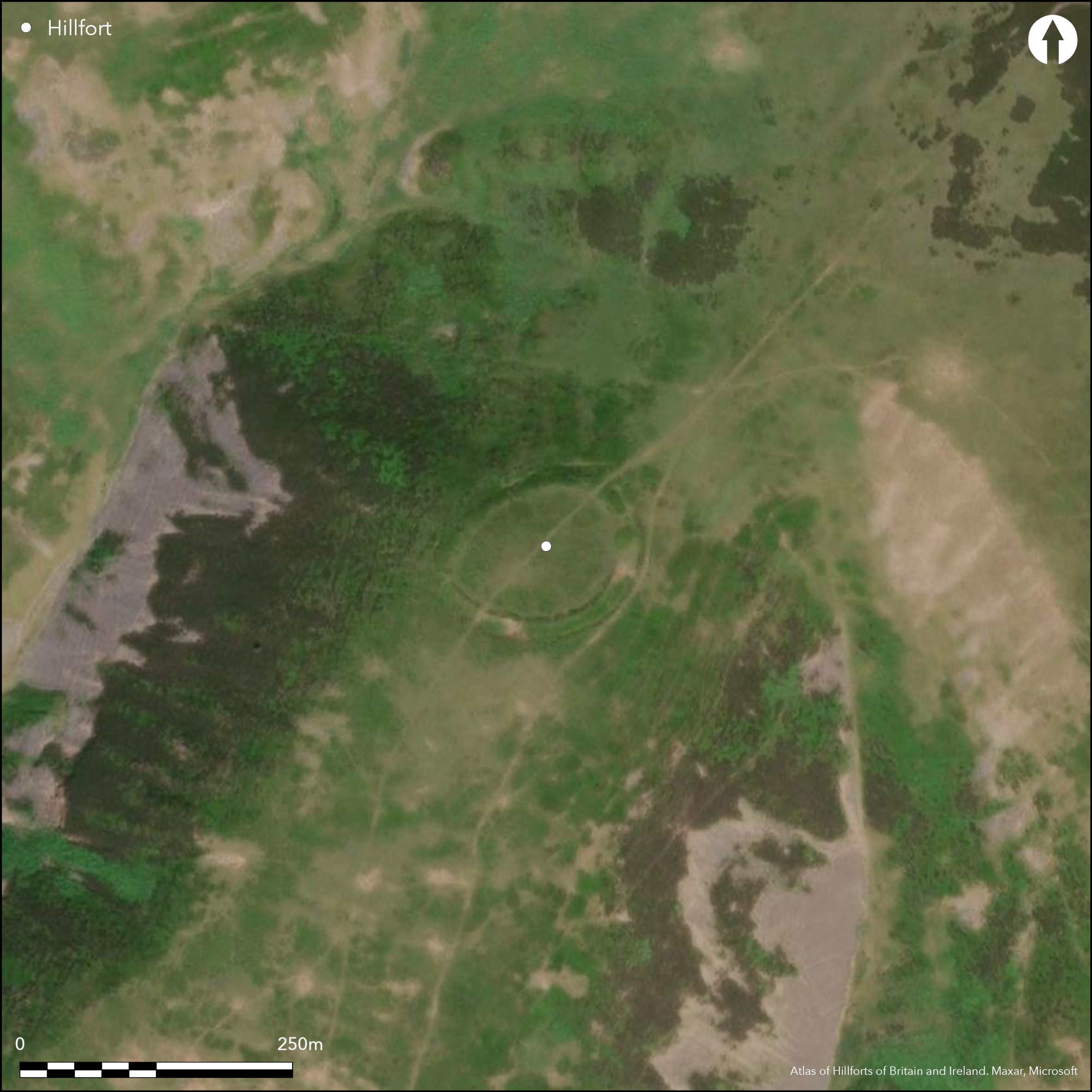
This fort is situated on the summit of Blackbrough Hill, which is itself the SW spur of the hill forming the summit at the S end of Craik Moor. The fort dominates a short steep slope rising out of the saddle on the NE, while elsewhere on the NW and SE the ground falls away sharply into Cribs Hope and Heather Hope respectively, and though the crest of the spur shelves more gently for some 200m to the SW, here again the slope plunges 180m down into the valley of the Heatherhope Burn. Oval on plan, the fort measures 85m from ENE to WSW by 65m transversely (0.43ha) within a single rampart with an external ditch, both presenting such a ragged appearance that in 1985 Roger Mercer suggested that the defences were unfinished. Be that as it may, these are amongst the most substantial fort defences to be found anywhere in the northern Cheviots, with a rampart 9m to 12m in thickness by between 0.9m and 1.5m in height internally and 4.5m externally, and a ditch up to 4.5m in breadth by 1.2m in depth. There are entrances on the NE and SW, the former opening onto the saddle and flanked by the rampart which turns out to either side of the gap to create a passage descending between the terminals of the diches, a feature more usually associated with entrances where inner an outer ramparts return and unite. In addition to the fort defences, there is also an oval palisaded enclosure lying at in the middle of the interior and measuring some 33m from NW to SE by 26m transversely. On its N side traces of a large timber round-house defined by a shallow groove are visible, while Mercer noted another smaller example apparently cut by the palisade trench on the S. This latter is one of a row of four he found, while elsewhere in the interior of the fort he noted a scatter of shallow and irregular scoops and platforms, one cut through the palisade trench. The only other features of note are a rough line of pits he noted outside the defences on the S, and a bank and ditch cut through the outer lip of the fort ditch on the ESE; descending a short distance down the slope, it blocks access round the SE side of the fort, but it is unclear whether this is merely a later boundary or a feature of the defences.
Citizen Science: ✗
Reliability of Data: Confirmed
Reliability of Interpretation: Confirmed
X: -256499 Y: 7450275 (EPSG: 3857)
Longitude: -2.3041725269506634 Latitude: 55.45294793679241 (EPSG:4326)
Country: Scotland
Current County or Unitary Authority: Scottish Borders
Historic County: Roxburghshire
Current Parish/Community/Council/Townland: Hownam
None
| Extant | ✓ |
| Cropmark | ✗ |
| Likely Destroyed | ✗ |
None
| Woodland | ✗ |
| Commercial Forestry Plantation | ✗ |
| Parkland | ✗ |
| Pasture (Grazing) | ✓ |
| Arable | ✗ |
| Scrub/Bracken | ✗ |
| Bare Outcrop | ✗ |
| Heather/Moorland | ✓ |
| Heath | ✗ |
| Built-up | ✗ |
| Coastal Grassland | ✗ |
| Other | ✗ |
None
| Contour Fort | ✓ |
| Partial Contour Fort | ✗ |
| Promontory Fort | ✗ |
| Hillslope Fort | ✗ |
| Level Terrain Fort | ✗ |
| Marsh Fort | ✗ |
| Multiple Enclosure Fort | ✗ |
| Hilltop | ✓ |
| Coastal Promontory | ✗ |
| Inland Promontory | ✗ |
| Valley Bottom | ✗ |
| Knoll/Hillock/Outcrop | ✗ |
| Ridge | ✗ |
| Cliff/Plateau-edge/Scarp | ✗ |
| Hillslope | ✗ |
| Lowland | ✗ |
| Spur | ✓ |
Dominant Topographic Feature: None
| North | ✗ |
| Northeast | ✗ |
| East | ✗ |
| Southeast | ✗ |
| South | ✗ |
| Southwest | ✗ |
| West | ✗ |
| Northwest | ✗ |
| Level | ✓ |
Altitude: 420.0m
N/A
In the absence of excavation, there are neither stratified artefacts nor radiocarbon dates to provide a chronology for the defences.
Reliability: D - None
| Pre 1200BC | ✗ |
| 1200BC - 800BC | ✗ |
| 800BC - 400BC | ✗ |
| 400BC - AD50 | ✗ |
| AD50 - AD400 | ✗ |
| AD400 - AD 800 | ✗ |
| Post AD800 | ✗ |
| Unknown | ✓ |
| Pre Hillfort: | None |
| Post Hillfort: | Possibly the palisaded enclosure is inserted into the interior. A minor bank and ditch also appear to cut the defences, tailing off after a short distance downslope |
Photographed from the air by Dennis Harding in 1982 and 1983, CUCAP in 1948, and by RCAHMS Aerial Survey Programme in 1977, 1993, 2000 and 2010
| 1st Identified Map Depiction (1859): | Annotated Fort on the 1st edition OS 25-inch map (Roxburgh 1863, sheet 22.16) |
| Other (1897): | Description by Francis Lynn (1898, 194-5) |
| Earthwork Survey (1938): | Plan of the earthwork (RCAHMS RXD 120/2) |
| Earthwork Survey (1949): | Palisade added to plan and description (RCAHMS 1956, 162, no.302, fig 188; RXD 120/1-2) |
| Other (1960): | visited by the OS |
| Other (1961): | Scheduled |
| Other (1976): | Visited by the OS |
| Earthwork Survey (1985): | Plan and description by Roger Mercer (RCAHMS DC15908, DC48748, DC48753; overall plan DC48811 & DP100546) |
| Other (1987): | Visited by the Hill-Fort Study Group |
Apart from a palisaded enclosure containing a timber round-house, there are traces of four other small round-houses defined by shallow grooves, one of which Mercer suggests dayes from before the palisade. He also suggests that there are at least seven platforms within the interior of the fort, though his plan shows eleven, and one of these is cut through the palisade trench.
None
| None | ✓ |
| Spring | ✗ |
| Stream | ✗ |
| Pool | ✗ |
| Flush | ✗ |
| Well | ✗ |
| Other | ✗ |
Ring-grooves
| No Known Features | ✗ |
| Round Stone Structures | ✗ |
| Rectangular Stone Structures | ✗ |
| Curvilinear Platforms | ✓ |
| Other Roundhouse Evidence | ✓ |
| Pits | ✗ |
| Quarry Hollows | ✗ |
| Other | ✗ |
None
| No Known Excavation | ✓ |
| Pits | ✗ |
| Postholes | ✗ |
| Roundhouses | ✗ |
| Rectangular Structures | ✗ |
| Roads/Tracks | ✗ |
| Quarry Hollows | ✗ |
| Other | ✗ |
| Nothing Found | ✗ |
None
| No Known Geophysics | ✓ |
| Pits | ✗ |
| Roundhouses | ✗ |
| Rectangular Structures | ✗ |
| Roads/Tracks | ✗ |
| Quarry Hollows | ✗ |
| Other | ✗ |
| Nothing Found | ✗ |
None
| No Known Finds | ✓ |
| Pottery | ✗ |
| Metal | ✗ |
| Metalworking | ✗ |
| Human Bones | ✗ |
| Animal Bones | ✗ |
| Lithics | ✗ |
| Environmental | ✗ |
| Other | ✗ |
Several of the ring-grooves can be made out
| APs Not Checked | ✗ |
| None | ✗ |
| Roundhouses | ✓ |
| Rectangular Structures | ✗ |
| Pits | ✗ |
| Postholes | ✗ |
| Roads/Tracks | ✗ |
| Other | ✗ |
See main summary
| 2: | None |
| 2: | None |
Guard Chambers: ✗
Chevaux de Frise: ✗
| 1. Passage-way/Corridor (North east): | Possibly part of an arrangement comparable to those where the ramparts return and unite around the terminals of the ditch, though little trace of a counterscarp bank |
| 1. Out-turned (North east): | Absence of clear evidence of a counterscarp bank has led to this being included as a possible out-turn |
| 3. Simple Gap (South west): | None |
A single rampart and ditch
| Area 1: | 0.43ha. |
| Area 2: | 0.8ha. |
| Total: | 0.8ha. |
Total Footprint Area: Noneha.
None
| ✓ | Mercer argues for a threefold sequence of occupation within the interior, though not in relation to the perimeter; evidence elsewhere that the process of occupation tends to destroy traces of earlier features, suggests that the palisaded enclosure may date from after the occupation of the fort, though if, as Mercer believes, the defences are unfinished, then this sequence may be reversed. |
| ✓ | None |
| NE Quadrant: | 1 |
| SE Quadrant: | 1 |
| SW Quadrant: | 1 |
| NW Quadrant: | 1 |
| Total: | 1 |
| Partial Univallate | ✗ |
| Univallate | ✓ |
| Partial Bivallate | ✗ |
| Bivallate | ✗ |
| Partial Multivallate | ✗ |
| Multivallate | ✗ |
| Unknown | ✗ |
| Partial Univallate | ✗ |
| Univallate | ✗ |
| Partial Bivallate | ✗ |
| Bivallate | ✗ |
| Partial Multivallate | ✗ |
| Multivallate | ✗ |
While Mercer suggests that the defences are unfinished, this explanation of irregularities in the profiles of both the rampart and ditch are not particularly convincing, and nor is the line of pits outside the defences on the S convincing as an unfinished line of defence.
| None | ✗ |
| Earthen Bank | ✓ |
| Stone Wall | ✗ |
| Rubble | ✗ |
| Wall-walk | ✗ |
| Evidence of Timber | ✗ |
| Vitrification | ✗ |
| Other Burning | ✗ |
| Palisade | ✓ |
| Counter Scarp Bank | ✗ |
| Berm | ✗ |
| Unfinished | ✓ |
| Other | ✗ |
None
| None | ✗ |
| Earthen Bank | ✗ |
| Stone Wall | ✗ |
| Murus Duplex | ✗ |
| Timber-framed | ✗ |
| Timber-laced | ✗ |
| Vitrification | ✗ |
| Other Burning | ✗ |
| Palisade | ✗ |
| Counter Scarp Bank | ✗ |
| Berm | ✗ |
| Unfinished | ✗ |
| No Known Excavation | ✓ |
| Other | ✗ |
| ✗ | None |
| ✓ | None |
Number of Ditches: 1
| ✗ | None |
Lynn, F (1898) 'The heads of Bowmont Water'. Hist Berwickshire Natur Club 16 (1896-8), 185-200
RCAHMS (1956) The Royal Commission on the Ancient and Historical Monuments of Scotland. An inventory of the ancient and historical monuments of Roxburghshire: with the fourteenth report of the Commission, 2v. HMSO: Edinburgh
Atlas of Hillforts:
Wikidata:
This work is licensed under CC BY-SA 4.0![]()
![]()
![]() and should be cited as:
and should be cited as:
Lock, Gary and Ralston, Ian. 2024. Atlas of Hillforts of Britain and Ireland. Available at: https://hillforts.arch.ox.ac.uk
Document Version 1.1