Satellite Imagery
Satellite Imagery
HER: Scottish Borders 59057 (None)
NMR: NT 81 NW 34 (59057)
SM: 1704
NGR: NT 8159 1679
X: 381590 Y: 616790 (OSGB36)
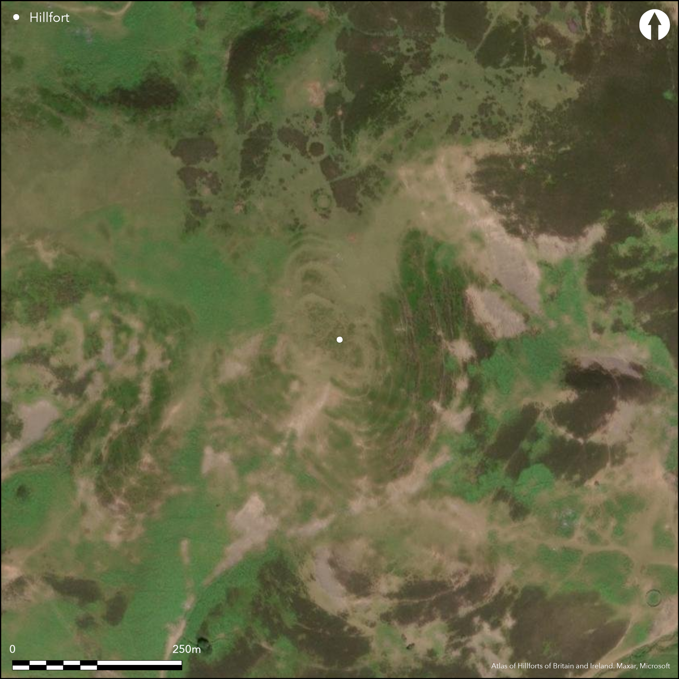
A spectacular fort occupies the summit of Sundhope Kipp, a spur which rises sharply southwards above a saddle linking it to the higher ground on the NE. Roughly oval on plan, the defences have been tailored to the topography, following the lip of the slope from which the ground falls away sharply some 150m into the valley on the E, S and W, and comprising at least two ramparts around the greater part of the circuit and a further two with external ditches and a counterscarp bank barring the easiest line of approach from the NNW. The inner two ramparts are reduced for the most part to scarps, the outer the faintest of features on the steep slope around the southern half, but on the NNE and NNW, where they follow the lip of the summit and a natural terrace stepping down the slope below, they form thick grass-grown banks, the inner turning outwards to either side of the entrance on the ENE as if originally uniting with the second rampart to either side of the passageway. On the N the second rampart is fronted by a ditch dug some way down the slope below, immediately beyond which the third and fourth ramparts form concentric arcs with external ditches descending into the saddle on this side. In all the belt of defences is 50m deep on this side, though this includes a space up to 20m broad between the innermost and second ramaprt. At the ENE entrance, the track approaches from the N below the outer ramparts, exposing the visitor's right side, but at a second break on the NW, if original, it is the left side that is exposed; in 1985 Roger Mercer suggested there was possibly also a third entrance at the S tip of the fort. The interior of the fort, which measures about 82m from NNW to SSE by 50m transversely (0.3ha), is packed with traces of at least twenty-four inter-cutting timber round-houses, representing several periods of occupation and mainly comprising low tumps encircled by shallow grooves and ditches with low external banks; in six cases there is no more than a shallow groove to define the stance and Mercer's survey of 1985 suggested that these were earlier than those with broader ring-ditches. The projected circuits of two grooves on the W are truncated by the reduction of the rampart to its present eroded line, though whether they are earlier or later cannot be determined without excavation, but several of the ring-ditch houses elsewhere appear to impinge on the inner rampart and are likely to post-date its dereliction. Whether this indicates that some of the outer defences represent a free-standing fortification constructed after innermost rampart had been abandoned, as suggested by Mercer, cannot be demonstrated. A rectangular building lying immediately to the rear of the second rampart on the N, however, and another two in the ditch at the rear of the third rampart are presumably later shielings.
Citizen Science: ✗
Reliability of Data: Confirmed
Reliability of Interpretation: Confirmed
X: -255208 Y: 7448649 (EPSG: 3857)
Longitude: -2.292569024358316 Latitude: 55.44466443413902 (EPSG:4326)
Country: Scotland
Current County or Unitary Authority: Scottish Borders
Historic County: Roxburghshire
Current Parish/Community/Council/Townland: Hownam
None
| Extant | ✓ |
| Cropmark | ✗ |
| Likely Destroyed | ✗ |
None
| Woodland | ✗ |
| Commercial Forestry Plantation | ✗ |
| Parkland | ✗ |
| Pasture (Grazing) | ✓ |
| Arable | ✗ |
| Scrub/Bracken | ✗ |
| Bare Outcrop | ✗ |
| Heather/Moorland | ✓ |
| Heath | ✗ |
| Built-up | ✗ |
| Coastal Grassland | ✗ |
| Other | ✗ |
None
| Contour Fort | ✓ |
| Partial Contour Fort | ✗ |
| Promontory Fort | ✗ |
| Hillslope Fort | ✗ |
| Level Terrain Fort | ✗ |
| Marsh Fort | ✗ |
| Multiple Enclosure Fort | ✗ |
| Hilltop | ✓ |
| Coastal Promontory | ✗ |
| Inland Promontory | ✗ |
| Valley Bottom | ✗ |
| Knoll/Hillock/Outcrop | ✗ |
| Ridge | ✗ |
| Cliff/Plateau-edge/Scarp | ✗ |
| Hillslope | ✗ |
| Lowland | ✗ |
| Spur | ✓ |
Dominant Topographic Feature: None
| North | ✗ |
| Northeast | ✗ |
| East | ✗ |
| Southeast | ✗ |
| South | ✗ |
| Southwest | ✗ |
| West | ✗ |
| Northwest | ✗ |
| Level | ✓ |
Altitude: 419.0m
N/A
In the absence of excavation, there are neither stratified artefacts nor radiocarbon dates to provide a chronology for the defences.
Reliability: D - None
| Pre 1200BC | ✗ |
| 1200BC - 800BC | ✗ |
| 800BC - 400BC | ✗ |
| 400BC - AD50 | ✗ |
| AD50 - AD400 | ✗ |
| AD400 - AD 800 | ✗ |
| Post AD800 | ✗ |
| Unknown | ✓ |
| Pre Hillfort: | None |
| Post Hillfort: | Some of the timber round-houses, themselves in inter-cutting sequences, probably post-date the defences |
Photographed from the air by Dennis Harding in 1982 and 1983, and by RCAHMS Aerial Survey Programme in 1994, 2000 and 2010.
| Earthwork Survey (1938): | Plan and description (RCAHMS 1956, 162-3, no.303, fig 189; RCAHMS RXD 122/1-2) |
| Other (1958): | Scheduled |
| 1st Identified Map Depiction (1960): | Visited by the OS |
| Other (1976): | Visited by the OS |
| Earthwork Survey (1985): | Plan and description by Roger Mercer (RCAHMS DC15910-11, DC15923, DC15932-35, DC15950-1, DC16089-90, DC48744, DC48786-7; overall plan DC48829 & DP100564) |
| Other (1987): | Visited by the Hill-Fort Study Group |
| Other (1993): | Re-Scheduled |
The interior of the fort is packed with traces of at least twenty-four intercutting timber round-houses, representing several periods of occupation. Eighteen comprise low tumps encircled by shallow grooves and ditches with low external banks; six are no more than shallow grooves and Mercer believed that these were earlier than those with broader ring-ditches. The circuits of two grooves on the W are truncated by the reduction of the rampart to its present eroded line, though whether they are earlier or later cannot be determined without excavation, but elsewhere several of the ring-ditch houses appear to cut the inner rampart and are likely to post-date its dereliction. While Mercer employs the term 'street' to describe two of the groups of round-houses he observes within the interior, the evidence for such an organisation of the interior is difficult to sustain in the complex sequences represented by the visible remains.
None
| None | ✓ |
| Spring | ✗ |
| Stream | ✗ |
| Pool | ✗ |
| Flush | ✗ |
| Well | ✗ |
| Other | ✗ |
Traces of up to twenty-four timber round-houses defined by ring-ditches and ring-grooves. In addition one rectangular building lies in the rear of the second rampart on the N and another two behind the third, though these probably relate to the use of the spur as a shieling. Ring-ditch houses
| No Known Features | ✗ |
| Round Stone Structures | ✗ |
| Rectangular Stone Structures | ✓ |
| Curvilinear Platforms | ✗ |
| Other Roundhouse Evidence | ✓ |
| Pits | ✗ |
| Quarry Hollows | ✗ |
| Other | ✗ |
None
| No Known Excavation | ✓ |
| Pits | ✗ |
| Postholes | ✗ |
| Roundhouses | ✗ |
| Rectangular Structures | ✗ |
| Roads/Tracks | ✗ |
| Quarry Hollows | ✗ |
| Other | ✗ |
| Nothing Found | ✗ |
None
| No Known Geophysics | ✓ |
| Pits | ✗ |
| Roundhouses | ✗ |
| Rectangular Structures | ✗ |
| Roads/Tracks | ✗ |
| Quarry Hollows | ✗ |
| Other | ✗ |
| Nothing Found | ✗ |
None
| No Known Finds | ✓ |
| Pottery | ✗ |
| Metal | ✗ |
| Metalworking | ✗ |
| Human Bones | ✗ |
| Animal Bones | ✗ |
| Lithics | ✗ |
| Environmental | ✗ |
| Other | ✗ |
Spectacularly revealed by oblique aerial photographs
| APs Not Checked | ✗ |
| None | ✗ |
| Roundhouses | ✓ |
| Rectangular Structures | ✗ |
| Pits | ✗ |
| Postholes | ✗ |
| Roads/Tracks | ✗ |
| Other | ✗ |
See main summary
| 3: | None |
| 2: | None |
Guard Chambers: ✗
Chevaux de Frise: ✗
| 1. Passage-way/Corridor (East): | With a trackway that turns northwards below the inner and second rampart below the outer ramparts. Oblique approach exposing right side |
| 1. Oblique (East): | With a trackway that turns northwards below the inner and second rampart below the outer ramparts. Oblique approach exposing right side |
| 2. Simple Gap (South east): | Gap in the inner rampart |
| 3. Oblique (North west): | Along the lip of the slope. Oblique approach exposing left side below the second and outer ramparts |
| 3. Simple Gap (North west): | None |
Inner rampart with a second rampart around most of the circuit, with an external ditch on the N and NNW, and third and fourth ramparts with external ditches on the NNW
| Area 1: | 0.3ha. |
| Total: | 0.3ha. |
Total Footprint Area: 0.82ha.
None
| ✗ | None |
| ✓ | None |
| NE Quadrant: | 2 |
| SE Quadrant: | 2 |
| SW Quadrant: | 2 |
| NW Quadrant: | 4 |
| Total: | 4 |
| Partial Univallate | ✗ |
| Univallate | ✗ |
| Partial Bivallate | ✓ |
| Bivallate | ✗ |
| Partial Multivallate | ✓ |
| Multivallate | ✗ |
| Unknown | ✗ |
| Partial Univallate | ✗ |
| Univallate | ✗ |
| Partial Bivallate | ✗ |
| Bivallate | ✗ |
| Partial Multivallate | ✗ |
| Multivallate | ✗ |
None
| None | ✗ |
| Earthen Bank | ✓ |
| Stone Wall | ✗ |
| Rubble | ✗ |
| Wall-walk | ✗ |
| Evidence of Timber | ✗ |
| Vitrification | ✗ |
| Other Burning | ✗ |
| Palisade | ✗ |
| Counter Scarp Bank | ✗ |
| Berm | ✗ |
| Unfinished | ✗ |
| Other | ✗ |
None
| None | ✗ |
| Earthen Bank | ✗ |
| Stone Wall | ✗ |
| Murus Duplex | ✗ |
| Timber-framed | ✗ |
| Timber-laced | ✗ |
| Vitrification | ✗ |
| Other Burning | ✗ |
| Palisade | ✗ |
| Counter Scarp Bank | ✗ |
| Berm | ✗ |
| Unfinished | ✗ |
| No Known Excavation | ✓ |
| Other | ✗ |
| ✓ | None |
| ✓ | principally across the NNW approach, but possibly with a single ditch between the ramparts on the S and SE |
Number of Ditches: 3
| ✗ | None |
RCAHMS (1956) The Royal Commission on the Ancient and Historical Monuments of Scotland. An inventory of the ancient and historical monuments of Roxburghshire: with the fourteenth report of the Commission, 2v. HMSO: Edinburgh
Atlas of Hillforts:
Wikidata:
This work is licensed under CC BY-SA 4.0![]()
![]()
![]() and should be cited as:
and should be cited as:
Lock, Gary and Ralston, Ian. 2024. Atlas of Hillforts of Britain and Ireland. Available at: https://hillforts.arch.ox.ac.uk
Document Version 1.1