LiDAR 1m DTM Hillshade
Satellite Imagery
LiDAR 1m DTM Hillshade
Satellite Imagery
Scroll left/right to view further images.
HER: Scottish Borders 55715 (None)
NMR: NT 53 SW 1 (55715)
SM: 1725
NGR: NT 5155 3165
X: 351550 Y: 631650 (OSGB36)
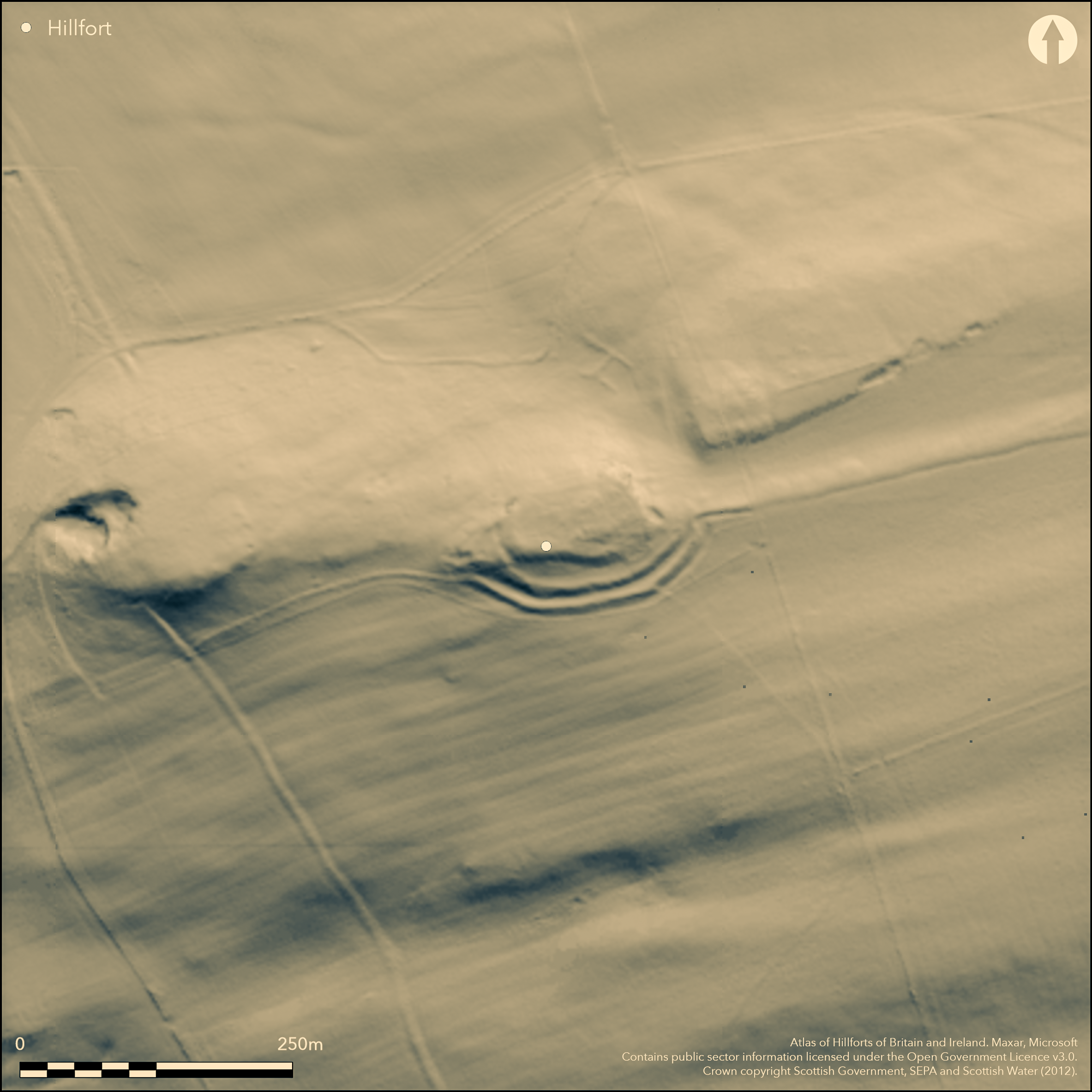
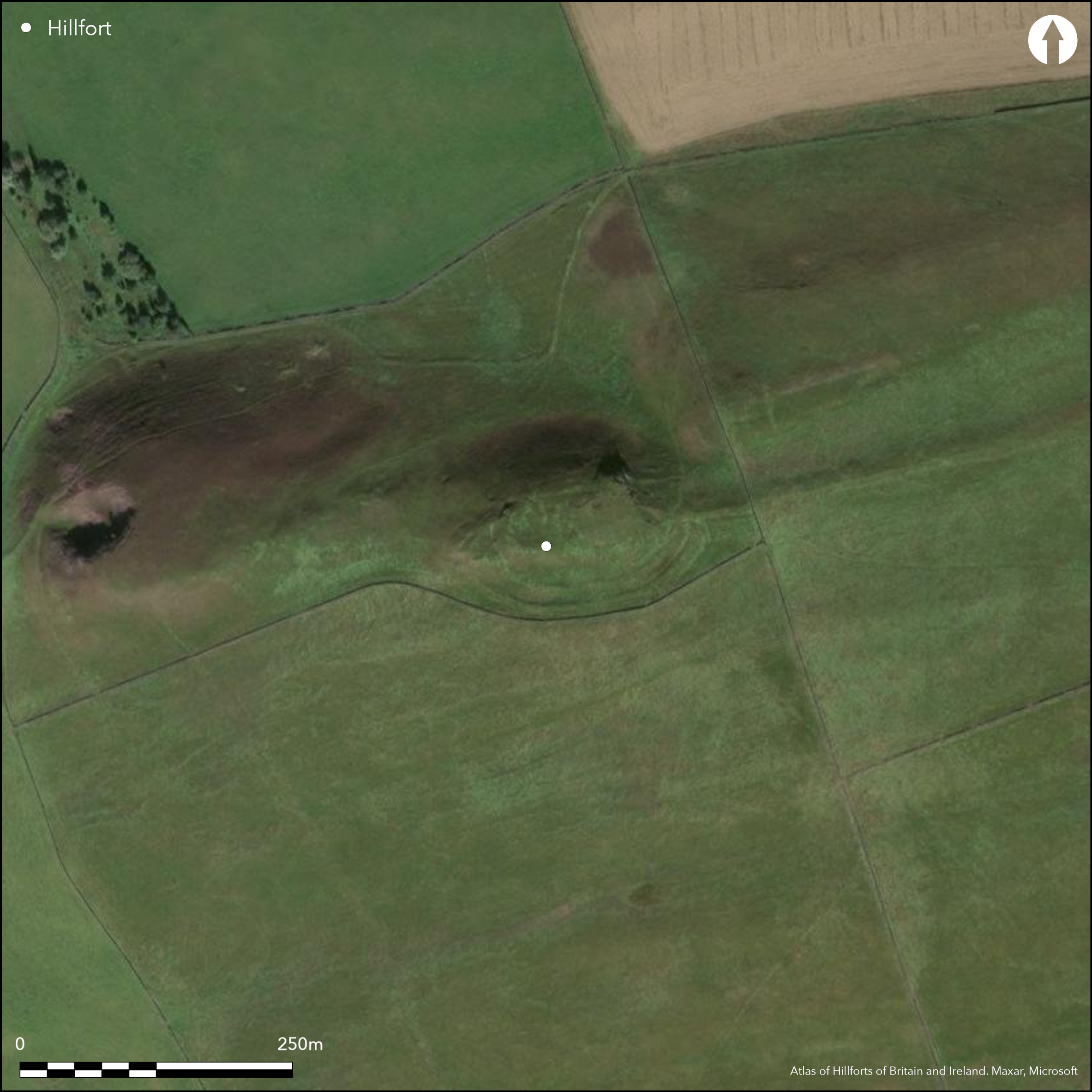
This fort occupies the summit knoll of Cauldshiels Hill, from which the ground shelves gently to the SE and E, but drops away dramatically to Cauldshiels Loch along the N flank. Roughly oval on plan, the interior measures about 65m from E to W by 35m transversely. The inner rampart has been carried round the whole summit, but the main belt of outer defences, which comprises two ramparts with external ditches, extends only round the SE and SW flanks, their courses splaying westwards before they peter out on the W flank of the knoll, where two other scarps may represent further lines of defence between them. The entrance is on the E, but is blocked by a later linear earthwork which approaches from the E and adopts the outer rampart into its line; the date and purpose of the linear earthwork, one of a number on Bowden Moor, are unknown. The interior of the fort is apparently featureless, but excavation in 1991, conducted as part of research into Newstead, uncovered evidence of at least one circular timber building (Jones 1991). The excavation also revealed a complex sequence of gateway structures in the entrance on the E.
Citizen Science: ✗
Reliability of Data: Confirmed
Reliability of Interpretation: Confirmed
X: -308356 Y: 7474492 (EPSG: 3857)
Longitude: -2.7700063403329356 Latitude: 55.57612190183699 (EPSG:4326)
Country: Scotland
Current County or Unitary Authority: Scottish Borders
Historic County: Selkirkshire
Current Parish/Community/Council/Townland: Galashiels
None
Condition:| Extant | ✓ |
| Cropmark | ✗ |
| Likely Destroyed | ✗ |
None
Current Use:| Woodland | ✗ |
| Commercial Forestry Plantation | ✗ |
| Parkland | ✗ |
| Pasture (Grazing) | ✓ |
| Arable | ✗ |
| Scrub/Bracken | ✗ |
| Bare Outcrop | ✗ |
| Heather/Moorland | ✓ |
| Heath | ✗ |
| Built-up | ✗ |
| Coastal Grassland | ✗ |
| Other | ✗ |
None
Type:| Contour Fort | ✓ |
| Partial Contour Fort | ✗ |
| Promontory Fort | ✗ |
| Hillslope Fort | ✗ |
| Level Terrain Fort | ✗ |
| Marsh Fort | ✗ |
| Multiple Enclosure Fort | ✗ |
| Hilltop | ✓ |
| Coastal Promontory | ✗ |
| Inland Promontory | ✗ |
| Valley Bottom | ✗ |
| Knoll/Hillock/Outcrop | ✗ |
| Ridge | ✗ |
| Cliff/Plateau-edge/Scarp | ✗ |
| Hillslope | ✗ |
| Lowland | ✗ |
| Spur | ✗ |
Dominant Topographic Feature: None
| North | ✗ |
| Northeast | ✗ |
| East | ✗ |
| Southeast | ✗ |
| South | ✗ |
| Southwest | ✗ |
| West | ✗ |
| Northwest | ✗ |
| Level | ✓ |
Altitude: 329.0m
N/A
Excavation recovered a limited range of artefacts, namely whetstones and fragments of saddle quern. The defences are undated.
Reliability: D - None
Principal Activity:| Pre 1200BC | ✗ |
| 1200BC - 800BC | ✗ |
| 800BC - 400BC | ✗ |
| 400BC - AD50 | ✗ |
| AD50 - AD400 | ✗ |
| AD400 - AD 800 | ✗ |
| Post AD800 | ✗ |
| Unknown | ✓ |
| Pre Hillfort: | None |
| Post Hillfort: | Outer rampart is incorporated into the line of a later linear earthwork |
Photographed by RCAHMS Aerial Survey Programme in 1982, and by John Dent in 1991 and 1993. Date of 1934 attributed to RCAHMS plan (SED 13/1) should be checked to source.
| Other (1859): | Annotated Camp on the 1st edition OS 25-inch map (Roxburgh 1863, sheet 7.12) |
| Earthwork Survey (1894): | Sketch-plan and description by David Christison (1895, 125-6, fig 7) |
| Earthwork Survey (1934): | Date of survey attributed to plan for the county inventory (RCAHMS SED 13/2) |
| Earthwork Survey (1950): | Plan and description (RCAHMS 1957, 93-4, no.123, fig 115; SED 13/2) |
| Other (1961): | Surveyed at 1:2500 by the OS |
| Other (1961): | Scheduled |
| Geophysical Survey (1991): | (Jones et al 1991) |
| Excavation (1991): | (Jones et al 1991) |
Featureless on the surface but excavation revealed the stance of a timber round-house
None
Source:| None | ✓ |
| Spring | ✗ |
| Stream | ✗ |
| Pool | ✗ |
| Flush | ✗ |
| Well | ✗ |
| Other | ✗ |
None
Interior Features (Surface):| No Known Features | ✓ |
| Round Stone Structures | ✗ |
| Rectangular Stone Structures | ✗ |
| Curvilinear Platforms | ✗ |
| Other Roundhouse Evidence | ✗ |
| Pits | ✗ |
| Quarry Hollows | ✗ |
| Other | ✗ |
None
Interior Features (Excavation):| No Known Excavation | ✗ |
| Pits | ✓ |
| Postholes | ✓ |
| Roundhouses | ✓ |
| Rectangular Structures | ✗ |
| Roads/Tracks | ✗ |
| Quarry Hollows | ✗ |
| Other | ✗ |
| Nothing Found | ✗ |
None
Interior Features (Geophysics):| No Known Geophysics | ✓ |
| Pits | ✗ |
| Roundhouses | ✗ |
| Rectangular Structures | ✗ |
| Roads/Tracks | ✗ |
| Quarry Hollows | ✗ |
| Other | ✗ |
| Nothing Found | ✗ |
Whetstones and fragments of saddle quern (Jones et al 1991)
Interior (Finds):| No Known Finds | ✗ |
| Pottery | ✗ |
| Metal | ✗ |
| Metalworking | ✗ |
| Human Bones | ✗ |
| Animal Bones | ✗ |
| Lithics | ✗ |
| Environmental | ✗ |
| Other | ✓ |
NO APPARENT FEATURES
Interior Features (Aerial):| APs Not Checked | ✗ |
| None | ✓ |
| Roundhouses | ✗ |
| Rectangular Structures | ✗ |
| Pits | ✗ |
| Postholes | ✗ |
| Roads/Tracks | ✗ |
| Other | ✗ |
See main summary
Total Number of Breaks Through Ramparts:| 1: | None |
| 2: | None |
Guard Chambers: ✗
Chevaux de Frise: ✗
| 1. Simple Gap (East): | Blocked when the fort was incorporated into a linear earthwork. Excavation revealed a complex sequence of gateway structures. |
At least three ramparts everywhere except the N where there are traces of only the inner
Enclosed Area:| Area 1: | 0.21ha. |
| Total: | 0.21ha. |
Total Footprint Area: 0.74ha.
None
Multi-period Enclosure System:| ✓ | None |
| ✓ | None |
| NE Quadrant: | 1 |
| SE Quadrant: | 3 |
| SW Quadrant: | 3 |
| NW Quadrant: | 3 |
| Total: | 3 |
| Partial Univallate | ✓ |
| Univallate | ✗ |
| Partial Bivallate | ✗ |
| Bivallate | ✗ |
| Partial Multivallate | ✓ |
| Multivallate | ✗ |
| Unknown | ✗ |
| Partial Univallate | ✗ |
| Univallate | ✗ |
| Partial Bivallate | ✗ |
| Bivallate | ✗ |
| Partial Multivallate | ✗ |
| Multivallate | ✗ |
None
Enclosing Works (Surface):| None | ✗ |
| Earthen Bank | ✓ |
| Stone Wall | ✗ |
| Rubble | ✗ |
| Wall-walk | ✗ |
| Evidence of Timber | ✗ |
| Vitrification | ✗ |
| Other Burning | ✗ |
| Palisade | ✗ |
| Counter Scarp Bank | ✗ |
| Berm | ✗ |
| Unfinished | ✗ |
| Other | ✗ |
None
Enclosing Works (Excavation):| None | ✗ |
| Earthen Bank | ✓ |
| Stone Wall | ✓ |
| Murus Duplex | ✗ |
| Timber-framed | ✗ |
| Timber-laced | ✗ |
| Vitrification | ✗ |
| Other Burning | ✗ |
| Palisade | ✗ |
| Counter Scarp Bank | ✗ |
| Berm | ✗ |
| Unfinished | ✗ |
| No Known Excavation | ✗ |
| Other | ✗ |
| ✗ | None |
| ✓ | Around the S flank |
Number of Ditches: 2
Annex:| ✗ | None |
Christison, D (1895) 'The forts of Selkirk, the Gala Water, the Southern slopes of the Lammermoors, and the north of Roxburgh'. Proc Soc Antiq Scot 29 (1894-50), 108-79
Jones, R F J (1991) 'The Newstead project'. Univ Bradford Archaeol Sci Annu Rep, 1990-1, 5th annual report, p 15
RCAHMS (1957) The Royal Commission on the Ancient and Historical Monuments of Scotland. An inventory of the ancient and historical monuments of Selkirkshire with the fifteenth report of the Commission. HMSO: Edinburgh
This work is licensed under CC BY-SA 4.0![]()
![]()
![]() and should be cited as:
and should be cited as:
Lock, Gary and Ralston, Ian. 2024. Atlas of Hillforts of Britain and Ireland. Available at: https://hillforts.arch.ox.ac.uk
Document Version 1.1