
LiDAR 1m DTM Hillshade
Satellite Imagery
LiDAR 1m DTM Hillshade
Satellite Imagery
Scroll left/right to view further images.
HER: Scottish Borders 48511 (None)
NMR: NT 02 NE 2 (48511)
SM: 3084
NGR: NT 0918 2742
X: 309180 Y: 627420 (OSGB36)
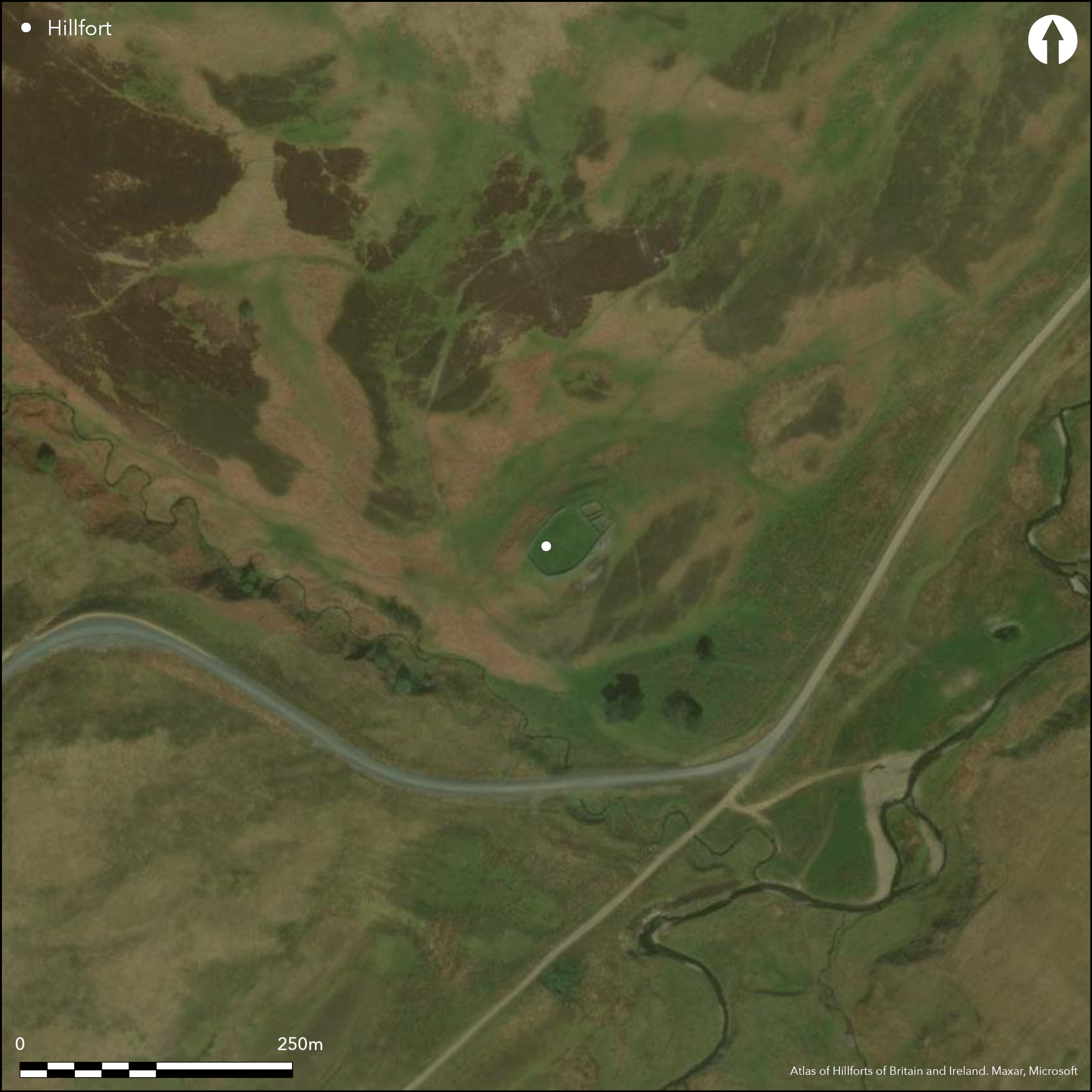
This small fortification occupies a low hillock rising out of the foot of the slope on the S flank of Glenkerie Rig. Oval on plan, its interior measures about 45m from NE to SW by 25m transversely (0.9ha), roughly approximating to the extent of a large walled sheepfold that overlies the fort. The defences comprise up to three ramparts, the inner of which has probably been a substantial wall though for much of its circuit it is reduced to a stony scarp with occasional outer facing; the outer ramparts, which are also reduced to scarps, are most clearly visible at the NE end, and as a result of cultivation neither now forms a complete circuit. The entrance is on the NE and while the SE side of the interior is slightly sunken no clear house-plaforms are visible.
Citizen Science: ✗
Reliability of Data: Confirmed
Reliability of Interpretation: Confirmed
X: -382990 Y: 7465821 (EPSG: 3857)
Longitude: -3.4404543667131136 Latitude: 55.53206399609478 (EPSG:4326)
Country: Scotland
Current County or Unitary Authority: Scottish Borders
Historic County: Peeblesshire
Current Parish/Community/Council/Townland: Drumelzier
None
| Extant | ✓ |
| Cropmark | ✗ |
| Likely Destroyed | ✗ |
None
| Woodland | ✗ |
| Commercial Forestry Plantation | ✗ |
| Parkland | ✗ |
| Pasture (Grazing) | ✓ |
| Arable | ✗ |
| Scrub/Bracken | ✗ |
| Bare Outcrop | ✗ |
| Heather/Moorland | ✓ |
| Heath | ✗ |
| Built-up | ✗ |
| Coastal Grassland | ✗ |
| Other | ✗ |
None
| Contour Fort | ✓ |
| Partial Contour Fort | ✗ |
| Promontory Fort | ✗ |
| Hillslope Fort | ✗ |
| Level Terrain Fort | ✗ |
| Marsh Fort | ✗ |
| Multiple Enclosure Fort | ✗ |
| Hilltop | ✗ |
| Coastal Promontory | ✗ |
| Inland Promontory | ✗ |
| Valley Bottom | ✗ |
| Knoll/Hillock/Outcrop | ✓ |
| Ridge | ✗ |
| Cliff/Plateau-edge/Scarp | ✗ |
| Hillslope | ✗ |
| Lowland | ✗ |
| Spur | ✗ |
Dominant Topographic Feature: None
| North | ✗ |
| Northeast | ✗ |
| East | ✗ |
| Southeast | ✗ |
| South | ✗ |
| Southwest | ✗ |
| West | ✗ |
| Northwest | ✗ |
| Level | ✓ |
Altitude: 298.0m
N/A
In the absence of excavation, there are neither stratified artefacts nor radiocarbon dates to provide a chronology for the defences.
Reliability: D - None
| Pre 1200BC | ✗ |
| 1200BC - 800BC | ✗ |
| 800BC - 400BC | ✗ |
| 400BC - AD50 | ✗ |
| AD50 - AD400 | ✗ |
| AD400 - AD 800 | ✗ |
| Post AD800 | ✗ |
| Unknown | ✓ |
| Pre Hillfort: | None |
| Post Hillfort: | Occupied by a stone-walled sheepfold and the outer ramparts reduced by post-medieval ploughing |
Photographed by RCAHMS Aerial Survey Programme in 1981 and 2010
| 1st Identified Map Depiction (1775): | Concentric ring symbol on Mostyn Armstrong's map of The County of Peebles or Tweedale (1775) |
| Earthwork Survey (1956): | Plan and description (RCAHMS 1967, 126, no.295, fig 111; RCAHMS PBD 119/1-2) |
| Other (1971): | Scheduled |
| Other (1974): | Revised at 1:10,560 by the OS |
Area along the SE side of the interior is scooped into the slope but there are no clear house-platforms
None
| None | ✓ |
| Spring | ✗ |
| Stream | ✗ |
| Pool | ✗ |
| Flush | ✗ |
| Well | ✗ |
| Other | ✗ |
Area of scooping along the SE side of the inteiror
| No Known Features | ✗ |
| Round Stone Structures | ✗ |
| Rectangular Stone Structures | ✗ |
| Curvilinear Platforms | ✗ |
| Other Roundhouse Evidence | ✗ |
| Pits | ✗ |
| Quarry Hollows | ✗ |
| Other | ✓ |
None
| No Known Excavation | ✓ |
| Pits | ✗ |
| Postholes | ✗ |
| Roundhouses | ✗ |
| Rectangular Structures | ✗ |
| Roads/Tracks | ✗ |
| Quarry Hollows | ✗ |
| Other | ✗ |
| Nothing Found | ✗ |
None
| No Known Geophysics | ✓ |
| Pits | ✗ |
| Roundhouses | ✗ |
| Rectangular Structures | ✗ |
| Roads/Tracks | ✗ |
| Quarry Hollows | ✗ |
| Other | ✗ |
| Nothing Found | ✗ |
None
| No Known Finds | ✓ |
| Pottery | ✗ |
| Metal | ✗ |
| Metalworking | ✗ |
| Human Bones | ✗ |
| Animal Bones | ✗ |
| Lithics | ✗ |
| Environmental | ✗ |
| Other | ✗ |
NO APPARENT FEATURES
| APs Not Checked | ✓ |
| None | ✗ |
| Roundhouses | ✗ |
| Rectangular Structures | ✗ |
| Pits | ✗ |
| Postholes | ✗ |
| Roads/Tracks | ✗ |
| Other | ✗ |
See main summary
| 1: | None |
| 2: | None |
Guard Chambers: ✗
Chevaux de Frise: ✗
| 1. Simple Gap (North east): | None |
Three ramparts
| Area 1: | 0.9ha. |
| Total: | 0.9ha. |
Total Footprint Area: 0.31ha.
None
| ✗ | None |
| ✓ | None |
| NE Quadrant: | 3 |
| SE Quadrant: | 2 |
| SW Quadrant: | 2 |
| NW Quadrant: | 2 |
| Total: | 3 |
| Partial Univallate | ✗ |
| Univallate | ✗ |
| Partial Bivallate | ✓ |
| Bivallate | ✗ |
| Partial Multivallate | ✓ |
| Multivallate | ✗ |
| Unknown | ✗ |
| Partial Univallate | ✗ |
| Univallate | ✗ |
| Partial Bivallate | ✗ |
| Bivallate | ✗ |
| Partial Multivallate | ✗ |
| Multivallate | ✗ |
None
| None | ✗ |
| Earthen Bank | ✓ |
| Stone Wall | ✓ |
| Rubble | ✗ |
| Wall-walk | ✗ |
| Evidence of Timber | ✗ |
| Vitrification | ✗ |
| Other Burning | ✗ |
| Palisade | ✗ |
| Counter Scarp Bank | ✗ |
| Berm | ✗ |
| Unfinished | ✗ |
| Other | ✗ |
None
| None | ✗ |
| Earthen Bank | ✗ |
| Stone Wall | ✗ |
| Murus Duplex | ✗ |
| Timber-framed | ✗ |
| Timber-laced | ✗ |
| Vitrification | ✗ |
| Other Burning | ✗ |
| Palisade | ✗ |
| Counter Scarp Bank | ✗ |
| Berm | ✗ |
| Unfinished | ✗ |
| No Known Excavation | ✓ |
| Other | ✗ |
| ✗ | None |
| ✗ | None |
Number of Ditches: None
| ✗ | None |
RCAHMS (1967) The Royal Commission on the Ancient and Historical Monuments of Scotland. Peeblesshire: an inventory of the ancient monuments, 2v. HMSO: Edinburgh
Atlas of Hillforts:
Wikidata:
This work is licensed under CC BY-SA 4.0![]()
![]()
![]() and should be cited as:
and should be cited as:
Lock, Gary and Ralston, Ian. 2024. Atlas of Hillforts of Britain and Ireland. Available at: https://hillforts.arch.ox.ac.uk
Document Version 1.1