Satellite Imagery
Satellite Imagery
HER: Scottish Borders 49788 (None)
NMR: NT 12 NW 5 (49788)
SM: 2675
NGR: NT 1200 2950
X: 312005 Y: 629505 (OSGB36)
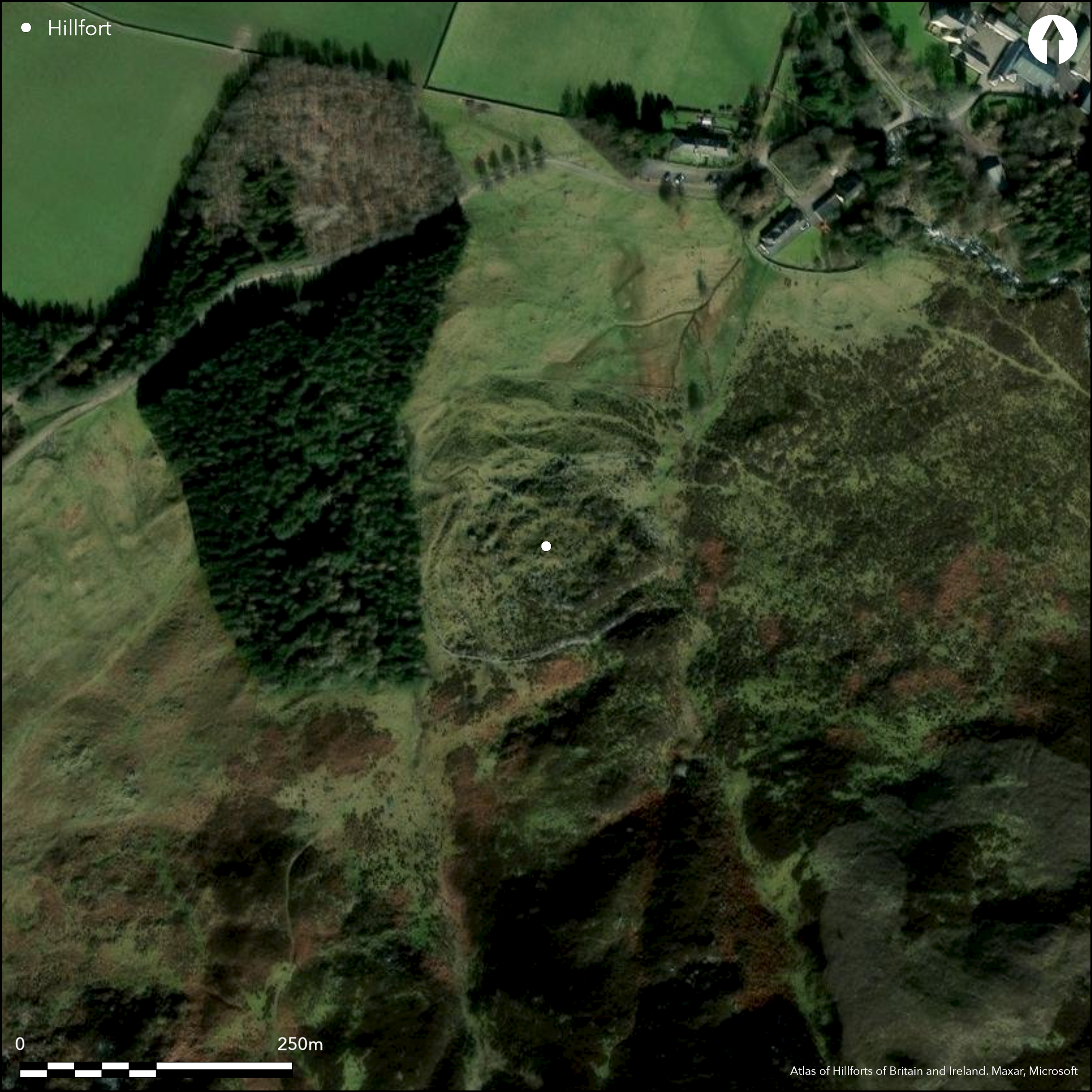
This is one of the more extraordinary forts in Peeblesshire, occupying a rocky rib between two shallow gullies on the steep,boulder-strewn slope forming the N flank of Laigh Hill opposite Stanhope farmhouse. Nevertheless, two walls pursue irregular circuits through the the outcrops, each reduced to a band of rubble with numerous outer facing-stones and a few inner facing stones visible around the upper, S side, and while the inner is some 3.5m thick, the outer is 3m thick. The area they enclose is roughly oval, measuring 52m from E to W by 46m transversely (0.18ha), contains nine circular house-platforms, most of which are encircled by thin rickles of stones. In addition to the inner defences, an outer wall some 2.4m in thickness, accompanied around the uphill side by an external ditch, encloses an additional 0.7ha around the fort, forming an irregular enclosure taking in the gullies to either side and the steep slopes above an below. Within this area a single house platform can be seen on the W, above the entrance. The latter passes through a gap in the outermost wall on the WNW, which is lined with slabs set on edge, and is flanked on the N by a row of boulders as it approaches the gap formed in the medial wall by two massive natural boulders, the larger up to 2.7m high; the oblique axis of the entrance exposes the visitor's right side at the innermost wall.
Citizen Science: ✗
Reliability of Data: Confirmed
Reliability of Interpretation: Confirmed
X: -378083 Y: 7469608 (EPSG: 3857)
Longitude: -3.3963753876859006 Latitude: 55.55131119515359 (EPSG:4326)
Country: Scotland
Current County or Unitary Authority: Scottish Borders
Historic County: Peeblesshire
Current Parish/Community/Council/Townland: Drumelzier
None
| Extant | ✓ |
| Cropmark | ✗ |
| Likely Destroyed | ✗ |
None
| Woodland | ✗ |
| Commercial Forestry Plantation | ✗ |
| Parkland | ✗ |
| Pasture (Grazing) | ✓ |
| Arable | ✗ |
| Scrub/Bracken | ✗ |
| Bare Outcrop | ✗ |
| Heather/Moorland | ✓ |
| Heath | ✗ |
| Built-up | ✗ |
| Coastal Grassland | ✗ |
| Other | ✗ |
None
| Contour Fort | ✗ |
| Partial Contour Fort | ✗ |
| Promontory Fort | ✗ |
| Hillslope Fort | ✓ |
| Level Terrain Fort | ✗ |
| Marsh Fort | ✗ |
| Multiple Enclosure Fort | ✓ |
| Hilltop | ✗ |
| Coastal Promontory | ✗ |
| Inland Promontory | ✗ |
| Valley Bottom | ✗ |
| Knoll/Hillock/Outcrop | ✗ |
| Ridge | ✗ |
| Cliff/Plateau-edge/Scarp | ✗ |
| Hillslope | ✓ |
| Lowland | ✗ |
| Spur | ✗ |
Dominant Topographic Feature: None
| North | ✓ |
| Northeast | ✗ |
| East | ✗ |
| Southeast | ✗ |
| South | ✗ |
| Southwest | ✗ |
| West | ✗ |
| Northwest | ✗ |
| Level | ✗ |
Altitude: 250.0m
N/A
In the absence of excavation, there are neither stratified artefacts nor radiocarbon dates to provide a chronology for the defences.
Reliability: D - None
| Pre 1200BC | ✗ |
| 1200BC - 800BC | ✗ |
| 800BC - 400BC | ✗ |
| 400BC - AD50 | ✗ |
| AD50 - AD400 | ✗ |
| AD400 - AD 800 | ✗ |
| Post AD800 | ✗ |
| Unknown | ✓ |
| Pre Hillfort: | None |
| Post Hillfort: | Enclosed and planted with trees in the 19th century |
Photographed by RCAHMS Aerial Survey Programme in 1993 and 2010
| 1st Identified Written Reference (1881): | Noted (Smith 1881, 317) |
| Earthwork Survey (1956): | Plan and description (RCAHMS 1967, 141-3, no.318, fig 132; Plan does not appear in RCAHMS catalogue) |
| 1st Identified Map Depiction (1963): | Visited by the OS |
| Other (1968): | Scheduled |
| Other (1972): | Resurveyed at 1:2500 by the OS |
| Other (1989): | Landscape mapping survey by RCAHMS |
| Other (1999): | Re-Scheduled |
Contains nine house platforms, each encircled with a thin band of stones, and one with a ring of slabs set on edge, which the RCAHMS investigators in 1956 suggested was the packing of a bedding trench. A tenth house platform lies within the annexe on the W, while the OS reported an eleventh on the N
None
| None | ✓ |
| Spring | ✗ |
| Stream | ✗ |
| Pool | ✗ |
| Flush | ✗ |
| Well | ✗ |
| Other | ✗ |
None
| No Known Features | ✗ |
| Round Stone Structures | ✗ |
| Rectangular Stone Structures | ✗ |
| Curvilinear Platforms | ✓ |
| Other Roundhouse Evidence | ✗ |
| Pits | ✗ |
| Quarry Hollows | ✗ |
| Other | ✗ |
None
| No Known Excavation | ✓ |
| Pits | ✗ |
| Postholes | ✗ |
| Roundhouses | ✗ |
| Rectangular Structures | ✗ |
| Roads/Tracks | ✗ |
| Quarry Hollows | ✗ |
| Other | ✗ |
| Nothing Found | ✗ |
None
| No Known Geophysics | ✓ |
| Pits | ✗ |
| Roundhouses | ✗ |
| Rectangular Structures | ✗ |
| Roads/Tracks | ✗ |
| Quarry Hollows | ✗ |
| Other | ✗ |
| Nothing Found | ✗ |
None
| No Known Finds | ✓ |
| Pottery | ✗ |
| Metal | ✗ |
| Metalworking | ✗ |
| Human Bones | ✗ |
| Animal Bones | ✗ |
| Lithics | ✗ |
| Environmental | ✗ |
| Other | ✗ |
NO APPARENT FEATURES
| APs Not Checked | ✗ |
| None | ✓ |
| Roundhouses | ✗ |
| Rectangular Structures | ✗ |
| Pits | ✗ |
| Postholes | ✗ |
| Roads/Tracks | ✗ |
| Other | ✗ |
See main summary
| 1: | Large sector of the outer enclosure missing on the NE |
| 2: | None |
Guard Chambers: ✗
Chevaux de Frise: ✗
| 1. Oblique (North west): | Staggered gaps. Oblique approach exposing right side |
| 1. Simple Gap (North west): | Opposed terminals in all the ramparts |
Three walls forming inner and outer enclosures on a steep hillside
| Area 1: | 0.18ha. |
| Area 2: | 0.88ha. |
| Total: | 0.88ha. |
Total Footprint Area: 1.0ha.
None
| ✗ | None |
| ✓ | None |
| NE Quadrant: | 2 |
| SE Quadrant: | 3 |
| SW Quadrant: | 3 |
| NW Quadrant: | 3 |
| Total: | 3 |
| Partial Univallate | ✗ |
| Univallate | ✗ |
| Partial Bivallate | ✓ |
| Bivallate | ✗ |
| Partial Multivallate | ✓ |
| Multivallate | ✗ |
| Unknown | ✗ |
| Partial Univallate | ✗ |
| Univallate | ✓ |
| Partial Bivallate | ✗ |
| Bivallate | ✓ |
| Partial Multivallate | ✗ |
| Multivallate | ✗ |
None
| None | ✗ |
| Earthen Bank | ✗ |
| Stone Wall | ✓ |
| Rubble | ✗ |
| Wall-walk | ✗ |
| Evidence of Timber | ✗ |
| Vitrification | ✗ |
| Other Burning | ✗ |
| Palisade | ✗ |
| Counter Scarp Bank | ✗ |
| Berm | ✗ |
| Unfinished | ✗ |
| Other | ✗ |
None
| None | ✗ |
| Earthen Bank | ✗ |
| Stone Wall | ✗ |
| Murus Duplex | ✗ |
| Timber-framed | ✗ |
| Timber-laced | ✗ |
| Vitrification | ✗ |
| Other Burning | ✗ |
| Palisade | ✗ |
| Counter Scarp Bank | ✗ |
| Berm | ✗ |
| Unfinished | ✗ |
| No Known Excavation | ✓ |
| Other | ✗ |
| ✗ | None |
| ✓ | accompanying the annexe wall |
Number of Ditches: 1
| ✓ | The outer enclosure has been designated an annexe in local terminology, where a number of settlement appear to comprise an intensively occupied inner enclosure, with an apparently empty outer enclosure. In this case the outer enclosure takes in an addition 0.73ha of rough and inhospitable ground, little of which lends itself to comfortable occupation. The perimeter wall of the annexe is some 2.4m in thickness, displaying several runs of inner and outer face at various parts of the circuit, and is accompanied by a ditch around the uphill side. The NE sector of its perimeter has been largely removed, in part to make way for the small homestead at the foot of the slope. |
RCAHMS (1967) The Royal Commission on the Ancient and Historical Monuments of Scotland. Peeblesshire: an inventory of the ancient monuments, 2v. HMSO: Edinburgh
Smith, J A (1881) 'Notice of a massive bronze "late Celtic" armlet and two small objects of bronze (horse-trappings), found with a Roman bronze patella, at Stanhope, Peeblesshire, in 1876; with an account of other bronze armlets found in Scotland'. Proc Soc Antiq Scot 15 (1880-1), 316-55
Atlas of Hillforts:
Wikidata:
This work is licensed under CC BY-SA 4.0![]()
![]()
![]() and should be cited as:
and should be cited as:
Lock, Gary and Ralston, Ian. 2024. Atlas of Hillforts of Britain and Ireland. Available at: https://hillforts.arch.ox.ac.uk
Document Version 1.1