LiDAR 1m DTM Hillshade
Satellite Imagery
LiDAR 1m DTM Hillshade
Satellite Imagery
Scroll left/right to view further images.
HER: Scottish Borders 49877 (None)
NMR: NT 13 NW 5 (49877)
SM: 3033
NGR: NT 1000 3821
X: 310000 Y: 638210 (OSGB36)
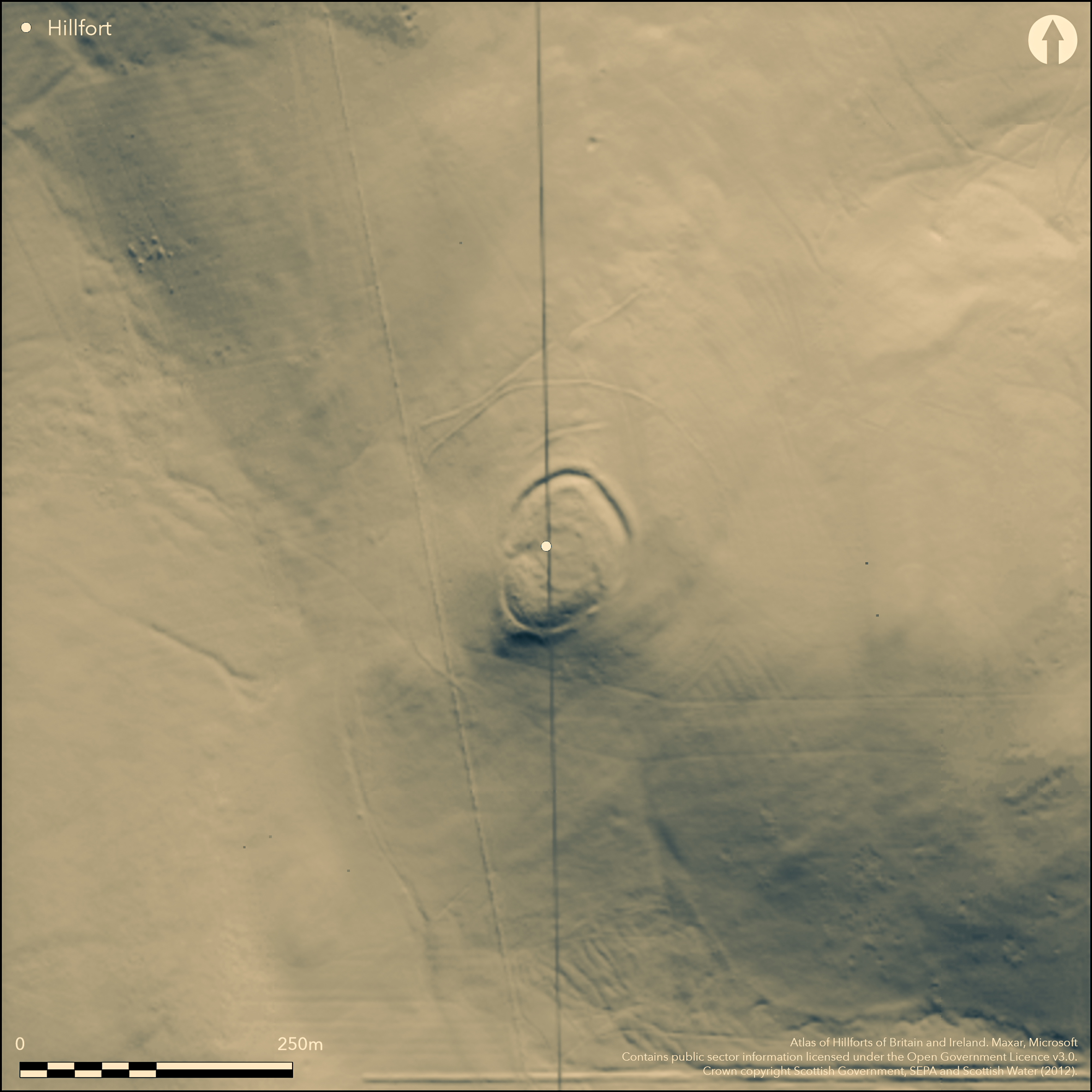
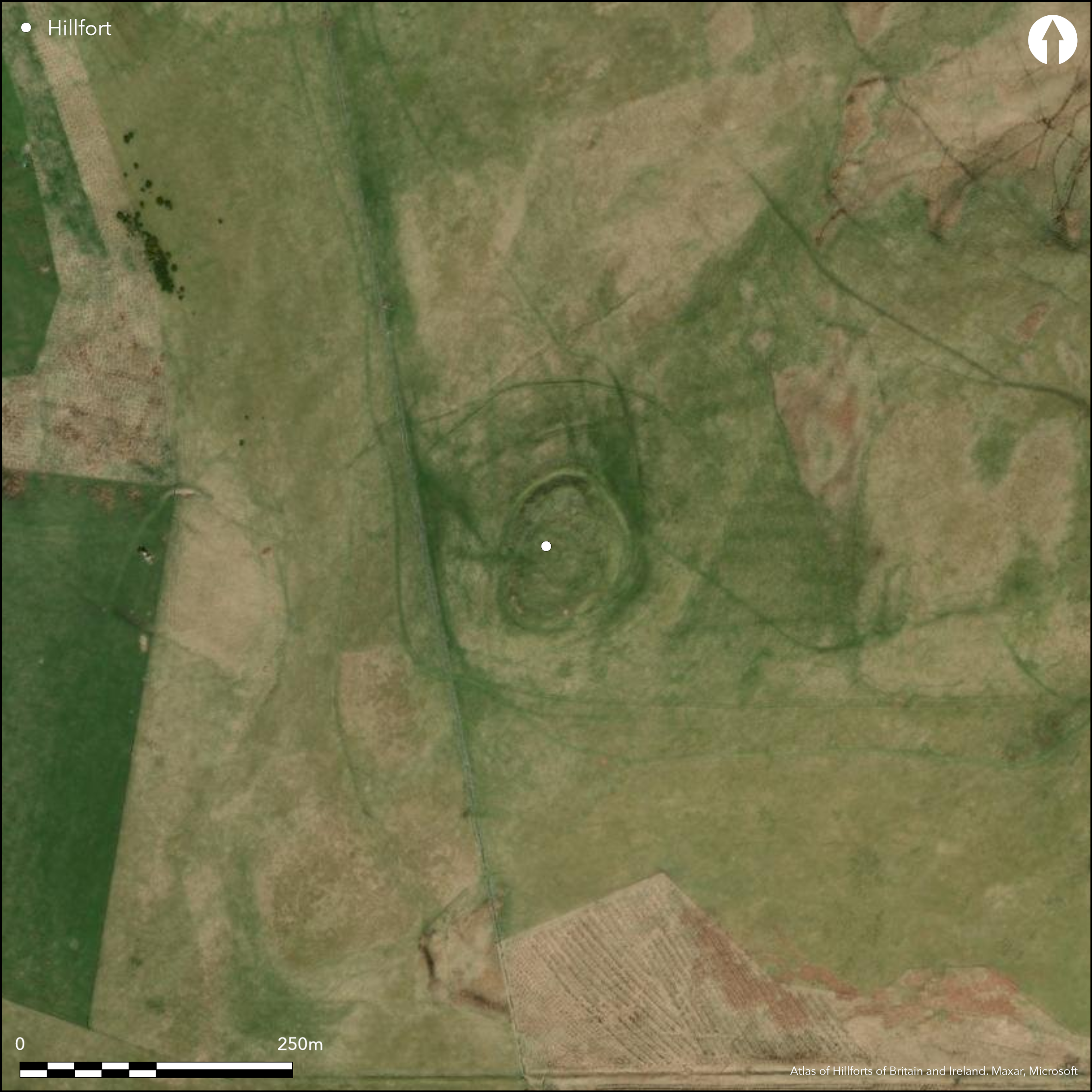
A heavily degraded fort is situated on the summit of Langlaw Hill, which forms the highest point of a long ridge flanking the W side of the valley taken by the A701 public road N of Broughton. Oval on plan, it measures at least 60m from NNE to SSW by 38m transversely within twin ramparts with a medial ditch, though the inner rampart extending round the margin of the summit has been reduced to no more than a scarp, on the N dropping some 3m into the bottom of the ditch. The latter is cut into the foot of the knoll forming the summit and, apart from the entrance on the W and a sector where it appears missing on the SE, the outer rampart is continuous, standing some 1.3m high. At the entrance on the W a well-worn hollow mounts the slope into the interior; what may be a second entrance lies on the SE, coinciding with the broad gap in the ditch and outer rampart. A later enclosure measuring about 30m by 25m within a low stony bank occupies the centre of the interior. In addition to the fort defences, there are several other earthworks in the immediate vicinity which have been interpreted as elements of the defences. The first is a segment of a ditch and bank on the N, which RCAHMS investigators in 1957 suggested was part of an unfinished defence linked to a supposed marker trench on the E. The latter feature, however, is probably no more than a post-medieval plough scar, while traces of the segment of bank and ditch can be traced E down the slope, despite being ploughed down by the post-medieval cultivation. In short any connection between these features and the fort is fortuitous. Likewise a low bank a little further down the slope, which encloses an area of 2.3ha, but though this has been considered an ancient enclosure, it has the appearance of a post-medieval dyke and may yet prove to be a plantation enclosure. The third and final earthwork is a cross-ridge dyke about 60m N of the fort, which is notable for an entrance with staggered terminals to either side of the gap; its date is unknown.
Citizen Science: ✗
Reliability of Data: Confirmed
Reliability of Interpretation: Confirmed
X: -381936 Y: 7484939 (EPSG: 3857)
Longitude: -3.4309888428188744 Latitude: 55.62913916576578 (EPSG:4326)
Country: Scotland
Current County or Unitary Authority: Scottish Borders
Historic County: Peeblesshire
Current Parish/Community/Council/Townland: Broughton, Glenholm And Kilbucho
None
| Extant | ✓ |
| Cropmark | ✗ |
| Likely Destroyed | ✗ |
None
| Woodland | ✗ |
| Commercial Forestry Plantation | ✗ |
| Parkland | ✗ |
| Pasture (Grazing) | ✓ |
| Arable | ✗ |
| Scrub/Bracken | ✗ |
| Bare Outcrop | ✗ |
| Heather/Moorland | ✓ |
| Heath | ✗ |
| Built-up | ✗ |
| Coastal Grassland | ✗ |
| Other | ✗ |
None
| Contour Fort | ✓ |
| Partial Contour Fort | ✗ |
| Promontory Fort | ✗ |
| Hillslope Fort | ✗ |
| Level Terrain Fort | ✗ |
| Marsh Fort | ✗ |
| Multiple Enclosure Fort | ✗ |
| Hilltop | ✓ |
| Coastal Promontory | ✗ |
| Inland Promontory | ✗ |
| Valley Bottom | ✗ |
| Knoll/Hillock/Outcrop | ✗ |
| Ridge | ✗ |
| Cliff/Plateau-edge/Scarp | ✗ |
| Hillslope | ✗ |
| Lowland | ✗ |
| Spur | ✗ |
Dominant Topographic Feature: None
| North | ✗ |
| Northeast | ✗ |
| East | ✗ |
| Southeast | ✗ |
| South | ✗ |
| Southwest | ✗ |
| West | ✗ |
| Northwest | ✗ |
| Level | ✓ |
Altitude: 370.0m
N/A
In the absence of excavation, there are neither stratified artefacts nor radiocarbon dates to provide a chronology for the defences.
Reliability: D - None
| Pre 1200BC | ✗ |
| 1200BC - 800BC | ✗ |
| 800BC - 400BC | ✗ |
| 400BC - AD50 | ✗ |
| AD50 - AD400 | ✗ |
| AD400 - AD 800 | ✗ |
| Post AD800 | ✗ |
| Unknown | ✓ |
| Pre Hillfort: | None |
| Post Hillfort: | The large enclosure surrounding the fort, the Z work on the RCAHMS plan, has all the appearance of a post-medieval dyke, perhaps for a long vanished plantation. |
Photographed by CUCAP in 1969, and by RCAHMS Aerial Survey Programme in 1981 and 1984.
| 1st Identified Map Depiction (1856): | Annotated Fort on the 1st edition OS 25-inch map (Peebles 1859, sheet 11.16) |
| Other (1863): | Description by William Chambers (1864, 30, 35-6) |
| Earthwork Survey (1886): | Sketch-plan and description by David Christison (1887, 58-9, fig 43) |
| Earthwork Survey (1957): | Plan and description (RCAHMS 1967, 128-30, no.300, fig 115; RCAHMS PBD 124/1-3) |
| Other (1964): | Visited by the OS |
| Other (1972): | Scheduled |
| Other (1972): | Resurveyed at 1:2500 by the OS |
| Other (1979): | Visited by the OS |
| Other (2015): | Visited by S Halliday |
Apart from an enclosure on the summit, the interior is featureless
None
| None | ✓ |
| Spring | ✗ |
| Stream | ✗ |
| Pool | ✗ |
| Flush | ✗ |
| Well | ✗ |
| Other | ✗ |
None
| No Known Features | ✓ |
| Round Stone Structures | ✗ |
| Rectangular Stone Structures | ✗ |
| Curvilinear Platforms | ✗ |
| Other Roundhouse Evidence | ✗ |
| Pits | ✗ |
| Quarry Hollows | ✗ |
| Other | ✗ |
None
| No Known Excavation | ✓ |
| Pits | ✗ |
| Postholes | ✗ |
| Roundhouses | ✗ |
| Rectangular Structures | ✗ |
| Roads/Tracks | ✗ |
| Quarry Hollows | ✗ |
| Other | ✗ |
| Nothing Found | ✗ |
None
| No Known Geophysics | ✓ |
| Pits | ✗ |
| Roundhouses | ✗ |
| Rectangular Structures | ✗ |
| Roads/Tracks | ✗ |
| Quarry Hollows | ✗ |
| Other | ✗ |
| Nothing Found | ✗ |
None
| No Known Finds | ✓ |
| Pottery | ✗ |
| Metal | ✗ |
| Metalworking | ✗ |
| Human Bones | ✗ |
| Animal Bones | ✗ |
| Lithics | ✗ |
| Environmental | ✗ |
| Other | ✗ |
NO APPARENT FEATURES
| APs Not Checked | ✗ |
| None | ✓ |
| Roundhouses | ✗ |
| Rectangular Structures | ✗ |
| Pits | ✗ |
| Postholes | ✗ |
| Roads/Tracks | ✗ |
| Other | ✗ |
See main summary
| 3: | Two gaps in the outer defences on the SE |
| 2: | None |
Guard Chambers: ✗
Chevaux de Frise: ✗
| 1. Simple Gap (West): | Worn hollow mounts the slope into the interior |
Twin ramparts with a medial ditch around most of the circuit; an outlying segment of rampart and ditch lies to the N and is supposed to be part of an unfinished circuit, though on the E where it has been ploughed down by post-medieval cultivation, there are traces of it dropping down the slope rather than extending round the contour. The supposed marker trench around the SE quarter is no more than a plough scar relating to the post-medieval cultivation remains, while the outlying enclosure encircling the whole site is also almost certainly of post-medieval date. The linear earthwork cutting across the spine of the ridge on the N, however, is of antiquity and includes a staggered entrance where the terminals are offset to either side of the gap.
| Area 1: | 0.17ha. |
| Total: | 0.17ha. |
Total Footprint Area: 0.54ha.
None
| ✓ | Evidently a later enclosure of relatively slight proportions overlying the interior |
| ✓ | This omits the overlying enclosure within the interior, and the outlying earthwork on the N, the character of which is uncertain |
| NE Quadrant: | 2 |
| SE Quadrant: | 2 |
| SW Quadrant: | 2 |
| NW Quadrant: | 2 |
| Total: | 2 |
| Partial Univallate | ✗ |
| Univallate | ✗ |
| Partial Bivallate | ✗ |
| Bivallate | ✓ |
| Partial Multivallate | ✗ |
| Multivallate | ✗ |
| Unknown | ✗ |
| Partial Univallate | ✗ |
| Univallate | ✗ |
| Partial Bivallate | ✗ |
| Bivallate | ✗ |
| Partial Multivallate | ✗ |
| Multivallate | ✗ |
Claims of a marker trench for an unfinished defence have been made here, but the trench appears to be no more than an old plough scar
| None | ✗ |
| Earthen Bank | ✓ |
| Stone Wall | ✗ |
| Rubble | ✗ |
| Wall-walk | ✗ |
| Evidence of Timber | ✗ |
| Vitrification | ✗ |
| Other Burning | ✗ |
| Palisade | ✗ |
| Counter Scarp Bank | ✗ |
| Berm | ✗ |
| Unfinished | ✓ |
| Other | ✗ |
None
| None | ✗ |
| Earthen Bank | ✗ |
| Stone Wall | ✗ |
| Murus Duplex | ✗ |
| Timber-framed | ✗ |
| Timber-laced | ✗ |
| Vitrification | ✗ |
| Other Burning | ✗ |
| Palisade | ✗ |
| Counter Scarp Bank | ✗ |
| Berm | ✗ |
| Unfinished | ✗ |
| No Known Excavation | ✓ |
| Other | ✗ |
| ✗ | None |
| ✓ | None |
Number of Ditches: 1
| ✗ | None |
Chambers, W (1864) A History of Peeblessire. William and Robert Chambers: Edinburgh and London
Christison, D (1887) 'The prehistoric forts of Peeblesshire'. Proc Soc Antiq Scot 21 (1886-7), 13-82
RCAHMS (1967) The Royal Commission on the Ancient and Historical Monuments of Scotland. Peeblesshire: an inventory of the ancient monuments, 2v. HMSO: Edinburgh
Atlas of Hillforts:
Wikidata:
This work is licensed under CC BY-SA 4.0![]()
![]()
![]() and should be cited as:
and should be cited as:
Lock, Gary and Ralston, Ian. 2024. Atlas of Hillforts of Britain and Ireland. Available at: https://hillforts.arch.ox.ac.uk
Document Version 1.1