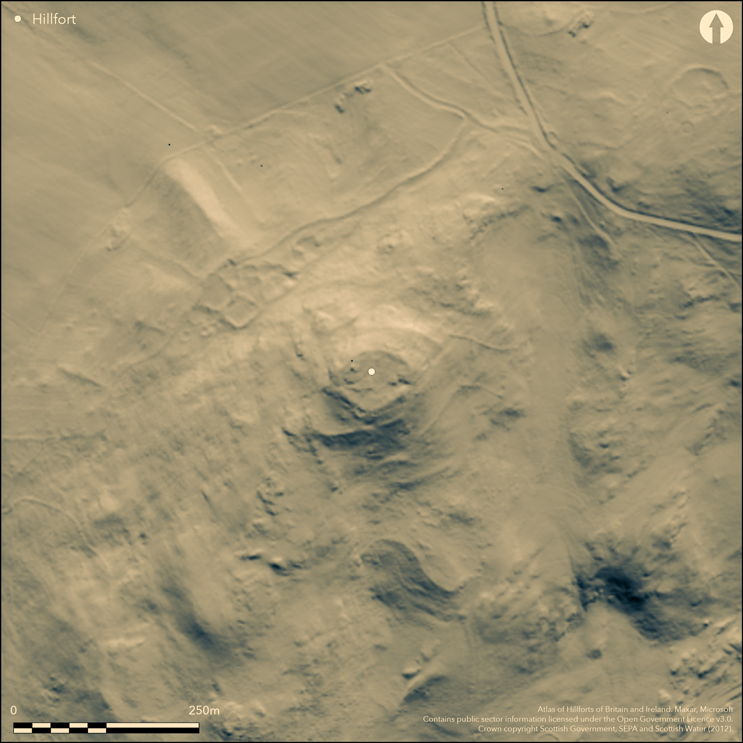
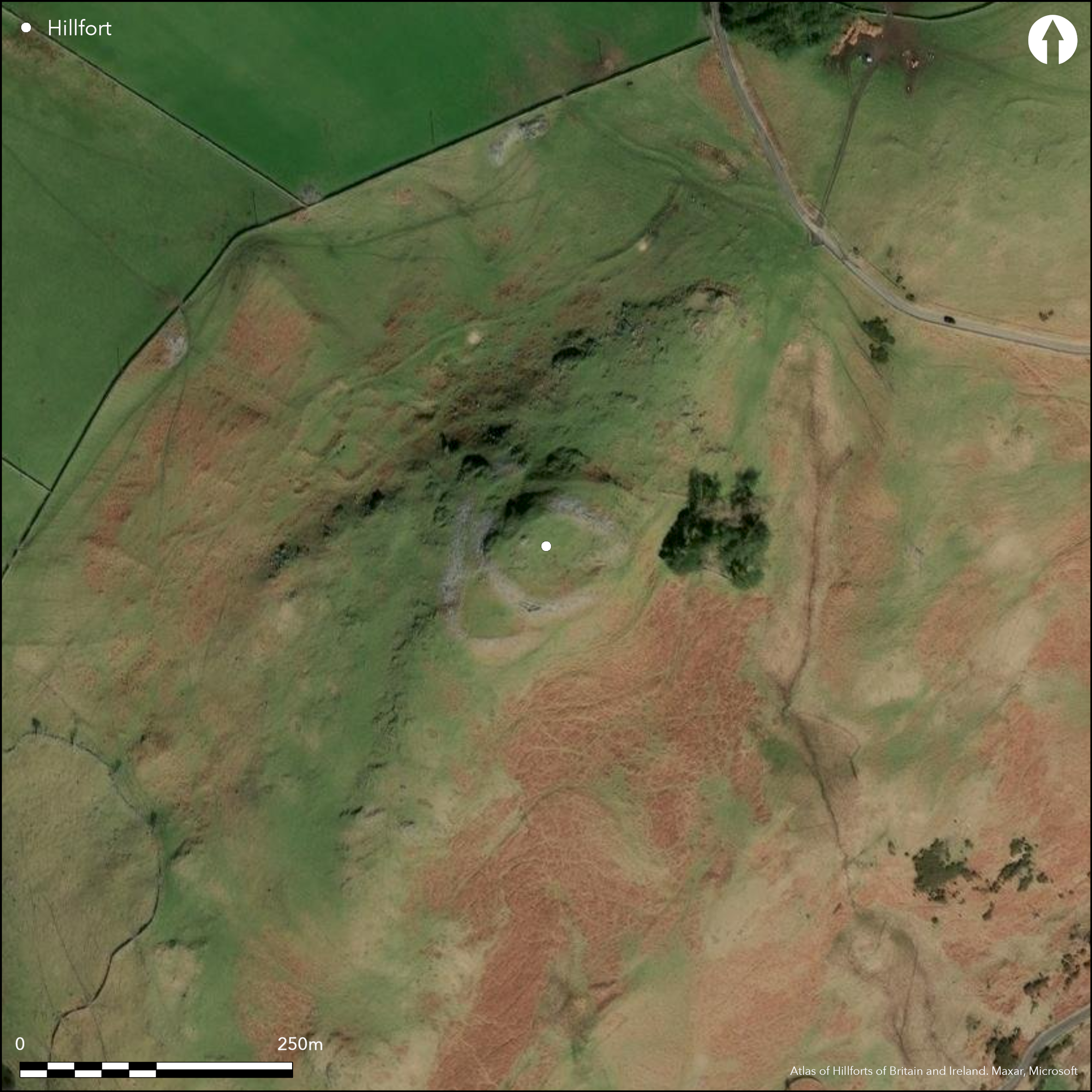
LiDAR 1m DTM Hillshade
Satellite Imagery
LiDAR 1m DTM Hillshade
Satellite Imagery
Scroll left/right to view further images.
HER: Scottish Borders 49881 (None)
NMR: NT 13 NW 8 (49881)
SM: 2895
NGR: NT 1267 3533
X: 312670 Y: 635330 (OSGB36)
This fort crowns the rocky summit of Dreva Craig, which forms the SW spur of Dreva Hill. The defences comprise two walls, which follow eccentric courses, the inner crowning the summit area, and the outer extending round a lower terrace, and there are have also been belts of chevaux de frise set out across the easiest lines of approach on the NE and SW. The inner enclosure, which has the appearance of a citadel, is oval on plan and measures about 56m from E to W by 43m transversely (0.18ha) within a massive wall between 3.6m and 4.3m in thickness; on the WNW the wall has completely collapsed down the slope, but elsewhere portions of the faces are visible, particularly on the SW, which has suffered from misguided attempts at rebuilding. At least three stone-founded round-houses are visible within the interior, though these need not be contemporary with the defences. The entrance is on the E, adapting a cleft in the rocks from below which a natural ramp descends towards the NE, presumably making for a gap in the outer wall, though little trace of it survives in this sector. The outer enclosure is roughly rhomboidal on plan, measuring a maximum of 115m from NE to SW by 85m transversely (0.64ha), and in addition to the entrance described above, which lies at its NE apex, there is also a second on the NNW where the terminals of the wall overlap to expose the visitor's left side. Unlike the other entrance, which gives access to the inner enclosure, this entrance only serves the outer and is possibly evidence that it was originally conceived as a separate defensive scheme. The belts of chevaux de frise are set across the approaches to this lower wall. That on the SW is the better preserved, the stones having been partly cleared on the NE to make way for a later settlement of stone-walled round-houses and enclosed yards. Evidently later than the fort defences, this is just one of a number of other settlements on the hill, including an extensive cluster of scooped courts and yards associated with a field-system extending along the NW flank of the hill.
Citizen Science: ✗
Reliability of Data: Confirmed
Reliability of Interpretation: Confirmed
X: -377115 Y: 7479936 (EPSG: 3857)
Longitude: -3.387682263120695 Latitude: 55.603755930943564 (EPSG:4326)
Country: Scotland
Current County or Unitary Authority: Scottish Borders
Historic County: Peeblesshire
Current Parish/Community/Council/Townland: Stobo
None
| Extant | ✓ |
| Cropmark | ✗ |
| Likely Destroyed | ✗ |
None
| Woodland | ✗ |
| Commercial Forestry Plantation | ✗ |
| Parkland | ✗ |
| Pasture (Grazing) | ✓ |
| Arable | ✗ |
| Scrub/Bracken | ✓ |
| Bare Outcrop | ✗ |
| Heather/Moorland | ✓ |
| Heath | ✗ |
| Built-up | ✗ |
| Coastal Grassland | ✗ |
| Other | ✗ |
None
| Contour Fort | ✓ |
| Partial Contour Fort | ✗ |
| Promontory Fort | ✗ |
| Hillslope Fort | ✗ |
| Level Terrain Fort | ✗ |
| Marsh Fort | ✗ |
| Multiple Enclosure Fort | ✗ |
| Hilltop | ✓ |
| Coastal Promontory | ✗ |
| Inland Promontory | ✗ |
| Valley Bottom | ✗ |
| Knoll/Hillock/Outcrop | ✗ |
| Ridge | ✗ |
| Cliff/Plateau-edge/Scarp | ✗ |
| Hillslope | ✗ |
| Lowland | ✗ |
| Spur | ✗ |
Dominant Topographic Feature: None
| North | ✗ |
| Northeast | ✗ |
| East | ✗ |
| Southeast | ✗ |
| South | ✗ |
| Southwest | ✗ |
| West | ✗ |
| Northwest | ✗ |
| Level | ✓ |
Altitude: 276.0m
N/A
In the absence of excavation, there are neither stratified artefacts nor radiocarbon dates to provide a chronology for the defences.
Reliability: D - None
| Pre 1200BC | ✗ |
| 1200BC - 800BC | ✗ |
| 800BC - 400BC | ✗ |
| 400BC - AD50 | ✗ |
| AD50 - AD400 | ✗ |
| AD400 - AD 800 | ✗ |
| Post AD800 | ✗ |
| Unknown | ✓ |
| Pre Hillfort: | None |
| Post Hillfort: | The outer rampart is overlain by what is probably a later fold at the SW end |
Photographed by CUCAP in 1964 and 1971, and RCAHMS Aerial Survey Programme in 1981, 1984, 2001, 2002 and 2010
| 1st Identified Map Depiction (1856): | Annotated Fort on the 1st edition OS 25-inch map (Peebles16.1) |
| Other (1864): | Listed by William Chambers (1864, 30) |
| Earthwork Survey (1886): | Sketch-plan and description by David Christison (1887, 22-5, fig 6) |
| Earthwork Survey (1958): | Plan and description (RCAHMS 1967, 111-14, no.275, fig 91; RCAHMS PBD 101/1-12) |
| Other (1964): | Visited by the OS |
| Other (1969): | Scheduled |
| Other (1974): | Revised at 1:2500 by the OS |
| Other (1976): | Visited by the Hill-fort Study Group |
Six stone-founded round-houses identified by RCAHMS investigators in 1958, but only three or four are well-defined structures
None
| None | ✓ |
| Spring | ✗ |
| Stream | ✗ |
| Pool | ✗ |
| Flush | ✗ |
| Well | ✗ |
| Other | ✗ |
None
| No Known Features | ✗ |
| Round Stone Structures | ✓ |
| Rectangular Stone Structures | ✗ |
| Curvilinear Platforms | ✗ |
| Other Roundhouse Evidence | ✗ |
| Pits | ✗ |
| Quarry Hollows | ✗ |
| Other | ✗ |
None
| No Known Excavation | ✓ |
| Pits | ✗ |
| Postholes | ✗ |
| Roundhouses | ✗ |
| Rectangular Structures | ✗ |
| Roads/Tracks | ✗ |
| Quarry Hollows | ✗ |
| Other | ✗ |
| Nothing Found | ✗ |
None
| No Known Geophysics | ✓ |
| Pits | ✗ |
| Roundhouses | ✗ |
| Rectangular Structures | ✗ |
| Roads/Tracks | ✗ |
| Quarry Hollows | ✗ |
| Other | ✗ |
| Nothing Found | ✗ |
None
| No Known Finds | ✓ |
| Pottery | ✗ |
| Metal | ✗ |
| Metalworking | ✗ |
| Human Bones | ✗ |
| Animal Bones | ✗ |
| Lithics | ✗ |
| Environmental | ✗ |
| Other | ✗ |
NO APPARENT FEATURES
| APs Not Checked | ✗ |
| None | ✓ |
| Roundhouses | ✗ |
| Rectangular Structures | ✗ |
| Pits | ✗ |
| Postholes | ✗ |
| Roads/Tracks | ✗ |
| Other | ✗ |
See main summary
| 2: | None |
| 2: | None |
Guard Chambers: ✗
Chevaux de Frise: ✓
| 1. Simple Gap (East): | Into the inner enclosure and presumably approached along the margin of the spur from the NE |
| 2. Over-lapping (North): | Through outer wall. Oblique approach exposing left side |
| 2. Oblique (North): | None |
Two stone walls
| Area 1: | 0.18ha. |
| Area 2: | 0.64ha. |
| Total: | 0.64ha. |
Total Footprint Area: 0.8ha.
None
| ✗ | None |
| ✓ | None |
| NE Quadrant: | 2 |
| SE Quadrant: | 1 |
| SW Quadrant: | 2 |
| NW Quadrant: | 2 |
| Total: | 2 |
| Partial Univallate | ✓ |
| Univallate | ✗ |
| Partial Bivallate | ✓ |
| Bivallate | ✗ |
| Partial Multivallate | ✗ |
| Multivallate | ✗ |
| Unknown | ✗ |
| Partial Univallate | ✗ |
| Univallate | ✗ |
| Partial Bivallate | ✗ |
| Bivallate | ✗ |
| Partial Multivallate | ✗ |
| Multivallate | ✗ |
None
| None | ✗ |
| Earthen Bank | ✗ |
| Stone Wall | ✓ |
| Rubble | ✗ |
| Wall-walk | ✗ |
| Evidence of Timber | ✗ |
| Vitrification | ✗ |
| Other Burning | ✗ |
| Palisade | ✗ |
| Counter Scarp Bank | ✗ |
| Berm | ✗ |
| Unfinished | ✗ |
| Other | ✗ |
None
| None | ✗ |
| Earthen Bank | ✗ |
| Stone Wall | ✗ |
| Murus Duplex | ✗ |
| Timber-framed | ✗ |
| Timber-laced | ✗ |
| Vitrification | ✗ |
| Other Burning | ✗ |
| Palisade | ✗ |
| Counter Scarp Bank | ✗ |
| Berm | ✗ |
| Unfinished | ✗ |
| No Known Excavation | ✓ |
| Other | ✗ |
| ✗ | None |
| ✗ | None |
Number of Ditches: None
| ✗ | None |
Chambers, W (1864) A History of Peeblessire. William and Robert Chambers: Edinburgh and London
Christison, D (1887) 'The prehistoric forts of Peeblesshire'. Proc Soc Antiq Scot 21 (1886-7), 13-82
RCAHMS (1967) The Royal Commission on the Ancient and Historical Monuments of Scotland. Peeblesshire: an inventory of the ancient monuments, 2v. HMSO: Edinburgh
Atlas of Hillforts:
Wikidata:
This work is licensed under CC BY-SA 4.0![]()
![]()
![]() and should be cited as:
and should be cited as:
Lock, Gary and Ralston, Ian. 2024. Atlas of Hillforts of Britain and Ireland. Available at: https://hillforts.arch.ox.ac.uk
Document Version 1.1