Satellite Imagery
Satellite Imagery
HER: Scottish Borders 49856 (None)
NMR: NT 13 NW 10 (49856)
SM: 2945
NGR: NT 1098 3532
X: 310980 Y: 635320 (OSGB36)
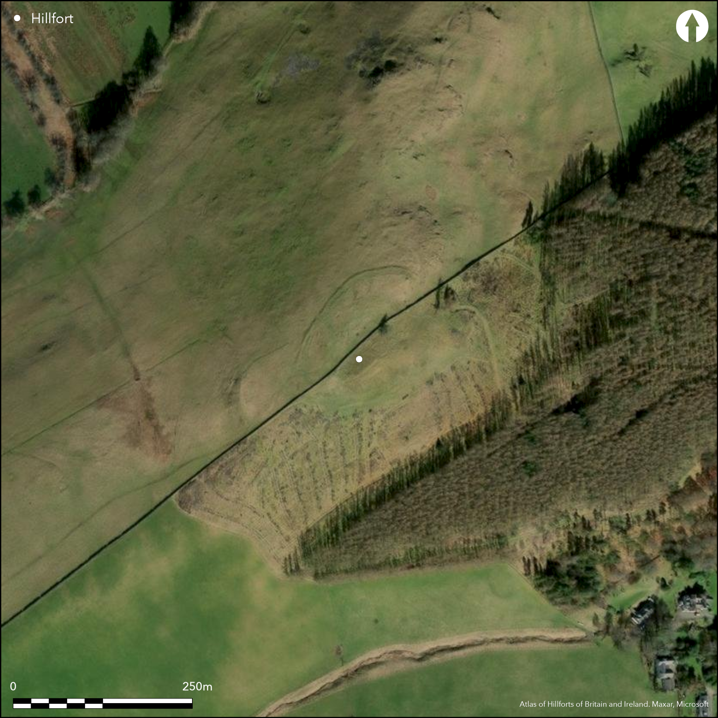
The summit of Helm End is enclosed by a fort which displays at least two periods of construction. The earlier comprises a rampart and external ditch, though the latter is barely visible round the N and W half of the circuit and entirely obscured in the fringes of the forestry plantation on the S and E. The area enclosed is an irregular shape, partly to conform to the contours around the N flank of the summit, and measures about 105m from NE to SW by 85m transversely (0.9ha), and there are entrances on the WSW and ESE. Both the latter were apparently reused in a subsequent phase, when the earlier rampart was replaced with a wall. Now heavily robbed and reduced to a band of rubble no more than 3m thick; this follows the same line as the earlier rampart around the N part of the circuit, but is set a little to its rear around the S. Within the interior, there are traces of an inner enclosure, also bounded by little more than a band of rubble and enclosing a roughly sub-rectangular area measuring about 65m from NE to SW by 50m transversely. It has a single entrance on the SW, adopted by the stone dyke that traverses the fort from NE to SW, and within its interior there are six stone-founded round-houses, one of which was excavated in 1962, revealing four buttresses around the inner wall-face and a ring of post-holes that may have belonged to an earlier building on the same spot (RCAHMS 1967, 120-1, no.286). No dating evidence was recovered, but in the opinion of the RCAHMS investigators who carried out the work, the stone-founded round-houses and the inner and outer walls related to a single phase settlement overlying the earlier fort; they may equally well be successive. Apart from the post-ring and an area of paving beneath the round-house wall, the only evidence of occupation possibly associated with the fort are the backs of two house-platforms cut into the slope outside the inner enclosure on the NW.
Citizen Science: ✗
Reliability of Data: Confirmed
Reliability of Interpretation: Confirmed
X: -380100 Y: 7479858 (EPSG: 3857)
Longitude: -3.4144941769978674 Latitude: 55.60335972485974 (EPSG:4326)
Country: Scotland
Current County or Unitary Authority: Scottish Borders
Historic County: Peeblesshire
Current Parish/Community/Council/Townland: Broughton, Glenholm And Kilbucho
None
| Extant | ✓ |
| Cropmark | ✗ |
| Likely Destroyed | ✗ |
The SE half lies in a clearing in a forestry plantation and is heavily infested with bracken
| Woodland | ✗ |
| Commercial Forestry Plantation | ✓ |
| Parkland | ✗ |
| Pasture (Grazing) | ✓ |
| Arable | ✗ |
| Scrub/Bracken | ✓ |
| Bare Outcrop | ✗ |
| Heather/Moorland | ✓ |
| Heath | ✗ |
| Built-up | ✗ |
| Coastal Grassland | ✗ |
| Other | ✗ |
None
| Contour Fort | ✓ |
| Partial Contour Fort | ✗ |
| Promontory Fort | ✗ |
| Hillslope Fort | ✗ |
| Level Terrain Fort | ✗ |
| Marsh Fort | ✗ |
| Multiple Enclosure Fort | ✓ |
| Hilltop | ✓ |
| Coastal Promontory | ✗ |
| Inland Promontory | ✗ |
| Valley Bottom | ✗ |
| Knoll/Hillock/Outcrop | ✗ |
| Ridge | ✗ |
| Cliff/Plateau-edge/Scarp | ✗ |
| Hillslope | ✗ |
| Lowland | ✗ |
| Spur | ✗ |
Dominant Topographic Feature: None
| North | ✗ |
| Northeast | ✗ |
| East | ✗ |
| Southeast | ✗ |
| South | ✗ |
| Southwest | ✗ |
| West | ✗ |
| Northwest | ✗ |
| Level | ✓ |
Altitude: 325.0m
N/A
There are neither stratified artefacts nor radiocarbon dates to provide a chronology for the defences.
Reliability: D - None
| Pre 1200BC | ✗ |
| 1200BC - 800BC | ✗ |
| 800BC - 400BC | ✗ |
| 400BC - AD50 | ✗ |
| AD50 - AD400 | ✗ |
| AD400 - AD 800 | ✗ |
| Post AD800 | ✗ |
| Unknown | ✓ |
| Pre Hillfort: | None |
| Post Hillfort: | Overridden by a stone dyke and subsequently incorporated into a plantation in a clearing on the SE side of the dyke |
Photographed by RCAHMS Aerial Survey Programme in 1981
| 1st Identified Map Depiction (1856): | Annotated Fort on the 1st edition OS 25-inch map (Peebles 1859, sheet 15.4) |
| Other (1864): | Listed by William Chambers (1864, 30) |
| Earthwork Survey (1886): | Sketch-plan and description by David Christison (1887, 62-3, pl 5, fig 66) |
| Earthwork Survey (1962): | Plan and description (RCAHMS 1967, 120-1, no.286, fig 103; RCAHMS PBD 112/1-7) |
| Excavation (1962): | Of one of the round-houses by Richard Feachem (Archive drawings held amongst RCAHMS plans cited above) |
| Other (1964): | Visited by the OS |
| Other (1971): | Scheduled |
| Other (1974): | Visited by the OS |
| Other (2002): | Re-Scheduled |
| Other (2013): | Visited by S Halliday |
Six stone-founded round-houses are visible within the inner enclosure, one of which was excavated by Richard Feachem, and the backs of two house-platforms have been identified outside it on the NW.
None
| None | ✓ |
| Spring | ✗ |
| Stream | ✗ |
| Pool | ✗ |
| Flush | ✗ |
| Well | ✗ |
| Other | ✗ |
None
| No Known Features | ✗ |
| Round Stone Structures | ✓ |
| Rectangular Stone Structures | ✗ |
| Curvilinear Platforms | ✗ |
| Other Roundhouse Evidence | ✗ |
| Pits | ✗ |
| Quarry Hollows | ✗ |
| Other | ✗ |
A single round-house was excavated, revealing four low butresses round the inner face of the wall and a slightly eccentric ring of post-holes, though these and paving beneath the wall on the S were assigned to an earlier phase of construction.
| No Known Excavation | ✗ |
| Pits | ✗ |
| Postholes | ✓ |
| Roundhouses | ✓ |
| Rectangular Structures | ✗ |
| Roads/Tracks | ✗ |
| Quarry Hollows | ✗ |
| Other | ✓ |
| Nothing Found | ✗ |
None
| No Known Geophysics | ✓ |
| Pits | ✗ |
| Roundhouses | ✗ |
| Rectangular Structures | ✗ |
| Roads/Tracks | ✗ |
| Quarry Hollows | ✗ |
| Other | ✗ |
| Nothing Found | ✗ |
The only finds from the excavation were fragments of the upper stones of two rotary querns and a small saddle quern.
| No Known Finds | ✗ |
| Pottery | ✗ |
| Metal | ✗ |
| Metalworking | ✗ |
| Human Bones | ✗ |
| Animal Bones | ✗ |
| Lithics | ✗ |
| Environmental | ✗ |
| Other | ✓ |
NO APPARENT FEATURES
| APs Not Checked | ✗ |
| None | ✗ |
| Roundhouses | ✓ |
| Rectangular Structures | ✗ |
| Pits | ✗ |
| Postholes | ✗ |
| Roads/Tracks | ✗ |
| Other | ✗ |
See main summary
| 2: | None |
| 2: | None |
Guard Chambers: ✗
Chevaux de Frise: ✗
| 1. Simple Gap (East): | None |
| 2. Simple Gap (South west): | None |
An outer enclosure is formed by two successive lines, the earlier a rampart and ditch, and the later a robbed wall, while an inner enclosure is defined by another robbed wall. A linear earthwork also cuts across the ridge to the SW, though its line has been obscured by post-medieval boundaries
| Area 1: | 0.25ha. |
| Area 2: | 0.9ha. |
| Total: | 0.9ha. |
Total Footprint Area: Noneha.
None
| ✗ | None |
| ✓ | None |
| NE Quadrant: | 3 |
| SE Quadrant: | 3 |
| SW Quadrant: | 3 |
| NW Quadrant: | 3 |
| Total: | 3 |
| Partial Univallate | ✗ |
| Univallate | ✗ |
| Partial Bivallate | ✗ |
| Bivallate | ✗ |
| Partial Multivallate | ✗ |
| Multivallate | ✓ |
| Unknown | ✗ |
| Partial Univallate | ✗ |
| Univallate | ✓ |
| Partial Bivallate | ✗ |
| Bivallate | ✓ |
| Partial Multivallate | ✗ |
| Multivallate | ✗ |
None
| None | ✗ |
| Earthen Bank | ✓ |
| Stone Wall | ✗ |
| Rubble | ✓ |
| Wall-walk | ✗ |
| Evidence of Timber | ✗ |
| Vitrification | ✗ |
| Other Burning | ✗ |
| Palisade | ✗ |
| Counter Scarp Bank | ✗ |
| Berm | ✗ |
| Unfinished | ✗ |
| Other | ✗ |
Excavation focused on a round-house within the interior
| None | ✗ |
| Earthen Bank | ✗ |
| Stone Wall | ✗ |
| Murus Duplex | ✗ |
| Timber-framed | ✗ |
| Timber-laced | ✗ |
| Vitrification | ✗ |
| Other Burning | ✗ |
| Palisade | ✗ |
| Counter Scarp Bank | ✗ |
| Berm | ✗ |
| Unfinished | ✗ |
| No Known Excavation | ✗ |
| Other | ✓ |
| ✗ | None |
| ✓ | None |
Number of Ditches: 1
| ✗ | None |
Chambers, W (1864) A History of Peeblessire. William and Robert Chambers: Edinburgh and London
Christison, D (1887) 'The prehistoric forts of Peeblesshire'. Proc Soc Antiq Scot 21 (1886-7), 13-82
RCAHMS (1967) The Royal Commission on the Ancient and Historical Monuments of Scotland. Peeblesshire: an inventory of the ancient monuments, 2v. HMSO: Edinburgh
Atlas of Hillforts:
Wikidata:
This work is licensed under CC BY-SA 4.0![]()
![]()
![]() and should be cited as:
and should be cited as:
Lock, Gary and Ralston, Ian. 2024. Atlas of Hillforts of Britain and Ireland. Available at: https://hillforts.arch.ox.ac.uk
Document Version 1.1