LiDAR 1m DTM Hillshade
Satellite Imagery
LiDAR 1m DTM Hillshade
Satellite Imagery
Scroll left/right to view further images.
HER: Scottish Borders 49989 (None)
NMR: NT 14 NE 7 (49989)
SM: 2955
NGR: NT 1680 4607
X: 316800 Y: 646070 (OSGB36)
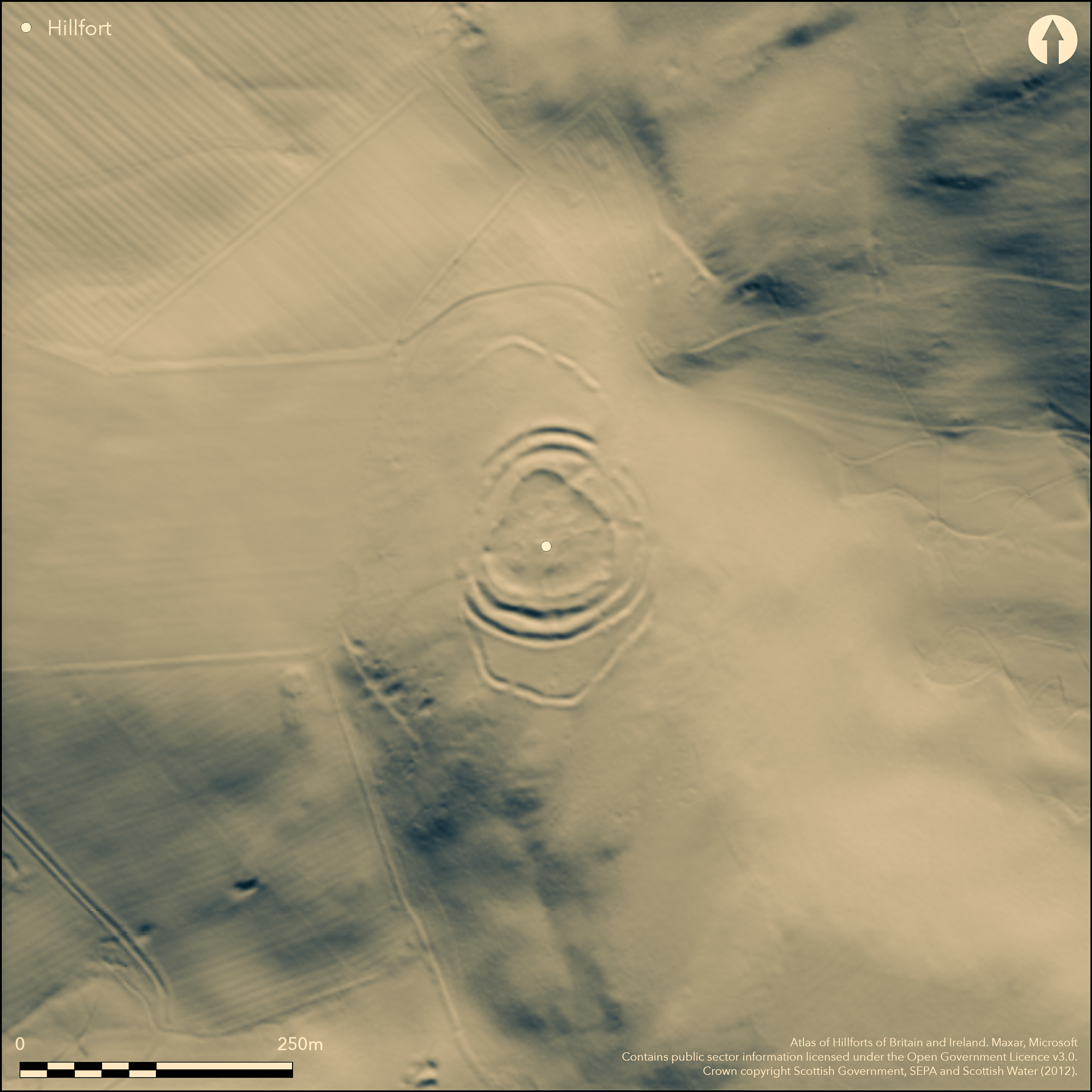
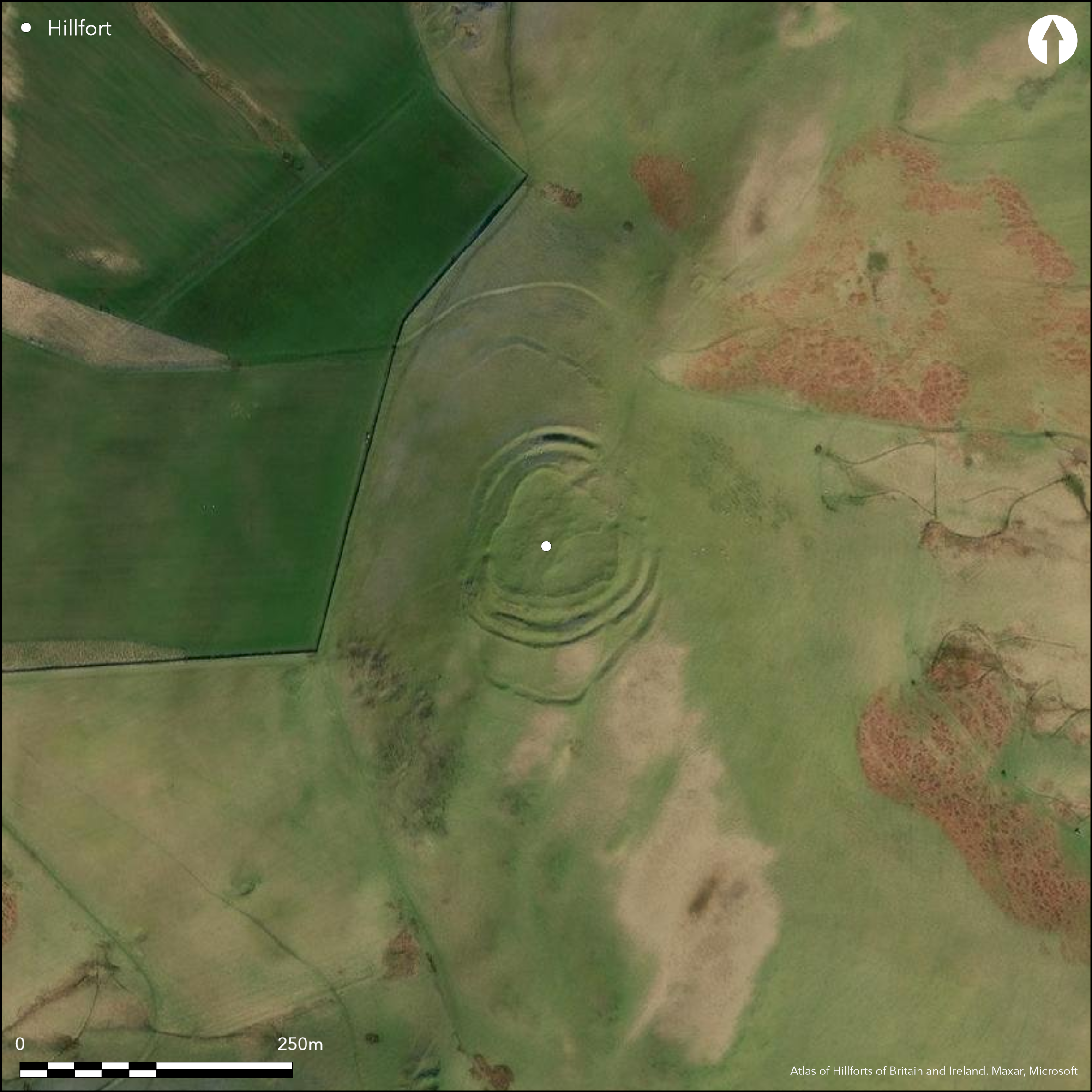
This fort occupies the N end of the broad summit area of Whiteside Hill, dominating the slope dropping down into the saddle that links the hill to the White Knowe on the ridge to the NNE. Oval on plan the fort measures 73m from NNE to SSW by 61m transversely within three ramparts with intermediate ditches forming a multivallate belt in excess of 20m deep. In drawing up a plan in 1959, however, RCAHMS investigators postulated that this belt represented two periods of construction, in which the two outer ramparts and a medial ditch were added to an originally univallate circuit comprising the inner rampart and the inner ditch. Their reasoning lay with the four entrances they identified, on the NNE, NE, E and WSW respectively, and in particular that through the inner rampart on the NNE, which appeared to be blocked by the medial rampart outside it. It should be noted, however, that this whole sector of the defences is more heavily degraded than anywhere on the rest of the circuit, including the inner rampart, which was evidently demolished in antiquity prior to the construction of a later enclosure within the interior. Thus, while their observation may be correct, the explanation may be more complex, and they do not account for why the earlier gap was left unblocked in the inner line of defence of the multivallate scheme. In their view the entrance into the multivallate fort was reconstructed a little further round on the NE, with an oblique approach that exposes the visitor's right side, matching the design of the entrance on the WSW. The entrance on the E, they contended, was inserted through the earlier defences to serve the later enclosure constructed within the interior, which also reused the WSW entrance. The perimeter of this enclosure, which has been reduced to a grass-grown bank of rubble, is set to the rear of the inner rampart on the NE and S, but clearly overlies its line on the ESE and WNW, enclosing an irregular area measuring 63m from NNE to SSW by 60m transversely (0.3ha); the SE side was subsequently adapted into the perimeter of a smaller enclosure. Within the larger enclosure there are at least ten probable crescentic scarps denoting the backs of house platforms, but it is uncertain to which phase of construction any of them belong. In addition to the core multivallate defences, there are outlying earthworks on both the N and the S that have been described as annexes, though that on the N, apparently with an entrance gap on the N, is entirely open along its W side and certainly does not form a complete enclosure. The S annexe comprises an irregular ditch with an external bank enclosing 0.14ha; it is just as likely to be the remains of an earlier hilltop enclosure, possibly unfinished, as a subsidiary enclosure of the fort. on the opposite side of the saddle to the NNE there is also a short cross-ridge-dyke, though whether it is associated with the fort is unknown.
Citizen Science: ✓
Reliability of Data: Confirmed
Reliability of Interpretation: Confirmed
X: -370182 Y: 7499114 (EPSG: 3857)
Longitude: -3.32540507832045 Latitude: 55.700957138749324 (EPSG:4326)
Country: Scotland
Current County or Unitary Authority: Scottish Borders
Historic County: Peeblesshire
Current Parish/Community/Council/Townland: Newlands
None
| Extant | ✓ |
| Cropmark | ✗ |
| Likely Destroyed | ✗ |
None
| Woodland | ✗ |
| Commercial Forestry Plantation | ✗ |
| Parkland | ✗ |
| Pasture (Grazing) | ✓ |
| Arable | ✗ |
| Scrub/Bracken | ✗ |
| Bare Outcrop | ✗ |
| Heather/Moorland | ✓ |
| Heath | ✗ |
| Built-up | ✗ |
| Coastal Grassland | ✗ |
| Other | ✗ |
None
| Contour Fort | ✓ |
| Partial Contour Fort | ✗ |
| Promontory Fort | ✗ |
| Hillslope Fort | ✗ |
| Level Terrain Fort | ✗ |
| Marsh Fort | ✗ |
| Multiple Enclosure Fort | ✗ |
| Hilltop | ✓ |
| Coastal Promontory | ✗ |
| Inland Promontory | ✗ |
| Valley Bottom | ✗ |
| Knoll/Hillock/Outcrop | ✗ |
| Ridge | ✗ |
| Cliff/Plateau-edge/Scarp | ✗ |
| Hillslope | ✗ |
| Lowland | ✗ |
| Spur | ✗ |
Dominant Topographic Feature: None
| North | ✗ |
| Northeast | ✗ |
| East | ✗ |
| Southeast | ✗ |
| South | ✗ |
| Southwest | ✗ |
| West | ✗ |
| Northwest | ✗ |
| Level | ✓ |
Altitude: 368.0m
N/A
There is no evidence to support the contention that the enclosure overlying the defences is Dark Age (RCAHMS 1967, 35); it is much more likely to be a late Iron Age settlement, as is the smaller enclosure overlying it.
Reliability: D - None
| Pre 1200BC | ✗ |
| 1200BC - 800BC | ✗ |
| 800BC - 400BC | ✗ |
| 400BC - AD50 | ✗ |
| AD50 - AD400 | ✗ |
| AD400 - AD 800 | ✗ |
| Post AD800 | ✗ |
| Unknown | ✓ |
| Pre Hillfort: | None |
| Post Hillfort: | A non-defensive settlement enclosure has been inserted roughly concentrically into the interior |
Photographed by CUCAP 1969, and by RCAHMS Aerial Survey Programme 1980, 2006, 2009, 2010 and 2012
| 1st Identified Written Reference (1726): | Noted by Alexander Gordon (1726, 115) |
| 1st Identified Map Depiction (1856): | Annotated Fort on the 1st edition OS 25-inch map (Peebles 1856, sheet 8.10 & 11) |
| Other (1863): | Description by William Chambers (1864, 30, 34-5) |
| Earthwork Survey (1886): | Sketch-plan and description by David Christison (1887, 39-42, fig 25) |
| Earthwork Survey (1959): | Plan and description (RCAHMS 1967, 151-3, no.331, fig 144; RCAHMS PBD 152/1-3) |
| Other (1964): | Visited by the OS |
| Other (1970): | Scheduled |
| Other (1975): | Visited by the OS |
The backs of up to ten circular house-platforms are visible, though these may relate to the later settlement rather than the fort.
None
| None | ✓ |
| Spring | ✗ |
| Stream | ✗ |
| Pool | ✗ |
| Flush | ✗ |
| Well | ✗ |
| Other | ✗ |
Up to ten
| No Known Features | ✗ |
| Round Stone Structures | ✗ |
| Rectangular Stone Structures | ✗ |
| Curvilinear Platforms | ✓ |
| Other Roundhouse Evidence | ✗ |
| Pits | ✗ |
| Quarry Hollows | ✗ |
| Other | ✗ |
None
| No Known Excavation | ✓ |
| Pits | ✗ |
| Postholes | ✗ |
| Roundhouses | ✗ |
| Rectangular Structures | ✗ |
| Roads/Tracks | ✗ |
| Quarry Hollows | ✗ |
| Other | ✗ |
| Nothing Found | ✗ |
None
| No Known Geophysics | ✓ |
| Pits | ✗ |
| Roundhouses | ✗ |
| Rectangular Structures | ✗ |
| Roads/Tracks | ✗ |
| Quarry Hollows | ✗ |
| Other | ✗ |
| Nothing Found | ✗ |
None
| No Known Finds | ✓ |
| Pottery | ✗ |
| Metal | ✗ |
| Metalworking | ✗ |
| Human Bones | ✗ |
| Animal Bones | ✗ |
| Lithics | ✗ |
| Environmental | ✗ |
| Other | ✗ |
NO APPARENT FEATURES
| APs Not Checked | ✗ |
| None | ✗ |
| Roundhouses | ✓ |
| Rectangular Structures | ✗ |
| Pits | ✗ |
| Postholes | ✗ |
| Roads/Tracks | ✗ |
| Other | ✗ |
See main summary
| 2: | None |
| 2: | None |
Guard Chambers: ✗
Chevaux de Frise: ✗
| 1. Simple Gap (North east): | In the inner rampart and apparently blocked by the medial rampart |
| 1. Oblique (North east): | Slightly oblique approach exposing the visitor's right side |
| 1. Blocked (North east): | In the inner rampart and apparently blocked by the medial rampart |
| 2. Simple Gap (East): | Supposed to be a subsequent insertion, but might equally well be original |
| 3. Over-lapping (West): | Staggered gaps. Oblique approach exposing right side |
| 3. Oblique (West): | Oblique approach exposing right side |
Three ramparts, with outlying earthworks on the N and S and a later settlement enclosure overlying the interior. A cross-ridge dyke lies on the far side of the saddle to the N.
| Area 1: | 0.4ha. |
| Total: | 0.4ha. |
Total Footprint Area: 2.3ha.
None
| ✓ | Complex multiperiod sequence in which the multivallate defences are overlain by a later settlement enclosure, presumably late Iron Age in date, which is adapted to form a smaller enclosure in a later phase. The phasing of the defences from a univallate to multivallate work is more contentious. The relationship of the outlying works on the N and S to this sequence is unknown, but an unfinished large primary fort may be envisaged.. |
| ✓ | This omits the outlying earthworks on the N and S |
| NE Quadrant: | 3 |
| SE Quadrant: | 3 |
| SW Quadrant: | 3 |
| NW Quadrant: | 3 |
| Total: | 3 |
| Partial Univallate | ✗ |
| Univallate | ✗ |
| Partial Bivallate | ✗ |
| Bivallate | ✗ |
| Partial Multivallate | ✗ |
| Multivallate | ✓ |
| Unknown | ✗ |
| Partial Univallate | ✗ |
| Univallate | ✓ |
| Partial Bivallate | ✗ |
| Bivallate | ✗ |
| Partial Multivallate | ✗ |
| Multivallate | ✗ |
The outer annexes make little sense and are possibly the remains of an incomplete hilltop enclosure
| None | ✗ |
| Earthen Bank | ✓ |
| Stone Wall | ✗ |
| Rubble | ✗ |
| Wall-walk | ✗ |
| Evidence of Timber | ✗ |
| Vitrification | ✗ |
| Other Burning | ✗ |
| Palisade | ✗ |
| Counter Scarp Bank | ✗ |
| Berm | ✗ |
| Unfinished | ✓ |
| Other | ✗ |
None
| None | ✗ |
| Earthen Bank | ✗ |
| Stone Wall | ✗ |
| Murus Duplex | ✗ |
| Timber-framed | ✗ |
| Timber-laced | ✗ |
| Vitrification | ✗ |
| Other Burning | ✗ |
| Palisade | ✗ |
| Counter Scarp Bank | ✗ |
| Berm | ✗ |
| Unfinished | ✗ |
| No Known Excavation | ✓ |
| Other | ✗ |
| ✗ | None |
| ✓ | None |
Number of Ditches: 2
| ✗ | The outlying earthworks on the N and S might be described as annexes, but they are just as likely to represent an earlier unfinished enclosure on the hilltop. |
Chambers, W (1864) A History of Peeblessire. William and Robert Chambers: Edinburgh and London
Christison, D (1887) 'The prehistoric forts of Peeblesshire'. Proc Soc Antiq Scot 21 (1886-7), 13-82
Gordon, A (1726) Itinerarium Septentrionale: or A Journey Thro' most of the Counties of Scotland And Those in the North of England. London
RCAHMS (1967) The Royal Commission on the Ancient and Historical Monuments of Scotland. Peeblesshire: an inventory of the ancient monuments, 2v. HMSO: Edinburgh
Atlas of Hillforts:
Wikidata:
This work is licensed under CC BY-SA 4.0![]()
![]()
![]() and should be cited as:
and should be cited as:
Lock, Gary and Ralston, Ian. 2024. Atlas of Hillforts of Britain and Ireland. Available at: https://hillforts.arch.ox.ac.uk
Document Version 1.1