Satellite Imagery
Satellite Imagery
HER: Scottish Borders 50072 (None)
NMR: NT 14 SE 6 (50072)
SM: 3027
NGR: NT 1752 4091
X: 317520 Y: 640910 (OSGB36)
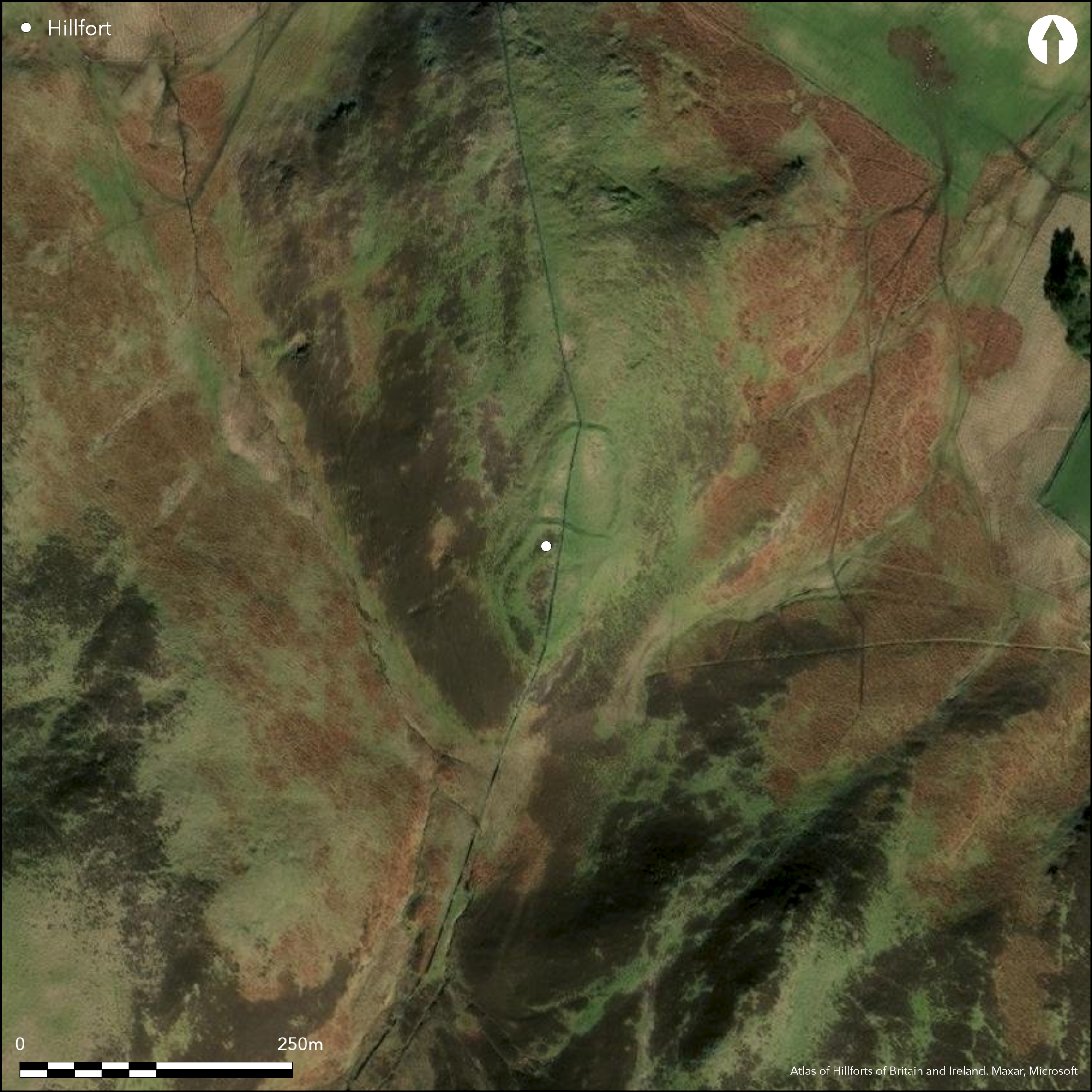
This fort is situated on the rocky spine of Tor Hill, which forms the N spur of Torbank Hill. The S end of the fort dominates the short sharp slope that drops into the saddle separating Tor Hill from the hillside to the S, and certainly blocks access out onto the spur from that direction. Its defences comprise two main elements, namely a bivallate enclosure on the SSW and what has been described as an annexe of 0.15ha with an outer unfinished line of defence added on the NNE. This view of the defences, however, based on the plan drawn up by RCAHMS investigators in 1961, probably telescopes a much more complex sequence of construction which cannot be unravelled without excavation. The inner enclosure at the SSW end, for example, which measures about 47m from NNE to SSW by little more than 27m transversely (0.1ha) within a grass-grown bank of rubble, may well have been inserted into a larger enclosure, reusing the entrance in the outer rampart on the WNW. On the plan, the latter appears to cut back sharply across the spine of the spur on the N, but this too may be an adaptation of an earlier plan, in which the supposed annexe on the NNE and the outer rampart on the SSW formed part of a single sinuous enclosure on the summit, measuring internally some 120m in length by between 35m and 40m in breadth (0.38ha); notably not only is the annexe rampart accompanied by an external ditch, but there are also traces of a ditch outside the outer rampart on the SW. This interpretation would explain why the annexe, which apparently has entrances on the W, E and SE, has no direct link to the interior of the supposedly bivallate fort. Indeed, it is likely that the entrance on the SE, formed against the outer rampart of the bivallate fort, is an original entrance of this larger enclosure, lying midway along the ESE side at a re-entrant in the lip of the natural slope and served by a track that can be faintly detected dropping down to the S. In this rather different interpretation, the significance of the marker trench identified between 10m and 15m outside the annexe on the N and E respectively also changes. Like most other 'marker' trenches in Scotland, it is more likely to have held a timber palisade, which, projected round the contours of the spur may have enclosed an area measuring perhaps as much as 140m from NNE to SSW by up to 55m transversely (0.6ha). No trace of any round-houses can be seen within any of the enclosures on the summit of the spur, but a single timber round-house defined by shallow grooves lies on a terrace at the foot of the slope below the defences on the W.
Citizen Science: ✗
Reliability of Data: Confirmed
Reliability of Interpretation: Confirmed
X: -368735 Y: 7489987 (EPSG: 3857)
Longitude: -3.3123990782958126 Latitude: 55.65472806902385 (EPSG:4326)
Country: Scotland
Current County or Unitary Authority: Scottish Borders
Historic County: Peeblesshire
Current Parish/Community/Council/Townland: Stobo
None
| Extant | ✓ |
| Cropmark | ✗ |
| Likely Destroyed | ✗ |
None
| Woodland | ✗ |
| Commercial Forestry Plantation | ✗ |
| Parkland | ✗ |
| Pasture (Grazing) | ✓ |
| Arable | ✗ |
| Scrub/Bracken | ✗ |
| Bare Outcrop | ✗ |
| Heather/Moorland | ✓ |
| Heath | ✗ |
| Built-up | ✗ |
| Coastal Grassland | ✗ |
| Other | ✗ |
None
| Contour Fort | ✓ |
| Partial Contour Fort | ✗ |
| Promontory Fort | ✗ |
| Hillslope Fort | ✗ |
| Level Terrain Fort | ✗ |
| Marsh Fort | ✗ |
| Multiple Enclosure Fort | ✗ |
| Hilltop | ✓ |
| Coastal Promontory | ✗ |
| Inland Promontory | ✗ |
| Valley Bottom | ✗ |
| Knoll/Hillock/Outcrop | ✗ |
| Ridge | ✗ |
| Cliff/Plateau-edge/Scarp | ✗ |
| Hillslope | ✗ |
| Lowland | ✗ |
| Spur | ✓ |
Dominant Topographic Feature: None
| North | ✗ |
| Northeast | ✗ |
| East | ✗ |
| Southeast | ✗ |
| South | ✗ |
| Southwest | ✗ |
| West | ✗ |
| Northwest | ✗ |
| Level | ✓ |
Altitude: 328.0m
N/A
In the absence of excavation, there are neither stratified artefacts nor radiocarbon dates to provide a chronology for the defences.
Reliability: D - None
| Pre 1200BC | ✗ |
| 1200BC - 800BC | ✗ |
| 800BC - 400BC | ✗ |
| 400BC - AD50 | ✗ |
| AD50 - AD400 | ✗ |
| AD400 - AD 800 | ✗ |
| Post AD800 | ✗ |
| Unknown | ✓ |
| Pre Hillfort: | None |
| Post Hillfort: | Traversed by old stone dyke |
Photographed by RCAHMS Aerial Survey Programme 1980, 1991, 2010
| 1st Identified Map Depiction (1856): | Annotated Forts on the 1st edition OS 25-inch map (Peebles 1859, sheet 12.7) |
| Other (1886): | Description by David Christison (1887,67) |
| Earthwork Survey (1961): | Plan and description (RCAHMS 1967, 144-5, no.322, fig 136; RCAHMS PBD 144/1-2) |
| Other (1961): | Visited by the OS |
| Other (1971): | Scheduled |
| Other (1975): | Resurveyed at 1:2500 by the OS |
| Other (2011): | Visited by S Halliday |
Featureless
None
| None | ✓ |
| Spring | ✗ |
| Stream | ✗ |
| Pool | ✗ |
| Flush | ✗ |
| Well | ✗ |
| Other | ✗ |
None
| No Known Features | ✓ |
| Round Stone Structures | ✗ |
| Rectangular Stone Structures | ✗ |
| Curvilinear Platforms | ✗ |
| Other Roundhouse Evidence | ✗ |
| Pits | ✗ |
| Quarry Hollows | ✗ |
| Other | ✗ |
None
| No Known Excavation | ✓ |
| Pits | ✗ |
| Postholes | ✗ |
| Roundhouses | ✗ |
| Rectangular Structures | ✗ |
| Roads/Tracks | ✗ |
| Quarry Hollows | ✗ |
| Other | ✗ |
| Nothing Found | ✗ |
None
| No Known Geophysics | ✓ |
| Pits | ✗ |
| Roundhouses | ✗ |
| Rectangular Structures | ✗ |
| Roads/Tracks | ✗ |
| Quarry Hollows | ✗ |
| Other | ✗ |
| Nothing Found | ✗ |
None
| No Known Finds | ✓ |
| Pottery | ✗ |
| Metal | ✗ |
| Metalworking | ✗ |
| Human Bones | ✗ |
| Animal Bones | ✗ |
| Lithics | ✗ |
| Environmental | ✗ |
| Other | ✗ |
NO APPARENT FEATURES
| APs Not Checked | ✗ |
| None | ✓ |
| Roundhouses | ✗ |
| Rectangular Structures | ✗ |
| Pits | ✗ |
| Postholes | ✗ |
| Roads/Tracks | ✗ |
| Other | ✗ |
See main summary
| 5: | None |
| 2: | Possibly as many as four in an early phase, but heavily modified subsequently (1, 2, 4 & 5 below). The inner enclosure at the SSW end also has an additional entrance (3) |
Guard Chambers: ✗
Chevaux de Frise: ✗
| 1. Simple Gap (North east): | into the supposed annexe and through the outer palisade/marker trench |
| 2. Simple Gap (East): | At the seam between the supposed annexe and the outer rampart at the SSW end, but possibly an original entrance of a larger fort, approached by a track on the slope |
| 3. Simple Gap (East): | In the inner enclosure, but evidently at an area that has been severely disturbed |
| 4. Simple Gap (South west): | Through both the inner and outer enclosures at the SSW end |
| 5. Simple Gap (North west): | Through the rampart of the supposed annexe |
The most likely interpretation here is of a large timber-built hilltop enclosure of 0.6ha replaced by a fort of 0.38ha, which was subsequently subdivided and had a small settlement of 0.1ha inserted into the SSW end
| Area 1: | 0.1ha. |
| Area 2: | 0.38ha. |
| Area 3: | 0.6ha. |
| Total: | 0.6ha. |
Total Footprint Area: Noneha.
None
| ✓ | But the stratigraphy is not particularly clear-cut |
| ✓ | This omits the small inner enclosure at the SSW end |
| NE Quadrant: | 1 |
| SE Quadrant: | 1 |
| SW Quadrant: | 1 |
| NW Quadrant: | 1 |
| Total: | 1 |
| Partial Univallate | ✗ |
| Univallate | ✓ |
| Partial Bivallate | ✗ |
| Bivallate | ✗ |
| Partial Multivallate | ✗ |
| Multivallate | ✗ |
| Unknown | ✗ |
| Partial Univallate | ✗ |
| Univallate | ✓ |
| Partial Bivallate | ✗ |
| Bivallate | ✗ |
| Partial Multivallate | ✗ |
| Multivallate | ✗ |
Supposedly unfinished, the marker trench is included here as a palisade trench
| None | ✗ |
| Earthen Bank | ✗ |
| Stone Wall | ✗ |
| Rubble | ✓ |
| Wall-walk | ✗ |
| Evidence of Timber | ✗ |
| Vitrification | ✗ |
| Other Burning | ✗ |
| Palisade | ✓ |
| Counter Scarp Bank | ✗ |
| Berm | ✗ |
| Unfinished | ✓ |
| Other | ✗ |
None
| None | ✗ |
| Earthen Bank | ✗ |
| Stone Wall | ✗ |
| Murus Duplex | ✗ |
| Timber-framed | ✗ |
| Timber-laced | ✗ |
| Vitrification | ✗ |
| Other Burning | ✗ |
| Palisade | ✗ |
| Counter Scarp Bank | ✗ |
| Berm | ✗ |
| Unfinished | ✗ |
| No Known Excavation | ✓ |
| Other | ✗ |
| ✗ | None |
| ✓ | None |
Number of Ditches: 1
| ✓ | The conventional interpretation here is of an annexe of some 0.15ha added to a smaller bivallate fort, but it is far more likely that this impression is a product of the way in which an earlier large fort of 0.38ha has been modified and adapted in subsequent periods of occupation. |
Christison, D (1887) 'The prehistoric forts of Peeblesshire'. Proc Soc Antiq Scot 21 (1886-7), 13-82
RCAHMS (1967) The Royal Commission on the Ancient and Historical Monuments of Scotland. Peeblesshire: an inventory of the ancient monuments, 2v. HMSO: Edinburgh
Atlas of Hillforts:
Wikidata:
This work is licensed under CC BY-SA 4.0![]()
![]()
![]() and should be cited as:
and should be cited as:
Lock, Gary and Ralston, Ian. 2024. Atlas of Hillforts of Britain and Ireland. Available at: https://hillforts.arch.ox.ac.uk
Document Version 1.1