Satellite Imagery
Satellite Imagery
HER: Scottish Borders 51390 (None)
NMR: NT 24 NE 1 (51390)
SM: 731
NGR: NT 2572 4934
X: 325720 Y: 649340 (OSGB36)
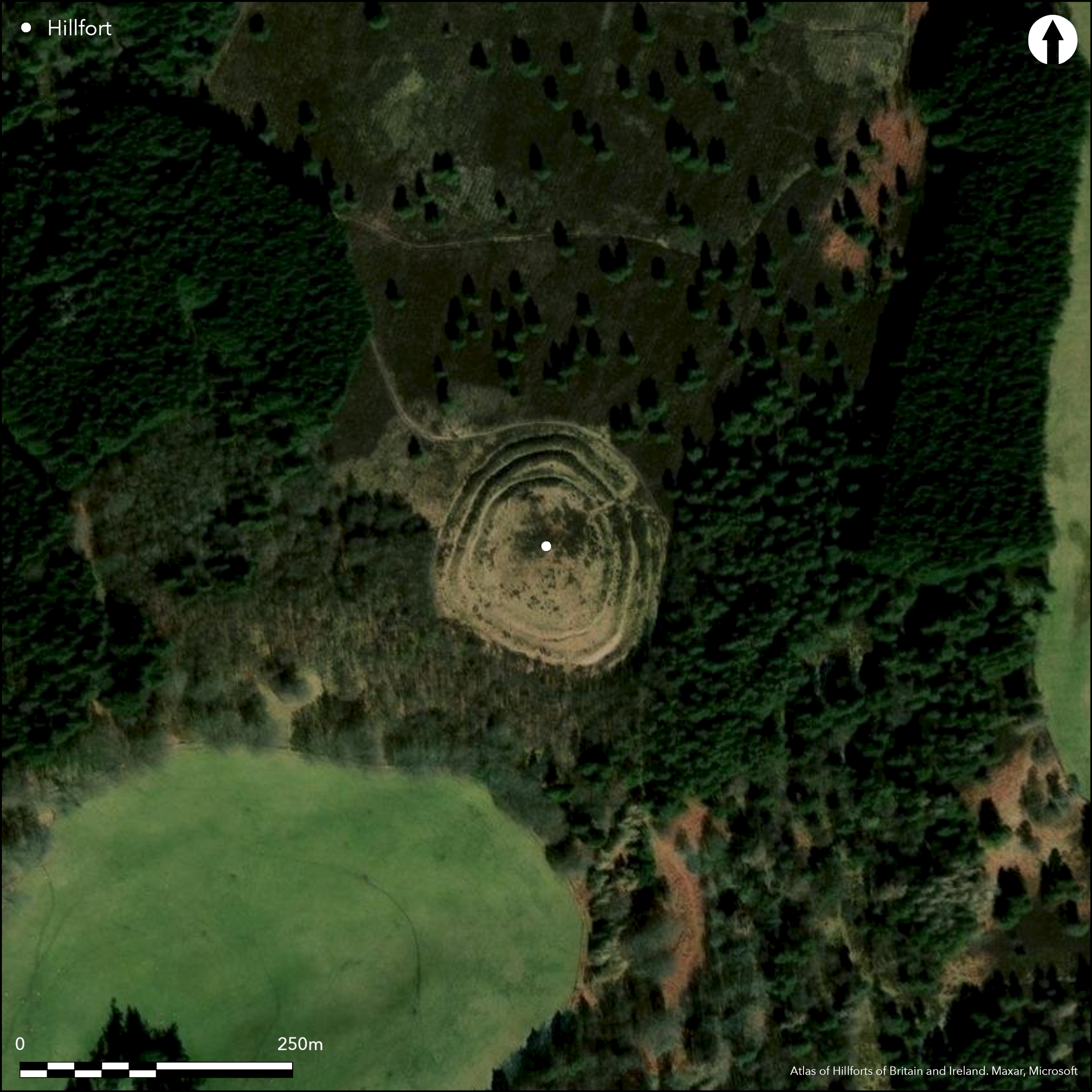
This fort stands on the summit of a rounded hill between Portmore House and Portmore Loch, and having been under trees since the early 19th century is remarkably well preserved, presenting an impressive array of low ramparts and ditches. The defences almost certainly represent at least two periods of construction, but whereas RCAHMS investigators in 1959 opted to see the innermost enclosure as the earlier, subsequently enhanced by the addition of no fewer than three ramparts and intermediate ditches, the reverse is far more likely to be the case; the relationship hinges on the stratigraphy on the W, but this relationship is not clear-cut in the way that it appears upon their plan (RCAHMS 1967, 136-7, no.309, fig 124). The innermost enclosure is oval on plan, measuring 73m from NNW to SSE by 64m transversely (0.35ha) within a rampart that rises no more than 0.5m above the interior and 1.5m above the external ditch; the ditch is some 3m in breadth and accompanied around the NW half of the circuit by a low counterscarp bank, and it is this that is supposedly overlain on the W by the inner rampart of the outer defences. Elsewhere the the space between them forms a strip up to 8m wide, which is a curious feature if the intention had been to add a deep belt of multivallate defences. More likely these latter, which are altogether more substantial than the inner enclosure, are the earlier, forming a belt up to 20m deep and enclosing an area measuring about 100m by 85m transversely (0.6ha). The defences are pierced by entrances at three places, on the NE, S and SW respectively, and at each the gap between the terminal of the ramparts and ditches narrows towards the interior. Each of the entrances has also served the inner enclosure, though this inner entrance is offset to one side of the gap in the outer ramparts, on the NE and SW only slightly, but on the S in gross degree, creating a deep dogleg in the approach. The defences and interior are usually clothed in deep heather, but when the OS revised the 1:2500 depiction in 1971 the vegetation had been burnt off, revealing seven shallow depressions between 6m and 9m in diameter within the inner enclosure, which may mark the stances of timber round-houses.
Citizen Science: ✗
Reliability of Data: Confirmed
Reliability of Interpretation: Confirmed
X: -354486 Y: 7505205 (EPSG: 3857)
Longitude: -3.1843978675603144 Latitude: 55.73178228801882 (EPSG:4326)
Country: Scotland
Current County or Unitary Authority: Scottish Borders
Historic County: Peeblesshire
Current Parish/Community/Council/Townland: Eddleston
None
| Extant | ✓ |
| Cropmark | ✗ |
| Likely Destroyed | ✗ |
Formerly under trees since the early 19th century
| Woodland | ✗ |
| Commercial Forestry Plantation | ✗ |
| Parkland | ✗ |
| Pasture (Grazing) | ✗ |
| Arable | ✗ |
| Scrub/Bracken | ✗ |
| Bare Outcrop | ✗ |
| Heather/Moorland | ✓ |
| Heath | ✗ |
| Built-up | ✗ |
| Coastal Grassland | ✗ |
| Other | ✗ |
None
| Contour Fort | ✓ |
| Partial Contour Fort | ✗ |
| Promontory Fort | ✗ |
| Hillslope Fort | ✗ |
| Level Terrain Fort | ✗ |
| Marsh Fort | ✗ |
| Multiple Enclosure Fort | ✗ |
| Hilltop | ✓ |
| Coastal Promontory | ✗ |
| Inland Promontory | ✗ |
| Valley Bottom | ✗ |
| Knoll/Hillock/Outcrop | ✗ |
| Ridge | ✗ |
| Cliff/Plateau-edge/Scarp | ✗ |
| Hillslope | ✗ |
| Lowland | ✗ |
| Spur | ✗ |
Dominant Topographic Feature: None
| North | ✗ |
| Northeast | ✗ |
| East | ✗ |
| Southeast | ✗ |
| South | ✗ |
| Southwest | ✗ |
| West | ✗ |
| Northwest | ✗ |
| Level | ✓ |
Altitude: 359.0m
N/A
In the absence of excavation, there are neither stratified artefacts nor radiocarbon dates to provide a chronology for the defences.
Reliability: D - None
| Pre 1200BC | ✗ |
| 1200BC - 800BC | ✗ |
| 800BC - 400BC | ✗ |
| 400BC - AD50 | ✗ |
| AD50 - AD400 | ✗ |
| AD400 - AD 800 | ✗ |
| Post AD800 | ✗ |
| Unknown | ✓ |
| Pre Hillfort: | None |
| Post Hillfort: | Planted with trees in the early 19th century |
Photographed by CUCAP in 1980,and by RCAHMS Aerial Survey Programme in 1980, 1982, 1985, 1997, 2005 and 2007
| 1st Identified Map Depiction (1775): | Concentric rings on a hill symbol on Mostyn Armstrong's map of The County of Peebles or Tweedale (1775) |
| Other (1856): | Annotated Fort on the 1st edition OS 25-inch map (Peebles 1858, sheet 6.14) |
| Other (1863): | Listed and description by William Chambers (1864, 29, 31) |
| Earthwork Survey (1886): | Sketch-plan and description by David Christison (1887, 38-9, fig 23) |
| Earthwork Survey (1959): | Plan and description (RCAHMS 1967, 136-7, no.309, fig 124, RCAHMS PBD 132/1 -2) |
| Other (1971): | Scheduled |
| Other (1971): | Revised at 1:2500 by the OS |
The OS visited shortly after the heather had been burnt off and observed seven shallow depressions between 6m and 9m in diameter which they thought probably marked the positions of round-houses
None
| None | ✓ |
| Spring | ✗ |
| Stream | ✗ |
| Pool | ✗ |
| Flush | ✗ |
| Well | ✗ |
| Other | ✗ |
None
| No Known Features | ✗ |
| Round Stone Structures | ✗ |
| Rectangular Stone Structures | ✗ |
| Curvilinear Platforms | ✓ |
| Other Roundhouse Evidence | ✗ |
| Pits | ✗ |
| Quarry Hollows | ✗ |
| Other | ✗ |
None
| No Known Excavation | ✓ |
| Pits | ✗ |
| Postholes | ✗ |
| Roundhouses | ✗ |
| Rectangular Structures | ✗ |
| Roads/Tracks | ✗ |
| Quarry Hollows | ✗ |
| Other | ✗ |
| Nothing Found | ✗ |
None
| No Known Geophysics | ✓ |
| Pits | ✗ |
| Roundhouses | ✗ |
| Rectangular Structures | ✗ |
| Roads/Tracks | ✗ |
| Quarry Hollows | ✗ |
| Other | ✗ |
| Nothing Found | ✗ |
None
| No Known Finds | ✓ |
| Pottery | ✗ |
| Metal | ✗ |
| Metalworking | ✗ |
| Human Bones | ✗ |
| Animal Bones | ✗ |
| Lithics | ✗ |
| Environmental | ✗ |
| Other | ✗ |
NO APPARENT FEATURES
| APs Not Checked | ✗ |
| None | ✓ |
| Roundhouses | ✗ |
| Rectangular Structures | ✗ |
| Pits | ✗ |
| Postholes | ✗ |
| Roads/Tracks | ✗ |
| Other | ✗ |
See main summary
| 3: | None |
| 2: | None |
Guard Chambers: ✗
Chevaux de Frise: ✗
| 1. Simple Gap (North east): | Gaps between the terminals of the outer ramparts and ditches, become progressively narrower towards the interior |
| 1. Oblique (North east): | Gap in the innermost rampart staggered to create an oblique approach exposing the visitor's left side |
| 2. Simple Gap (South): | Gaps between the terminals of the outer ramparts and ditches, becoming progressively narrower towards the interior |
| 2. Oblique (South): | The entrance on the S side of the innermost enclosure is offset to create a dogleg in the approach exposing the visitor's left side. |
| 3. Simple Gap (South west): | Gaps between the terminals of the outer ramparts and ditches become progressively narrower towards the interior |
| 3. Oblique (South west): | Gap in the innermost rampart staggered to create an oblique approach exposing the visitor's left side |
Two ramparts and ditches with an outer counterscarp bank, and probably a later settlement inserted into the interior
| Area 1: | 0.62ha. |
| Total: | 0.62ha. |
Total Footprint Area: 1.3ha.
None
| ✗ | None |
| ✓ | Excludes the settlement lying within the interior, enclosed by a rampart with an external ditch and a counterscarp bank |
| NE Quadrant: | 2 |
| SE Quadrant: | 2 |
| SW Quadrant: | 2 |
| NW Quadrant: | 2 |
| Total: | 2 |
| Partial Univallate | ✗ |
| Univallate | ✗ |
| Partial Bivallate | ✗ |
| Bivallate | ✓ |
| Partial Multivallate | ✗ |
| Multivallate | ✗ |
| Unknown | ✗ |
| Partial Univallate | ✗ |
| Univallate | ✗ |
| Partial Bivallate | ✗ |
| Bivallate | ✗ |
| Partial Multivallate | ✗ |
| Multivallate | ✗ |
The claim that some elements of the outer defences here were unfinished cannot be sustained
| None | ✗ |
| Earthen Bank | ✓ |
| Stone Wall | ✗ |
| Rubble | ✗ |
| Wall-walk | ✗ |
| Evidence of Timber | ✗ |
| Vitrification | ✗ |
| Other Burning | ✗ |
| Palisade | ✗ |
| Counter Scarp Bank | ✓ |
| Berm | ✗ |
| Unfinished | ✓ |
| Other | ✗ |
None
| None | ✗ |
| Earthen Bank | ✗ |
| Stone Wall | ✗ |
| Murus Duplex | ✗ |
| Timber-framed | ✗ |
| Timber-laced | ✗ |
| Vitrification | ✗ |
| Other Burning | ✗ |
| Palisade | ✗ |
| Counter Scarp Bank | ✗ |
| Berm | ✗ |
| Unfinished | ✗ |
| No Known Excavation | ✓ |
| Other | ✗ |
| ✗ | None |
| ✓ | Excludes the ditch of the settlement within the interior |
Number of Ditches: 2
| ✗ | None |
Chambers, W (1864) A History of Peeblesshire. William and Robert Chambers: Edinburgh and London
Christison, D (1887) 'The prehistoric forts of Peeblesshire'. Proc Soc Antiq Scot 21 (1886-7), 13-82
RCAHMS (1967) The Royal Commission on the Ancient and Historical Monuments of Scotland. Peeblesshire: an inventory of the ancient monuments, 2v. HMSO: Edinburgh
Atlas of Hillforts:
Wikidata:
This work is licensed under CC BY-SA 4.0![]()
![]()
![]() and should be cited as:
and should be cited as:
Lock, Gary and Ralston, Ian. 2024. Atlas of Hillforts of Britain and Ireland. Available at: https://hillforts.arch.ox.ac.uk
Document Version 1.1