LiDAR 1m DTM Hillshade
Satellite Imagery
LiDAR 1m DTM Hillshade
Satellite Imagery
Scroll left/right to view further images.
HER: Scottish Borders 51433 (None)
NMR: NT 24 NW 4 (51433)
SM: 2416
NGR: NT 2480 4595
X: 324800 Y: 645950 (OSGB36)
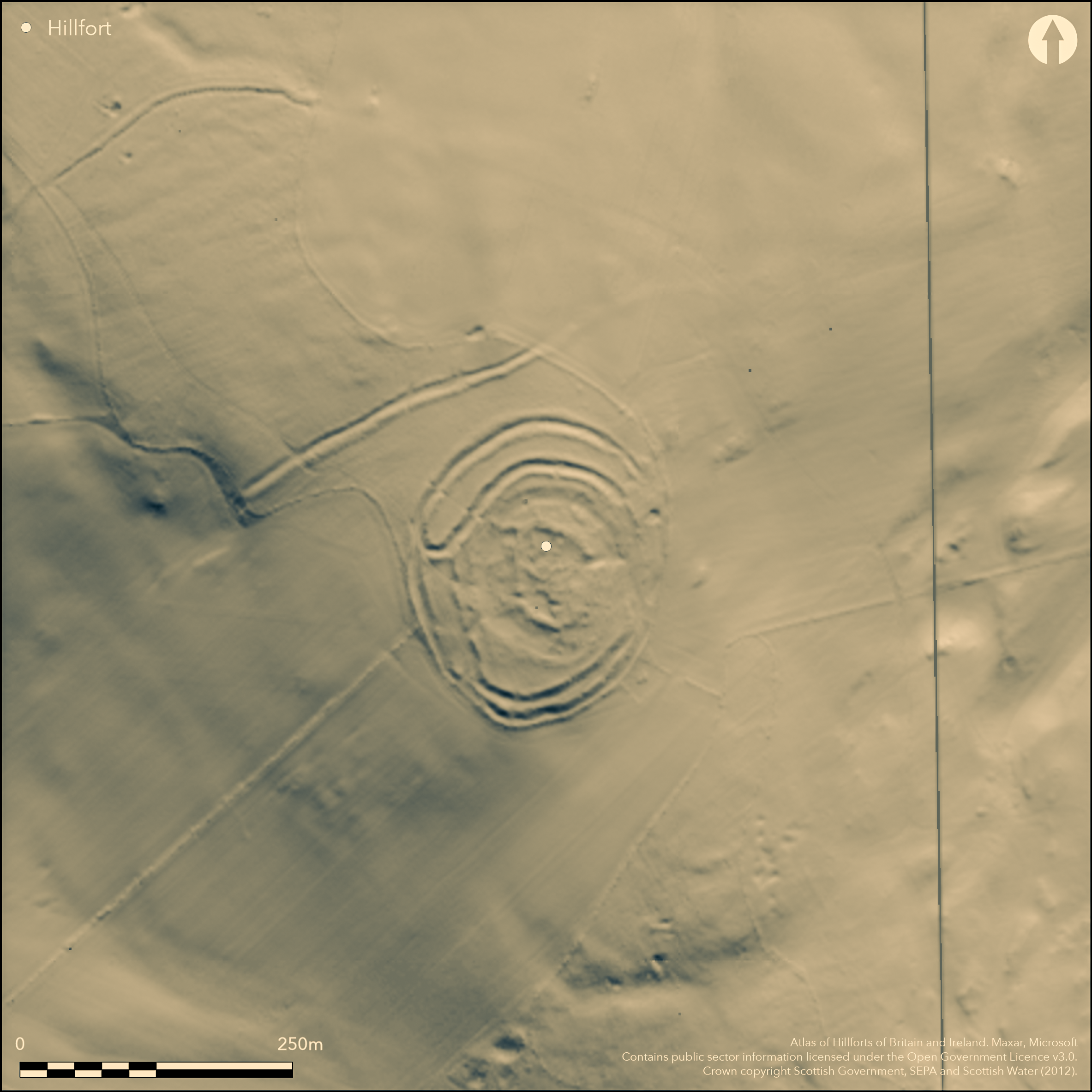
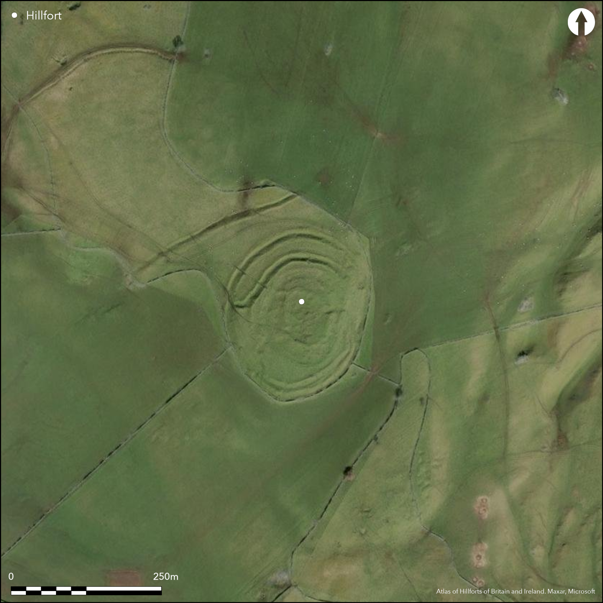
This fort is situated on the summit of Milkieston Hill, which was taken into a series of decorative plantations in the early 19th century but is now under rough pasture. The fort itself, however, has been heavily quarried and robbed of stone, so much so that the evidently complex sequence has been rendered almost incomprehensible, and while the threefold sequence proposed by RCAHMS investigators in 1959 (RCAHMS 1967, 131-3, no.304, fig 118) cannot be entirely correct, its simplification by the OS into two phases has failed to observe several nuances in the surviving remains. What can be beyond doubt Is that there are two inner enclosures, though whether contemporary circuits as assumed by both the RCAHMS investigators and the OS is not clear, and two outer circuits. Contrary to the OS view, these represent at least two periods of construction, demonstrated at the E entrance and on the SSE, but the RCAHMS investigators are mistaken in their observation of the stratigraphical relationship between the innermost of the outer ramparts and the outer circuit of the inner enclosures, and indeed in showing the second phase ditch cutting on the same line as the inner of their phase three ramparts at the entrance on the NE. Furthermore, their suggestion that both their phase 2 and phase 3 schemes were left unfinished, fails to take into account not only the impact on the appearance of the surviving remains of relatively recent quarrying and stone-robbing, but also of demolition in antiquity. For the purposes of description, the fortifications are best separated into the two inner circuits, and the three or four outer ones. The innermost enclosure has been devastated by the later disruption, which has reduced its rampart to at best a grass-grown mound of rubble and round most of the circuit a ragged stony scarp enclosing an area measuring about 49m from NNW to SSE by 37m transversely (0.13ha). It now has one entrance on the E and a second on the SW, though the latter opens into an area of internal quarrying and is likely to be later, and in the surviving part of the interior there are two probably house-platforms and a low stony ring-bank, this last probably overlying the ruined rampart on the N. The second rampart, pursuing a roughly concentric course around the inner enclosure, has been equally heavily robbed, at best forming a low spread mound of rubble. There is no reason why this should not have been a free-standing enclosure taking in a much larger area measuring about 88m from NNW to SSE by 73m transversely (0.51ha); it too has entrances on the E and SW, and in this case both are likely to be original. This circuit was almost certainly reduced to its present state in antiquity, for in it robbed form that it is apparently overlain by the innermost rampart of the outer enclosure on the NW, which itself can be seen overriding an earlier configuration of these outer defences on the W. This scheme had no fewer than four ramparts around the N half, flanking two wide-spaced medial ditches some 4m in breadth by 1.8m in depth, the whole system returning and uniting on what must have been the N side of a major entrance on the W. Of the other side of this entrance, not a trace is visible, and though this led the RCAHMS investigators to suggest the scheme was unfinished, the area to the S shows every sign of heavy disturbance. A second entrance lay on the NE, but it is unclear if the ramparts and ditches ever returned and united here in the same way, despite the depiction by the first OS surveyors in 1856, and it is apparently blocked by another short length of rampart. The character of the defences on the S, nominally relating to a later scheme on the strength of the sequence where the innermost blocks the entrance on the W, is very different, comprising a belt of three close-set ramparts with intermediate ditches; traces of an earlier defence on this line can be seen between the inner and middle of these ramparts on the SSE. There are apparently entrances through the outer ditch on the ESE and SSW, at each of which there are traces of the outer rampart uniting with the middle rampart on one side of the entrance, but in each case the middle rampart carries on across the gap, and if original features the entrance way must have doglegged, on the ESE to expose the visitor's left side, and on the SSW the right side, at the latter making for a gap in the innermost of the three on the SW. Despite the evident complexity of these defences, the enclosure they form measures 110m from N to S by 85m transversely (0.74ha).
Citizen Science: ✗
Reliability of Data: Confirmed
Reliability of Interpretation: Confirmed
X: -356012 Y: 7499159 (EPSG: 3857)
Longitude: -3.198111828063727 Latitude: 55.70118677492238 (EPSG:4326)
Country: Scotland
Current County or Unitary Authority: Scottish Borders
Historic County: Peeblesshire
Current Parish/Community/Council/Townland: Eddleston
None
| Extant | ✓ |
| Cropmark | ✗ |
| Likely Destroyed | ✗ |
None
| Woodland | ✗ |
| Commercial Forestry Plantation | ✗ |
| Parkland | ✗ |
| Pasture (Grazing) | ✓ |
| Arable | ✗ |
| Scrub/Bracken | ✗ |
| Bare Outcrop | ✗ |
| Heather/Moorland | ✓ |
| Heath | ✗ |
| Built-up | ✗ |
| Coastal Grassland | ✗ |
| Other | ✗ |
None
| Contour Fort | ✓ |
| Partial Contour Fort | ✗ |
| Promontory Fort | ✗ |
| Hillslope Fort | ✗ |
| Level Terrain Fort | ✗ |
| Marsh Fort | ✗ |
| Multiple Enclosure Fort | ✗ |
| Hilltop | ✓ |
| Coastal Promontory | ✗ |
| Inland Promontory | ✗ |
| Valley Bottom | ✗ |
| Knoll/Hillock/Outcrop | ✗ |
| Ridge | ✗ |
| Cliff/Plateau-edge/Scarp | ✗ |
| Hillslope | ✗ |
| Lowland | ✗ |
| Spur | ✗ |
Dominant Topographic Feature: None
| North | ✗ |
| Northeast | ✗ |
| East | ✗ |
| Southeast | ✗ |
| South | ✗ |
| Southwest | ✗ |
| West | ✗ |
| Northwest | ✗ |
| Level | ✓ |
Altitude: 339.0m
N/A
In the absence of modern excavation, there are neither stratified artefacts nor radiocarbon dates to provide a chronology for the defences.
Reliability: D - None
| Pre 1200BC | ✗ |
| 1200BC - 800BC | ✗ |
| 800BC - 400BC | ✗ |
| 400BC - AD50 | ✗ |
| AD50 - AD400 | ✗ |
| AD400 - AD 800 | ✗ |
| Post AD800 | ✗ |
| Unknown | ✓ |
| Pre Hillfort: | None |
| Post Hillfort: | Heavy robbing, quarrying and tree planting in the 19th century |
Photographed by CUCAP in 1962, and RCAHMS Aerial Survey Programme in 1980, 1981, 1982, 1984, 2005, 2007 and 2009
| 1st Identified Map Depiction (1775): | Concentric rings on a hilltop symbol on Mostyn Armstrong's map of The County of Peebles or Tweedale (1775) |
| Other (1856): | Annotated Fort on the 1st edition OS 25-inch map (Peebles 1859, sheet 9.10) |
| Earthwork Survey (1863): | Woefully poor sketch-plans by William Chambers (1864, 29, 31-4, figs 9-10) |
| Excavation (1863): | By William Chambers within the interior (1864, 33) |
| Earthwork Survey (1886): | Sketch-plan and description by David Christison (1887, 46-8, fig 32) |
| Earthwork Survey (1959): | Plan and description (RCAHMS 1967, 131-3, no.304, figs 118-19; PBD 127/1-3) |
| Other (1964): | Scheduled |
| Other (1971): | Resurveyed at 1:2500 by the OS |
Various scoops an at least one stony ring-bank overlying the ruined perimeter of the innermost enclosure on the N, but the interior, like the defences has been heavily distorted by stone robbing, quarrying and tree planting.
None
| None | ✓ |
| Spring | ✗ |
| Stream | ✗ |
| Pool | ✗ |
| Flush | ✗ |
| Well | ✗ |
| Other | ✗ |
At least one circular stony bank and two scoops within the innermost enclosure that may be house-platforms
| No Known Features | ✗ |
| Round Stone Structures | ✓ |
| Rectangular Stone Structures | ✗ |
| Curvilinear Platforms | ✓ |
| Other Roundhouse Evidence | ✗ |
| Pits | ✗ |
| Quarry Hollows | ✗ |
| Other | ✗ |
Cryptic description by William Chambers 'lay bare the imperfect foundations of two buildings of stone without mortar, each measuring about 32 feet in length.' (1864, 33)
| No Known Excavation | ✗ |
| Pits | ✗ |
| Postholes | ✗ |
| Roundhouses | ✗ |
| Rectangular Structures | ✗ |
| Roads/Tracks | ✗ |
| Quarry Hollows | ✗ |
| Other | ✓ |
| Nothing Found | ✗ |
None
| No Known Geophysics | ✓ |
| Pits | ✗ |
| Roundhouses | ✗ |
| Rectangular Structures | ✗ |
| Roads/Tracks | ✗ |
| Quarry Hollows | ✗ |
| Other | ✗ |
| Nothing Found | ✗ |
None
| No Known Finds | ✓ |
| Pottery | ✗ |
| Metal | ✗ |
| Metalworking | ✗ |
| Human Bones | ✗ |
| Animal Bones | ✗ |
| Lithics | ✗ |
| Environmental | ✗ |
| Other | ✗ |
NO APPARENT FEATURES
| APs Not Checked | ✓ |
| None | ✗ |
| Roundhouses | ✗ |
| Rectangular Structures | ✗ |
| Pits | ✗ |
| Postholes | ✗ |
| Roads/Tracks | ✗ |
| Other | ✗ |
See main summary
| 6: | None |
| 2: | Spread across various lines of defence and representing several periods |
Guard Chambers: ✗
Chevaux de Frise: ✗
| 1. Simple Gap (North east): | Though no longer surviving the 1st edition OS 25-inch map shows the ditch returning and uniting on the N side of the gap in the outer defences |
| 2. Oblique (East): | Staggered gaps. Oblique approach exposing left side |
| 3. Other Forms (South east): | Through the outer ditch, and traces of the ramparts returning and uniting around the ditch terminal on the S side of the gap |
| 4. Other Forms (South west): | Through the outer ditch, and traces of the ramparts returning and uniting around the ditch terminal on the E side of the gap |
| 5. Simple Gap (South west): | Through the inner ramparts and possibly the outer ramparts, dog-legging down to entrance 4 |
| 5. Oblique (South west): | Oblique approach exposing the right side |
| 6. Passage-way/Corridor (West): | The earlier phase of the outer ramparts return and unite on the N side of what has evidently been an entrance, though there is no trace of the S side. |
A relatively small inner circuit is encircled by a second robbed rampart, which is overlain by the inner of the best preserved sector of the defences on the NW; this outer scheme comprises three or four ramparts and two ditches and is evidently of several periods of construction. In addition a linear earthwork cuts across the spur on the NW, and their is a system of other earthworks, including some flanked by pits lower down the slope.
| Area 1: | 0.13ha. |
| Area 2: | 0.51ha. |
| Area 3: | 0.74ha. |
| Total: | 0.74ha. |
Total Footprint Area: 1.7ha.
None
| ✓ | Evidence of several stratigraphic sequences, but the remains are too heavily disturbed to be entirely certain of their significance in the overall sequence. Comparison with other forts, for example, suggest that the innermost enclosure is likely to be a later insertion, but this cannot be demonstrated here. |
| ✓ | None |
| NE Quadrant: | 5 |
| SE Quadrant: | 5 |
| SW Quadrant: | 4 |
| NW Quadrant: | 6 |
| Total: | 6 |
| Partial Univallate | ✗ |
| Univallate | ✗ |
| Partial Bivallate | ✗ |
| Bivallate | ✗ |
| Partial Multivallate | ✗ |
| Multivallate | ✓ |
| Unknown | ✗ |
| Partial Univallate | ✗ |
| Univallate | ✓ |
| Partial Bivallate | ✗ |
| Bivallate | ✗ |
| Partial Multivallate | ✗ |
| Multivallate | ✓ |
The idea that elements of the defences may be unfinished here, may be based on a misunderstanding of the scale of subsequent demolition and alteration
| None | ✗ |
| Earthen Bank | ✓ |
| Stone Wall | ✗ |
| Rubble | ✓ |
| Wall-walk | ✗ |
| Evidence of Timber | ✗ |
| Vitrification | ✗ |
| Other Burning | ✗ |
| Palisade | ✗ |
| Counter Scarp Bank | ✗ |
| Berm | ✗ |
| Unfinished | ✓ |
| Other | ✗ |
Antiquarian excavation apparently restricted to the interior
| None | ✗ |
| Earthen Bank | ✗ |
| Stone Wall | ✗ |
| Murus Duplex | ✗ |
| Timber-framed | ✗ |
| Timber-laced | ✗ |
| Vitrification | ✗ |
| Other Burning | ✗ |
| Palisade | ✗ |
| Counter Scarp Bank | ✗ |
| Berm | ✗ |
| Unfinished | ✗ |
| No Known Excavation | ✗ |
| Other | ✓ |
| ✗ | None |
| ✓ | None |
Number of Ditches: 2
| ✗ | None |
Chambers, W (1864) A History of Peeblesshire. William and Robert Chambers: Edinburgh and London
Christison, D (1887) 'The prehistoric forts of Peeblesshire'. Proc Soc Antiq Scot 21 (1886-7), 13-82
RCAHMS (1967) The Royal Commission on the Ancient and Historical Monuments of Scotland. Peeblesshire: an inventory of the ancient monuments, 2v. HMSO: Edinburgh
Atlas of Hillforts:
Wikidata:
This work is licensed under CC BY-SA 4.0![]()
![]()
![]() and should be cited as:
and should be cited as:
Lock, Gary and Ralston, Ian. 2024. Atlas of Hillforts of Britain and Ireland. Available at: https://hillforts.arch.ox.ac.uk
Document Version 1.1