LiDAR 1m DTM Hillshade
Satellite Imagery
LiDAR 1m DTM Hillshade
Satellite Imagery
Scroll left/right to view further images.
HER: Scottish Borders 53148 (None)
NMR: NT 33 NW 3 (53148)
SM: 2954
NGR: NT 3020 3727
X: 330200 Y: 637270 (OSGB36)
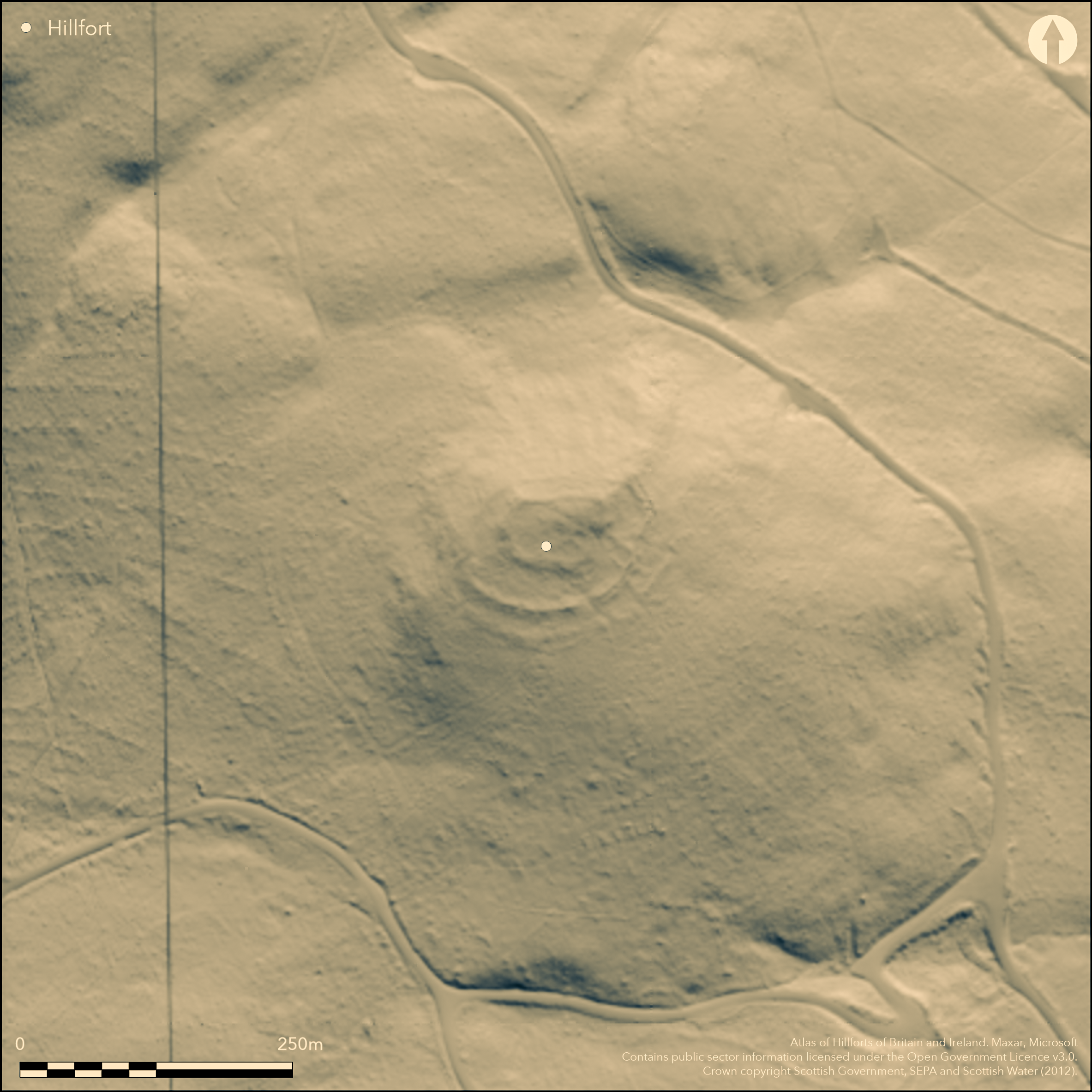
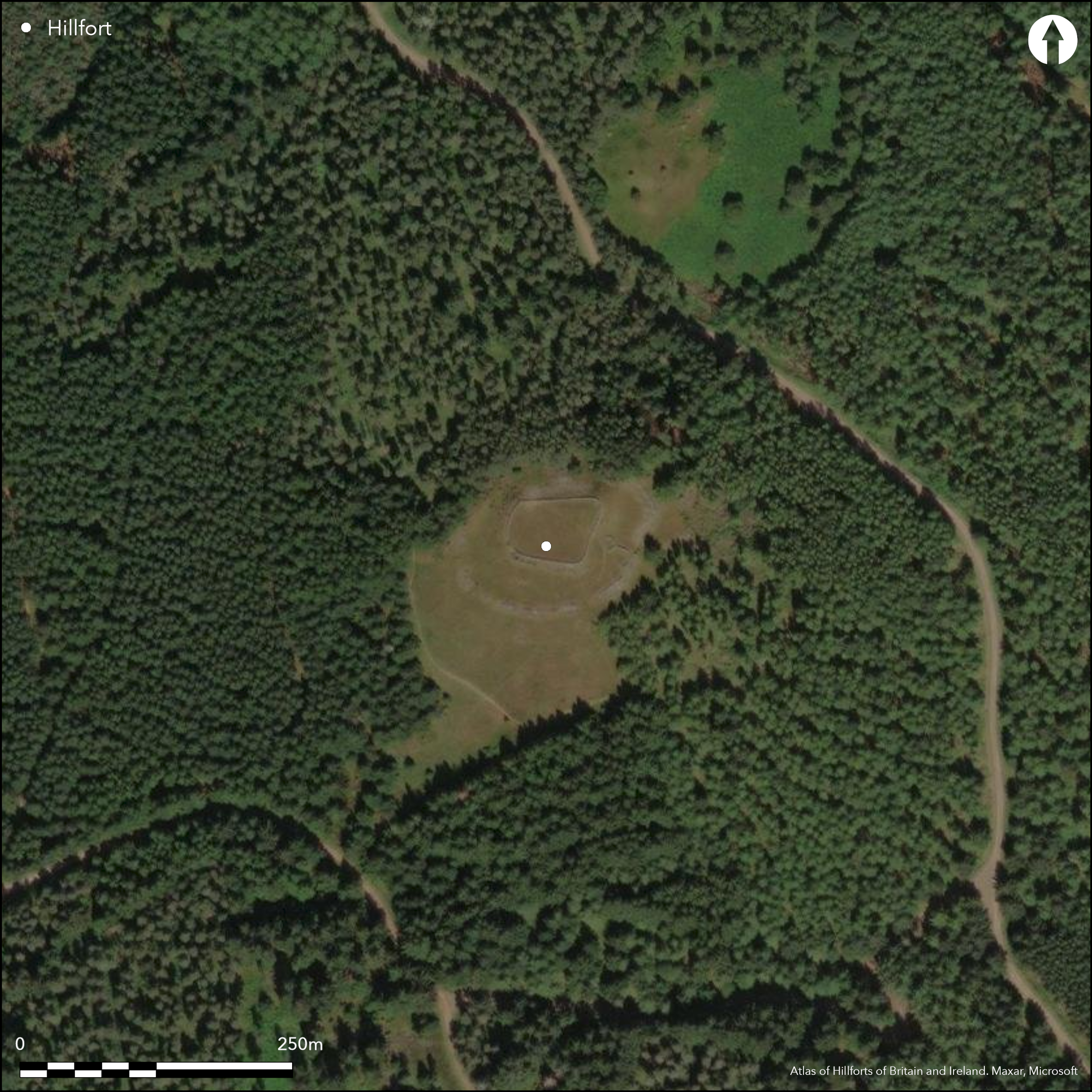
This fort is situated on the Castle Knowe, one of several local summits on the ridge above Cardrona, and now lies in a clearing in an extensive coniferous forest. The defences comprise two widely-spaced stone walls, one forming an inner enclosure on the very summit, and the other an outer enclosure following a shoulder lower down the slope. The inner enclosure is trapezoidal on plan and heavily robbed to build the wall of the sheepfold that probably roughly replicates its shape, so much so that little more than a band of rubble survives along the SSW, and a scree of rubble on the NNE. The featureless interior measures about 49m from E to W by 33m transversely (0.13ha) and there is a probable entrance on the WSW, lining up with one of two entrances through the outer wall. The latter is much better preserved, though along the NNE side it forms a single scree of rubble with the inner wall. Elsewhere around the southern half of the circuit, however, it forms a mound of rubble some 6m in thickness by 1.2m in height, and where the debris has been cleared away the outer face has been revealed over a considerable distance, still standing up to 0.6m high in up to five courses. The interior of this outer enclosure is oval on plan and considerably larger than the inner, measuring up to 100m from E to W by 65m transversely (0.53ha). Its entrances lie on the SSE and WSW, the latter apparently approached obliquely to expose the visitor's right side. There are also traces of what appears as a third line, now reduced to low stony banks, lying a further 10m to 15m beyond the outer wall, but a series of returns suggest that these are later enclosures utilising the earlier defences. While there is no stratigraphy to demonstrate the relationship between the inner and outer enclosures, it is likely that the outer has been a free-standing fortification.
Citizen Science: ✗
Reliability of Data: Confirmed
Reliability of Interpretation: Confirmed
X: -346203 Y: 7483929 (EPSG: 3857)
Longitude: -3.1099985701777695 Latitude: 55.62401661394197 (EPSG:4326)
Country: Scotland
Current County or Unitary Authority: Scottish Borders
Historic County: Peeblesshire
Current Parish/Community/Council/Townland: Traquair
None
| Extant | ✓ |
| Cropmark | ✗ |
| Likely Destroyed | ✗ |
Clearing in a modern coniferous plantation
| Woodland | ✗ |
| Commercial Forestry Plantation | ✓ |
| Parkland | ✗ |
| Pasture (Grazing) | ✗ |
| Arable | ✗ |
| Scrub/Bracken | ✗ |
| Bare Outcrop | ✗ |
| Heather/Moorland | ✓ |
| Heath | ✗ |
| Built-up | ✗ |
| Coastal Grassland | ✗ |
| Other | ✗ |
None
| Contour Fort | ✓ |
| Partial Contour Fort | ✗ |
| Promontory Fort | ✗ |
| Hillslope Fort | ✗ |
| Level Terrain Fort | ✗ |
| Marsh Fort | ✗ |
| Multiple Enclosure Fort | ✓ |
| Hilltop | ✓ |
| Coastal Promontory | ✗ |
| Inland Promontory | ✗ |
| Valley Bottom | ✗ |
| Knoll/Hillock/Outcrop | ✗ |
| Ridge | ✗ |
| Cliff/Plateau-edge/Scarp | ✗ |
| Hillslope | ✗ |
| Lowland | ✗ |
| Spur | ✗ |
Dominant Topographic Feature: None
| North | ✗ |
| Northeast | ✗ |
| East | ✗ |
| Southeast | ✗ |
| South | ✗ |
| Southwest | ✗ |
| West | ✗ |
| Northwest | ✗ |
| Level | ✓ |
Altitude: 328.0m
N/A
In the absence of excavation, there are neither stratified artefacts nor radiocarbon dates to provide a chronology for the defences.
Reliability: D - None
| Pre 1200BC | ✗ |
| 1200BC - 800BC | ✗ |
| 800BC - 400BC | ✗ |
| 400BC - AD50 | ✗ |
| AD50 - AD400 | ✗ |
| AD400 - AD 800 | ✗ |
| Post AD800 | ✗ |
| Unknown | ✓ |
| Pre Hillfort: | None |
| Post Hillfort: | THe inner enclosure is occupied by a stone sheepfold |
Photographed by RCAHMS Aerial Survey Programme in 1983, and 1992. 1970, 2001
| 1st Identified Map Depiction (1856): | Annotated Fort on the 1st edition OS 25-inch map (Peebles 1859, sheet 13.16) |
| Other (1864): | Listed by William Chambers (1864, 29) |
| Earthwork Survey (1886): | Sketch-plan and description by David Christison (1887, 18-21, fig 2) |
| Other (1894): | Visited (Wilson 1894, 23-4) |
| Earthwork Survey (1960): | Plan and description (RCAHMS 1967, 106-7, no.268, fig 83; RCAHMS PBD 94/1-2) |
| Other (1961): | Visited by the OS |
| Other (1970): | Scheduled |
| Other (1974): | Revised at 1:2500 by the OS |
| Earthwork Survey (2013): | By Rubicon Heritage Services (Baker & O'Flaherty 2014) |
Featureless apart from a later stone-walled sheepfold
None
| None | ✓ |
| Spring | ✗ |
| Stream | ✗ |
| Pool | ✗ |
| Flush | ✗ |
| Well | ✗ |
| Other | ✗ |
None
| No Known Features | ✓ |
| Round Stone Structures | ✗ |
| Rectangular Stone Structures | ✗ |
| Curvilinear Platforms | ✗ |
| Other Roundhouse Evidence | ✗ |
| Pits | ✗ |
| Quarry Hollows | ✗ |
| Other | ✗ |
None
| No Known Excavation | ✓ |
| Pits | ✗ |
| Postholes | ✗ |
| Roundhouses | ✗ |
| Rectangular Structures | ✗ |
| Roads/Tracks | ✗ |
| Quarry Hollows | ✗ |
| Other | ✗ |
| Nothing Found | ✗ |
None
| No Known Geophysics | ✓ |
| Pits | ✗ |
| Roundhouses | ✗ |
| Rectangular Structures | ✗ |
| Roads/Tracks | ✗ |
| Quarry Hollows | ✗ |
| Other | ✗ |
| Nothing Found | ✗ |
None
| No Known Finds | ✓ |
| Pottery | ✗ |
| Metal | ✗ |
| Metalworking | ✗ |
| Human Bones | ✗ |
| Animal Bones | ✗ |
| Lithics | ✗ |
| Environmental | ✗ |
| Other | ✗ |
NO APPARENT FEATURES
| APs Not Checked | ✗ |
| None | ✓ |
| Roundhouses | ✗ |
| Rectangular Structures | ✗ |
| Pits | ✗ |
| Postholes | ✗ |
| Roads/Tracks | ✗ |
| Other | ✗ |
See main summary
| 2: | None |
| 2: | None |
Guard Chambers: ✗
Chevaux de Frise: ✗
| 1. Simple Gap (South): | None |
| 2. Oblique (West): | Oblique approach exposing right side |
Inner and outer enclosures, with a series of probably later enclosures butted onto the exterior of the outer
| Area 1: | 0.13ha. |
| Area 2: | 0.53ha. |
| Total: | 0.53ha. |
Total Footprint Area: 0.56ha.
None
| ✗ | None |
| ✓ | None |
| NE Quadrant: | 2 |
| SE Quadrant: | 2 |
| SW Quadrant: | 2 |
| NW Quadrant: | 2 |
| Total: | 2 |
| Partial Univallate | ✗ |
| Univallate | ✗ |
| Partial Bivallate | ✗ |
| Bivallate | ✓ |
| Partial Multivallate | ✗ |
| Multivallate | ✗ |
| Unknown | ✗ |
| Partial Univallate | ✗ |
| Univallate | ✓ |
| Partial Bivallate | ✗ |
| Bivallate | ✗ |
| Partial Multivallate | ✗ |
| Multivallate | ✗ |
None
| None | ✗ |
| Earthen Bank | ✗ |
| Stone Wall | ✓ |
| Rubble | ✗ |
| Wall-walk | ✗ |
| Evidence of Timber | ✗ |
| Vitrification | ✗ |
| Other Burning | ✗ |
| Palisade | ✗ |
| Counter Scarp Bank | ✗ |
| Berm | ✗ |
| Unfinished | ✗ |
| Other | ✗ |
None
| None | ✗ |
| Earthen Bank | ✗ |
| Stone Wall | ✗ |
| Murus Duplex | ✗ |
| Timber-framed | ✗ |
| Timber-laced | ✗ |
| Vitrification | ✗ |
| Other Burning | ✗ |
| Palisade | ✗ |
| Counter Scarp Bank | ✗ |
| Berm | ✗ |
| Unfinished | ✗ |
| No Known Excavation | ✓ |
| Other | ✗ |
| ✗ | None |
| ✗ | None |
Number of Ditches: None
| ✗ | None |
Baker, L & O'Flaherty, E (2014) Archaeological Measured Survey of Castle Knowe Fort, Scottish Borders, Unpublished report. Rubicon Heritage Services
Chambers, W (1864) A History of Peeblesshire. William and Robert Chambers: Edinburgh and London
Christison, D (1887) 'The prehistoric forts of Peeblesshire'. Proc Soc Antiq Scot 21 (1886-7), 13-82
RCAHMS (1967) The Royal Commission on the Ancient and Historical Monuments of Scotland. Peeblesshire: an inventory of the ancient monuments, 2v. HMSO: Edinburgh
Wilson, J et al (1894) Excursions of the Innerleithen Alpine Club, 1889-94, 21-4
Atlas of Hillforts:
Wikidata:
This work is licensed under CC BY-SA 4.0![]()
![]()
![]() and should be cited as:
and should be cited as:
Lock, Gary and Ralston, Ian. 2024. Atlas of Hillforts of Britain and Ireland. Available at: https://hillforts.arch.ox.ac.uk
Document Version 1.1