
LiDAR 1m DTM Hillshade
Satellite Imagery
LiDAR 1m DTM Hillshade
Satellite Imagery
Scroll left/right to view further images.
HER: Midlothian per East Lothian Council MEL7999 (None)
NMR: NT 15 NE 14 (50152)
SM: 1163
NGR: NT 1928 5963
X: 319280 Y: 659630 (OSGB36)
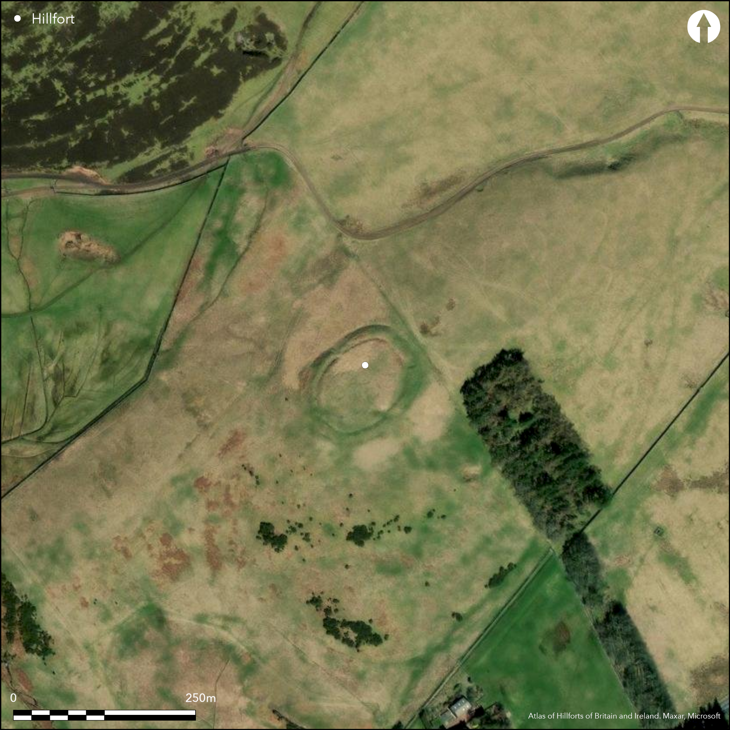
This fort or fortified settlement is situated on the rounded summit of Camp Hill and has been surveyed and excavated on numerous occasions. Oval on plan, the visible defences comprise both earthworks and a palisade trench, but whether these were constructed sequentially or were conceived as elements in a single scheme is uncertain. The earthwork component comprises twin ditches with a medial rampart and an outer counterscarp bank, though in places the latter and the outer ditch have been reduced to little more than a terrace. There is no trace of an inner rampart, but lying between 4m and 6m behind the ditch there is a palisade trench, intermittently visible where it cuts through or is obliterated by some of the timber round-houses packed within the interior. The earthwork has entrances on the SE, SW and NW, but while that on the SW also served the palisaded enclosure in the interior, it is unclear whether there were corresponding gaps in the palisade at the other two. The palisade encloses an area measuring about 59m from NE to SW by 40m transversely (0.2ha), whereas the corresponding measurements for the areas enclosed by the inner ditch are 70m and 54m respectively (0.33ha). Traces of no fewer than twenty-five ring-ditch houses are visible sprawled across the area enclosed by the inner ditch, displaying a range of relationships in which they not only intersect their immediate neighbours, but also appear to cut or be cut by the palisade trench and the inner ditch. While this last relationship may have been caused by erosion along the inner lip of the ditch, the various elements of the perimeter and the houses they enclose evidently represent a complex sequence. Excavations carried out by Robert Stevenson and Kenneth Steer in 1940 and Stevenson again in 1947-8 (Stevenson 1949), the Edinburgh University Archaeological Society in 1951-3, and by George Watson's Archaeological Society in 1968 (Brown 1968), however, have done little to clarify either the sequence of enclosure or its date. While Stevenson concentrated on two of the ring-ditch houses, the other excavations focused on the SW entrance and the character of the defences. The medial rampart was found to be little more than a dump, which Stuart Piggott, writing up the excavations of the Edinburgh University work initially believed had been faced with timberwork set in a foundation trench, and linked to palisade trenches that formed a passage running up between the terminals of the rampart and the inner ditch at the SW entrance. The subsequent brief report of the section dug in 1968, however, for which Piggott's authority is also inferred, noted that the foundation trench lay beneath the rampart, but claimed that a 'low wall of packing stones' had been piled up against the outside of the timberwork before it was encased in the rampart; the conclusion was offered that the earthwork had adapted a free-standing palisade (Brown 1968). Apart from a gold torc said to have been found by a labourer trenching within the interior in the late 18th century (Wilson 1851, 318), finds from Stevenson's excavations include a fragment of a glass bangle, coarse pottery, stone balls and a perforated stone.
Citizen Science: ✗
Reliability of Data: Confirmed
Reliability of Interpretation: Confirmed
X: -366238 Y: 7523297 (EPSG: 3857)
Longitude: -3.2899710193619627 Latitude: 55.82318529388743 (EPSG:4326)
Country: Scotland
Current County or Unitary Authority: Midlothian
Historic County: Midlothian
Current Parish/Community/Council/Townland: Penicuik
None
| Extant | ✓ |
| Cropmark | ✗ |
| Likely Destroyed | ✗ |
Previously had bracken on it but this has been sprayed
| Woodland | ✗ |
| Commercial Forestry Plantation | ✗ |
| Parkland | ✗ |
| Pasture (Grazing) | ✓ |
| Arable | ✗ |
| Scrub/Bracken | ✗ |
| Bare Outcrop | ✗ |
| Heather/Moorland | ✓ |
| Heath | ✗ |
| Built-up | ✗ |
| Coastal Grassland | ✗ |
| Other | ✗ |
None
| Contour Fort | ✓ |
| Partial Contour Fort | ✗ |
| Promontory Fort | ✗ |
| Hillslope Fort | ✗ |
| Level Terrain Fort | ✗ |
| Marsh Fort | ✗ |
| Multiple Enclosure Fort | ✗ |
| Hilltop | ✓ |
| Coastal Promontory | ✗ |
| Inland Promontory | ✗ |
| Valley Bottom | ✗ |
| Knoll/Hillock/Outcrop | ✗ |
| Ridge | ✗ |
| Cliff/Plateau-edge/Scarp | ✗ |
| Hillslope | ✗ |
| Lowland | ✗ |
| Spur | ✗ |
Dominant Topographic Feature: None
| North | ✗ |
| Northeast | ✗ |
| East | ✗ |
| Southeast | ✗ |
| South | ✗ |
| Southwest | ✗ |
| West | ✗ |
| Northwest | ✗ |
| Level | ✓ |
Altitude: 329.0m
N/A
A fragment of glass bangle probably dating from the early centuries AD is unstratified. The context of the gold torc from the fort illustrated by Wilson (1851, 318); said to come from trenching the interior, the preservation of the ring-ditch houses contradicts this statement, the only sign of disturbance being what appears to be an excavation trench immediately NE of the SE entrance.
Reliability: D - None
| Pre 1200BC | ✗ |
| 1200BC - 800BC | ✗ |
| 800BC - 400BC | ✗ |
| 400BC - AD50 | ✗ |
| AD50 - AD400 | ✗ |
| AD400 - AD 800 | ✗ |
| Post AD800 | ✗ |
| Unknown | ✓ |
| Pre Hillfort: | None |
| Post Hillfort: | None |
Photographed by RCAHMS Aerial Survey Programme under a range of conditions in 1980, 1981, 1982, 1985, 1986, 2001, 2005, 2007, 2010 and 2015, and by drone for photoscan plan under contract to create a topographical model.
| Excavation (1790): | 'Trenching' uncovered a gold torc (Wilson 1851, 318) |
| 1st Identified Map Depiction (1852): | Annotated Fort on the 1st edition OS 6-inch map (Edinburghshire 1853, sheets 11 & 17) |
| Earthwork Survey (1913): | Plan and description (RCAHMS 1929, 156-7, no.206, fig 194; RCAHMS MLD 10/1) |
| Other (1935): | Scheduled |
| Excavation (1940): | By Robert Stevenson and Kenneth Steer (Stevenson 1949) |
| Excavation (1947): | By Robert Stevenson (1949) |
| Excavation (1948): | By Robert Stevenson (1948; 1949; Archive in RCAHMS MLD 10/2 P/CO, MS28/320, MS 7310/1) |
| Earthwork Survey (1948): | Based on RCAHMS plan (Stevenson 1949, 1, fig 1) |
| Excavation (1951): | Edinburgh University Archaeological Society under the general direction of Stuart Piggott (1958, 61-6) |
| Excavation (1952): | Edinburgh University Archaeological Society under the general direction of Stuart Piggott (1958, 61-6) |
| Excavation (1953): | Edinburgh University Archaeological Society under the general direction of Stuart Piggott (1958, 61-6; C M Piggott 1953) |
| Earthwork Survey (1953): | Based on RCAHMS plan (Piggott 1958, 62, fig 1) |
| Excavation (1968): | George Watson's Archaeological Society under the general direction of Stuart Piggott (Brown 1968) |
| Other (1970): | Resurveyed at 1:2500 by the OS |
| Earthwork Survey (1980): | Unfinished training survey by Edinburgh University night class |
| Earthwork Survey (1993): | Plan by Angela Gannon and S Halliday (RCAHMS DC43376) |
| Other (1995): | Re-Scheduled |
| LiDAR Survey (2015): | Digital model created by RCAHMS from drone photography, and ground scanning data also collected |
At least twenty-five ring-ditch houses, two of which have been excavated (Stevenson 1949)._
None
| None | ✓ |
| Spring | ✗ |
| Stream | ✗ |
| Pool | ✗ |
| Flush | ✗ |
| Well | ✗ |
| Other | ✗ |
At least twenty-five ring-ditch houses. An internal quarry ditch is present.
| No Known Features | ✗ |
| Round Stone Structures | ✗ |
| Rectangular Stone Structures | ✗ |
| Curvilinear Platforms | ✗ |
| Other Roundhouse Evidence | ✓ |
| Pits | ✗ |
| Quarry Hollows | ✓ |
| Other | ✗ |
Two ring-ditch houses excavated
| No Known Excavation | ✗ |
| Pits | ✓ |
| Postholes | ✓ |
| Roundhouses | ✓ |
| Rectangular Structures | ✗ |
| Roads/Tracks | ✗ |
| Quarry Hollows | ✗ |
| Other | ✗ |
| Nothing Found | ✗ |
None
| No Known Geophysics | ✓ |
| Pits | ✗ |
| Roundhouses | ✗ |
| Rectangular Structures | ✗ |
| Roads/Tracks | ✗ |
| Quarry Hollows | ✗ |
| Other | ✗ |
| Nothing Found | ✗ |
Apart from a gold torc said to have been found by a labourer trenching within the interior in the late 18th century (Wilson 1851, 318), finds from Stevenson's excavations include a fragment of a glass bangle, coarse pottery, stone balls and a perforated stone (1949).he also refers to a fragment of a quern in a pit, and an anvil stone in the packing of the palisade trench, while the trench dug in 1968 found two hammerstones in the body of the rampart (Brown 1968).
| No Known Finds | ✗ |
| Pottery | ✓ |
| Metal | ✓ |
| Metalworking | ✗ |
| Human Bones | ✗ |
| Animal Bones | ✗ |
| Lithics | ✗ |
| Environmental | ✗ |
| Other | ✓ |
None
| APs Not Checked | ✗ |
| None | ✗ |
| Roundhouses | ✓ |
| Rectangular Structures | ✗ |
| Pits | ✗ |
| Postholes | ✗ |
| Roads/Tracks | ✗ |
| Other | ✗ |
See main summary
| 3: | None |
| 2: | None |
Guard Chambers: ✗
Chevaux de Frise: ✗
| 1. Simple Gap (South east): | None |
| 2. Passage-way/Corridor (South west): | Excavation revealed a timber lined passageway |
| 3. Simple Gap (North west): | None |
Twin ditches with a medial rampart and counterscarp bank, with a palisade trench within the interior
| Area 1: | 0.33ha. |
| Total: | 0.33ha. |
Total Footprint Area: 0.66ha.
None
| ✓ | None |
| ✓ | Omits the palisade trench as an integrated line of defence |
| NE Quadrant: | 1 |
| SE Quadrant: | 1 |
| SW Quadrant: | 1 |
| NW Quadrant: | 1 |
| Total: | 1 |
| Partial Univallate | ✗ |
| Univallate | ✓ |
| Partial Bivallate | ✗ |
| Bivallate | ✗ |
| Partial Multivallate | ✗ |
| Multivallate | ✗ |
| Unknown | ✗ |
| Partial Univallate | ✗ |
| Univallate | ✗ |
| Partial Bivallate | ✗ |
| Bivallate | ✗ |
| Partial Multivallate | ✗ |
| Multivallate | ✗ |
None
| None | ✗ |
| Earthen Bank | ✓ |
| Stone Wall | ✗ |
| Rubble | ✗ |
| Wall-walk | ✗ |
| Evidence of Timber | ✗ |
| Vitrification | ✗ |
| Other Burning | ✗ |
| Palisade | ✓ |
| Counter Scarp Bank | ✓ |
| Berm | ✗ |
| Unfinished | ✗ |
| Other | ✗ |
While Piggott considered that the outer ditch on the NW was unfinished, the evidence is not particularly convincing.
| None | ✗ |
| Earthen Bank | ✓ |
| Stone Wall | ✗ |
| Murus Duplex | ✗ |
| Timber-framed | ✗ |
| Timber-laced | ✗ |
| Vitrification | ✗ |
| Other Burning | ✗ |
| Palisade | ✓ |
| Counter Scarp Bank | ✓ |
| Berm | ✗ |
| Unfinished | ✗ |
| No Known Excavation | ✗ |
| Other | ✗ |
| ✗ | None |
| ✓ | None |
Number of Ditches: 2
| ✗ | None |
Brown, I (1968) 'Silverburn, Braidwood, Iron Age fort'. Disc Exc Scot (1968), 26
Feachem, R (1963) A guide to prehistoric Scotland. Batsford: London (pp 135-6)
Piggott, C M (1953) 'Braidwood Fort'. Disc Exc Scot (1953), 13
Piggott, S (1958) 'Excavations at Braidwood Fort, Midlothian and Craig's Quarry, Dirleton, East Lothian'. Proc Soc Antiq Scot 91 (1957-8), 61-77
RCAHMS (1929) The Royal Commission on the Ancient and Historical Monuments and Constructions of Scotland. Tenth report with Inventory of Monuments and Constructions in the Counties of Midlothian and West Lothian. HMSO: Edinburgh
Stevenson, R B K (1949) 'Braidwood Fort, Midlothian: the exploration of two huts'. Proc Soc Antiq Scot 83 (1948-9), 1-11
Stevenson, R B K (1948) 'Braidwood and Rullion Green, Midlothian'. Disc Exc Scot (1948), 8-9
Wilson, D (1851) The archaeology and prehistoric annals of Scotland. Sutherland and Knox: Edinburgh
Atlas of Hillforts:
Wikidata:
This work is licensed under CC BY-SA 4.0![]()
![]()
![]() and should be cited as:
and should be cited as:
Lock, Gary and Ralston, Ian. 2024. Atlas of Hillforts of Britain and Ireland. Available at: https://hillforts.arch.ox.ac.uk
Document Version 1.1