LiDAR 1m DTM Hillshade
Satellite Imagery
LiDAR 1m DTM Hillshade
Satellite Imagery
Scroll left/right to view further images.
HER: City of Edinburgh No record found (None)
NMR: NT 16 NW 1 (50318)
SM: 1213
NGR: NT 1355 6693
X: 313550 Y: 666930 (OSGB36)
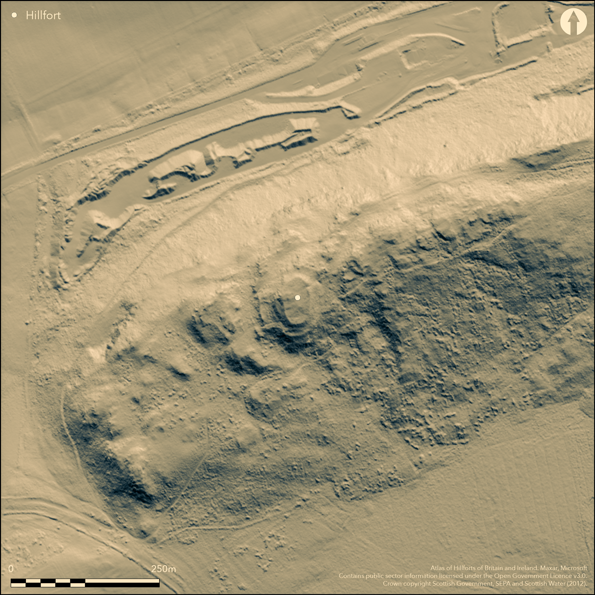
The small fort on the rocky summit of Dalmahoy Hill lies at the core of a series of outer enclosures, the walls of which follow natural terraces between outcrops and block off access up and down the gullies on the SE and SW flanks of the hill. The fort crowning the summit is oval on plan and measures about 43m from N to S by 25m transversely (0.08ha) within a heavily robbed robbed wall some 3.6m in thickness. Where runs of outer face survive on the E and S, this wall has measured at least 3m in height and there is an entrance on the NE, opening externally onto a terrace with traces of walling around its lip and an outer entrance. While the RCAHMS investigators who first drew up a plan of the fort in 1926, recognised this outer entrance and traces of walling between the outcrops around the W flank, it was not until 1948 that the full extent of the outer enclosures taking in the whole hilltop was recognised, including a major enclosure extending for about 200m along the ridge to the ENE, and a series of lesser walls combining with the outcrops to enclose the terraces stepping down from the fort on the W. The overall area enclosed measured some 360m in length from ENE to WSW and extends to about 2ha. The plan was traced out by Robert Stevenson and led him to identify the summit fortification as a citadel within an arrangement of contemporary outer enclosures, thus giving rise to the concept of a 'nuclear fort', a type that has become synonymous with early medieval fortifications. While the wall extending along the SE flank of the ridge-top is between 2.4m and 3m thick, the walls on the W appear of slighter construction, and Stevenson himself conceded that some of the lesser banks forming enclosures at the foot of the SW flank were possibly agricultural, but Feachem (1955, 78-9, fig 6; 1963, 137-8) at first accepted the broad outline of the hypothesis, albeit that he he subsequently considered the visible remains of the small summit fort to be a later insertion into what was probably an earlier Iron Age fort. This latter hypothesis seems inherently more likely today, but the full extent of this earlier fort is much less certain. It presumably took in the summit of the hill and the ridge to the ENE, and had one entrance in its SSE side opening into the gully on the E side of the summit, with perhaps a second at the N end of the gully, though the course of the perimeter on the NW side of the ridge is far from clear. Another entrance route seems to have mounted the W flank of the hill via a second gully, passing through at least two of the enclosure walls on this side, but without any obvious route to the entrance of the summit fort. Unlike the Dunion (Atlas No.3368), the obvious parallel for a large prehistoric fort formed of multiple enclosures, there are no traces of round-houses within any of the enclosures and the structure noted on the summit of the ridge by Stevenson is perhaps more likely to be the remains of a robbed cairn.
Citizen Science: ✗
Reliability of Data: Confirmed
Reliability of Interpretation: Confirmed
X: -376675 Y: 7536105 (EPSG: 3857)
Longitude: -3.3837299363819935 Latitude: 55.887764391829556 (EPSG:4326)
Country: Scotland
Current County or Unitary Authority: City of Edinburgh
Historic County: Midlothian
Current Parish/Community/Council/Townland: Ratho
None
| Extant | ✓ |
| Cropmark | ✗ |
| Likely Destroyed | ✗ |
None
| Woodland | ✗ |
| Commercial Forestry Plantation | ✗ |
| Parkland | ✗ |
| Pasture (Grazing) | ✓ |
| Arable | ✗ |
| Scrub/Bracken | ✓ |
| Bare Outcrop | ✗ |
| Heather/Moorland | ✓ |
| Heath | ✗ |
| Built-up | ✗ |
| Coastal Grassland | ✗ |
| Other | ✗ |
None
| Contour Fort | ✓ |
| Partial Contour Fort | ✗ |
| Promontory Fort | ✗ |
| Hillslope Fort | ✗ |
| Level Terrain Fort | ✗ |
| Marsh Fort | ✗ |
| Multiple Enclosure Fort | ✓ |
| Hilltop | ✓ |
| Coastal Promontory | ✗ |
| Inland Promontory | ✗ |
| Valley Bottom | ✗ |
| Knoll/Hillock/Outcrop | ✗ |
| Ridge | ✗ |
| Cliff/Plateau-edge/Scarp | ✗ |
| Hillslope | ✗ |
| Lowland | ✗ |
| Spur | ✗ |
Dominant Topographic Feature: None
| North | ✗ |
| Northeast | ✗ |
| East | ✗ |
| Southeast | ✗ |
| South | ✗ |
| Southwest | ✗ |
| West | ✗ |
| Northwest | ✗ |
| Level | ✓ |
Altitude: 246.0m
N/A
Dalmahoy was used by Robert Stevenson as a case study in his exposition of the character of early medieval fortifications, the appearance of a series of enclosures around a citadel leading him to coin the term 'nuclear fort'; the view taken here is more sceptical in either identifying all the outlying enclosures as fortifications or that the represent a coherent and contemporary scheme. Nevertheless, Feachem notes that a gold stud cap and several fragments of moulds of early medieval date were picked up in one of the surrounding enclosures (Feachem 1963, 136-7), but in the absence of excavation, there are neither stratified artefacts nor radiocarbon dates to provide a chronology for the defences.
Reliability: D - None
| Pre 1200BC | ✗ |
| 1200BC - 800BC | ✗ |
| 800BC - 400BC | ✗ |
| 400BC - AD50 | ✗ |
| AD50 - AD400 | ✗ |
| AD400 - AD 800 | ✗ |
| Post AD800 | ✗ |
| Unknown | ✓ |
| Pre Hillfort: | Five cupmarks have been noted on a stone on the summit (Naddair 1989) |
| Post Hillfort: | None |
| Artefactual: | Stray finds of a gold stud cap and several fragments of moulds of early medieval date are reported by Feachem (1963, 136-7) |
| Morphology/Earthwork/Typology: | Supposed 'nuclear fort' |
Photographed by John Dewar (held by RCAHMS) in 1967 and 1971, and RCAHMS Aerial Survey Programme in 1976, 1998 and 2005 The relatively low Scheduled Monument Number suggests that Dalmahoy was first Scheduled round about the same time as neighbouring Kaimes in 1924, but according to the summary appearing on the Historic Environment Scotland Decision Portal it was not added to the Schedule until 1998
| 1st Identified Written Reference (1893): | Noted by Frederick Coles and James Cunningham (Coles 1896, 273) |
| Earthwork Survey (1927): | Plan and description (RCAHMS 1929, 162-3, no.217, fig 200; RCAHMS MLD 29/1-2) |
| Earthwork Survey (1949): | Plan and description by Robert Stevenson (1949, 187-91, fig 1) |
| Earthwork Survey (1955): | Redrawn from Stevenson by Richard Feachem, who subsequently mentions that an early medieval gold stud cap and several fragments of moulds were picked up in one of the surrounding enclosures (Feachem 1955; 1963, 136-7) |
| 1st Identified Map Depiction (1958): | OS 6-inch map |
| Other (1965): | Resurveyed at 1:2500 by the OS |
| Other (1998): | Scheduled |
| Other (2008): | Re-Scheduled |
Featureless
None
| None | ✓ |
| Spring | ✗ |
| Stream | ✗ |
| Pool | ✗ |
| Flush | ✗ |
| Well | ✗ |
| Other | ✗ |
None
| No Known Features | ✓ |
| Round Stone Structures | ✗ |
| Rectangular Stone Structures | ✗ |
| Curvilinear Platforms | ✗ |
| Other Roundhouse Evidence | ✗ |
| Pits | ✗ |
| Quarry Hollows | ✗ |
| Other | ✗ |
None
| No Known Excavation | ✓ |
| Pits | ✗ |
| Postholes | ✗ |
| Roundhouses | ✗ |
| Rectangular Structures | ✗ |
| Roads/Tracks | ✗ |
| Quarry Hollows | ✗ |
| Other | ✗ |
| Nothing Found | ✗ |
None
| No Known Geophysics | ✓ |
| Pits | ✗ |
| Roundhouses | ✗ |
| Rectangular Structures | ✗ |
| Roads/Tracks | ✗ |
| Quarry Hollows | ✗ |
| Other | ✗ |
| Nothing Found | ✗ |
None
| No Known Finds | ✓ |
| Pottery | ✗ |
| Metal | ✗ |
| Metalworking | ✗ |
| Human Bones | ✗ |
| Animal Bones | ✗ |
| Lithics | ✗ |
| Environmental | ✗ |
| Other | ✗ |
NO APPARENT FEATURES
| APs Not Checked | ✗ |
| None | ✓ |
| Roundhouses | ✗ |
| Rectangular Structures | ✗ |
| Pits | ✗ |
| Postholes | ✗ |
| Roads/Tracks | ✗ |
| Other | ✗ |
See main summary
| 4: | There are numerous gaps in the perimeter caused partly by the character of the topography |
| 2: | Single entrance in the summit fort, but with others in the outlying enclosures |
Guard Chambers: ✗
Chevaux de Frise: ✗
| 1. Simple Gap (North east): | In the summit fort and with a gap in an outer wall immediately below it |
| 2. Over-lapping (South east): | In the large ridge enclosure to the ENE of the summit fort, opening into a gully and with the E wall terminal apparently turning inwards to expose the visitor's right side. |
| 3. Simple Gap (North west): | Into the opposite end of the gully of entrance 2 |
| 4. Oblique (South west): | via a gully on the SW, the character of the topography creating an inturned terminal on one side that exposes the visitor's right side |
A small inner fort with a substantial wall, and lesser walls intermittently visible forming a series of outer enclosures
| Area 1: | 0.08ha. |
| Area 2: | 2.0ha. |
| Total: | 2.0ha. |
Total Footprint Area: Noneha.
None
| ✗ | None |
| ✓ | This model does not fit the intermittent character of the outer defences particularly well so they have been omitted in favour of the inner fort on the summit |
| NE Quadrant: | 1 |
| SE Quadrant: | 1 |
| SW Quadrant: | 1 |
| NW Quadrant: | 1 |
| Total: | 1 |
| Partial Univallate | ✗ |
| Univallate | ✓ |
| Partial Bivallate | ✗ |
| Bivallate | ✗ |
| Partial Multivallate | ✗ |
| Multivallate | ✗ |
| Unknown | ✗ |
| Partial Univallate | ✗ |
| Univallate | ✗ |
| Partial Bivallate | ✗ |
| Bivallate | ✗ |
| Partial Multivallate | ✗ |
| Multivallate | ✗ |
None
| None | ✗ |
| Earthen Bank | ✗ |
| Stone Wall | ✓ |
| Rubble | ✗ |
| Wall-walk | ✗ |
| Evidence of Timber | ✗ |
| Vitrification | ✗ |
| Other Burning | ✗ |
| Palisade | ✗ |
| Counter Scarp Bank | ✗ |
| Berm | ✗ |
| Unfinished | ✗ |
| Other | ✗ |
None
| None | ✗ |
| Earthen Bank | ✗ |
| Stone Wall | ✗ |
| Murus Duplex | ✗ |
| Timber-framed | ✗ |
| Timber-laced | ✗ |
| Vitrification | ✗ |
| Other Burning | ✗ |
| Palisade | ✗ |
| Counter Scarp Bank | ✗ |
| Berm | ✗ |
| Unfinished | ✗ |
| No Known Excavation | ✓ |
| Other | ✗ |
| ✗ | None |
| ✗ | None |
Number of Ditches: None
| ✓ | If the outer enclosures are truly elements of the fort, they might be considered as annexes |
Coles, F R (1896) 'Notes on the fortified site on Kaimes Hill'. Proc Soc Antiq Scot 30 (1895-6), 269-74
Feachem, R (1963) A guide to prehistoric Scotland. Batsford: London (pp 135-6)
Naddair, K (1989) 'Dalmahoy hillfort (Ratho parish), cup mark site'. Disc Exc Scot (1989), 51
RCAHMS (1929) The Royal Commission on the Ancient and Historical Monuments and Constructions of Scotland. Tenth report with Inventory of Monuments and Constructions in the Counties of Midlothian and West Lothian. HMSO: Edinburgh
Stevenson, R B K (1949) 'The nuclear fort of Dalmahoy, Midlothian, and other Dark Age capitals'. Proc Soc Antiq Scot 83 (1948-9), 186-98
Atlas of Hillforts:
Wikidata:
This work is licensed under CC BY-SA 4.0![]()
![]()
![]() and should be cited as:
and should be cited as:
Lock, Gary and Ralston, Ian. 2024. Atlas of Hillforts of Britain and Ireland. Available at: https://hillforts.arch.ox.ac.uk
Document Version 1.1