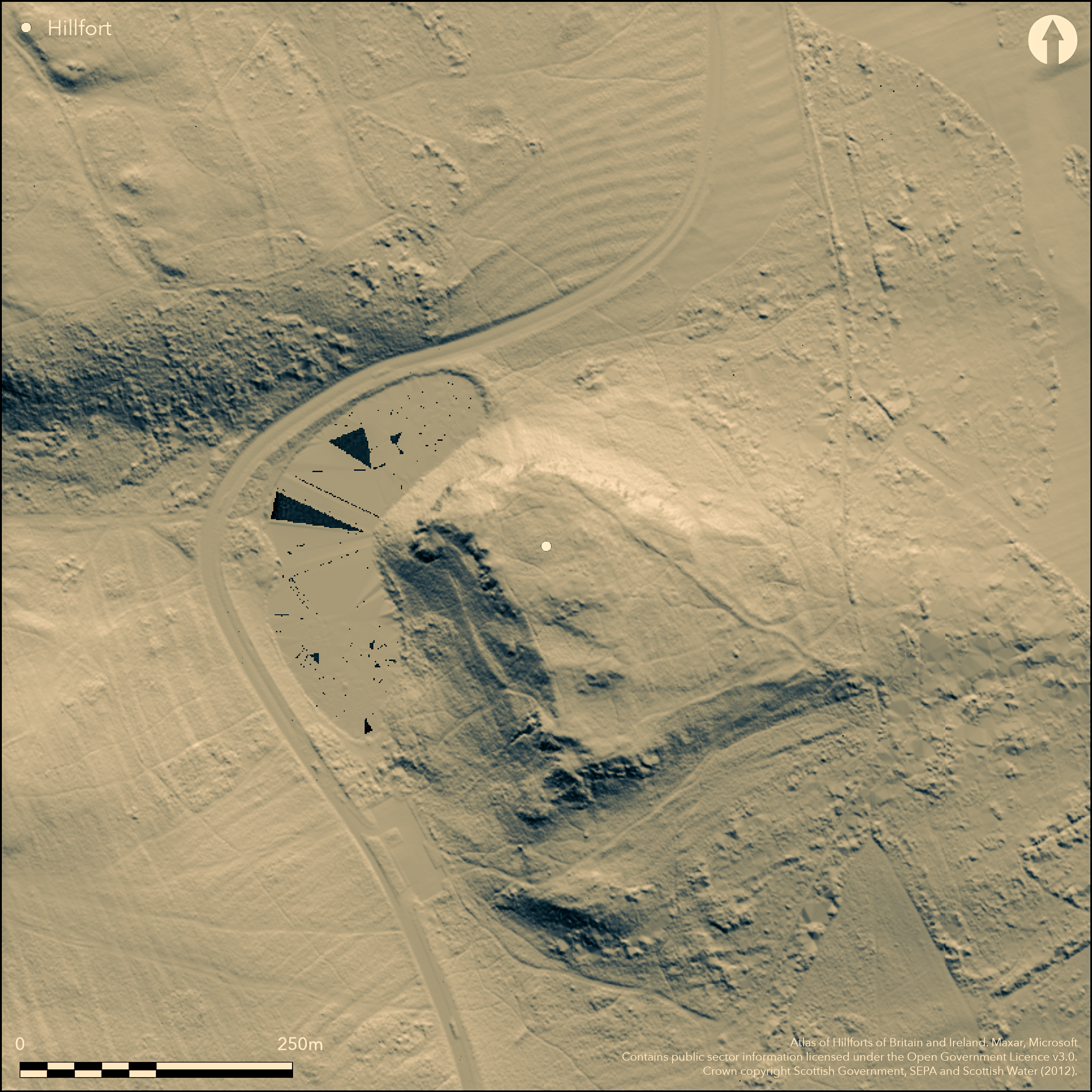
LiDAR 1m DTM Hillshade

Satellite Imagery
LiDAR 1m DTM Hillshade
Satellite Imagery
Scroll left/right to view further images.
HER: City of Edinburgh No record found (None)
NMR: NT 27 SE 49 (52510)
SM: 13032
NGR: NT 2817 7316
X: 328172 Y: 673166 (OSGB36)
This fort is situated on the broad summit of Dunsapie overlooking Dunsapie Loch, a location girt with cliffs and rocky escarpments around three sides and easily accessible only from the sloping E flank. Irregular on plan, the fort appears to have been roughly tailored to the margins of the summit area, measuring internally about 135m in length and contracting from about 65m transversely at the N end to 35m at the S end, but the rampart itself has been very heavily robbed and is difficult to follow. At one point on the NW a row of four stones that may belong to the inner face can be seen, but elsewhere no more than wall core is visible, on the W forming a low scarp and petering out at the S end to reappear and on the E as a bank 4m thick by 1m high; a marked re-entrant in its E side, however, suggests that the perimeter may not be all of a piece, and has perhaps been extended southwards from an original enclosure on the northern and higher end. If so the interior on the S, which gives the impression that it is divided into two courts, is perhaps the remains of a late Iron Age settlement overlying the fort, rather than the fort itself. The only evidence of an entrance is on the NE into the upper end of the fort and is obscured by a later field-bank which mounts the slope obliquely to terminate on the edge of the cliff on the N. Traces of an outer rampart can be seen on the W, while on the E there has possibly been an annexe, though the greater part of it is defined by natural features and the lower end is probably partly, if not wholly, formed as a lynchet on the slope. An oval late Iron Age settlement enclosure is scooped into the slope at the lower end of this supposed annexe, and though the relationship between them is unclear its entrance opens through a break in this lynchet. Any connection between the features interpreted as the annexe and the fort is tenuous at best, and they are probably better considered in the context of a succession of land-use systems exploiting this slope rather than as a subsidiary enclosure of the fort. Finds from the area of the fort include a stone mould and a hoard of three Early Bronze Age flat axes.
Citizen Science: ✗
Reliability of Data: Confirmed
Reliability of Interpretation: Confirmed
X: -350842 Y: 7547711 (EPSG: 3857)
Longitude: -3.1516708592526075 Latitude: 55.946188394818876 (EPSG:4326)
Country: Scotland
Current County or Unitary Authority: City of Edinburgh
Historic County: Midlothian
Current Parish/Community/Council/Townland: Edinburgh
None
| Extant | ✓ |
| Cropmark | ✗ |
| Likely Destroyed | ✗ |
None
| Woodland | ✗ |
| Commercial Forestry Plantation | ✗ |
| Parkland | ✓ |
| Pasture (Grazing) | ✗ |
| Arable | ✗ |
| Scrub/Bracken | ✗ |
| Bare Outcrop | ✗ |
| Heather/Moorland | ✓ |
| Heath | ✗ |
| Built-up | ✗ |
| Coastal Grassland | ✗ |
| Other | ✗ |
None
| Contour Fort | ✓ |
| Partial Contour Fort | ✗ |
| Promontory Fort | ✗ |
| Hillslope Fort | ✗ |
| Level Terrain Fort | ✗ |
| Marsh Fort | ✗ |
| Multiple Enclosure Fort | ✗ |
| Hilltop | ✓ |
| Coastal Promontory | ✗ |
| Inland Promontory | ✗ |
| Valley Bottom | ✗ |
| Knoll/Hillock/Outcrop | ✗ |
| Ridge | ✗ |
| Cliff/Plateau-edge/Scarp | ✗ |
| Hillslope | ✗ |
| Lowland | ✗ |
| Spur | ✗ |
Dominant Topographic Feature: None
| North | ✗ |
| Northeast | ✗ |
| East | ✗ |
| Southeast | ✗ |
| South | ✗ |
| Southwest | ✗ |
| West | ✗ |
| Northwest | ✗ |
| Level | ✓ |
Altitude: 142.0m
N/A
There are neither stratified artefacts nor radiocarbon dates to provide a chronology for the defences.
Reliability: D - None
| Pre 1200BC | ✗ |
| 1200BC - 800BC | ✗ |
| 800BC - 400BC | ✗ |
| 400BC - AD50 | ✗ |
| AD50 - AD400 | ✗ |
| AD400 - AD 800 | ✗ |
| Post AD800 | ✗ |
| Unknown | ✓ |
| Pre Hillfort: | A hoard of three Early Bronze Age flat axes |
| Post Hillfort: | Heavily robbed and overlain by a later field-bank |
None
| 1st Identified Written Reference (1922): | Description (RCAHMS 1929, 9-10, no.10); the stone mould was also discovered in this year |
| Other (1947): | Description by Robert Stevenson (1947, 168, pl xviii) |
| Earthwork Survey (1961): | Sketch-plan of the fort and adjacent settlement by Richard Feachem (Feachem 1963, 135; RCAHMS DC31532 & DP154950) |
| 1st Identified Map Depiction (1966): | OS 6-inch map |
| Other (1975): | Surveyed at 1:2500 by the OS |
| Other (1976): | Visited by the Hill-fort Study Group |
| Excavation (1996): | Small trench excavated by National Museum staff to establish the context of an Early Bronze Age hoard of three flat axes found by a metal detectorist |
| Other (1998): | Description and mapping survey by RCAHMS (1999) |
The interior gives the impression that the southern end is divided into two courts
None
| None | ✓ |
| Spring | ✗ |
| Stream | ✗ |
| Pool | ✗ |
| Flush | ✗ |
| Well | ✗ |
| Other | ✗ |
None
| No Known Features | ✓ |
| Round Stone Structures | ✗ |
| Rectangular Stone Structures | ✗ |
| Curvilinear Platforms | ✗ |
| Other Roundhouse Evidence | ✗ |
| Pits | ✗ |
| Quarry Hollows | ✗ |
| Other | ✗ |
None
| No Known Excavation | ✓ |
| Pits | ✗ |
| Postholes | ✗ |
| Roundhouses | ✗ |
| Rectangular Structures | ✗ |
| Roads/Tracks | ✗ |
| Quarry Hollows | ✗ |
| Other | ✗ |
| Nothing Found | ✗ |
None
| No Known Geophysics | ✓ |
| Pits | ✗ |
| Roundhouses | ✗ |
| Rectangular Structures | ✗ |
| Roads/Tracks | ✗ |
| Quarry Hollows | ✗ |
| Other | ✗ |
| Nothing Found | ✗ |
A reddish sandstone mould was given to the NMAS in 1922. It has matrices for a ring, a horseshoe-shaped object, a dumbbell and a single bar or ingot (NMAS C.M.28; Canmore 52511) A hoard of three Early Bronze Age flat axes was found in 1996 by a metal detectorist (Canmore 110564)
| No Known Finds | ✗ |
| Pottery | ✗ |
| Metal | ✓ |
| Metalworking | ✓ |
| Human Bones | ✗ |
| Animal Bones | ✗ |
| Lithics | ✗ |
| Environmental | ✗ |
| Other | ✗ |
NO APPARENT FEATURES
| APs Not Checked | ✗ |
| None | ✓ |
| Roundhouses | ✗ |
| Rectangular Structures | ✗ |
| Pits | ✗ |
| Postholes | ✗ |
| Roads/Tracks | ✗ |
| Other | ✗ |
See main summary
| 1: | None |
| 2: | None |
Guard Chambers: ✗
Chevaux de Frise: ✗
| 1. Simple Gap (North east): | None |
Single rampart round the summit with a possible outer on the W flank and what has been claimed as an annexe on the E flank
| Area 1: | 0.65ha. |
| Total: | 0.65ha. |
Total Footprint Area: Noneha.
None
| ✗ | None |
| ✓ | None |
| NE Quadrant: | 1 |
| SE Quadrant: | 1 |
| SW Quadrant: | 2 |
| NW Quadrant: | 1 |
| Total: | 2 |
| Partial Univallate | ✓ |
| Univallate | ✗ |
| Partial Bivallate | ✓ |
| Bivallate | ✗ |
| Partial Multivallate | ✗ |
| Multivallate | ✗ |
| Unknown | ✗ |
| Partial Univallate | ✗ |
| Univallate | ✗ |
| Partial Bivallate | ✗ |
| Bivallate | ✗ |
| Partial Multivallate | ✗ |
| Multivallate | ✗ |
None
| None | ✗ |
| Earthen Bank | ✗ |
| Stone Wall | ✓ |
| Rubble | ✓ |
| Wall-walk | ✗ |
| Evidence of Timber | ✗ |
| Vitrification | ✗ |
| Other Burning | ✗ |
| Palisade | ✗ |
| Counter Scarp Bank | ✗ |
| Berm | ✗ |
| Unfinished | ✗ |
| Other | ✗ |
None
| None | ✗ |
| Earthen Bank | ✗ |
| Stone Wall | ✗ |
| Murus Duplex | ✗ |
| Timber-framed | ✗ |
| Timber-laced | ✗ |
| Vitrification | ✗ |
| Other Burning | ✗ |
| Palisade | ✗ |
| Counter Scarp Bank | ✗ |
| Berm | ✗ |
| Unfinished | ✗ |
| No Known Excavation | ✓ |
| Other | ✗ |
| ✗ | None |
| ✗ | None |
Number of Ditches: None
| ✓ | A large annexe has been claimed here, dropping down the E flank to enclose about 0.75ha, but most of its perimeter is made up of natural features and it is perhaps more likely that the lower end, where the perimeter at least appears artificial, is related to cultivation on the slope, rather than a subsidiary enclosure of the fort. |
Feachem, R W (1963) A guide to prehistoric Scotland. Batsford: London
RCAHMS (1929) The Royal Commission on the Ancient and Historical Monuments and Constructions of Scotland. Tenth report with Inventory of Monuments and Constructions in the Counties of Midlothian and West Lothian. HMSO: Edinburgh
RCAHMS. (1999) The Royal Commission on the Ancient Monuments of Scotland. Holyrood Park: the archaeology of the Royal Park, RCAHMS Broadsheet 6. RCAHMS: Edinburgh
Stevenson, R B K (1947) 'Farms and fortifications in the King's Park, Edinburgh'. Proc Soc Antiq Scot 81 (1946-7), 158-70
Atlas of Hillforts:
Wikidata:
This work is licensed under CC BY-SA 4.0![]()
![]()
![]() and should be cited as:
and should be cited as:
Lock, Gary and Ralston, Ian. 2024. Atlas of Hillforts of Britain and Ireland. Available at: https://hillforts.arch.ox.ac.uk
Document Version 1.1