Satellite Imagery
Satellite Imagery
HER: City of Edinburgh No record found (None)
NMR: NT 27 SE 93 (52561)
SM: 13032
NGR: NT 2764 7282
X: 327644 Y: 672823 (OSGB36)
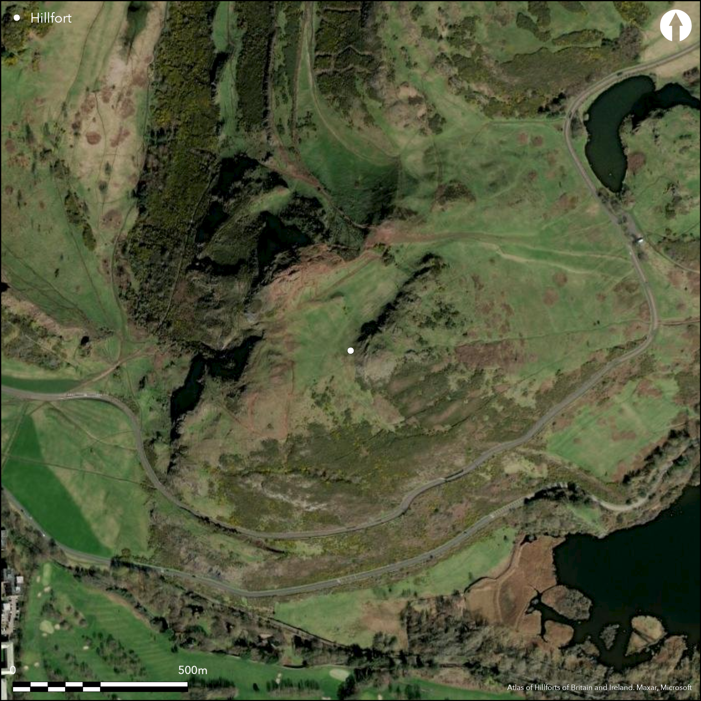
Arthur's Seat, the steep and craggy hill at the core of Holyrood Park in Edinburgh, is apparently the site of a large fort, though defences have only been been identified barring access to its upper slopes on the E, principally blocking access up a broad gully into the saddle between the summit on the NW and Crow Hill on the SE, and extending across the E face of Crow Hill above the system of cultivation terraces. The other flanks, which are steep but by no means inaccessible, were apparently left open and the size of the interior can be only roughly estimated at some 8.5ha. The defences comprise two ramparts, which on the floor of the gully both form substantial terraces overlain by later field-banks, and there is a possible entrance at the foot of a hillock on its NW side. In 1995 excavation along the line of the footpath to the summit of Arthur's Seat uncovered a band of rubble belonging to the inner extending NW from the hillock to the lip of the slope, while a section cut across its line on the hillock revealed that it was spread at least 5.4m in thickness by up to 1.2m in height (Alexander 1997). A possible round-house has been tentatively identified on the SE side of the gully a short distance up the slope from the inner ramaprt, but in view of the general absence of such features from the rest of the interior this feature is perhaps unrelated to the use and occupation of the fort.
Citizen Science: ✗
Reliability of Data: Confirmed
Reliability of Interpretation: Confirmed
X: -351773 Y: 7547082 (EPSG: 3857)
Longitude: -3.1600310987162317 Latitude: 55.943027901163475 (EPSG:4326)
Country: Scotland
Current County or Unitary Authority: City of Edinburgh
Historic County: Midlothian
Current Parish/Community/Council/Townland: Edinburgh
None
| Extant | ✓ |
| Cropmark | ✗ |
| Likely Destroyed | ✗ |
None
| Woodland | ✗ |
| Commercial Forestry Plantation | ✗ |
| Parkland | ✓ |
| Pasture (Grazing) | ✗ |
| Arable | ✗ |
| Scrub/Bracken | ✓ |
| Bare Outcrop | ✗ |
| Heather/Moorland | ✓ |
| Heath | ✗ |
| Built-up | ✗ |
| Coastal Grassland | ✗ |
| Other | ✗ |
None
| Contour Fort | ✓ |
| Partial Contour Fort | ✗ |
| Promontory Fort | ✗ |
| Hillslope Fort | ✗ |
| Level Terrain Fort | ✗ |
| Marsh Fort | ✗ |
| Multiple Enclosure Fort | ✗ |
| Hilltop | ✓ |
| Coastal Promontory | ✗ |
| Inland Promontory | ✗ |
| Valley Bottom | ✗ |
| Knoll/Hillock/Outcrop | ✗ |
| Ridge | ✗ |
| Cliff/Plateau-edge/Scarp | ✗ |
| Hillslope | ✗ |
| Lowland | ✗ |
| Spur | ✗ |
Dominant Topographic Feature: None
| North | ✗ |
| Northeast | ✗ |
| East | ✗ |
| Southeast | ✗ |
| South | ✗ |
| Southwest | ✗ |
| West | ✗ |
| Northwest | ✗ |
| Level | ✓ |
Altitude: 251.0m
N/A
There are neither stratified artefacts nor radiocarbon dates to provide a chronology for the defences.
Reliability: D - None
| Pre 1200BC | ✗ |
| 1200BC - 800BC | ✗ |
| 800BC - 400BC | ✗ |
| 400BC - AD50 | ✗ |
| AD50 - AD400 | ✗ |
| AD400 - AD 800 | ✗ |
| Post AD800 | ✗ |
| Unknown | ✓ |
| Pre Hillfort: | None |
| Post Hillfort: | Overlain by agricultural post-medieval enclosures and cultivation. An OS triangulation station and a viewpoint are set on the summit |
Photographed by RCAHMS Aerial Survey Programme as part of the more general recording of the archeology of the park.
| Earthwork Survey (1947): | Plan and description by Robert Stevenson (1947, 168-9, fig 3; RCAHMS 1951, 247-8, no.208, fig 429) |
| 1st Identified Map Depiction (1966): | OS 6-inch map |
| Other (1975): | Revised at 1:2500 by the OS |
| Other (1994): | Scheduled |
| Excavation (1995): | By Derek Alexander for CFA Archaeology (Alexander 1995; 1997) |
| Other (1998): | description and mapping by RCAHMS (1999) |
One possible round-house but otherwise featureless
None
| None | ✓ |
| Spring | ✗ |
| Stream | ✗ |
| Pool | ✗ |
| Flush | ✗ |
| Well | ✗ |
| Other | ✗ |
None
| No Known Features | ✓ |
| Round Stone Structures | ✗ |
| Rectangular Stone Structures | ✗ |
| Curvilinear Platforms | ✗ |
| Other Roundhouse Evidence | ✗ |
| Pits | ✗ |
| Quarry Hollows | ✗ |
| Other | ✗ |
None
| No Known Excavation | ✓ |
| Pits | ✗ |
| Postholes | ✗ |
| Roundhouses | ✗ |
| Rectangular Structures | ✗ |
| Roads/Tracks | ✗ |
| Quarry Hollows | ✗ |
| Other | ✗ |
| Nothing Found | ✗ |
None
| No Known Geophysics | ✓ |
| Pits | ✗ |
| Roundhouses | ✗ |
| Rectangular Structures | ✗ |
| Roads/Tracks | ✗ |
| Quarry Hollows | ✗ |
| Other | ✗ |
| Nothing Found | ✗ |
A range of stray finds have been recovered from Arthur's Seat, including: a microlith (RCAHMS Canmore 295832); a polished stone axe (RCAHMS Canmore 157276), a leaf-shaped flint arrowhead (RCAHMS Canmore 157208), a barbed-and-tanged flint arrowhead (RCAHMS Canmore 273412) part of a socketed bronze axe (RCAHMS Canmore 52461), and an inhumation in a cist with a rotary quern (RCAHMS Canmore 52122).
| No Known Finds | ✗ |
| Pottery | ✗ |
| Metal | ✗ |
| Metalworking | ✗ |
| Human Bones | ✓ |
| Animal Bones | ✗ |
| Lithics | ✓ |
| Environmental | ✗ |
| Other | ✓ |
NO APPARENT FEATURES
| APs Not Checked | ✗ |
| None | ✓ |
| Roundhouses | ✗ |
| Rectangular Structures | ✗ |
| Pits | ✗ |
| Postholes | ✗ |
| Roads/Tracks | ✗ |
| Other | ✗ |
See main summary
| 1: | None |
| 2: | None |
Guard Chambers: ✗
Chevaux de Frise: ✗
| 1. Simple Gap (North east): | None |
Two ramparts around the NE and E flanks
| Area 1: | 8.5ha. |
| Total: | 8.5ha. |
Total Footprint Area: Noneha.
None
| ✗ | None |
| ✗ | None |
| NE Quadrant: | 2 |
| SE Quadrant: | 0 |
| SW Quadrant: | 0 |
| NW Quadrant: | 0 |
| Total: | 2 |
| Partial Univallate | ✗ |
| Univallate | ✗ |
| Partial Bivallate | ✓ |
| Bivallate | ✗ |
| Partial Multivallate | ✗ |
| Multivallate | ✗ |
| Unknown | ✗ |
| Partial Univallate | ✗ |
| Univallate | ✗ |
| Partial Bivallate | ✗ |
| Bivallate | ✗ |
| Partial Multivallate | ✗ |
| Multivallate | ✗ |
None
| None | ✗ |
| Earthen Bank | ✗ |
| Stone Wall | ✗ |
| Rubble | ✓ |
| Wall-walk | ✗ |
| Evidence of Timber | ✗ |
| Vitrification | ✗ |
| Other Burning | ✗ |
| Palisade | ✗ |
| Counter Scarp Bank | ✗ |
| Berm | ✗ |
| Unfinished | ✗ |
| Other | ✗ |
None
| None | ✗ |
| Earthen Bank | ✗ |
| Stone Wall | ✓ |
| Murus Duplex | ✗ |
| Timber-framed | ✗ |
| Timber-laced | ✗ |
| Vitrification | ✗ |
| Other Burning | ✗ |
| Palisade | ✗ |
| Counter Scarp Bank | ✗ |
| Berm | ✗ |
| Unfinished | ✗ |
| No Known Excavation | ✗ |
| Other | ✗ |
| ✗ | None |
| ✗ | None |
Number of Ditches: None
| ✗ | None |
Alexander, D (1995) 'Arthur's Seat (City parish of Edinburgh), fort rampart'. Disc Exc Scot (1995), 54
Alexander, D (1997) 'Excavation on Arthur's Seat fort, Edinburgh, 1995'. Proc Soc Antiq Scot 127 (1997), 595-600
Feachem, R W (1963) A guide to prehistoric Scotland. Batsford: London (p 135)
RCAHMS (1951) The Royal Commission on the Ancient Monuments of Scotland. An inventory of the ancient and historical monuments of the city of Edinburgh with the thirteenth report of the Commission. HMSO: Edinburgh
RCAHMS. (1999) The Royal Commission on the Ancient Monuments of Scotland. Holyrood Park: the archaeology of the Royal Park, RCAHMS Broadsheet 6. RCAHMS: Edinburgh
Stevenson, R B K (1947) 'Farms and fortifications in the King's Park, Edinburgh'. Proc Soc Antiq Scot 81 (1946-7), 158-70
Atlas of Hillforts:
Wikidata:
This work is licensed under CC BY-SA 4.0![]()
![]()
![]() and should be cited as:
and should be cited as:
Lock, Gary and Ralston, Ian. 2024. Atlas of Hillforts of Britain and Ireland. Available at: https://hillforts.arch.ox.ac.uk
Document Version 1.1