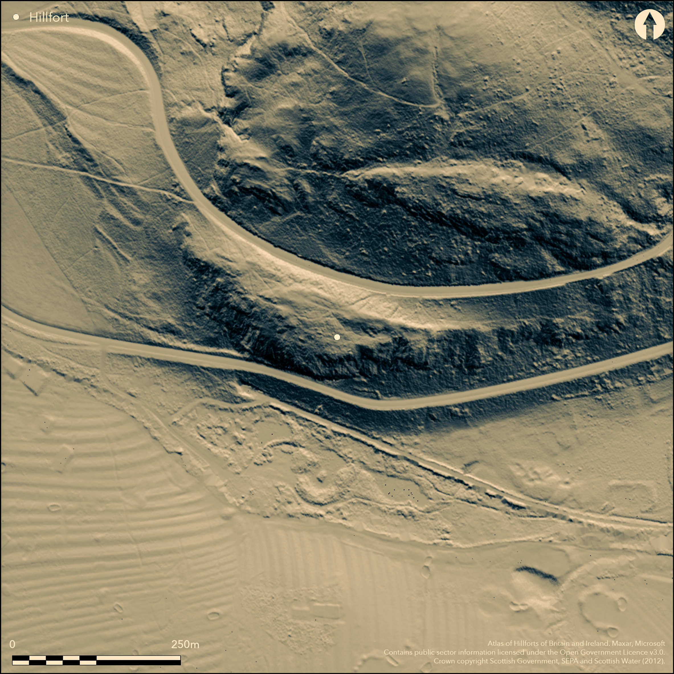
LiDAR 1m DTM Hillshade
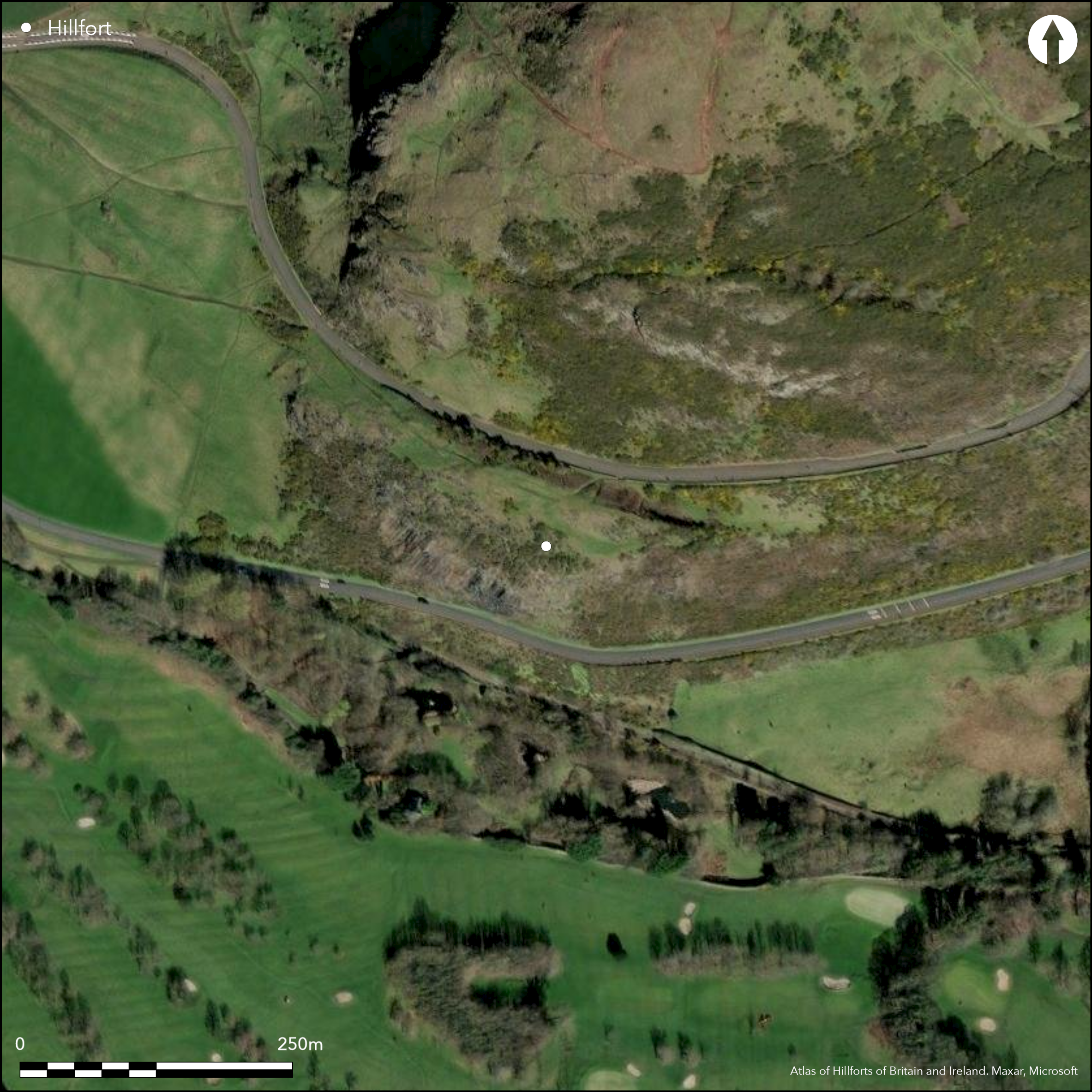
Satellite Imagery
LiDAR 1m DTM Hillshade
Satellite Imagery
Scroll left/right to view further images.
HER: City of Edinburgh No record found (None)
NMR: NT 27 SE 118 (52121)
SM: 13032
NGR: NT 2745 7249
X: 327450 Y: 672492 (OSGB36)
This fort is situated on an elongated hillock low down on the SW flank of Arthurs Seat, immediately S of the road leading round past Dunsapie Loch. The road here lies in a gully forming the N flank of the hillock, which elsewhere on the S and SW falls away in cliffs. The N flank, is thus relatively easy of access and has been defended by a single rampart drawn along its lip from the E tip to return across the outcrops to the cliff-edge on the W; stretches of outer face can be seen towards the E end, while a cleft in the outcrops on the WNW probably marks the position of the entrance, leading out into an outer enclosure or annexe extending down the slope on the WNW. The rocky interior of the inner enclosure measures about 95m from ESE to WNW by up to 45m transversely (0.43), while the outer enclosure measures about 40m by 25m respectively within its rampart and has an entrance on the WNW. Within the inner enclosure there are traces of at least one possible round-house, comprising a shallow scoop at the foot of an outcrop on one side and a stony bank on the other. A wall some 14m in length recorded by Robert Stevenson (1970, 293, fig 4) at the SE end of the annexe appears to be of later date rather than an element of the defences.
Citizen Science: ✗
Reliability of Data: Confirmed
Reliability of Interpretation: Confirmed
X: -352109 Y: 7546486 (EPSG: 3857)
Longitude: -3.1630473288265883 Latitude: 55.940025220777144 (EPSG:4326)
Country: Scotland
Current County or Unitary Authority: City of Edinburgh
Historic County: Midlothian
Current Parish/Community/Council/Townland: Edinburgh
None
| Extant | ✓ |
| Cropmark | ✗ |
| Likely Destroyed | ✗ |
None
| Woodland | ✗ |
| Commercial Forestry Plantation | ✗ |
| Parkland | ✓ |
| Pasture (Grazing) | ✗ |
| Arable | ✗ |
| Scrub/Bracken | ✗ |
| Bare Outcrop | ✗ |
| Heather/Moorland | ✓ |
| Heath | ✗ |
| Built-up | ✗ |
| Coastal Grassland | ✗ |
| Other | ✗ |
None
| Contour Fort | ✗ |
| Partial Contour Fort | ✗ |
| Promontory Fort | ✓ |
| Hillslope Fort | ✗ |
| Level Terrain Fort | ✗ |
| Marsh Fort | ✗ |
| Multiple Enclosure Fort | ✗ |
| Hilltop | ✗ |
| Coastal Promontory | ✗ |
| Inland Promontory | ✓ |
| Valley Bottom | ✗ |
| Knoll/Hillock/Outcrop | ✗ |
| Ridge | ✗ |
| Cliff/Plateau-edge/Scarp | ✗ |
| Hillslope | ✗ |
| Lowland | ✗ |
| Spur | ✗ |
Dominant Topographic Feature: None
| North | ✗ |
| Northeast | ✗ |
| East | ✗ |
| Southeast | ✗ |
| South | ✗ |
| Southwest | ✗ |
| West | ✗ |
| Northwest | ✗ |
| Level | ✓ |
Altitude: 125.0m
N/A
An itaglio dating from the 1st century AD was found within the interior in 1969 (Stevenson 1973), but defences remain undated.
Reliability: D - None
| Pre 1200BC | ✗ |
| 1200BC - 800BC | ✗ |
| 800BC - 400BC | ✗ |
| 400BC - AD50 | ✗ |
| AD50 - AD400 | ✗ |
| AD400 - AD 800 | ✗ |
| Post AD800 | ✗ |
| Unknown | ✓ |
| Pre Hillfort: | None |
| Post Hillfort: | None |
| Artefactual: | Itaglio found within the interior |
Photographed by RCAHMS Aerial Survey Programme as part of the more general recording of the archeology of the park.
| Earthwork Survey (1969): | Plan and description by Robert Stevenson following discovery of the itaglio (1970, 293, fig 4) |
| Other (1975): | Visited by the OS |
| Other (1998): | Description and mapped by RCAHMS (1999) |
Possible traces of a round-house; Robert Stevenson identified two to the rear of the rampart at the W end but these were not visibel more recently
None
| None | ✓ |
| Spring | ✗ |
| Stream | ✗ |
| Pool | ✗ |
| Flush | ✗ |
| Well | ✗ |
| Other | ✗ |
None
| No Known Features | ✓ |
| Round Stone Structures | ✗ |
| Rectangular Stone Structures | ✗ |
| Curvilinear Platforms | ✗ |
| Other Roundhouse Evidence | ✗ |
| Pits | ✗ |
| Quarry Hollows | ✗ |
| Other | ✗ |
None
| No Known Excavation | ✓ |
| Pits | ✗ |
| Postholes | ✗ |
| Roundhouses | ✗ |
| Rectangular Structures | ✗ |
| Roads/Tracks | ✗ |
| Quarry Hollows | ✗ |
| Other | ✗ |
| Nothing Found | ✗ |
None
| No Known Geophysics | ✓ |
| Pits | ✗ |
| Roundhouses | ✗ |
| Rectangular Structures | ✗ |
| Roads/Tracks | ✗ |
| Quarry Hollows | ✗ |
| Other | ✗ |
| Nothing Found | ✗ |
Itaglio of 1st century AD date
| No Known Finds | ✗ |
| Pottery | ✗ |
| Metal | ✗ |
| Metalworking | ✗ |
| Human Bones | ✗ |
| Animal Bones | ✗ |
| Lithics | ✗ |
| Environmental | ✗ |
| Other | ✓ |
NO APPARENT FEATURES
| APs Not Checked | ✗ |
| None | ✓ |
| Roundhouses | ✗ |
| Rectangular Structures | ✗ |
| Pits | ✗ |
| Postholes | ✗ |
| Roads/Tracks | ✗ |
| Other | ✗ |
See main summary
| 1: | None |
| 2: | None |
Guard Chambers: ✗
Chevaux de Frise: ✗
| 1. Simple Gap (North west): | None |
Single rampart on two sides, with an annexe to the WNW
| Area 1: | 0.43ha. |
| Total: | 0.43ha. |
Total Footprint Area: 0.0ha.
None
| ✗ | None |
| ✗ | None |
| NE Quadrant: | 1 |
| SE Quadrant: | 0 |
| SW Quadrant: | 0 |
| NW Quadrant: | 1 |
| Total: | 1 |
| Partial Univallate | ✓ |
| Univallate | ✗ |
| Partial Bivallate | ✗ |
| Bivallate | ✗ |
| Partial Multivallate | ✗ |
| Multivallate | ✗ |
| Unknown | ✗ |
| Partial Univallate | ✗ |
| Univallate | ✗ |
| Partial Bivallate | ✗ |
| Bivallate | ✗ |
| Partial Multivallate | ✗ |
| Multivallate | ✗ |
None
| None | ✗ |
| Earthen Bank | ✗ |
| Stone Wall | ✓ |
| Rubble | ✗ |
| Wall-walk | ✗ |
| Evidence of Timber | ✗ |
| Vitrification | ✗ |
| Other Burning | ✗ |
| Palisade | ✗ |
| Counter Scarp Bank | ✗ |
| Berm | ✗ |
| Unfinished | ✗ |
| Other | ✗ |
None
| None | ✗ |
| Earthen Bank | ✗ |
| Stone Wall | ✗ |
| Murus Duplex | ✗ |
| Timber-framed | ✗ |
| Timber-laced | ✗ |
| Vitrification | ✗ |
| Other Burning | ✗ |
| Palisade | ✗ |
| Counter Scarp Bank | ✗ |
| Berm | ✗ |
| Unfinished | ✗ |
| No Known Excavation | ✓ |
| Other | ✗ |
| ✗ | None |
| ✗ | None |
Number of Ditches: None
| ✓ | The remains of a rampart form the NE and NW sides of an annexe dropping down the slope at this end of the fort and measuring internally about 40m from ESE to WNW by 25m transversely (0.9ha) within its rampart; It has an entrance on the WNW and communicates with the interior of the fort on the ESE |
Stevenson, R B K (1973) 'A Roman intaglio ring from a native fort on Arthur's Seat, Edinburgh'. Proc Soc Antiq Scot 102 (1969-70), 293-4
RCAHMS. (1999) The Royal Commission on the Ancient Monuments of Scotland. Holyrood Park: the archaeology of the Royal Park, RCAHMS Broadsheet 6. RCAHMS: Edinburgh
Atlas of Hillforts:
Wikidata:
This work is licensed under CC BY-SA 4.0![]()
![]()
![]() and should be cited as:
and should be cited as:
Lock, Gary and Ralston, Ian. 2024. Atlas of Hillforts of Britain and Ireland. Available at: https://hillforts.arch.ox.ac.uk
Document Version 1.1