LiDAR 1m DTM Hillshade

Satellite Imagery
LiDAR 1m DTM Hillshade
Satellite Imagery
Scroll left/right to view further images.
HER: Scottish Borders 53304 (None)
NMR: NT 35 SE 6 (53304)
SM: 1166
NGR: NT 3925 5190
X: 339250 Y: 651900 (OSGB36)
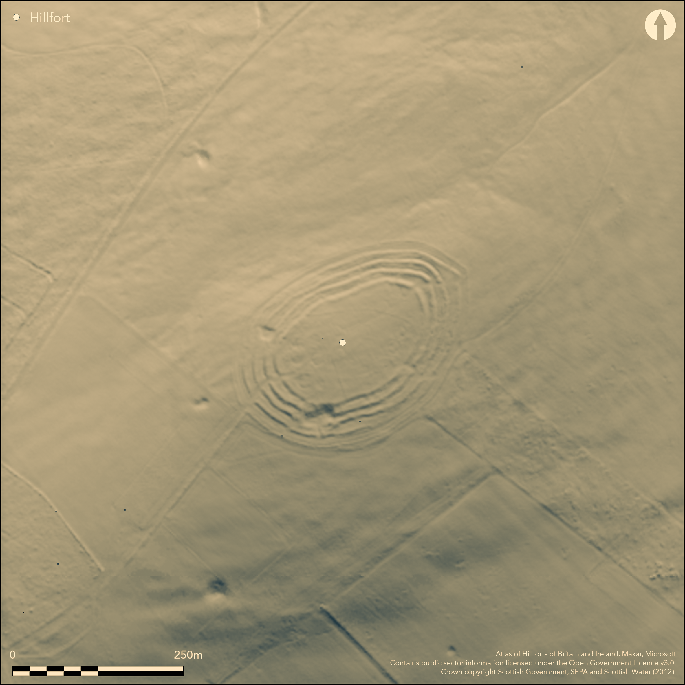
Corsehope Rings crown the summit of Mid Hill, which forms part of a long ridge between the Heriot Water on the NW and the Corsehope Burn on the SE. Oval on plan, the fort measures 128m from NE to SW by 81m transversely within a remarkable belt of defences between 30m and 40m deep. Roughly concentric, the belt comprises at least four relatively slight ramparts accompanied by shallow external ditches, the gaps between them opening up a little at both ends to increase the depth of the defences adjacent to the axial entrances on the NE and SW respectively, but what is truly remarkable are the traces of palisade trenches cut along the crest of each rampart. These almost certainly represent a refurbishment phase after the rampart cores had consolidated, and at the SW entrance the relationship is clearly demonstrated by the way the palisade trench on the outermost rampart dismounts on the S side of the entrance to return around the terminal of the ditch and cut obliquely across the low counterscarp bank that is visible in this sector. At this same entrance, a length of trench surviving on the S side of the entrance also links the palisades on the innermost and second ramparts, evidently representing part of a timber-lined passage leading into the interior. The ramparts and palisades appear to represent two coherent schemes for defence in depth, but between the second and third ramparts on the S side of the NE entrance there are traces of other low banks, suggesting that the evolution of the defences may yet be more complex, while at the SW end of the interior there are traces of what may be two successive palisade trenches incorporating the line of the inner rampart into the perimeter of later settlement enclosures. Within these enclosures there are at least three substantial ring-ditch house, and traces of at least fourteen others can be seen throughout the rest of the interior of the fort, despite an episode of shallow cultivation in the post-medieval period; two of the round-houses, lying immediately inside a third entrance that pierces the defences on the SE, are encircled by twin ring-grooves. The traces of later cultivation ride over what is probably a post-medieval dyke cutting obliquely across the interior in a shallow arc from E to W, and at some stage the whole fort was enclosed by a turf dyke, traces of which can be seen outside the defences in most sectors; a deep quarry has also been cut across the defences on the S.
Citizen Science: ✗
Reliability of Data: Confirmed
Reliability of Interpretation: Confirmed
X: -330569 Y: 7510127 (EPSG: 3857)
Longitude: -2.9695537020905483 Latitude: 55.75666907592297 (EPSG:4326)
Country: Scotland
Current County or Unitary Authority: Scottish Borders
Historic County: Midlothian
Current Parish/Community/Council/Townland: Heriot
None
| Extant | ✓ |
| Cropmark | ✗ |
| Likely Destroyed | ✗ |
None
| Woodland | ✗ |
| Commercial Forestry Plantation | ✗ |
| Parkland | ✗ |
| Pasture (Grazing) | ✓ |
| Arable | ✗ |
| Scrub/Bracken | ✗ |
| Bare Outcrop | ✗ |
| Heather/Moorland | ✓ |
| Heath | ✗ |
| Built-up | ✗ |
| Coastal Grassland | ✗ |
| Other | ✗ |
None
| Contour Fort | ✓ |
| Partial Contour Fort | ✗ |
| Promontory Fort | ✗ |
| Hillslope Fort | ✗ |
| Level Terrain Fort | ✗ |
| Marsh Fort | ✗ |
| Multiple Enclosure Fort | ✗ |
| Hilltop | ✓ |
| Coastal Promontory | ✗ |
| Inland Promontory | ✗ |
| Valley Bottom | ✗ |
| Knoll/Hillock/Outcrop | ✗ |
| Ridge | ✗ |
| Cliff/Plateau-edge/Scarp | ✗ |
| Hillslope | ✗ |
| Lowland | ✗ |
| Spur | ✗ |
Dominant Topographic Feature: None
| North | ✗ |
| Northeast | ✗ |
| East | ✗ |
| Southeast | ✗ |
| South | ✗ |
| Southwest | ✗ |
| West | ✗ |
| Northwest | ✗ |
| Level | ✓ |
Altitude: 404.0m
N/A
In the absence of modern excavation, there are neither stratified artefacts nor radiocarbon dates to provide a chronology for the defences.
Reliability: D - None
| Pre 1200BC | ✗ |
| 1200BC - 800BC | ✗ |
| 800BC - 400BC | ✗ |
| 400BC - AD50 | ✗ |
| AD50 - AD400 | ✗ |
| AD400 - AD 800 | ✗ |
| Post AD800 | ✗ |
| Unknown | ✓ |
| Pre Hillfort: | None |
| Post Hillfort: | Enclosed by a turf dyke and the interior slightly improved by a shallow cultivation, that rides over what is probably another dyke; a deep quarry has been cut across the defences on the S |
Photographed by John Dewar in 1971 (held by RCAHMS), CUCAP in 1979, by Mike Brooks of Historic Scotland in 1979, and RCAHMS Aerial Survey Programme under a wide range of conditions in 1981, 1982, 1985, 1986, 1989, 1996, 1998, 2010 and 2013. Also visited on numerous occasions by S Halliday (2013)
| 1st Identified Map Depiction (1773): | Concentric ring on a hill symbol on Mostyn Armstrong's Map of the three Lothians (1773) |
| Other (1853): | Annotated Camp on the 1st edition OS 6-inch map (Edinburghshire 1854, sheet 23) |
| Earthwork Survey (1879): | Fine measured plan and description by William Galloway (1880, 254, fig) ; RCAHMS DC54491 & DP110698) |
| Excavation (1879): | Trench cut across the defences by William Galloway (1880, 258-9); Galloway also refers to earlier excavations by J Y Simpson |
| Other (1892): | Annotated Fort on the OS 25-inch map (Edinburghshire 1894, sheet 21.9 & 21.13 ) |
| Other (1892): | Description and drawn profiles by David Christison and Fred Coles (Christison 1895, 117-18, fig 5) |
| Other (1913): | Description by J G Callander for RCAHMS (RCAHMS 1929, 76-8, no.108) |
| Earthwork Survey (1915): | Plan to accompany Callander's description (RCAHMS 1929, 76-8, no.108, fig 99; RCAHMS MLD 17/1) |
| Other (1924): | Scheduled |
| Earthwork Survey (1948): | Robert Stevenson sketches round-houses onto the RCAHMS plan (1949, 2, fig 2) |
| Earthwork Survey (1954): | Part of SE arc surveyed as part of the RCAHMS Survey of Marginal Lands (RCAHMS MLD 17/4). Brief Description (Feachem 1963, 138) |
| Other (1962): | Re-Scheduled |
| Other (1970): | Resurveyed at 1:2500 by the OS |
| Other (1979): | Palisade trenches identified by Peter Hill through oblique aerial photography and subsequent fieldwork |
Despite light improvement, the interior contains traces of at least seventeen ring-ditch houses and two or three subsidiary palisaded enclosure.
None
| None | ✓ |
| Spring | ✗ |
| Stream | ✗ |
| Pool | ✗ |
| Flush | ✗ |
| Well | ✗ |
| Other | ✗ |
At least seventeen timber round-houses, the majority of which are ring-ditch houses, and include two with enclosing double ring-grooves; there are also at least two subsidiary palisaded enclosures utilising the SW end of the enclosure.
| No Known Features | ✗ |
| Round Stone Structures | ✗ |
| Rectangular Stone Structures | ✗ |
| Curvilinear Platforms | ✗ |
| Other Roundhouse Evidence | ✓ |
| Pits | ✗ |
| Quarry Hollows | ✗ |
| Other | ✓ |
None
| No Known Excavation | ✓ |
| Pits | ✗ |
| Postholes | ✗ |
| Roundhouses | ✗ |
| Rectangular Structures | ✗ |
| Roads/Tracks | ✗ |
| Quarry Hollows | ✗ |
| Other | ✗ |
| Nothing Found | ✗ |
None
| No Known Geophysics | ✓ |
| Pits | ✗ |
| Roundhouses | ✗ |
| Rectangular Structures | ✗ |
| Roads/Tracks | ✗ |
| Quarry Hollows | ✗ |
| Other | ✗ |
| Nothing Found | ✗ |
None
| No Known Finds | ✓ |
| Pottery | ✗ |
| Metal | ✗ |
| Metalworking | ✗ |
| Human Bones | ✗ |
| Animal Bones | ✗ |
| Lithics | ✗ |
| Environmental | ✗ |
| Other | ✗ |
At least seventeen
| APs Not Checked | ✗ |
| None | ✗ |
| Roundhouses | ✓ |
| Rectangular Structures | ✗ |
| Pits | ✗ |
| Postholes | ✗ |
| Roads/Tracks | ✗ |
| Other | ✗ |
See main summary
| 4: | A quarry has been dug across the defences on the SSW |
| 2: | None |
Guard Chambers: ✗
Chevaux de Frise: ✗
| 1. Simple Gap (North east): | Through the ramparts and ditches |
| 2. Simple Gap (South east): | Through the ramparts and ditches |
| 3. Simple Gap (South west): | Through the ramparts and ditches |
| 3. Passage-way/Corridor (South west): | The timberwork re-cutting the entrance through the earthwork defences includes a line passage through thr two inner ramparts |
At least four ramparts with external quarry ditches, with evidence that they have been recut with palisade trenches all round the circuit. On the E there are traces of one or two intermediate lines between the second and third ramparts, and a counterscarp bank accompanying the outermost ditch on the SW.
| Area 1: | 0.83ha. |
| Total: | 0.83ha. |
Total Footprint Area: 2.4ha.
None
| ✓ | None |
| ✓ | None |
| NE Quadrant: | 4 |
| SE Quadrant: | 4 |
| SW Quadrant: | 4 |
| NW Quadrant: | 4 |
| Total: | 4 |
| Partial Univallate | ✗ |
| Univallate | ✗ |
| Partial Bivallate | ✗ |
| Bivallate | ✗ |
| Partial Multivallate | ✗ |
| Multivallate | ✓ |
| Unknown | ✗ |
| Partial Univallate | ✗ |
| Univallate | ✗ |
| Partial Bivallate | ✗ |
| Bivallate | ✗ |
| Partial Multivallate | ✗ |
| Multivallate | ✗ |
None
| None | ✗ |
| Earthen Bank | ✓ |
| Stone Wall | ✗ |
| Rubble | ✗ |
| Wall-walk | ✗ |
| Evidence of Timber | ✗ |
| Vitrification | ✗ |
| Other Burning | ✗ |
| Palisade | ✓ |
| Counter Scarp Bank | ✓ |
| Berm | ✗ |
| Unfinished | ✗ |
| Other | ✗ |
Sectioned by William Galloway
| None | ✗ |
| Earthen Bank | ✓ |
| Stone Wall | ✗ |
| Murus Duplex | ✗ |
| Timber-framed | ✗ |
| Timber-laced | ✗ |
| Vitrification | ✗ |
| Other Burning | ✗ |
| Palisade | ✗ |
| Counter Scarp Bank | ✗ |
| Berm | ✗ |
| Unfinished | ✗ |
| No Known Excavation | ✗ |
| Other | ✗ |
| ✗ | None |
| ✓ | None |
Number of Ditches: 4
| ✗ | None |
Christison, D (1895) 'The forts of Selkirk, the Gala Water, the Southern slopes of the Lammermoors, and the north of Roxburgh'. Proc Soc Antiq Scot 29 (1894-50), 108-79
Feachem, R (1963) A guide to prehistoric Scotland. Batsford: London
Galloway, W (1880) 'Notice of a camp on the Midhill-Head, on the estate of Borthwick Hall, in the parish of Heriot, Midlothian, the property of D. J. Macfie, Esq'. Proc Soc Antiq Scot 14 (1879-80), 254-60
Halliday, S (2013) 'I Walked, I Saw, I Surveyed, but what did I see?... and what did I survey'. 65-77 in Opitz, R S and Cowley, D C (eds) Interpreting Archaeological Topography - Airborne Laser Scanning, 3D Data and Ground Observation. Oxbow: Oxford
RCAHMS (1929) The Royal Commission on the Ancient and Historical Monuments and Constructions of Scotland. Tenth report with Inventory of Monuments and Constructions in the Counties of Midlothian and West Lothian. HMSO: Edinburgh
Stevenson, R B K (1949) 'Braidwood fort, Midlothian: the exploration of two huts'. Proc Soc Antiq Scot 83 (1948-9), 1-11
Atlas of Hillforts:
Wikidata:
This work is licensed under CC BY-SA 4.0![]()
![]()
![]() and should be cited as:
and should be cited as:
Lock, Gary and Ralston, Ian. 2024. Atlas of Hillforts of Britain and Ireland. Available at: https://hillforts.arch.ox.ac.uk
Document Version 1.1