LiDAR 1m DTM Hillshade
Satellite Imagery
LiDAR 1m DTM Hillshade
Satellite Imagery
Scroll left/right to view further images.
HER: Scottish Borders 54472 (None)
NMR: NT 44 NE 3 (54472)
SM: 1168
NGR: NT 4540 4567
X: 345400 Y: 645670 (OSGB36)
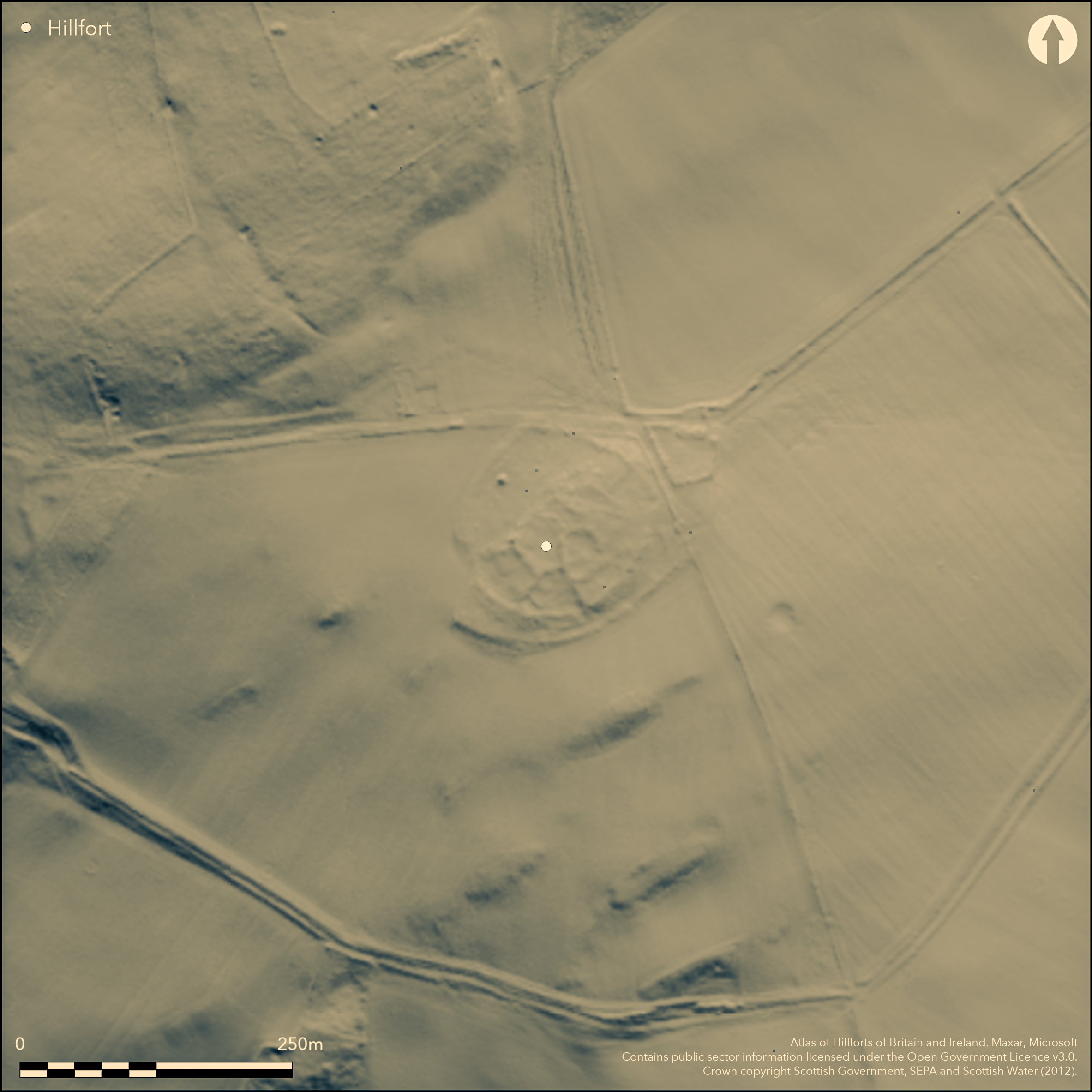
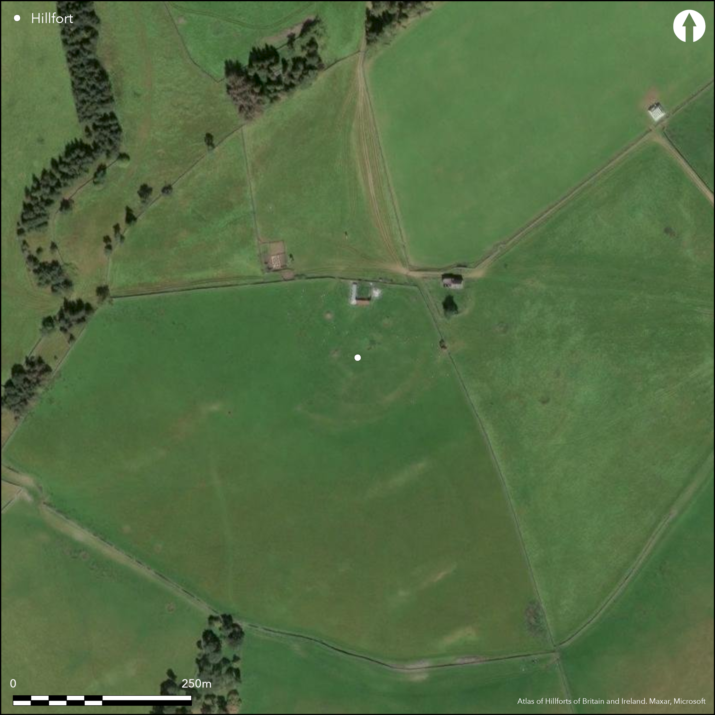
This fort is situated on a spur projecting from the SE flank of Craigend Hill on the NE side of the Gala Water NW of Stow. Enclosed within improved fields, however, the defences have been mutilated by stone-robbing and cultivation, while the interior is largely occupied by a series of courts and yards that probably form part of an overlying late Iron Age settlement. The presence of the latter has confused the various antiquaries, archaeologists and surveyors who have visited since, and though most agree that the defences comprise two ramparts, their estimates of the size of the interior vary widely. Nevertheless, oblique aerial photography and satellite imagery suggest that the fort is oval on plan, measuring about 100m from NE to SW by 85m transversely (0.68ha) within the inner rampart, which on the SE forms a scarp about 1.4m high. Traces of the outer rampart, which does not appear to be strictly concentric, are visible only on the S and SE; elsewhere it has been obliterated by cultivation and even in this sector there is no more than a low scarp about 0.5m in height. A gap in the inner rampart on the WSW probably marks the position of an entrance.
Citizen Science: ✗
Reliability of Data: Confirmed
Reliability of Interpretation: Confirmed
X: -319523 Y: 7499207 (EPSG: 3857)
Longitude: -2.8703264955943117 Latitude: 55.701431278017644 (EPSG:4326)
Country: Scotland
Current County or Unitary Authority: Scottish Borders
Historic County: Midlothian
Current Parish/Community/Council/Townland: Stow
None
| Extant | ✓ |
| Cropmark | ✗ |
| Likely Destroyed | ✗ |
None
| Woodland | ✗ |
| Commercial Forestry Plantation | ✗ |
| Parkland | ✗ |
| Pasture (Grazing) | ✓ |
| Arable | ✗ |
| Scrub/Bracken | ✗ |
| Bare Outcrop | ✗ |
| Heather/Moorland | ✗ |
| Heath | ✗ |
| Built-up | ✗ |
| Coastal Grassland | ✗ |
| Other | ✗ |
None
| Contour Fort | ✓ |
| Partial Contour Fort | ✗ |
| Promontory Fort | ✗ |
| Hillslope Fort | ✗ |
| Level Terrain Fort | ✗ |
| Marsh Fort | ✗ |
| Multiple Enclosure Fort | ✗ |
| Hilltop | ✗ |
| Coastal Promontory | ✗ |
| Inland Promontory | ✗ |
| Valley Bottom | ✗ |
| Knoll/Hillock/Outcrop | ✓ |
| Ridge | ✗ |
| Cliff/Plateau-edge/Scarp | ✗ |
| Hillslope | ✗ |
| Lowland | ✗ |
| Spur | ✗ |
Dominant Topographic Feature: None
| North | ✗ |
| Northeast | ✗ |
| East | ✗ |
| Southeast | ✗ |
| South | ✗ |
| Southwest | ✗ |
| West | ✗ |
| Northwest | ✗ |
| Level | ✓ |
Altitude: 265.0m
N/A
In the absence of excavation, there are neither stratified artefacts nor radiocarbon dates to provide a chronology for the defences.
Reliability: D - None
| Pre 1200BC | ✗ |
| 1200BC - 800BC | ✗ |
| 800BC - 400BC | ✗ |
| 400BC - AD50 | ✗ |
| AD50 - AD400 | ✗ |
| AD400 - AD 800 | ✗ |
| Post AD800 | ✗ |
| Unknown | ✓ |
| Pre Hillfort: | None |
| Post Hillfort: | Overlain by courts an enclosures of what is probably a late Iron Age settlement |
Photographed from the air by John Dent 1991, and by RCAHMS Aerial Survey Programme in 1981, 1993 and 2010
| 1st Identified Map Depiction (1853): | Annotated Camp on the 1st edition OS 6-inch map (Edinburghshire 1853, sheet |
| Other (1892): | Depiction on OS 25-inch map (Edinburghshire 1894, sheet 23.12) |
| Other (1894): | Description by David Christison and James Wilson (Christison 1895, 121-2) |
| Other (1912): | Items found in the fort exhibited (Proc Soc Antiq Scot 46, 1911-12, 377-8) |
| Other (1913): | Description (RCAHMS 1929, 171, no.239) |
| Other (1935): | Scheduled |
| Other (1954): | Visited during the RCAHMS Survey of Marginal Lands |
| Other (1964): | Revised at 1:2500 by the OS |
The interior is overlain by a series of enclosures and courts, which are likely to represent a late Iron Age settlement
None
| None | ✓ |
| Spring | ✗ |
| Stream | ✗ |
| Pool | ✗ |
| Flush | ✗ |
| Well | ✗ |
| Other | ✗ |
Overlying courts and enclosures
| No Known Features | ✗ |
| Round Stone Structures | ✗ |
| Rectangular Stone Structures | ✗ |
| Curvilinear Platforms | ✗ |
| Other Roundhouse Evidence | ✗ |
| Pits | ✗ |
| Quarry Hollows | ✗ |
| Other | ✓ |
None
| No Known Excavation | ✓ |
| Pits | ✗ |
| Postholes | ✗ |
| Roundhouses | ✗ |
| Rectangular Structures | ✗ |
| Roads/Tracks | ✗ |
| Quarry Hollows | ✗ |
| Other | ✗ |
| Nothing Found | ✗ |
None
| No Known Geophysics | ✓ |
| Pits | ✗ |
| Roundhouses | ✗ |
| Rectangular Structures | ✗ |
| Roads/Tracks | ✗ |
| Quarry Hollows | ✗ |
| Other | ✗ |
| Nothing Found | ✗ |
Finds attributed to the fort and exhibited in 1912 to the Society of Antiquaries (Proc Soc Antiq Scot 46, 1911-12, 377-8) by a Mr Sulley of Galashiels include: a sandstone flat axe mould of sandstone, found in a pit; a piece of slate with incised lines; a piece of rough clay pottery showing potter's wheel marks; a piece of animal bone cut as a saw, found in the inner ditch;, a cast of a perforated and decorated stone; and two decorated whorls.
| No Known Finds | ✗ |
| Pottery | ✓ |
| Metal | ✗ |
| Metalworking | ✓ |
| Human Bones | ✗ |
| Animal Bones | ✓ |
| Lithics | ✗ |
| Environmental | ✗ |
| Other | ✓ |
Courts and enclosures
| APs Not Checked | ✗ |
| None | ✗ |
| Roundhouses | ✗ |
| Rectangular Structures | ✗ |
| Pits | ✗ |
| Postholes | ✗ |
| Roads/Tracks | ✗ |
| Other | ✓ |
See main summary
| 1: | Large sectors are effectively levelled |
| 2: | None |
Guard Chambers: ✗
Chevaux de Frise: ✗
| 1. Simple Gap (South west): | Through inner rampart |
At least two ramparts, though the whole site is heavily disturbed, in the first instance by the construction of what is probably an overlying late Iron Age settlement, and in the second by post-medieval robbing and cultivation survive
| Area 1: | 0.68ha. |
| Total: | 0.68ha. |
Total Footprint Area: Noneha.
None
| ✓ | The internal enclosures appear to ride over the inner rampart |
| ✗ | None |
| NE Quadrant: | 0 |
| SE Quadrant: | 2 |
| SW Quadrant: | 2 |
| NW Quadrant: | 1 |
| Total: | 2 |
| Partial Univallate | ✓ |
| Univallate | ✗ |
| Partial Bivallate | ✓ |
| Bivallate | ✗ |
| Partial Multivallate | ✗ |
| Multivallate | ✗ |
| Unknown | ✗ |
| Partial Univallate | ✗ |
| Univallate | ✗ |
| Partial Bivallate | ✗ |
| Bivallate | ✗ |
| Partial Multivallate | ✗ |
| Multivallate | ✗ |
None
| None | ✗ |
| Earthen Bank | ✗ |
| Stone Wall | ✗ |
| Rubble | ✓ |
| Wall-walk | ✗ |
| Evidence of Timber | ✗ |
| Vitrification | ✗ |
| Other Burning | ✗ |
| Palisade | ✗ |
| Counter Scarp Bank | ✗ |
| Berm | ✗ |
| Unfinished | ✗ |
| Other | ✗ |
None
| None | ✗ |
| Earthen Bank | ✗ |
| Stone Wall | ✗ |
| Murus Duplex | ✗ |
| Timber-framed | ✗ |
| Timber-laced | ✗ |
| Vitrification | ✗ |
| Other Burning | ✗ |
| Palisade | ✗ |
| Counter Scarp Bank | ✗ |
| Berm | ✗ |
| Unfinished | ✗ |
| No Known Excavation | ✓ |
| Other | ✗ |
| ✗ | None |
| ✗ | None |
Number of Ditches: None
| ✗ | None |
Christison, D (1895) 'The forts of Selkirk, the Gala Water, the Southern slopes of the Lammermoors, and the north of Roxburgh'. Proc Soc Antiq Scot 29 (1894-50), 108-79
RCAHMS (1929) The Royal Commission on the Ancient and Historical Monuments and Constructions of Scotland. Tenth report with Inventory of Monuments and Constructions in the Counties of Midlothian and West Lothian. HMSO: Edinburgh
Atlas of Hillforts:
Wikidata:
This work is licensed under CC BY-SA 4.0![]()
![]()
![]() and should be cited as:
and should be cited as:
Lock, Gary and Ralston, Ian. 2024. Atlas of Hillforts of Britain and Ireland. Available at: https://hillforts.arch.ox.ac.uk
Document Version 1.1